Using a particle based simulation to visualize
sub-catchment contributions to localized flooding
Mehdi Khoury1, Dragan Savic1, Lydia Vamvakeridou-Lyroudia1, Albert Chen1,
Slobodan Djordjevic1
1 Centre for Water Systems, University of Exeter, Exeter, United Kingdom
Corresponding author: [email protected]
Abstract. Using the Nvidia off-the-shelf particle based “Flex” simulation engine, we visualize the impact of rainfall over different sub-catchments on flooding in the village of Millbrook in the UK. Stakeholders are able to see what part of the catchment contributes most to which flooded area in the village. Hundreds of thousands of colored particles (balls), whose color is based on the quadrant of the catchment area, are dropped above the terrain and left to roll down while interacting with each other. The approach is similar to the ‘rolling ball’ method, which identifies natural flow pathways by rolling a ball down a digital elevation model, but uses multiple balls instead. Although the visualized results of our approach are of limited hydraulic accuracy, this type of visualization explains causality when analyzing the contribution of different portions of the terrain to the flooding from rainfall. This is possible due to colored deposits resembling well the final flood extent. Consequently, it is a useful technique for implementation in Serious Gaming, with flooding related themes, targeting in improving the understanding of stakeholders/players.
Keywords: flooding, visualisation, particle based visualisation, Serious Gaming
1 The Millbrook case study
Due to the proximity of an estuary, the village of Millbrook located in Devon in the United Kingdom, was vulnerable to tidal surges in the past. Significant work has therefore been done resulting in a tidal barrage constructed across the estuary, and leading to the creation of the Millbrook Lake. This is designed as a storage area to hold water from the freshwater streams and overland flow and prevent it from backing up in the village. Millbrook was affected in 2012 by two rainfall-related flood events in November and December where flooding was derived from river (fluvial) and surface (pluvial) sources. Although the risk of tidal flooding has been greatly diminished by
Engineering
EPiC Series in Engineering
Volume 3, 2018, Pages 1063–1069
HIC 2018. 13th International Conference on Hydroinformatics
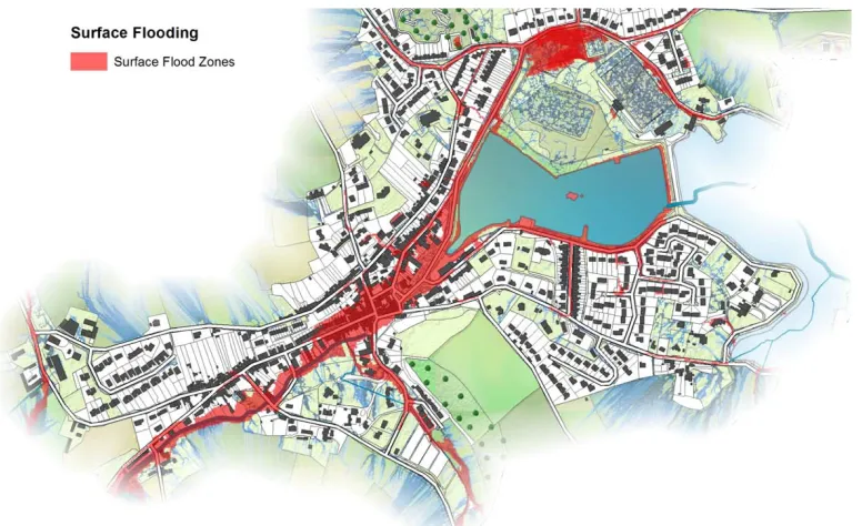
the Lake, to this day, some residents are still under the impression that the cause of the ongoing flooding problems is still tidal despite evidence to the contrary. Westcountry Rivers Trust, which was commissioned to help stakeholders understand their flood risk situation and come up with recommendation for risk reduction, has come up with a classic map based presentation of the flood footprint to show to the residents (Figure 1). This study presents a novel particle based visualisation system developed to show the contribution of the rainfall over each sub-catchment to the flood extent. The approach is based on using a 3D digital elevation model (DEM) of the terrain and spherical particles dropped on it, allowing them to roll down the DEM and accumulate. Although other particle systems have been recently used in the context of flood visualisation [1], it is the first time to our knowledge that coloured particle emitters have been used to show the pluvial contribution of sub-catchments. Furthermore, we also provide a detailed analysis of the constraints and limitations of particle systems such as Flex when applied to 3D flood visualisation.
2 The particle based visualisation
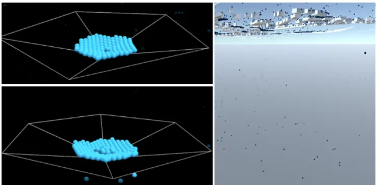
Hundreds of thousands of particles (particles) are emitted above the 3D DEM of the terrain by using the Nvidia Flex simulation engine [2], which is widely used in the video game industry. We have chosen four emitters in four quadrants of the area. Each emitter produces 32,000 spherical balls (a number optimised in this case for the GPU memory constraints) of a specific colour over a different quadrant of the catchment following a uniform random distribution of, as shown in Figure 2.
Figure 1 Standard visualisation of Millbrook flood extent
Using a Particle Based Simulation to Visualize Sub-Catchments Contribution to ... M. Khoury et al.
Figure 2 Details of the flood extent showing the pluvial contribution as deposits of particles (top and lower right) resulting from the quadrant coloured emitters (lower
left).
The physics engine computes in real time the flow path of all particles simultaneously by considering general parameters such as gravity, collisions with meshes and other particles, friction and maximum speed in the medium. Other parameters used for simulating groups of particles as a liquid such as cohesion, surface tension, and viscosity are also considered. Water infiltration rate of the ground is approximated by changing the speed at which emitted particles are re-used in the emitters and released again above the terrain. Although the visualisation is extremely helpful to distinguish the contribution of different pluvial sources to the flood print, this novel technology is essentially adopted from the domain of video game graphics. Therefore, in its present state it suffers from some limitations when used for flood visualisation.
3 Challenges and limitations of Flex particle based systems when visualising flooding. Discussion
Using an off-the-shelve particle based system such as the Flex engine to represent moving water present unique challenges, as follows:
Using a Particle Based Simulation to Visualize Sub-Catchments Contribution to ... M. Khoury et al.
Challenge A: The hardware and software constraints limit the maximum number of particles that can be emitted to a few hundred thousands in Unity3d. This can go up to a couple of millions in the Unreal engine [4], but to be close to reality, this number would need to be at least three orders of magnitude higher. To compensate for this limitation, the size of each sphere is increased to enlarge the volume of water and cover the required terrain surface. The downside of this change is that due to the size of particles they tend to form blockages in the narrow streets when colliding with buildings, which limits how close to a real liquid these particles behave.
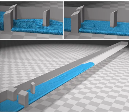
Challenge B: Due to the limitations of the underlying GPU based physics engine, there is an upper limit to the maximum number of planes (physical boundaries) each particle can collide with simultaneously (presently 5). If a particle collides with more than 5 planes at the same time, as it might sometimes happen with complex 3D triangular meshes, the physics engine will simply make the particle ignore all the collisions and go through the planes as if they did not exist. This means that if we drop many particles over a complex 3D DEM of a urban environment, there is a good chance that many particles will simply fall through the mesh unless the mesh surface as shown in Figure 3.
Figure 3 Particles collide with the mesh correctly if it touches up to 5 planes at the same time (upper left). They simply pass through the mesh if they are in contact with
more planes (lower left, right).
One way to minimise that problem is to use a mesh editor such as Meshlab [5] and apply a simplification algorithm. For example, the Quadric Based Edge Collapse Decimation algorithm [6] preserves boundaries, topology, while reducing the number of polygons making the mesh surface. There is obviously a trade-off between simplification and accuracy. The same problem also happens if the number of particles
Using a Particle Based Simulation to Visualize Sub-Catchments Contribution to ... M. Khoury et al.
is so high that the engine does not have enough resources to solve all the collisions fast enough, causing the particles to pass through. There are two possible solutions for this problem: (i) to increase the precision of the collision solving algorithm and therefore the computational cost of each simulated frame, and (ii) to keep the number of particles below a certain threshold, but at the expense of realism.
Figure 4 Example of mesh simplification using Quadric Based Edge Collapse Decimation.
Figure 5 Friction prevents particles to replicate a horizontal level on long flat surfaces.
Using a Particle Based Simulation to Visualize Sub-Catchments Contribution to ... M. Khoury et al.
Challenge C: From a hydraulic point of view the particle systems struggle to deal with long nearly flat surfaces as the friction parameter causes the particles to aggregate into lumps that stop moving after a while. As seen in Figure 4, for the benchmark set up for 2D flood simulations systems [7], at the end of the run, the depth of the water should be the same from one side of the long flat basin to another. Unfortunately, in a particle based system, this would not happen unless there is no friction – which would negate realism. In practice, this means that a particle system can only be reasonably used on a hilly terrain and not large flat terrains, as is the case in Millbrook, presented in this paper. However, in other cases, with different geomorphological characteristics, specific calibration and setting up may be needed, on a case-by-case basis, as amplifying terrain heights would completely change flows that result from the topology.
Challenge D: Finally, the particle based systems presented here applies the same friction to all particles to accelerate GPU computations. This mean that, in their actual state, these systems cannot cope with terrains with variable roughness, which happens with urban areas that have a lower friction than forested areas. This limits the simulation to a generic explanatory visualisation because it does not consider variations in roughness in the landscape.
4 Results
Stakeholders showed they were divided regarding the choice between pluvial or coastal sources as main cause of the flood when being shown the standard 2d visualisation. On the other hand, when shown the particle based visualisation, observers were overwhelmingly supporting rainfall as the prime source of flood. The particle based visualisation systems achieved its goal as a visualisation tool giving a clear causal explanation regarding the role and contribution of pluvial sources from different subcatchments to the flood print in Millbrook. In fact, the immediate reaction when confronted to the visualisation was to ask for some interactive way to place new flood mitigation elements such as walls, ponds and see how the system would respond to these. For all its shortcomings, if applied cautiously, this visualisation system seems to lend itself well to exploring the relationship between rainfall and flood with only 3D DEM terrain data as input.
5 Conclusions
While demonstrating a striking self-explanatory power as a coarse visualisation of sub-catchment pluvial contribution to flooding, the Flex particle based system explored in this paper also displays fundamental shortcomings. These technical problems not only prevent it, in its current state, to accurately replicate flow dynamics, but also exclude the use of this technique to case studies with large flat areas. Although the technical modifications required are too substantial to make it a tool for general use, in
Using a Particle Based Simulation to Visualize Sub-Catchments Contribution to ... M. Khoury et al.
appropriate situations such as the Millbrook example. The powerful selfexplanatory power of this visualisation makes it an interesting tool to explore causes of pluvial flooding with stakeholders and building Serious Gaming with flooding related themes.
Acknowledgments
The work presented in this paper was funded by the UK Engineering and Physical Sciences Research Council, grant EP/M018865/1 (The Nexus Game). Also it was partially funded by the H2020 project EU-CIRCLE (2015-2018), under Grant Agreement No 653824.
References
[1] D. Winkler, J. Zischg, W. Rauch. "Virtual reality in urban water management: communicating urban flooding with particle-based CFD simulations." Water Science and Technology Nov 2017
[2] C. Keenan, I. Llamas, and S. Tariq. "Real-time simulation and rendering of 3d fluids." GPU gems 3.1 (2007)
[3] The Nature of Millbrook: Exploring Environmental Issues in a Community Workshop - Report from the Westcountries Rivers Trust (2017) URL https://issuu.com/westcountryriverstrust/docs/millbrookworkshop-2016
[4] Unreal Engine – URL https://www.unrealengine.com/en-US/what-is-unreal-engine-4 [5] P. Cignoni, M. Callieri, M. Corsini, M. Dellepiane, F. Ganovelli, G. Ranzuglia. "MeshLab:
an OpenSource Mesh Processing Tool. "Sixth Eurographics Italian Chapter Conference, page 129-136, 2008
[6] M. Garland, P. Heckbert. "Surface simplification using quadric error metrics." Proceedings of SIGGRAPH 1997, August 1997. p. 209–16.
[7] The UK Environment Agency. "Benchmarking the latest generation of 2D hydraulic flood modelling packages" - Report sc120002, (2013)
Using a Particle Based Simulation to Visualize Sub-Catchments Contribution to ... M. Khoury et al.