InTrans Project Reports Institute for Transportation
7-2015
Economic Sustainability of Inner City Streets: A
Collaborative Sustainable Asset Management
Transportation System Model
Fara Zakery
Harris-Stowe State University
Joyce M. Eisel
Harris-Stowe State University
Follow this and additional works at:http://lib.dr.iastate.edu/intrans_reports
Part of theCivil Engineering Commons
This Report is brought to you for free and open access by the Institute for Transportation at Iowa State University Digital Repository. It has been accepted for inclusion in InTrans Project Reports by an authorized administrator of Iowa State University Digital Repository. For more information, please contactdigirep@iastate.edu.
Recommended Citation
Zakery, Fara and Eisel, Joyce M., "Economic Sustainability of Inner City Streets: A Collaborative Sustainable Asset Management Transportation System Model" (2015).InTrans Project Reports. 131.
Economic Sustainability of Inner City Streets: A Collaborative Sustainable
Asset Management Transportation System Model
Abstract
The research team developed and created a sustainable asset management transportation system model, focusing on inner-city road conditions related to municipal asset allocation within three St. Louis, Missouri wards. To facilitate the research objectives, the team collaborated with Missouri constituents including the Missouri Department of Transportation (MoDOT), the City of St. Louis Street Department, local government officials, universities, and stakeholders. Selection criteria for roadways included roads, traffic, location, safety, utility, and demographics. A 45-block area was divided into six sections and roads were surveyed, photographed, and evaluated using The Transportation Engineers Association of Missouri’s Pavement Surface Evaluation and Rating (PASER). Necessary street repairs and costs of each repair were calculated using global mapping technology and historical cost data. Since aldermen decide street asset allocations, costs were allocated to each city ward district. These assessments, which were based on a technology-driven model, should assist in the construction of future financial models based on a need projection to dollars spent ratio per fiscal year. It is expected that this economic model will be implemented in the St. Louis Metropolitan Region and replicated by similar municipalities.
Keywords
asset management; economic development; mapping; resource allocation; sustainable development; texture; Saint Louis (Missouri); city streets; economic model; rating system; road repair; St. Louis streets;
transportation system model
Disciplines
Civil Engineering
Economic Sustainability
of Inner City Streets:
A Collaborative Sustainable
Asset Management
Transportation System Model
Final Report
July 2015
Sponsored by
About MTC
The Midwest Transportation Center (MTC) is a regional University Transportation Center (UTC) sponsored by the U.S. Department of Transportation Office of the Assistant Secretary for Research and Technology (USDOT/OST-R). The mission of the UTC program is to advance U.S. technology and expertise in the many disciplines comprising transportation through the mechanisms of education, research, and technology transfer at university-based centers of excellence. Iowa State University, through its Institute for Transportation (InTrans), is the MTC lead institution.
About InTrans
The mission of the Institute for Transportation (InTrans) at Iowa State University is to develop and implement innovative methods, materials, and technologies for improving transportation efficiency, safety, reliability, and sustainability while improving the learning environment of students, faculty, and staff in transportation-related fields.
ISU Non-Discrimination Statement
Iowa State University does not discriminate on the basis of race, color, age, ethnicity, religion, national origin, pregnancy, sexual orientation, gender identity, genetic information, sex, marital status, disability, or status as a U.S. veteran. Inquiries regarding non-discrimination policies may be directed to Office of Equal Opportunity, Title IX/ADA Coordinator, and Affirmative Action Officer, 3350 Beardshear Hall, Ames, Iowa 50011, 515-294-7612, email eooffice@iastate.edu.
Notice
The contents of this report reflect the views of the authors, who are responsible for the facts and the accuracy of the information presented herein. The opinions, findings and conclusions expressed in this publication are those of the authors and not necessarily those of the
sponsors.
This document is disseminated under the sponsorship of the U.S. DOT UTC program in the interest of information exchange. The U.S. Government assumes no liability for the use of the information contained in this document. This report does not constitute a standard, specification, or regulation.
The U.S. Government does not endorse products or manufacturers. If trademarks or
manufacturers’ names appear in this report, it is only because they are considered essential to the objective of the document.
Quality Assurance Statement
Technical Report Documentation Page
1. Report No. 2. Government Accession No. 3. Recipient’s Catalog No.
4. Title and Subtitle 5. Report Date
Economic Sustainability of Inner City Streets: A Collaborative Sustainable Asset Management Transportation System Model
July 2015
6. Performing Organization Code
7. Author(s) 8. Performing Organization Report No.
Fara Zakery and Joyce M. Eisel
9. Performing Organization Name and Address 10. Work Unit No. (TRAIS)
Harris-Stowe State University Anheuser-Busch School of Business 3026 Laclede Ave., RM 307-HGA St. Louis, MO 63103
11. Contract or Grant No.
DTRT13-G-UTC37
12. Sponsoring Organization Name and Address 13. Type of Report and Period Covered
Midwest Transportation Center 2711 S. Loop Drive, Suite 4700 Ames, IA 50010-8664
U.S. Department of Transportation Office of the Assistant Secretary for Research and Technology
1200 New Jersey Avenue, SE Washington, DC 20590
Final Report
14. Sponsoring Agency Code
15. Supplementary Notes
Visit www.intrans.iastate.edu for color pdfs of this and other research reports.
16. Abstract
The research team developed and created a sustainable asset management transportation system model, focusing on inner-city road conditions related to municipal asset allocation within three St. Louis, Missouri wards. To facilitate the research objectives, the team collaborated with Missouri constituents including the Missouri Department of Transportation (MoDOT), the City of St. Louis Street Department, local government officials, universities, and stakeholders.
Selection criteria for roadways included roads, traffic, location, safety, utility, and demographics. A 45-block area was divided into six sections and roads were surveyed, photographed, and evaluated using The Transportation Engineers Association of Missouri’s Pavement Surface Evaluation and Rating (PASER). Necessary street repairs and costs of each repair were calculated using global mapping technology and historical cost data. Since aldermen decide street asset allocations, costs were allocated to each city ward district.
These assessments, which were based on a technology-driven model, should assist in the construction of future financial models based on a need projection to dollars spent ratio per fiscal year. It is expected that this economic model will be implemented in the St. Louis Metropolitan Region and replicated by similar municipalities.
17. Key Words 18. Distribution Statement
asset management—city streets—economic model—rating system—road repair—transportation system model
No restrictions.
19. Security Classification (of this report)
20. Security Classification (of this page)
21. No. of Pages 22. Price
Unclassified. Unclassified. 20 NA
E
CONOMIC
S
USTAINABILITY OF
I
NNER
C
ITY
S
TREETS
:
A
C
OLLABORATIVE
S
USTAINABLE
A
SSET
M
ANAGEMENT
T
RANSPORTATION
S
YSTEM
M
ODEL
Final Report July 2015
Principal Investigator
Fara Zakery
Dean, Anheuser-Busch School of Business Harris-Stowe State University
Co-Principal Investigator
Joyce M. Eisel
Assistant Professor and Chair, Health Care Management Department Harris-Stowe State University
Faculty Researchers
Robert Kamkwalala and Aamir Salaria
Undergraduate Research Assistants
Brandon Dickson, Micah Stone, and Janae Jerimi Reed
Authors
Fara Zakery and Joyce M. Eisel
Sponsored by
Midwest Transportation Center and U.S. Department of Transportation
Office of the Assistant Secretary for Research and Technology
A report from
Institute for Transportation Iowa State University
2711 South Loop Drive, Suite 4700 Ames, IA 50010-8664
v
TABLE OF CONTENTS
ACKNOWLEDGMENTS ... vii
EXECUTIVE SUMMARY ... ix
PROJECT GOAL AND DESCRIPTION ...1
METHODOLOGY ...1
Meeting with the Missouri Department of Transportation ...1
Meeting with the City of St. Louis Street Department ...2
Pavement Rating and Evaluation ...3
RESULTS ...3
vi
LIST OF TABLES
Table 1. Research rating system ...4
Table 2. Cost calculation of the repairs for the entire research area ...6
Table 3. Cost calculation for Ward 5 research area ...8
Table 4. Cost calculation of the repairs for Ward 6 research area ...8
vii
ACKNOWLEDGMENTS
ix
EXECUTIVE SUMMARY
Harris-Stowe State University (HSSU) faculty and students succeeded in the development and completion of a research project to create a sustainable asset management transportation system model. Since HSSU is a historically black university, the team focused on inner-city road conditions related to municipal asset allocation within three St. Louis city wards.
To facilitate research objectives, the team collaborated with Missouri constituents including the Missouri Department of Transportation (MoDOT), the St. Louis City Street Department, local government officials, universities, and related stakeholders. Led by a group of HSSU Anheuser-Busch School of Business (ABSB) students, faculty, and staff, this project has outreach activities engaging the various constituents, including MoDOT, local government officials, aldermen, businesses, families, and other stakeholders affected by the project.
The team identified roadways for assessment using selection criteria that included roads, traffic, location, safety, utility, and demographics in residential and commercial areas. The selected 45-block area was divided into six sections.
The designated roads were surveyed, photographed, and evaluated using the Transportation Engineers Association of Missouri’s Pavement Surface Evaluation and Rating (PASER). The number of necessary street repairs and costs of each repair were forecast using global mapping technology and historical cost data.
This research led to the completion of a relevant sustainable asset management transportation system model. The effort will assist in the construction of future financial models based on a need-projection-per-dollars-spent ratio. It is expected that this economic development model may be implemented in the St. Louis metropolitan region and replicated by similar
1
PROJECT GOAL AND DESCRIPTION
The goal of this project was to develop a sustainable asset management system model for a local community in St. Louis, Missouri. Upon completion of the project, the team was expected to develop a technology-driven model to provide solutions to community road transportation
conditions and related preventive maintenance issues that could have significant impact on future expenditures.
METHODOLOGY
Managed by a group of students, faculty, and staff of the Harris-Stowe State University (HSSU) Anheuser-Busch School of Business, the project had outreach activities engaging the various constituents: the Missouri Department of Transportation (MoDOT), local government officials, aldermen, businesses, families, and other stakeholders affected by the project.
Meeting with the Missouri Department of Transportation
The research team met with MoDOT in St. Louis on June 11, 2014. The meeting yielded many possible goals and actionable insights for the project as follows:
Of the St. Louis roadways selected for the study, MoDOT is only responsible for the surfaces of Compton and Jefferson.
Phil Rufus was identified as the MoDOT pavement specialist. Discussion included the possibility of an exchange of information with Rufus on the proper use of their roadway condition evaluation tools.
Identification of the international roughness index (IRI) was the most commonly used worldwide benchmark to evaluate new pavement construction and repair.
The research possibly could provide the city with assistance in the appropriation of federally matched funds that have been earmarked for roadway repair and maintenance.
The incorporation of a practical element to the roadway asset management system model would potentially address the subject of financing future efforts to improve roadway conditions.
An open invitation was extended to MoDOT representatives to visit the HSSUcampus. This visit would further future collaborative efforts.
2
could provide information needed to continue the research into the creation of a sustainable asset management system model for a local community that incorporates a feasibility study on road conditions, needed repairs, and associated costs with future projection of asset allocation.
Meetings with the City of St. Louis Street Department
The research team met with members of the City of St. Louis Street Department on several occasions. Items discussed on July 1, 2014 included the following:
Right of way–distance curb to curb
Public-pedestrian safety
St. Louis is attempting to attract smart, young people who walk and bike.
Safety street crossing devices
Devices are $1,200 each and eight are needed per intersection. The total budget cost to plan per intersection is $5,000. The HSSU study area may need approximately 150 devices if the wires are underground. (The number will need to be determined.)
White light-emitting diode (LED) lighting for added safety
Materials to use on designated walking paths
Findings from the meeting included the following:
The city’s information is a few years old. The city has had students drive streets and make subjective measurements from 1 to 10 with 10 being the best.
Road issues are presented to aldermen, who make decisions on which improvements to make. They usually use funds for residential city streets.
Ward 5 has one block in the HSSU district, and its alderwoman is waiting to approve street improvements due to major planned construction projects in the ward.
3
Pavement Rating and Evaluation
As a result of meetings with MoDOT and the St. Louis Street Department, the research team identified urban roadways surrounding the university as target areas for assessment.
A 45-block area (approximately) within the borders of Kingshighway, Martin Luther King, Jr. Drive, Jefferson Avenue, and Market Street was selected. The criteria for selection were traffic, location, and utility that supports the research team’s selected demographic.
The area was then divided into six sections. The assessment teams were identified and all roads within each section were evaluated and photographed by the team.
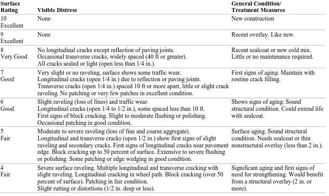
The Transportation Engineers Association of Missouri’s Pavement Surface Evaluation and Rating (PASER) was used as a benchmark to develop the pavement condition parameters by which the streets were assessed. Table 1 summarizes the rating system that was used.
Researchers collected data on the metropolitan St. Louis Central Corridor target areas using the following criteria:
Ward designation
Distance surveyed
Number of necessary repairs
Missouri PASER evaluation of roadway conditions
Cost associated with each repair
The number of necessary street repairs and costs of each repair were forecast using global
mapping technology and historical cost data. Since aldermen decide street asset allocations, costs were also allocated to each city ward district.
RESULTS
4
Table 1. Research rating system
Surface
Rating Visible Distress
General Condition/ Treatment Measures
10 Excellent
None New construction
9
Excellent
None Recent overlay. Like new.
8
Very Good
No longitudinal cracks except reflection of paving joints. Occasional transverse cracks, widely spaced (40 ft or greater). All cracks sealed or light (open less than 1/4 in.).
Recent sealcoat or new cold mix. Little or no maintenance required.
7 Good
Very slight or no raveling, surface shows some traffic wear.
Longitudinal cracks (open 1/4 in.) due to reflection or paving joints.
Transverse cracks (open 1/4 in.) spaced 10 ft or more apart, little or slight crack raveling. No patching or very few patches in excellent condition.
First signs of aging. Maintain with routine crack filling.
6 Good
Slight raveling (loss of fines) and traffic wear.
Longitudinal cracks (open 1/4 to 1/2 in.), some spaced less than 10 ft. First signs of block cracking. Slight to moderate flushing or polishing. Occasional patching in good condition.
Shows signs of aging. Sound
structural condition. Could extend life with sealcoat.
5 Fair
Moderate to severe raveling (loss of fine and coarse aggregate).
Longitudinal and transverse cracks (open 1/2 in.) show first signs of slight raveling and secondary cracks. First signs of longitudinal cracks near pavement edge. Block cracking up to 50 percent of surface. Extensive to severe flushing or polishing. Some patching or edge wedging in good condition.
Surface aging. Sound structural condition. Needs sealcoat or thin nonstructural overlay (less than 2 in.).
4 Fair
Severe surface raveling. Multiple longitudinal and transverse cracking with slight raveling. Longitudinal cracking in wheel path. Block cracking (over 50 percent of surface). Patching in fair condition.
Slight rutting or distortions (1/2 in. deep or less).
5
Surface
Rating Visible Distress
General Condition/ Treatment Measures
3 Poor
Closely spaced longitudinal and transverse cracks often showing raveling and crack erosion. Severe block cracking. Some alligator cracking (less than 25 percent of surface). Patches in fair to poor condition.
Moderate rutting or distortion (1 to 2 in. deep). Occasional potholes.
Needs patching and repair prior to major overlay. Milling and removal of deterioration extends the life of
overlay. 2
Very Poor
Alligator cracking (over 25 percent of surface). Severe distortion (over 2 in. deep).
Extensive patching in poor condition. Potholes.
Severe deterioration. Needs reconstruction with extensive base repair. Pulverization of old pavement is effective.
1 Failed
6
Table 2. Cost calculation of the repairs for the entire research area
Major Streets Sub-Streets Ward
Measured Distance
Missouri PASER
Evaluation Length Width Yards
Cost Associated with Repair
Martin Luther King Jr. (MLK) Dr. N. Jefferson Ave. to Beaumont St. 5 .14 miles 8-9 570 48 3040 $54,720.00
MLK Dr. Beaumont St. to Compton Ave. 6 .07 miles 7-8 3300 57 20,900 $376,200.00
Bell Ave. Cardinal Ave. to N. Garrison Ave. 19 .12 miles 8 480 36 1920 $34,560.00
School St. Compton Ave. to Cardinal Ave. 19 .13 miles 8-9 670 24 1790 $32,220.00
Franklin Ave. N. Leffingwell Ave. to T.E. Huntley Ave. 19 .37 miles 7 520 36 2080 $37,440.00
Franklin Ave. T.E. Huntley Ave. to Compton Ave. 19 .32 miles 6 1580 36 6320 $113,760.00
Delmar Blvd. N. Jefferson Ave. to Beaumont St. 5 .17miles 8-9 670 58 4320 $77,760.00
Delmar Blvd. Beaumont St. to Compton Ave. 19 .52 miles 7 2670 40 11,870 $213,660.00
Samuel Shepard Dr. N. Jefferson Ave. to N. Leffingwell Ave. 6 .25 miles 3 1270 36 5080 $91,440.00
Samuel Shepard Dr. N. Leffingwell Ave. to Compton Ave. 6 .38 miles 7 2150 36 8600 $154,800.00
Washington Ave. N. Jefferson Ave. to Compton Ave. 6 .67 miles 9 3300 60 22,000 $396,000.00
Locust St. N. Jefferson Ave. to Compton Ave. 6 .61 miles 7 3350 44 16,380 $294,840.00
Olive St. N. Jefferson Ave. to Compton Ave. 6 .63 miles 7 3420 76 2880 $51,840.00
Pine St. N. Leffingwell Ave. to Beaumont St. 6 .11 miles 8 510 40 2270 $40,860.00
Laclede Ave. N. Ewing Ave. to N. Garrison Ave. 19 .13 miles 7 775 42 3620 $65,160.00
N. Market St. N. Jefferson Ave. to N. Garrison Ave. 6 .43 miles 8 2200 80 19,560 $352,080.00
N. Market St. N. Garrison Ave. to Compton Ave. 6 .20 miles 7 1150 80 10,230 $184,140.00
N. Jefferson Ave. MLK Dr. to Market St. 19/5 0.7 miles 6 2260 80 23,650 $425,700.00
Beaumont St. MLK Dr. to Locust St. 5 .16 miles 3 1350 30 4500 $81,000.00
Beaumont St. Locust St. to Olive St. 19 .13 miles 6 620 24 1660 $29,880.00
Beaumont St. Olive St. to N. Market St. 19 .15 miles 8 830 32 2960 $53,280.00
N. Leffingwell Ave. MLK Dr. to Pine St. 19 .38 miles 8-9 2160 36 8640 $155,520.00
N. Ewing Ave. Olive St. to N. Market St. 19 .22 miles 7 1100 42 5140 $92,520.00
7
Major Streets Sub-Streets Ward
Measured Distance
Missouri PASER
Evaluation Length Width Yards
Cost Associated with Repair
T.E. Huntley Ave. Delmar Blvd. to Washington Ave. 19 .14 miles 6 630 36 2520 $45,360.00
T.E. Huntley Ave. Washington Ave. to Olive St. 19 .13 miles 7 640 36 2560 $46,080.00
Cardinal Ave. MLK Dr. to Bell Ave. 19 .09 miles 5-6 450 36 1800 $32,400.00
Cardinal Ave. Bell Ave. to Olive St. 19 .36 miles 7 2010 36 8040 $144,720.00
N. Garrison Ave. MLK Dr. to Delmar Blvd. 19 .22 miles 6 890 34 3370 $60,660.00
N. Garrison Ave. Delmar Blvd. to Washington Ave. 19 .12 miles 5 660 34 2500 $45,000.00
N. Garrison Ave. Washington Ave. to Olive St. 19 .15 miles 5 620 34 2350 $42,300.00
N. Garrison Ave. Laclede Ave. to N. Market St. 19 .08 miles 8 390 40 1740 $31,320.00
Compton Ave. MLK Dr. to Washington Ave. 19 .19 miles 4-5 2250 62 15,500 $279,000.00
Total Cost of Repair for the Whole Research Area $4,182,300.00
8
Table 3. Cost calculation for Ward 5 research area
Major Streets Sub-Streets Ward
Measured Distance
Missouri PASER
Evaluation Length Width Yards
Cost Associated with Repair
Martin Luther King Jr. (MLK) Dr. N. Jefferson Ave. to Beaumont St. 5 .14 miles 8-9 570 48 3040 $54,720.00
Delmar Blvd. N. Jefferson Ave. to Beaumont St. 5 .17 miles 8-9 670 58 4320 $77,760.00
Beaumont St. MLK Dr. to Locust St. 5 .16 miles 3 1350 30 4500 $81,000.00
Total Cost of Repair for the Ward 5 Research Area $213,480.00
The cost associated with the repairs is derived from the number of yards multiplied by the current cost on paving roads at $18 per yard (Source: St. Louis City Street Department)
Table 4. Cost calculation of the repairs for Ward 6 research area
Major Streets Sub-Streets Ward
Measured Distance
Missouri PASER
Evaluation Length Width Yards
Cost Associated with Repair
Martin Luther King Dr. (MLK) Beaumont St. to Compton Ave. 6 .07 miles 7-8 3300 57 20,900 $376,200.00
Samuel Shepard Dr. N. Jefferson Ave. to N. Leffingwell Ave. 6 .25 miles 3 1270 36 5080 $91,440.00
Samuel Shepard Dr. N. Leffingwell Ave. to Compton Ave. 6 .38 miles 7 2150 36 8600 $154,800.00
Washington Ave. N. Jefferson Ave. to Compton Ave. 6 .67 miles 9 3300 60 22,000 $396,000.00
Locust St. N. Jefferson Ave. to Compton Ave. 6 .61 miles 7 3350 44 16,380 $294,840.00
Olive St. N. Jefferson Ave. to Compton Ave. 6 .63 miles 7 3420 76 2880 $51,840.00
Pine St. N. Leffingwell Ave. to Beaumont St. 6 .11 miles 8 510 40 2270 $40,860.00
N. Market N. Jefferson Ave. to N. Garrison Ave. 6 .43 miles 8 2200 80 19,560 $352,080.00
N. Market N. Garrison Ave. to Compton Ave. 6 .20 miles 7 1150 80 10,230 $184,140.00
Total Cost of Repair for the Ward 6 Research Area $1,996,920.00
[image:22.792.67.685.260.465.2]9
Table 5. Cost calculation of the repairs for Ward 19 research area
Major Streets Sub-Streets Ward
Measured Distance
Missouri PASER
Evaluation Length Width Yards
Cost Associated with Repair
Bell Ave. Cardinal Ave. to N. Garrison Ave. 19 .12 miles 8 480 36 1920 $34,560.00
School Street Compton Ave. to Cardinal Ave. 19 .13 miles 8-9 670 24 1790 $32,220.00
Franklin Ave. N. Leffingwell Ave. to T.E. Huntley Ave. 19 .37 miles 7 520 36 2080 $37,440.00
Franklin Ave. T.E Huntley Ave. to Compton Ave. 19 .32 miles 6 1580 36 6320 $113,760.00
Delmar Blvd. N. Jefferson Ave. to Beaumont St. 19 .17miles 8-9 670 58 4320 $77,760.00
Laclede Ave. N. Ewing Ave. to N. Garrison Ave. 19 .13 miles 7 775 42 3620 $65,160.00
Beaumont St. Locust Ave. to Olive St. 19 .13 miles 6 620 24 1660 $29,880.00
Beaumont St. Olive St. to N. Market St. 19 .15 miles 8 830 32 2960 $53,280.00
North Leffingwell Ave. Martin Luther King Jr. (MLK) Dr. to Pine St. 19 .38 miles 8-9 2160 36 8640 $155,520.00
North Ewing Olive St. to N. Market St. 19 .22 miles 7 1100 42 5140 $92,520.00
T.E. Huntley Ave. MLK Dr. to Delmar Blvd. 19 .12 miles 4 640 36 2560 $46,080.00
T.E. Huntley Ave. Delmar Blvd. to Washington Ave. 19 .14 miles 6 630 36 2520 $45,360.00
T.E. Huntley Ave. Washington Ave. to Olive St. 19 .13 miles 7 640 36 2560 $46,080.00
Cardinal Ave. MLK Dr. to Bell Ave. 19 .09 miles 5-6 450 36 1800 $32,400.00
Cardinal Ave. Bell Ave. to Olive St. 19 .36 miles 7 2010 36 8040 $144,720.00
North Garrison MLK Dr. to Delmar Blvd. 19 .22 miles 6 890 34 3370 $60,660.00
North Garrison Delmar Blvd. to Washington Ave. 19 .12 miles 5 660 34 2500 $45,000.00
North Garrison Washington Ave. to Olive St. 19 .15 miles 5 620 34 2350 $42,300.00
North Garrison Laclede Ave. to N. Market St.. 19 .08 miles 8 390 40 1740 $31,320.00
Compton Ave. MLK Dr. to Washington Ave. 19 .19 miles 4-5 2250 62 15,500 $279,000.00
Total Cost of Repair for the Ward 19 Research Area $2,185,380.00
10
CONCLUSIONS
This research led to the completion of a relevant sustainable asset management transportation system model.
As a result of meetings with MoDOT and the St. Louis Street Department, the research team identified urban roadways surrounding the university as target areas for assessment. These assessments will assist in the construction of a financial model based on a need-projection-to-dollars-spent per fiscal year. This tool will aid local agencies with the identification and estimation of repair and maintenance of local roadways.
The project team collaborated with other research institutions in utilizing best practices to develop a sustainable, result-oriented solution model of transportation asset management. This technology-driven database model could potentially be used for a designated St. Louis