Institutional Report
The Institute of Seismological Research - A Premier Research Center
for Seismology in India
PALLABEE CHOUDHURY* and M RAVI KUMAR
Institute of Seismological Research, Department of Science and Technology, Government of Gujarat, Raisan, Gandhinagar 382 009, India
(Received on 10 April 2016; Accepted on 25 June 2016)
*Author for Correspondence: E-mail: pallabee.ch@gmail.com
Introduction
The tragedy caused by the January 26, 2001 Mw 7.8 earthquake marked a turning point in the disaster awareness and preparedness in the state of Gujarat, northwest India. This earthquake took the lives of 14,000 people, injured almost 170,000 or more, damaged 1.2 million houses and destroyed thousands of classrooms and numerous other essential facilities. The state of Gujarat has been aggressive in it’s reconstruction program and made immense progress within a short time span of the disaster. In view of the
India being the only institute fully dedicated to Earthquake Studies.
The vision of the institute is to understand the science of earthquake occurrences in intraplate and other regions and use this knowledge to save lives and minimize damage due to earthquakes. Currently, the strategic thrusts of the institute are:
l Earthquake monitoring through standardized surface observations. The use of modern digital technology in establishment of regional seismic networks including strong motion instruments, data acquisition and dissemination by exchange of catalogues, databases and bulletins from various sources.
l Developing new knowledge based techniques of probabilistic earthquake forecasting, micro and macro zoning of various vulnerable zones.
l Making recommendations relating to reduction of earthquake losses and using sound disaster mitigation policies and practices.
l Improve seismic safety and performance in built in environment especially in highly vulnerable urban areas.
l Undertaking steps and efforts to communicate earthquake science to engineers and use the knowledge base for creating public awareness by various methods in modern communication and media methodologies in society.
l Using multidisciplinary development in geological, geodetic, archaeological, physical sciences, geo-chronological and paleo-seismic studies for understanding the seismo-tectonic framework under plate tectonics theory and nonlinear dynamics.
l Accurate fault characterization, global and regional forecasting, fault system dynamics, earthquake source physics and ground motion prediction.
The current activities of ISR include
l Seismicity monitoring of the Gujarat State and the Narmada Dam area using a network of 60 broadband seismological stations. With the data received by VSAT and an auto location facility, the epicenter and magnitude of an earthquake are provided within minutes.
l Seismic microzonation and seismic hazard
studies for different cities to suggest seismic factor for earthquake-resistant designing of low to high-rise buildings in different areas.
l Understanding the physical processes related to earthquake genesis, with emphasis on intraplate regions.
l Long-term earthquake hazard assessment of different geological faults of Gujarat through a dense network of 22 GPS receivers, which detects minute deformation of 1 mm/year.
l Paleoseismology to unravel the record of historical earthquakes during the last 40,000 years.
l Palaeoclimatic research to decipher the climatic fluctuations in Gujarat during the last 10,000 years.
l Investigating the crustal and lithospheric structure and imaging the faults through multidisciplinary studies involving Passive Seismology, Gravity, Magneto-Tellurics and Resistivity.
l Earthquake precursory research using data from three multi-parametric geophysical observatories in Kachchh in which 11 different types of parameters are being observed.
l Assessment of Tsunami hazard and providing safety factors for Tsunami resistant designing of different types of structures, such as nuclear power plants, ports, jetties, oil pipelines and estimation of the arrival time and height of tsunami in the coastal areas.
l Creating awareness among people and allay their fear and anxieties about earthquakes. The ISR participates in mega events and demonstrates the online seismic data acquisition and location protocols, tsunami animation, earthquake effects on buildings and how to safeguard against them.
l Imparting training to students and guiding researchers. Every year ISR trains about 100 students from all over India by way of MSc/M Tech dissertation and PhD thesis.
and young scientists from the country and abroad contribute by presenting their valuable and state of the art research studies.
Noteworthy Contributions of ISR During 2011-2015
Highlights of the Research Outcomes During 2011-15 are given below:
Near Real Time Seismology : Seismicity in Gujarat
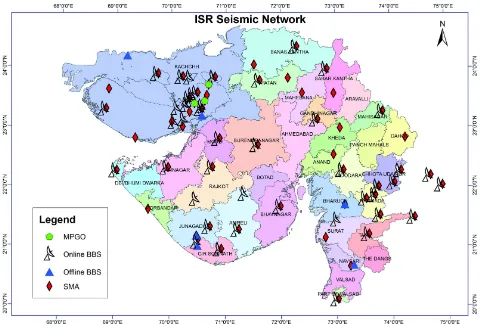
is monitored by a dense network of VSAT connected 60 broadband seismographs (BBS) (Fig. 1) which can detect earthquakes down to magnitude 2 occurring anywhere in the state or magnitude 4.5 anywhere in the world. This network is the densest in India. Earthquake parameters such as epicenter, magnitude and the affected areas with different intensities (damage potential) are informed within minutes through an auto-location program. Efforts are underway to reduce the detection time to seconds through establishment of an Earthquake Early
Warning system. In addition, a network of 55 strong motion accelerographs (SMA) is deployed for recording strong motion (Fig.1) near the epicenter and estimates the decay of strong ground motion in different parts of Gujarat. The regional data is augmented by real time data from global networks for locating earthquakes outside the network.
[image:3.612.67.548.390.719.2]ISR has bagged the National e-Governance Award-Gold for the year 2013-14, under a new category of ‘Outstanding e-Governance Initiatives by Academic and Research Institutions’ on “Effective Seismological Monitoring Through e-Governance to Save Lives and Damage due to Earthquakes”. The award was given by two Government of India ministries (i) Department of Administrative Reforms and Public Grievances (ii) Department of Electronics and Communication. The project was aimed at establishing an advanced infrastructure for seismic monitoring in Gujarat as a preparedness effort to save lives and damage to property from earthquakes. Through online functionality and auto location the
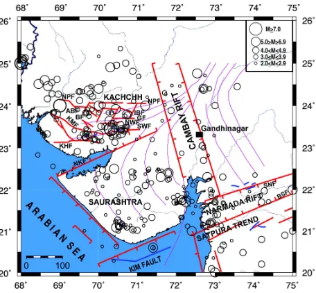
earthquake parameters are disseminated within minutes to state authorities, disaster management team and general public through SMS, email and website. The quick availability of earthquake information as well as potential damage map and shake map increase the ability and efficiency of decision makers and significantly reduces the time delay in start of the relief work. The reliable and immediate reports provided to media allay the anxiety / fear among the people. During the last 5 years nearly 9000 shocks of M0.5-5.1 have been recorded (Fig. 2). The data available on website is used nationwide for M. Tech. dissertations and PhD theses. The outcome is also in terms of tsunami alert; earthquake hazard and loss assessment, basic as well as applied research in seismology and engineering.
The knowledge of scaling relationships is crucial for both probabilistic and deterministic seismic hazard analysis. Such scaling relations allow estimating seismic energy or faulting parameters from measured seismic magnitude or moment. The seismic sources differ not only in their size and average slip, but stress conditions differ from region to region. Events of same seismic moment may release seismic energy that differs by 2 to 3 orders. The use of global scaling relations may not be appropriate. So, the site specific
regional scaling laws need to be developed and used for seismic hazard analysis. In this regard, regional scaling laws for Kachchh and Jungadh regions have been developed. Also, static stress drop and high frequency decay parameter ‘kappa’ have been estimated for Kachchh, Junagadh and Jamnagar regions of the state. In order to provide high quality data for source and earth structure studies, the Seismic Background Noise (SBN) levels should be as low as possible. The utility of seismic data is greatly increased when noise levels are reduced. A study of the SBN variations at 14 permanent BBS stations reveals large variations as a function of period, time and geographic location.
An attempt towards developing an Earthquake Early Warning System (EEWS) is made. The objective of EEWS is to forewarn urban centres a few seconds to tens of seconds prior to the arrival of destructive shear waves generated by a strong earthquake. These types of works are being initiated on a pilot basis in most countries of the world prone to strong earthquakes. ISR has developed a new methodology for rapid detection of events and estimation of the magnitude. Testing and validation of the relationships developed for Gujarat region with those of other countries is in process.
Basic Research
Paleoseismology is the study of prehistoric earthquakes, especially their location, time and size. This study is done by interpreting geological evidence created during individual paleoearthquakes and helps to understand the regional pattern of tectonic deformation and the long term behaviour of a specific fault. The strong earthquakes often leave geological evidences that are mainly related to surface faulting, folding or other deformation. A fault showing some activity in recent times is considered as active in terms of seismogenic potential and risk. Paleoseismology, Geomorphology and dating of recent tectonic features establish return periods of earthquakes and help in forecasting of earthquakes by determining ages of pre-historic earthquakes in Kachchh and rates of movements along geological faults.
[image:4.612.67.295.445.656.2]ISR has been doing such studies since the time of its establishment. In the last few years, fault lines have been mapped by geological and geophysical surveys as well as remote sensing and their relative
activeness has been assessed by dating of prehistoric tectonic episodes and paleoseismological investigations. Potential sites are identified with the help of remote sensing, geomorphometric studies, identification of signs of active movement on the sites, which indicate proximity to fault like pressure ridges and abrupt termination of river delta etc. Several geophysical surveys are also used to detect the subsurface faults. Analysis of samples collected from trenches is done in the OSL Lab for determining the ages of the sediments and how they were formed. The estimated deformation is corroborated with GPS and RTK results. The same study is extended to inner Kumaun Lesser Himalaya, Uttarakhand regions.
Approaches followed are as below:
l Integrated remote sensing (CORONA images, etc) and field surveys for identification of pressure ridges, drainage offsets and younger scarps.
l Geomorphic indices coupled with tectono-geomorphology and shallow subsurface geophysical surveys (GPR) for site selection.
l Trenching at shortlisted sites.
l Sedimentological, geochemical, mineral magnetic and chronological (OSL and 14C AMS) studies from fluvial sequences.
Allah Bund (ABF), Kutch Mainland (KMF), South Wagad (SWF), Island Belt (IBF) and Katrol Hill (KHF) Faults in Kachchh are found to be active as observed by Quaternary movements in trenches. This indicates that different faults are neotectonically active. Spatial variability in tectonic activity along KMF, KHF suggests that the central parts of these major faults are more active compared to the rest of the segments. Active fault studies along Gedi Fault, SWF shows its active nature during the Holocene Period.
ISR has performed seismic tomography studies on a local as well as regional scale, for Kachchh and Saurashtra regions of the Gujarat state as well as for the Himalayan region. ISR has evolved a technique of 3D fault mapping by Magnetotelluric investigations. Such surveys were done in the Kachchh region for identification of faults and in mainland Gujarat for locating geothermal sources. Broadband and long period Magnetotelluric (MT) investigations in the eastern part of the Kachchh basin are carried out to
map the deep electrical resistivity structure of the region. The aim of the study is to obtain 2-D/3-D geoelectric structure of the region, which will be integrated with the available seismological information to understand the migration of seismicity towards the north-eastern part of the basin, characteristics of various active faults, map the possible presence of deep partial melts/fluids in the region and understand their role in geodynamics of the region. To obtain information on the deeper structure, long period (4– 5 days, >1000 sec) data is acquired. Till date, ISR has acquired MT data at 150 locations in Kachchh. Delineation of faults and basement structure is also done using high resolution gravity surveys. So far, measurements have been made at about 1800 locations. Usually, the observations are made at 1 km interval, but for detection of faults, the interval is as small as 50 or 100m. The Bouguer Anomaly contour map was prepared at 1mgal interval for the Kachchh rift and Cambay basins and used to decipher the nature of known faults and some hidden faults. The coordinates of gravity stations obtained using RTK (GPS), with excellent accuracy.
Societal Research
University, Italy determines the ground motion based on the velocity structure of the entire path. This method has been used for Gujarat also and hazard is estimated.
Gujarat is the only state outside Himalayan and Sumatra-Andaman region which has a high seismic hazard due to earthquakes of magnitude 6 to 8. Even then, earthquake resistant high-rise buildings can be constructed with only 5-7% extra cost. Hence, the areas of rapid growth in Gujarat need to have prior information about earthquake safety factor to be considered. Moreover, due to different ground conditions or soil distribution with depth, seismic waves amplify differently for different heights of buildings, which has to be assessed. For this purpose, ISR is carrying out Seismic Microzonation of different cities and providing knowledge for seismic safety factor to be considered for each region of Gujarat for different heights of buildings. From this study, the structural response curves are determined which indicate acceleration for different natural periods in a 250-500m grid. This analysis involves geotechnical investigations through numerous boreholes and geophysical measurements of seismic wave velocities by seismic survey and PS logging. The liquefaction potential is also assessed. ISR has well-equipped geotechnical and geophysical labs for different lab and on-site tests. At micro level, earthquake hazard assessment is made for critical structures like Nuclear Power Plants, LNG Terminals and clusters of Skyscrapers. The institute has a unique expertise of carrying out all aspects of seismic microzonation.
To understand the tectonic process from deformational pattern of different fault systems in the Gujarat region, a dense network of geodetic grade Differential GPS stations is deployed. Since the year 2006, crustal deformation in Gujarat is being monitored by this network. A permanent network of 22 stations is being operated across different faults continuously till today. In addition, ISR is also running 11 GPS stations in campaign mode since 2006. The campaign mode surveys are being done twice a year. Mapping of paleo river-channels to find source of potable water with the aid of remote sensing and ground check by geological and geophysical surveys are also carried out. A horizon of potable water at 250 m depth below the layer of saline water in Ramgarh area near Jaipur, Rajasthan was discovered. Finding water in perched Rajasthan is like finding gold.
An effective and economical way of mapping shallow and deep soil shear wave velocity structure and estimate the sediment thickness is by Microtremor measurements. ISR has occupied 450 single Microtremeor sites in 8 districts of Gujarat and ground vibrational characteristics such as predominant frequency and amplification at these sites are estimated. Microtremor array measurements (MAM) were carried out over diverse geological formations and liquefaction sites in the Kachchh seismic zone of western India, which is host to the deadliest intraplate earthquake (Mw 7.7). The MAM were made using triangular arrays with sensors kept at 30-90 m radii. The 1-D shear wave velocity structure is determined by inversion. A good correlation between surface geology, resonant frequency, amplification and shear wave velocity is found. The ground vulnerability index values in the liquefied areas are found to be higher than those in the adjacent areas devoid of liquefaction. The results of microtremor analysis corroborate the observations from available geophysical, geological and borehole data.
Earthquake prediction research is being carried out through three Multi-parametric Geophysical Observatories (MPGO) in Kachchh region at Badargadh,Vamka and Desalpar (Fig.1). MPGO sites are in east and northeast of the aftershock zone of 2001 Bhuj earthquake (Mw 7.7), where the activity has migrated from the year 2006 onwards. Magnitude 5 earthquakes are still occurring in Kachchh occasionally and 70 shocks of magnitude “>1” are recorded on an average, per month. A Very Broadband Seismometer, Strong Motion Accelerograph, GPS and Radon recorders are installed at all the three sites. Fluxgate magnetometers are installed at Desalpar and Vamka. Only two water level recorders at Desalpar and Badargadh are installed at the confined aquifer zone and all the others are installed at shallow depth (below 5 m). Three Overhauser Magnetometers, three Declination/Inclination Magnetometers, three ULF Magnetometers are installed and recording data. Some anomalies in the magnetic, radon and gravity measurements are observed, correlated well with small to moderate earthquakes in the region.
residential complexes of Ahmedabad and Industrial sites in Kachchh. Seismic Microzonation of Areas of rapid growth like Dholera Special Investment Region where a number of cities with high-rise buildings, industrial hubs, an airport, a railway station are planned; cities like Gandhidham, Anjar, Gandhinagar and Ahmedabad are completed. ISR has also completed seismotectonic study of the site for LNG storage tanks in Mundra and a cluster of skyscrapers coming up in Gujarat International Finance Tec-city, which will have numerous buildings of 30 to 100 storeys. An important finding is that the low-rise buildings of 3-7 stories need to have 60-70% higher seismic factor than that recommended in the National Code, to avoid a disaster akin to that caused by the 2001 earthquake. ISR also estimated response spectra for nuclear power plants like Kakrapar and Rawatbhata and vulnerability assessment of ports of Gujarat. Study of surface deformation mapping using Differential SAR Interferometry and Earthquake Precursory studies in Kachchh is completed. A project on probabilistic analysis of seismic losses for urban areas and lifeline networks in Kachchh is being carried out in collaboration with the Karlsruhe Institute of Technology, Germany. The Govt. of Gujarat has planned to start a 1 MW Geothermal plant in the state for the first time. Through magnetotelluric investigations, ISR has identified two geothermal source zones at Chabsar and Tuwa. Through these commercial projects ISR is connecting research with lives and society as these works have societal importance and useful for saving lives and damage of properties due to earthquakes.
Research on Paleotsunami and Paleoclimate
ISR has initiated Paleotsunami studies in the west coast of India. Several large boulders are seen in the west coast which are possibly results of paleotsunami. The study aims to ascertain whether these are transported by a tsunami and if so, the source. Possibility of transportation by storm or by human activity is ruled out on the basis of the biological features present on the boulders and the physical or geomorphological field characteristics. The western coast of India is susceptible to tsunamis generated from multiple sources such as the Makran Subduction Zone (MSZ), Owen Fracture Zone (OFZ) and Carlsberg ridge. The work also tried to examine the possibility of an earthquake-cum-landslide generated
tsunami along the Owen Fracture zone. Although several studies from around the world have identified submarine landslides as a source of tsunami, there have been fewer studies documenting their implications in coastal hazard scenarios. Direction and force of transport of boulders were estimated which are lying along the coast. Measurements of the boulder dimensions, namely the (a) long, (b) medium and (c) shorter axis were recorded in addition to their distance from the high tide line. Also, their respective shape and orientation of along long axis were recorded. Samples of some boulders were collected and their density was measured in the laboratory of ISR. In order to evaluate the characteristics of waves responsible for the boulder deposits, evaluation of the minimum wave height capable of dislodging and transporting the boulders is first made followed by the estimation of the inundation distance of the waves. ISR first reported boulder sized palaeotsunami deposits along western coast of India during the last 3 ka with a wave height of 4 m along the Gujarat coast.
A broad correspondence of the monsoon reconstruction based on the valley-fill and the channel-fill deposits with that of the regional climate pattern indicates that the Kachchh peninsula in the western India responded in accordance with the regional climatic variability during the post-LGM period. A progressive strengthening of monsoon was observed between 17 and 12 ka and an overall strengthened monsoon with fluctuation is inferred between 12 ka and <8 ka. This was followed by a steady decline in monsoon strength during 8 ka to 3 ka. Presence of the younger fill sequences proximal to the present day river channel dated to ~1 ka indicates a short-lived phase of renewed and strengthened Indian Summer Monsoon before the onset of present day aridity.
aggradation/incision phases in the Lotia River in the eastern segment of the Northern Hill Range (NHR) of the Kachchh Peninsula, which drains from Mesozoic rocks before cutting through the Kachchh Mainland Fault (KMF) to finally debouch in the Banni Plains. Reconstruction based on tectonic geomorphology, sedimentology, sediment geochemistry, mineral magnetics, and OSL chronology suggests the fluvial response to monsoon variability archived during the last 15 ka. The time frame was also marked by incision enhanced by uplift along the KMF, which led to strath terrace formation. The accommodation space thus created was filled by the aggradational event between 14.8 ka and 10.6 ka. Sedimentological and geochemical parameters also suggested that the time period between 12.5 ka and 11.5 ka showed a decline in monsoon strength, which coincides with ‘Younger Dryas’. Sediments spanning between 10.6 ka and 7.8 ka are absent from the archive, which is most likely that the manifestation of the early Holocene optimum that led to severe erosional processes. Based on the OSL chronology of bedrock strath terrace, ISR reported a minimum uplift rate of 1.04 mm/a for the eastern KMF during the Late Pleistocene-Holocene period, hinting at the seismically active nature of KMF during this period. The terrace formation in eastern Northern Hill Range is chiefly regulated by tectonic uplifts along the KMF.
Future Outlook
l To pursue research in exploration for minerals and ground water using interdisciplinary approaches involving terrestrial and airborne observations.
l To undertake application of high performance computational seismology, modeling and interpretations, including use of artificial intelligence tools for visualization of earth processes, delineating hydrocarbon reservoirs and other resources for sustainable development.
l To undertake research in Earthquake
Mechanics and Engineering for development of new concepts, new algorithms and numerical simulation of geological structures. The chaotic nature of brittle deformation and detection of various kinds of precursory signals.
l To undertake, promote and encourage various levels of long term original research, education and training in pure and applied seismology. The focus will be on developing earthquake system science to understand origins, properties and consequences of earthquakes.
l To evolve and participate in the development of seismic policies, seismology syllabus in academic institutions, study tours at regional, national and international organizations so as to develop quantitative understanding of limits of earthquake predictability and explain concerns to public institutions.
Publications
Aier I, Luirei K, Bhakuni S S, Thong G T and Kothyari G C (2011,) Geomorphic evolution of Medziphema intermontane basin and Quaternary deformation in the schuppen belt, Nagaland, NE India Zeitschrif fur
Geomorphologie 55 247-265
Basavaiah N, Mahesh Babu J L V, Gawali P B, Nagakumar K Ch V, Demudu G, Prizomwala S P, Hanamgond P T and Rao K N (2015) Late Quaternary environmental and sea level changes from Kolleru Lake, SE India: Inferences from mineral magnetic, geochemical and textural analysis
Quaternary International 371 197-208
Bayrak Y, Yadav R B S, Kalafat D, Tsapanos T M, Çýnar H, Singh A P, Bayrak E, Yýlmaz Þ, Öcal F and Koravos G (2013) Seismogenesis and earthquake triggering during the
Van (Turkey) 2011 seismic sequence Tectonophysics 601 163-176
Bhakuni S S, Luirei K and Kothyari G C (2013) Neotectonic Fault in the middle part of Lesser Himalaya, Arunachal Pradesh: a study based on structural and morphotectouic analyses Himalayan Geology 34 57-64
Bhattarchya F, Rastogi B K and Kothyari G C (2013) Morphometric evidences of Seismicity around Wagad and Gedi Faults, Eastern Kachchh, Gujarat Journal of
Geological Society of India 81 113-121
Bhattacharya F, Rastogi B K, Mgangom M, Thakkar M G and Patel R C (2013) Late Quaternary climate and seismicity in the Katrol Hill Range, Kachchh, Western India Journal
of Asian Earth Sciences 73 114-120
N (2014) Fluvial landforms and their implication towards understanding the past climate and seismicity in the northern Katrol Hill range, Western India Quaternary
International DOI: 10.1016/j.quaint.2014.03.002
Chopra S, Chang T M, Saikia S, Yadav R B S, Choudhury P and Roy K S (2014) Crustal structure of the Gujarat region, India: New constraints from the analysis of teleseismic receiver functions Journal of Asian Earth Sciences 96 237-254
Chopra S and Choudhury P (2011) A study of response spectra for different geological conditions in Gujarat, India Soil
Dynamics and Earthquake Engineering 3 1551-5164
Chopra S, Kumar D and Rastogi B K (2011) Attenuation of high frequency P and S waves in the Gujarat Region, India Pure
and Applied Geophysics 168 797-813
Chopra S, Kumar D, Rastogi B K, Choudhury P and Yadav R B S (2012) Deterministic seismic scenario in Gujarat, India
Natural Hazards 60 517-540
Chopra S, Kumar D, Rastogi B K, Choudhury P and Yadav R B S (2013) Estimation of site ampliûcation functions in Gujarat region, India Natural Hazards 65 1135-1155
Chopra S, Kumar D, Rastogi B K, Choudhury P and Yadav (2013) Estimation of seismic hazard in Gujarat region, India Natural Hazards 65 1157-1178
Chopra S, Kumar D, Choudhury P and Yadav R B S (2012) Stochastic Finite Fault Modeling of Mw 4.8 Earthquake in Kachchh, Gujarat, India Journal of Seismology 16 435-449
Chopra S, Sharma J, Sutar A and Bansal B K (2014) Estimation of Source Parameters of Mw 6.9 Sikkim Earthquake and Modeling of Ground Motions to Determine Causative Fault Pure and Applied Geophysics DOI: 10.1007/s00024-013-0722-6
Choudhury P, Catherine J K, Gahalaut V K, Chopra S, Dumka R and Roy K S (2013) Post Seismic deformation associated with the 2001 Bhuj earthquake Natural Hazards 65 1109-1118
Choudhury P, Chopra S, Roy K S and Rastogi B K (2014) A review of strong motion studies in Gujarat State of western India Natural Hazards 71 1241-1257
Dumka R K, Kotlia B S, Kumar K, Satyal G and Joshi L (2014) Crustal deformation revealed by GPS in Kumaun Himalaya
Journal of Mountain Science 11 41-50
Dumka R K, Kotlia B S, Miral M S, Joshi L M, Kumar K and Sharma A K (2013) Global Positioning System (GPS) derived Recession Rate in Milam Glacier, Higher Central Himalaya, India, Research Inventory: International
Journal of Engineering and Science 2 58-63
Gandhi D, Prajapati P, Prizomwala S P, Bhatt N and Rastogi B K (2014) Delineating the spatial variability in Neotectonic Activity along the Southwestern Saurashtra using Remote Sensing Approach Zeitschrif fur Geomorphologie DOI: 10.1127/0372-8854/2014/0122
Gupta A, Sutar A, Chopra S, Kumar S and Rastogi B K (2012) Attenuation Characteristics of coda waves in Mainland Gujarat (India) Tectonophysics 530 264-271
Gupta S, Mahesh P, Sivaram K and Rai S S (2012) Active fault beneath the Tehri dam, Garhwal Himalaya- seismological evidence Current Science 103 1343-1347
Jade S, Mukul M, Gaur V K, Kumar K, Dumka R, Satyal G, Saigetth J, Ananda M B and Kumar D (2014) Contemporary deformation in the Kashmir-Himachal, Garhwal-Kumaun Himalaya: insights from 1995-2008 GPS time series Journal of Geodesy 1 1-9
Jaiswal R K, Singh A P, Rastogi B K and Murty T (2011) Aftershock sequences of two great Sumatran earthquakes of 2004 and 2005 and simulation of the minor tsunami generated on September 12, 2007 in the Indian Ocean and its effect Natural Hazards 57 7-26
Jaiswal R K and Rastogi B K (2012) Next Tsunami in India in the Arabian Sea? Journal of Geophysics 33 111-115
Joshi A, Kumar A, Mohan K and Rastogi B K (2013) Hybrid attenuation model for estimation of peak ground acceleration in the Kutch region, India Natural Hazards 68 249-269
Joshi S and Kothyari G C (2015) Possibility of induced seismicity in Pancheshwar dam site on Kali river, Uttarakhand
International Journal of Engineering Research and Technology 4 380-383
Kothyari G C (2014) Morphometric analysis of Tectonically active Pindar and Saryu River Basins, Central Kumaun Himalaya, India Zeitschrif fur Geomorphologie DOI:10.1127/zfg/2014/0162
Kothyari G C and Juyal N (2013) Implication of Fossil Valleys and Associated Epigenetic Gorge in part of the Central Himalaya Current Science 105 383-388
Kothyari G C and Rastogi B K (2013) Tectonic Control on drainage network evolution in the Upper Narmada Valley Implication to Neotectonics Geography Journal DOI: 10.1155/2013/ 325808
Kothyari G C, Pant P D and Luirei K (2012) Landslides and Neotectonic Activities in the Main Boundary Thrust (MBT)zone: Southeastern Kumaun, Uttarakhand Journal
of Geological Society of India 79 1-10
Fault zone in Kachchh Rift Basin, Western Peninsular India Journal of Comunicações Geológicas 102 DOI: CG13-24-2211
Kumar S, Chopra S, Choudhury P, Singh A P, Yadav R B S and Rastogi B K (2012) Ambient noise levels in Gujarat state (India) seismic network, Geomatics Natural Hazards and
Risk 1-13
Kumar S, Kumar D and Rastogi B K (2014) Source Parameters and Scaling Relations for Small earthquakes in the Kachchh Region of Gujarat, India Natural Hazards DOI 10.1007/ s11069-014-1133-4
Luirei K, Bhakuni S S and Kothyari G C (2015) Drainage response to active tectonics and evolution of tectonic geomorphology across the Himalayan Frontal Thrust, Kumaun Himalaya Geomorphology 239 58-72
Luirei K, Bhakuni S S, Kothyari G C, Tripathi K and Pant P D (2015) Quaternary extensional and compressional tectonics revealed from Quaternary landforms along Kosi River valley, outer Kumaun Lesser Himalaya, Uttarakhand
International Journal of Earth Sciences DOI: 10.1007/
s00531-015-1204-0
Luirei K, Bhakuni S S, Suresh N, Kothyari G C and Pant P D (2014) Tectonic Geomorphology and Morphometry of the frontal part of Kumaun Sub-Himalaya: Appraisal of tectonic activity Zeitschrif fur Geomorphologie DOI: 10.1127/0372-8854/2014/0134
Mahesh P, Catherine J K, Gahalaut V K, Kundu B, Ambikapathy A, Bansal A, Premkishore L, Narsaiah M, Ghavri S, Chadha R K, Choudhary P, Singh D K, Singh S K, Kumar S, Nagarajan B, Bhatt B C, Tiwari R P, Kumar A, Kumar A, Bhu H and Kalita S (2012) Rigid Indian plate: Constraints from GPS measurements Gondwana Research 22 1068-1072
Mahesh P, Gupta S, Rai S S and Sarma R (2012) Fluid driven earthquakes in the Chamoli region, Garhwal Himalaya: evidence from local earthquake tomography Geophysical
Journal International 191 1295-1304
Mahesh P, Rai S S, Sivaram K, Paul A, Gupta S, Sarma R and Gaur V K (2013) One dimensional reference velocity model and precise locations of earthquake hypocenters in the Kumaon-Garhwal Himalaya Bulletin of Seismological
Society of America 103 p.328-339
Mishra O P, Singh A P, Kumar D and Rastogi B K (2014) An insight into crack density, saturation rate, and porosity model of the 2001 Bhuj earthquake in the stable continental region of western India Journal of Asian Earth Science 83 48-59
Mohan K (2014) Seismic-Hazard Assessment in the Kachchh
Region of Gujarat (India) through Deterministic Modeling Using a Semi-Empirical Approach Seismological Research
Letters 85 117-125
Mohan K and Joshi A (2011) Role of attenuation relationship in shaping the seismic hazard Natural Hazards 60 649-670
Mohan K and Joshi A (2013) Simulation of Strong ground motion due to Great earthquake in the central seismic gap region of Uttarakhand Himalaya Natural Hazards 69 1733-1749
Mohan K, Rastogi B K and Chaudhary P (2015) Magnetotelluric studies in the epicenter zone of 2001, Bhuj earthquake Journal of Asian Earth Science 98 75-84
Patel V M, Dholakia M B and Singh A P (2014) Emergency preparedness in the cast of Makran tsunami: a case study on tsunami risk visualization for the western parts of Gujarat, India, Geomatics Natural Hazards and Risk DOI: 10.1080/19475705.2014.983188
Patel V M, Patel H S and Singh A P (2011) Comparative Study of Earthquake and Tsunami Loading on Vertical Evacuation Structure at Dwaraka International Journal of Earth Science
and Engineering 4 659-668
Pavankumar G, Manglik A and Thiagrajan S (2014) Crustal geoelectric structure of the Sikkim Himalaya and adjoining Gangetic basin Tectonophysics 637 238-250
Phartiyal B, Kaira R and Kothyari G C (2015) Late-Quaternary geomorphic scenario due to changing depositional regimes in the Tangtse valley, Trans-Himalaya, NW India
Palaeogeography, Palaeoclimatology, Palaeoecology 422
11-24
Phartiyal B and Kothyari G C (2012) Impact of Neotectonics on drainage network evolution reconstructed from morphometric indices: case study from NW Indian Himalaya Zeitschrif fur Geomorphologie 56 121-140
Phartiyal B, Sharma A and Kothyari G C (2013) Damming of River Indus during Late Quaternary in Ladakh region of Trans Himalaya, NW India: Implications to Lake formation-climate and tectonics Chinese Science Bulletin 58 142-155
Prabhin S, Rajshekhar C, Sant D A and Krishnan K (2012) Late Holocene Storm Records from Lower Reaches of Narmada Valley, western India Journal of Geological Society of India 80 403-408
Prabhin S, Sant D A, Krishnan K and Rangarajan G (2012) High resolution facies record on Late Holocene Flood plain sediments from Lower Reaches of Narmada Valley, Western India Journal of Geological Society of India 79 41-52
Surface-Wave Dispersion Bulletin of the Seismological Society of
America 101 859-865
Prajapati S, Suresh G and Bhattacharya S N (2011) Crustal Structure of the northwestern deccan Volcanic Provinces, India and Adjoining Continental Shelf through Inversion of Observed Surface Wave Dispersion Bulletin of the
Seismological Society of America 101 1106-1113
Prizomwala S P, Bhatt N and Basavaiah N (2014) Understanding the sediment routing system along the Gulf of Kachchh coast, Western India: Significance of small ephemeral rivers
Journal of Earth System Science 123 121-133
Prizomwala S P, Bhatt N P and Basavaiah N (2014) Sediment fluxes from a dry land fluvial regime: An example from Rukmawati river basin, Kachchh, western India
International journal of Sediment Research 29 109-119
Prizomwala S P, Gandhi D, Ukey V M, Bhatt N and Rastogi B K (2015) Coastal Boulders as evidences of high-energy marine events from Diu Island, west coast of India: storm or palaeotsunami Natural Hazards 75 1187-1203
Rao C N, Rao N P C and Rastogi B K (2013) Evidence for Right-Lateral Strike-Slip Environment in the Kutch basin of Northwestern India from Moment Tensor Inversion studies
Journal of Asian Earth Science 64 158-167
Rao K M, Kumar M R and Rastogi B K (2015) Crust beneath the northwestern Deccan volcanic, India: Evidence for uplift and magmatic underplating, Journal of Geophysical Research Solid Earth 120 1-21
Rao K M, Kumar M R, Singh A and Rastogi B K (2013) Two distinct shear wave splitting directions in the northwestern Deccan Volcanic Province Journal of Geophysical Research,
Solid Earth 118 1-13
Rana N, Bhattacharya F, Basavaiah N, Pant R K and Juyal N (2013) Paleoseismic implications of Soft Sediment Deformation structure in the Tethyan Himalaya, Uttrakhand, India Tectonophysics 592 165-174
Rastogi B K (2012) Indo-US Workshop on Intraplate Seismicity
Journal of Geological Society of India 79 316-317
Rastogi B K (2012) Comments on the paper by Bilham and Gaur
Current Science 103 1-2
Rastogi B K (2013) Report on 2nd International Symp. “Advances
in Earthquake Sc.” (AES-2013) and Intl. School on “Use of e-infrastructures for Advanced Seismic Hazard Assessment in Indian Sub-continent Journal of Geological
Society of India 81 724-726
Rastogi B K, Aggrawal S K, Rao N and Choudhury P (2013) Triggered migrated seismicity due to the 2001 Mw7.6 Bhuj earthquake, Western India Natural Hazards 65 1085-1107
Rastogi B K, Kayal J R and Harinaryana T (2013) Introduction to the special volume on Bhuj earthquake Natural Hazards 65 1023-1025
Rastogi B K, Kumar S and Aggrawal S K (2013) Seismicity of Gujarat Natural Hazards 65 1027-1044
Rastogi B K, Kumar S, Aggrawal S K, Mohan K, Rao N, Rao N P and Kothyari G C (2013) The October 20, 2011 Mw 5.1 Talala Earthquake in the Stable Continental Region of India
Natural Hazards 65 1197-1216
Rastogi B K, Singh A P, Sairam B, Jain S K, Kaneko F, Segawa S and Matsuo J (2011) The Possibility of Site Effects: The Anjar Case, following Past Earthquakes in Gujarat, India,
Seismological Research Letters 82 59-68
Sairam B, Rastogi B K, Aggarwal S, Chauhan M and Bhonde U (2011) Seismic site characterization using Vs30 and site amplification in Gandhinagar region, Gujarat, India,
Current Science 100 754-761
Sati S P, Ali S N, Rana N, Bhattacharya F, Bhushan R, Shukla A D, Sundriyal Y P and Juyal N (2014) Timing and extent of Holocene glaciations in the monsoon dominated Dunagiri valley (Bangni glacier), Central Himalaya, India Journal of
Asian Earth Sciences 91 125-136
Sharma B, Kumar D, Teotia S S, Rastogi B K, Gupta A K and Prajapati S (2011) Attenuation of Coda Wave in the Saurashtra Region, Gujarat India Pure and Applied
Geophysics 169 89-100
Sharma B and Rastogi B K (2014) Spatial distribution of scatterers in the crust of Kachchh region, Western India by inversion analysis of coda envelopes Disaster Advances 7 84-93
Sharma J, Chopra S and Roy K S (2014) Estimation of Source parameters, Quality factor (Qs) and Site characteristics using accelerograms: Uttarakhand Himalaya region Bulletin
of Seismological Society of America 104 360-380
Singh A P (2015) Seismic Hazard Evaluation in Anjar City Area of Western India: Microtremor Array Measurement Soil
Dynamics and Earthquake Engineering DOI: 10.1016/
j.soildyn.2015.01.009
Singh A P, Annam N and Kumar S (2014) Assessment of predominant frequencies using ambient vibration in the Kachchh region of western India: implications for earthquake hazards Natural Hazards DOI: 10.1007/ s11069-014-1135-2
Singh A P and Mishra O P (2015) Seismological evidence for Monsoon induced micro to moderate earthquake sequence beneath the 2011 Talala, Saurashtra earthquake, Gujarat, India Tectonophysics 661 38-48
(2012) Spatial Variation of the Aftershock Activity across the Kachchh Rift Basin and Its Seismotectonic Implications
Journal of Earth System Science 121 439-451
Singh A P, Mishra O P, Rastogi B K and Kumar D (2011) 3-D seismic structure of the Kachchh, Gujarat, and its implications for the earthquake hazard mitigation Natural
Hazards 57 1-23
Singh A P, Mishra O P, Rastogi B K and Kumar S (2013) Crustal heterogeneities beneath the 2011 Talala, Saurashtra earthquake, Gujarat, India source zone: Seismological evidence for neo-tectonics Journal of Asian Earth sciences 62 672- 684
Singh A P, Mishra O P, Yadav R B S and Kumar D (2012) A new Insight into Crustal Heterogeneity beneath the 2001 Bhuj Earthquake Region of Northwest India and its Implications for Rupture Initiations Journal of Asian Earth sciences 48 31-42
Singh A P, Murty T S, Rastogi B K and Yadav R B S (2012) Earthquake generated tsunami in the Indian Ocean and probable vulnerability assessment for the east coast of India Journal of Marine Geodesy 35 49-65
Singh A P, Roy I G, Kumar S and Kayal J R (2013)Seismic source characteristics in Kachchh and Saurashtra regions of western India: b-value and fractal dimension mapping of aftershock sequences Natural Hazards DOI: 10.1007/ s11069-013-1005-3
Singh A P, Singh R P, Raju P V S and Bhatla R (2011) The impact of three different cumulus parameterization schemes on the Indian summer monsoon circulation International
Journal of Ocean and Climate Systems 21 27-44
Simha C P, Kumar G P, Mahesh P, Navneeth A, Rao K M, Rastogi B K, Sridhar V N and Shukla A K (2014) Ionospheric disturbances with the time of Occurrence, magnitude and location of the earthquakes (M6.5) near the Indian sub-continent Natural Hazards 70 935-940
Sridhar A, Chamyal L S, Bhattacharya F and Singhvi A K (2013) Early Holocene fluvial activity from the sedimentology and paleohydrology of gravel terrace in the semi-arid Mahi River Basin, India Journal of Asian Earth Sciences 66 240-248
Yadav R B S, Bayrak Y, Tripathi J N, Chopra S, Singh A P and Bayrak E (2011) A Probabilistic Assessment of Earthquake Hazard Parameters in NW Himalaya 2 and the Adjoining Regions Pure and Applied Geophysics 169 1619-1639
Yadav R B S, Papadimitriou E E, Karakostas V G, Shanker D, Rastogi B K, Chopra S, Singh A P and Kumar S (2011) The 2007 Talala, Saurashtra, western India earthquake sequence: Tectonic implications and seismicity triggering Journal of
Asian Earth Sciences 40 303-314
Yadav R B S, Tripathi J N, Rastogi B K, Das M C and Chopra S (2011) Probabilistic assessment of earthquake recurrence in northeast India and adjoining regions Pure and Applied