THE RESEARCH OF DEM DATA COMPRESSING ARITHMETIC
IN HELICOPTER NAVIGATION SYSTEM
Gao Bo, Wan Fangjie
Mailbox 1001, 860 Part, Zhengzhou, Henan, China 450002 [email protected]
The helicopter is an important equipment to perform succor, public security patrol, fire fighting and transportation etc. It has the characteristic of high maneuverability, so the auto navigation system is very important. But lots of helicopter also is using papery map to navigation. So the navigation system is necessary to study.
1. Difficulty and characteristic in system design
The helicopter Navigation System is running in the embedded equipment, its resource is very limited, so it is different as normal GIS. In system designing, it must be taken into account, such as using resource reasonable, reducing resource wastage, improving efficiency etc. In the software designing, it is necessary to design a spatial model. a corresponding data structure and rapid spatial analysis arithmetic. In one word, the design of HNS (Helicopter Navigation System) should have following difficulty and characteristic:
z Compare with the desktop GIS, the speed of embedded CPU in HNS is very slow, and storage space is small, but also need to process a mass of data.
z HNS terminal should be small, light, aseismatic and low power.
z HNS should provide real time terrain analysis, map display and flight warning. z The circumstance of HNS working is very bad, to ensure the data’s reliability, the
solid-state electron disk should be adopted. Because the IO speed of electron disk is very slow, so the efficiently data compressing arithmetic and optimizing data structure.
2. The design of system function z Map browsing
The HNS can carry on zooming in, zooming out and roaming etc. It can shows various information that the flight needs on the screen, such as current longitude and latitude, altitude, time, the distance to destination and anticipating arriving time etc.
The check point can be selected from map or input longitude and latitude (or Gauss coordinate) directly. The course can be edited, deleted, copied and reversed.
z Positioning and navigating
Through uniting the GPS and Radar, current position of helicopter can be displayed at the corresponding position in map. When the course is set, the pilot can select head-up or north-up and destination-up navigation. Moreover, if the helicopter is aberrancy, the system will automatically prompt.
z Information querying
Supporting by the foundation data, information querying can be carried on, such as airport index (for example the position of a certain airport, the nearest airport etc.), and various mark information index.
z Map marking
The mark can be carried out easily that based on spatial information (such as airport or check point), and the mark information can be shared.
z Flight recording
The flight track can be recorded, and can be playback.. System provides various record methods, such as whole course record, stretch record, fixed length record etc.
z Flight warning
When the helicopter flies in the low altitude, there has something is higher than the helicopter, such as mountain peak, tree etc. To ensure flight safety, system should give early-warning signal to these dangerous districts.
When opening early-warning function, according to current position and screen rotation angle, system pick-up DEM data from memory that fit the screen scope, and do the data linear transforming, then fill different warning color in the corresponding position in the screen according to the difference from the safe altitude.
z terrain analyzing
System can carry on terrain analysis. (Such as measure the altitude, slope, azimuth angle and visibility analysis etc.)
3. DEM data compressing and decompressing
It is an important function that warning to the pilot in flight according current altitude. Flight warning is based on the DEM data. Because of the small storage space and slow running speed, the suitable arithmetic to compress DEM data must be designed. To choose a suitable arithmetic, this paper studies the mature compressing technologies, and compares them from compressing rate, processing speed, and precision loss. The arithmetic includes LZW, LZARI, JPEG, JPEG12bit and Microwave.
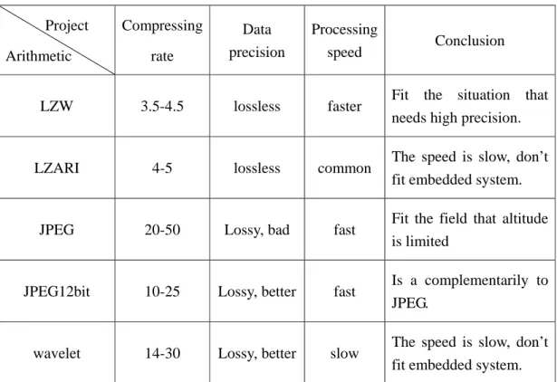
Project Arithmetic Compressing rate Data precision Processing speed Conclusion
LZW 3.5-4.5 lossless faster Fit the situation that needs high precision.
LZARI 4-5 lossless common The speed is slow, don’t fit embedded system.
JPEG 20-50 Lossy, bad fast Fit the field that altitude is limited
JPEG12bit 10-25 Lossy, better fast Is a complementarily to JPEG.
wavelet 14-30 Lossy, better slow The speed is slow, don’t fit embedded system. Table 1: The comparison of compressing arithmetic
According to the experimentation data, LZW, JPEG and JPEG12bit are suitable in HNS. In the arithmetic, JPEG is fastest, LZW is highest precision. The user can select different arithmetic or combination them according to the needs of precision and speed.
This paper brings forward an adaptive compressing arithmetic to compress DEM data. Figure 1 is the flow chart.
The original data blocks are processed by JPEG unit firstly, then judge the precision whether reach the users demand. If not, the JPEG12bit will be used. Uniformity, if JPEG12bit can not reach the application, then the LZW will be used; the LZW is a lossless arithmetic.
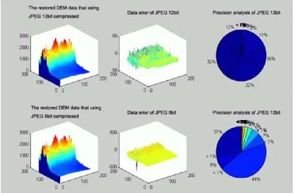
Because the JPEG arithmetic is quickly and the compressing rate is very high, but in the meantime, it may produce a very big error, so when it is chosen as basic arithmetic, the large error fields should using different arithmetic. JPEG12bits is an excellent replacement algorithm when the precision of JPEG algorithm cannot reach needs. Generally, when the algorithm changes to JPEG12bit, the error has been able to reach the usage demand after compressing, and don't need to carry on the error analysis secondly and don’t need to use LZW. Figure 2 is the comparison of JPEG12bit and JPEG8bit.
Figure 1: The flow chart of adaptive compressing arithmetic
It can be adopt the following way to the combination of JPEG and JPEG12bits:
First: if the quantization coefficient is big than 0.5 when adjust the normalization coefficient, then do the first compressing that using JPEG. When the first compression finished, compare the compressed data with original data and calculate the error distributing, if it isn't reached the condition of adjustment of arithmetic, then reserve the first compressed data and proceed with the data compressing until finished. If it is reached the condition of adjustment of arithmetic, such as the number of altitude point that mean square error exceeds 20m in 10000 DEM data, then the compression arithmetic is changed to do the second compressing.
Second: if the quantization coefficient is less than 0.5, then the JPEG12bits compression arithmetic is used directly.
The scope of DEM data that using in HNS is 5630*5001. According to its memory size and processing ability, the buffer size is 1000*1000. In the actual experiment environment, the result is: The average updating time is 170 seconds; the maximum data processing time is 2.3 seconds, the shortest is 1.1 second, average time is 1.4 seconds; the average system occupancy less than 1%; the terrain analyzing time that using original data is 20 seconds, and now is less than 1 second.
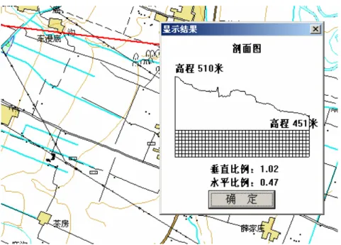
Figure 4: Section plane in terrain analyzing
In real using, this adaptive compressing and decompressing algorithm can reach the real time demand of HNS.
Reference:
1. G. Mandyam Lossless image compression using the Disrete Cosine Transform Journal of Visual Communication and Image Representation 1997 8 1 21-26
2. Michael D. Adams: Coding of Still Pictures ISO/IEC JTC 1/SC 29/WG 1 2001. 12. P18
3. A.N. Skodras, C.A. Christopoulos and T. Ebrahimi, "JPEG2000: The upcoming still image compression standard", Proc. 11th Portugese Conference on Pattern Recognition , Porto, Portugal, pp. 359-366, May 2000.
4. ISO/IEC JTC 1/SC 29/WG 1, ISO/IEC FCD 15444-1: Information Technology - JPEG2000 Image Coding System: Core Coding System [WG 1 N 1646], March 2000, (http://www.jpeg.org/FCD15444-1.htm).
5. T.A. Welch, "A Technique for High-Performance Data Compression", IEEE Computer, pp. 8-19, June 1984.