http://www.sciencepublishinggroup.com/j/ajtte doi: 10.11648/j.ajtte.20190402.13
ISSN: 2578-8582 (Print); ISSN: 2578-8604 (Online)
Climate Change Evolution and Indigenous Methods of
Flood Control in the Upper Nun Valley of Cameroon
Cordelia Givecheh Kometa
Department of Topography and Real Estate Management, Higher Technical Teachers’ Training College, University of Buea, Kumba, Cameroon
Email address:
To cite this article:
Cordelia Givecheh Kometa. Climate Change Evolution and Indigenous Methods of Flood Control in the Upper Nun Valley of Cameroon.
American Journal of Traffic and Transportation Engineering. Vol. 4, No. 2, 2019, pp. 56-66. doi: 10.11648/j.ajtte.20190402.13
Received: March 8, 2019; Accepted: April 23, 2019; Published: May 26, 2019
Abstract:
This study discusses the evolution of climate change and the use of indigenous methods of flood control in the Upper Nun Valley of Cameroon. The local farmers of the Ndop plain have developed and implemented extensive indigenous farming systems as adaptation strategies to reduce the vulnerability of climate variability over the years. However, these indigenous methods of flood control have not been sustainable enough to guard against severe flood incidences in the Ndop Plain as a result of climate change impact. This paper examines climate change evolution in the region and highlights some indigenous adaptation strategies practised in the Upper Nun Valley and the benefits of integrating such indigenous knowledge into formal climate change adaptation strategies. To ensure stability in food production and sustain food sufficiency in areas where local economies entirely depend on farming and the natural state of the environment, it is important to investigate the indigenous strategies put in place and the extent to which they combat floods in the Ndop Plain. Field surveys, focus group discussions, interviews, participant observation methods and secondary sources were used to collect data from selected villages where rice cultivation and market gardening products are on the increase. Based on climatic data for the region, the simple forecasting method using the forecasting line was used to predict future changes in climatic conditions for the region and the extent to which they may cause floods. The data collected were analyzed in both qualitative and quantitative terms to provide information for the discussion. The results reveal that changes in temperature and rainfall have altered the climatic conditions of the region leading to increased flood incidences in the Plain. The paper posited that a sustainable adaptation mechanism should take into consideration the widening of the drains as well as minimizing the cultivation of crops on the drains which serve as gateways to excessive water into the rice fields. The study also recommends the need to incorporate indigenous knowledge into climate change policies that can lead to the development of effective adaptation strategies that are cost-effective, participatory and sustainable.Keywords:
Climate Change, Floods, Indigenous Strategies, Upper Nun Valley1. Introduction
Climate change is perhaps the most serious environmental threat facing mankind world-wide. It affects agriculture in several ways, one of which is its direct impact on food production. Climatic change, which is attributable to natural climate cycles and human activities, has adversely affected agricultural productivity in Africa [21]. As the planet warms up, rainfall patterns shift, and extreme events such as droughts, floods, and forest fires become more frequent [22]. These result in poor and unpredictable yields, thereby making farmers more vulnerable, particularly in Africa. Farmers who constitute the bulk of the poor in Africa, face prospects of
tragic crop failures, reduced agricultural productivity, increased hunger, malnutrition and diseases [22]. It is projected that crop yield in Africa may fall by 10-20% by 2050 or even up to 50% due to climate change, particularly because African agriculture is predominantly rain-fed and hence fundamentally dependent on the vagaries of weather. As the people of Africa strive to overcome poverty and advance economic growth, this phenomenon threatens to deepen vulnerabilities, erode hard-won gains and seriously undermine prospects for development [22]. There is therefore the need for concerted efforts toward tackling this menace.
most economies because of its contributions to economic development. In Cameroon, about 70-80% of the population is engaged in subsistence agriculture as a source of livelihood. The crops cultivated are either consumed locally or exported to other regions of Cameroon and beyond as far as Chad, Nigeria, and Gabon amongst others. Ndop Plain in the Upper Nun Valley of constitutes an agricultural cornucopia for the North West Region of Cameroon. It is regarded as the “bread basket” of the North West Region and this is evident through the cultivation of a variety of market gardening products such as vegetables, carrots, green beans, cabbages and tomatoes just to name a few. It is also popularly known for the cultivation of different species of rice thanks to the flood waters of the Bamendjin Dam. As [10] points out, the swamps and the dam in the Bamendjin watershed constitute an abundantly vast ‘water empire’. The diversified physical terrain of the Bamendjin area have determined the different types of occupational land use systems with consequent agricultural intensification.
1.1. The Study Area
The Upper Nun Valley generally known as the Ndop Plain, whose topography is generally an undulating to flat landscape does not provide ideas conditions for good drainage. Moreover, this bizarre topographic setting is worsened by the fact that the Bamendjin Dam was created and the flood waters periodically migrate far above the projected flood plain which is exploited for the cultivation of a variety of such crops as rice, popularly known all over the country as the “Ndop Rice”, Irish potatoes, vegetables, beans, cocoyams, okra, tomatoes and maize amongst others. The net economic gain from agriculture within these ecosystems is therefore usually monumental [9]. Even though farmers of the Ndop Plain have been bagging a lot of profits from rice cultivation over the past
years, the situation is becoming too difficult as the adaptation to rice cultivation tends to grapple strongly with the reoccurrence of the River Nun Dam water overflows. Recent changes in our environments and the ensuing changes in climatic conditions have been affecting water levels and putting subsistence agriculture at risk particularly for those countries like Cameroon that depend solely on rain-fed agriculture for food supply and consequently food security [9]. According to [14], this may be one of the reasons responsible for low rice yields in the North West Region of Cameroon despite government’s effort to boost the annual rice production to 950,000 tons by the year 2018.
Climatic variations the world over have hit hard on the Upper Nun Valley with heavy downpours that flood the Nun River Flood Plain. This is evident in Table 1. This excessive inundation of the flood plain has a negative effect on agricultural productivity. The farmers of the Ndop Plain have known and have learnt to live with mitigation measures that are largely of indigenous knowledge. Although these farmers are adept to flood recession agriculture, understanding the predictability of climate variability in the flood regime and the maximum flow levels is imperative as a prelude to planning for food production and community food security [9].
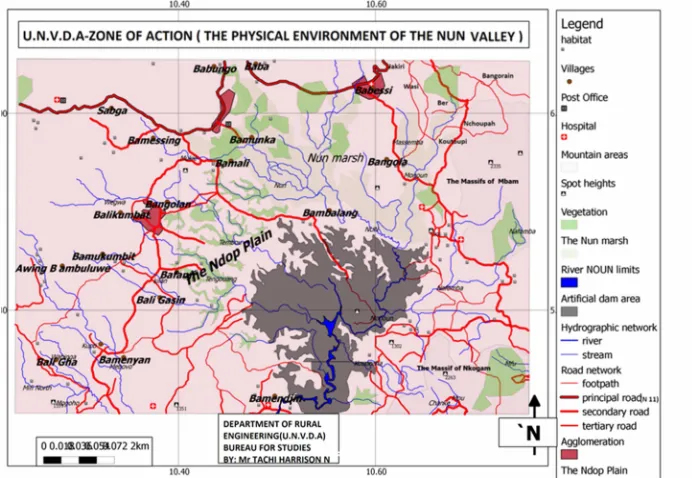
The Ndop Plain which is part of the Upper Nun Valley is an open highland (1020-1200m) inter-montane plain of the North West Region. This plain opens out to the south east through which the River Nun flows. It is located between Latitude 5°40ʹ and 6°10ʹ North of the Equator and between Longitude 10°15ʹ and 10°50ʹ East of the Greenwich Meridian. The plain is ensconced within the volcanic landscape of the North West Region of Cameroon (Figure 1). It is a monotonously flat to undulating landscape whose topography is broken either by ancient granitic residual hills or volcanic necks.
Source: Upper Nun Valley Development Authority, (UNVDA) Ndop, 2016.
This plain is studded by numerous marshes or swamps into which a host of tributaries unite to form the River Nun proper downstream. The varied relief of the plain has an orographic influence on the precipitation. Ndop Plain has an annual rainfall averaging 1500-2000mm. Rainfall is the sub-equatorial monsoon type with an annual average of between 1200mm and 2000mm. The wet season lasts for approximately 8 months, that is, from March to mid-November. The mean annual temperature is 21.3°C. The abundant water resources favour the cultivation of rice which is a water-loving crop while the short dry season favours the cultivation of market gardening crops in the rice fields, following the recession of the water table.
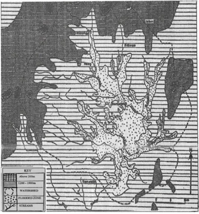
The topographic configuration alongside the high amount of precipitation received over the adjacent uplands contributes significantly in generating seasonal floods on this plain especially during the peak rainy months of July, August and September [9]. This is particularly a serious problem towards the Bamendjin area where the swamps and the dam
form an abundantly vast water empire which inundates the flood plains (Figure 2). The Ndop Plain is studded by numerous wetlands and pockets of salt springs into which a host of tributaries unite to form the River Nun downstream [10]. The flood waters, especially during the months of July, August and September, coincide with the growing period for rice. This causes serious threats to farmers who suffer from crop destruction and consequently some low yields.
Rice cultivation is a new innovation in the Ndop Plain that has come to stay. As a result, farmers of this plain have adopted indigenous farming strategies to guard against the adverse effects of present and future floods events and to enhance agricultural productivity in this part of Cameroon. This paper therefore attempts a prediction of the future trends in flood occurrences in the region and also examines the indigenous methods put in place by the farmers to address the problem of floods in order to enhance community food security in the Ndop Plain.
Region Showing the Inundated Area Source: (After Hawkins and Brunt 1965).
2. Methods of Study
This study adopted both the qualitative and quantitative research approaches to collect information. The Ndop Plain consists of a total of thirteen villages, namely, Bamessing, Bamunka, Bamali, Balikumbat, Bafanji, Bambalang, Bamukumbit, Baligansin, Baligashu, Bangolan, Babungo, Babessi and Baba 1. A cross section of the population was sampled using the random sampling technique to obtain their views on flood water levels and their impact on rice crops as well as the strategies put in place to fight against excessive flood events and their impact on agricultural production in the region. Climatic data such as rainfall and temperature values were obtained from the Agricultural Post in Babungo and the UNVDA Head Office in Ndop (Table 1). The study made use of the simple forecasting method based on temperature and rainfall data from Bamendjin to predict climate change evolution in the region. These hydrological data were used to determine the amount and intensity of rainfall for the region and how the amount of water can enhance flooding. Direct field measurements and surveys were equally conducted to assess the various indigenous adaptation strategies used by farmers to fight against frequent
flood events. Measurements of the length, width and heights of drainage were done in order to determine whether or not the drains could sustain the volume of water during periods of floods. Data were equally obtained from the farmers through the distribution of questionnaires in the 13 villages with particular interest on those villages practising rice farming on a large scale. These include Bamunka, Babungo, Babessi and Baba 1. A total of 150 questionnaires were designed. Fifteen questionnaires were administered in the four villages and at least 10 in the rest of the villages. The questionnaires were distributed randomly with no cultural or religious bias. These questionnaires provided data on the impact of too much water on rice farms and the indigenous strategies advanced to mitigate the hazards.
The UNVDA which is a government parastatal that oversees rice production activities in Ndop provided enormous data base for the study. Semi-structured interviews with some officials of the UNVDA provided data on the different species of rice produced in the Ndop Plain and the production trends over the years. The base line maps for the study were gotten from UNVDA
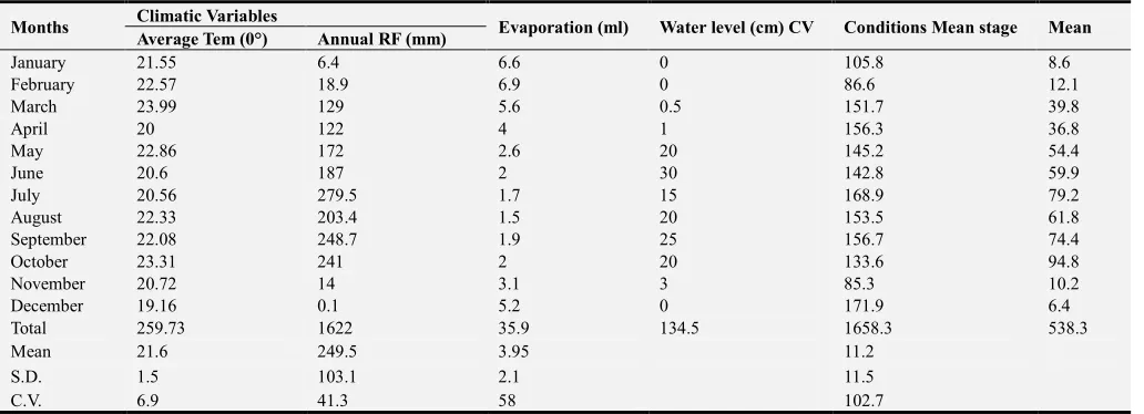
Table 1. Mean monthly hydro-climatic data for the Ndop Plain between 1990 to 2009.
Months Climatic Variables Evaporation (ml) Water level (cm) CV Conditions Mean stage Mean
Average Tem (0°) Annual RF (mm)
January 21.55 6.4 6.6 0 105.8 8.6
February 22.57 18.9 6.9 0 86.6 12.1
March 23.99 129 5.6 0.5 151.7 39.8
April 20 122 4 1 156.3 36.8
May 22.86 172 2.6 20 145.2 54.4
June 20.6 187 2 30 142.8 59.9
July 20.56 279.5 1.7 15 168.9 79.2
August 22.33 203.4 1.5 20 153.5 61.8
September 22.08 248.7 1.9 25 156.7 74.4
October 23.31 241 2 20 133.6 94.8
November 20.72 14 3.1 3 85.3 10.2
December 19.16 0.1 5.2 0 171.9 6.4
Total 259.73 1622 35.9 134.5 1658.3 538.3
Mean 21.6 249.5 3.95 11.2
S.D. 1.5 103.1 2.1 11.5
C.V. 6.9 41.3 58 102.7
Source: Babungo Agricultural Post, Ngoketunjia, 2009.
They also provided information on the impact of too much water on rice production and the strategies they are implementing to guard against the adverse effects of this climatic hazard. The MINEPIA, Ndop, provided data for the different crops in the region. Apart from these sources, most villages of the Ndop Plain are blessed with Agricultural Extension Workers who work in close collaboration with the farmers. These officials were interviewed in order to ascertain some of the field observations. The study has been illustrated by the use of maps, tables, graphs and plates. The tables illustrate the trends in climatic changes and flood incidences. The plates show the impact and indigenous strategies which have been put in place.
3. Results and Discussion
This study assesses the climatic trends for the Ndop Plain over a period of 25years and therefore predicts flood incidences in the region and their impact on agricultural production. It also investigates into the indigenous methods put in place to combat floods in the region..
Evidence and Trends of Climate Change in the Upper Nun Valley
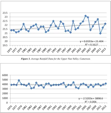
2013. Predictions were made from it in order to ascertain the climatic trends for the region over the number of years. Figure 3 reveals that temperatures for the region have been increasing in a fluctuating manner. An exponential increase was recorded between 2005 and 2007 with highest
temperatures recorded in 2005. Also, a gradual reduction in temperature was recorded in 2011 which shows evidence of temperature variability. This rapid increase in temperature has been the major reason for the seasonal changes in agricultural production in the Ndop Plain.
Figure 3. Average Rainfall Data for the Upper Nun Valley, Cameroon.
Figure 4. Rainfall Data for Bamendjin from 1975 to 2013, Cameroon.
From Figure 4, it is evident that rainfall is decreasing in a fluctuating manner. Field evidence therefore revealed that the occurrence of floods in this region is as a result of increased rainfall intensity within a very short time in an area that has already been tampered with by anthropogenic activities. The lack of vegetation leads to increased surface runoffs and consequently flood incidences in the basin. The occurrence of floods can also be justified by the fact that Ndop Plain is a basin surrounded by hills. Water collects from these surrounding hills rapidly into the basin which is also devegetated as a result of anthropogenic activities leading to floods.
It is therefore clear from this future prediction that there have been changes in the rainfall and temperature conditions of the Ndop Plain over the years leading to severe floods especially in the rice fields. This increased flood incidences over the years have rendered farmers vulnerable. Numerous hectares of rice fields have been lost to water as a result of increased floods in the region. This loss has been responsible for a reduction in the production of rice and other market
gardening crops in the region that depend on water recession for their growth. According to [20], rice is consumed by about three billion people and it is a staple food for a large number of people on earth. The number of consumers is expected to increase in future because of the increasing population, rapid urbanization and change in diets. This is the scenario in the Upper Nun Valley where the population has been increasing without a commensurate expansion of food production in a region whose economy is purely agrarian. This explains the reasons why indigenous adaptation measures are put in place to guard against crop failure in the plain.
and failure to widen the drains in order to direct the flow of water. This has been one of the major reasons for the excessive flooding in the rice fields in the Upper Nun Valley. Although paddy rice requires plenty of water for its growth, too much water equally affects its productivity. Field evidence has proven that there has been a reduction in agricultural output in the Ndop Plain over the years as a result of increased floods. (Table 2).
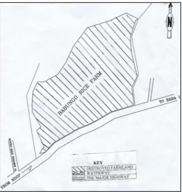
Table 2 presents the production of rice in the Upper Nun Valley since the creation of the UNVDA. It is clearly evident that besides the economic crisis of the 1980s, a fall in production over the past years can be attributed to increased floods that destroy hectares of farmlands together with the rice crop as it was the case of the 84 ha of the UNVDA farmland in Babungo that was destroyed by floods in 2015. The table equally reveals that a tonnage of rice per hectare is at least 3tons/ha. This therefore means that the 84 ha loss is worth the production of 252 tons of rice. 10,000kg of rice is equal to 1ton. So 252 tons is equal to 2.520.000kg. Since 1kg of rice costs 120 FCFA, it therefore means that the 2.520.000kg cost a phenomenal loss of 302.400.000FCFA per year, as illustrated in the calculations
below:
84x3=252tons 1ton=10,000kg 252tons=2520000kg 1 kg = 120 FCFA
Therefore 2520000x120=302.400.000FCFA
The flooding was so severe that it led to the destruction of the stretch of road linking Babungo and a neighbouring village, Baba 1. This did not only reduce agricultural production but also slowed down communication along the major highway linking Bamenda and Kumbo. This is presented in Figure 5. Besides rice failure, the farmers also suffer from the loss of other agricultural products like maize, beans, tomatoes, okra, cocoyams, pepper, and water melon amongst others cultivated in these rice fields when the water recedes. The increased flood has resulted in the leaching of soluble nutrients from the soil, blocking of soil microbial activities, and reduced mineralization and nutrient release from the soil complexes. This is so because too much water washes away the top nutrients in the soil which are very important for plant growth.
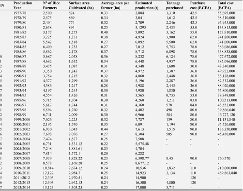
Table 2. Production trends for rice from 1977 to 2014.
S/N Production
Year
N° of Rice Farmers
Surface area Cultivated (ha)
Average area per farmer (ha)
Estimated production (t)
Tonnage purchased
Purchase cost (F.CFA)
Total cost (F.CFA)
1 1977/78 2,500 824 0.33 2,884 1,310 42.5 55,695,000
2 1978/79 2,575 869 0.34 3,041 1,612 42.5 68,510,000
3 1979/80 2,404 774 0.32 2,709 2,246 42.5 95,955,000
4 1980/81 2,638 894 0.25 3,1295 2,433 55.0 133,815,000
5 1981/82 3,177 1,273 0.40 5,092 3,162 55.0 173,910,000
6 1982/83 3,225 1,231 0.38 4,924 3,900 62.0 241,800,000
7 1983/84 5,542 1,518 0.27 6,092 5,500 62.0 341,000,000
8 1984/85 6,400 1,753 0.27 7,012 5,753 78.0 386,686,000
9 1985/86 5,862 2,178 0.37 8,712 6,898 78.0 538,838,000
10 1986/87 5,687 2,058 0.36 8,232 6,124 78.0 477,672,000
11 1987/88 4,682 1,612 0.34 6,448 4,937 78.0 385,096,000
12 1988/89 3,475 1,087 0.31 4,348 1,608 30.0 48,240,000
13 1989/90 3,350 1,243 0.37 4,972 1,387 36.0 49,932,000
14 1990/91 3,754 1,215 0.32 4,860 2,448 36.0 88,128,000
15 1991/92 4,377 1,299 0.30 5,196 2,287 36.0 82,332,000
16 1992/93 4,386 1,247 0.28 4,988 2,445 36.0 88,020,000
17 1993/94 4,197 1,245 0.30 4,980 1,830 36.0 65,800,000
18 1994/95 4,554 1,426 0.31 3,565 0,733 53.0 38,849,000
19 1995/96 5,715 1,704 0.30 4,260 1,211 83.0 100,513,000
20 1996/97 5,617 1,744 0.31 4,360 578 84.0 48,552,000
21 1997/98 5,594 1,760 0.32 4,402 498 80.0 39,866,640
22 1998/99 6,741 2,009 0.30 6,966 584 80.0 46,727,120
23 1999/2000 7,026 2,225 0.32 7,787 139 80.0 11,131,840
24 2000/2001 2,195 1,740 0.35 6,091 1,194 80.0 95,520,000
25 2001/2002 6,930 3,045 0.44 7,613 1,515 90.0 136,350,000
26 2002/2003 7,698 2.076 0.27 8,304 505 90.0 45,450,000
27 2003/2004 7,474 1,877 0.25 7,508 - - -
28 2004/2005 6,731 1,531.12 0.22 5,575.48 - - -
29 2005/2006 7,248 1,881.61 0.25 4,704 - - -
30 2006/2007 7,814 1,572.1 0.20 6,282 - - -
31 2007/2008 7,939 1,828.22 0.23 6,398.77 8.45 90.0 760,770
32 2008/2009 8,578 2,169.28 0.25 8,677.12 - - -
33 2009/2010 10,814 2,634.12 0.24 10,536 1,832 110 210,000,000
34 2010/2011 12,122 2,984.7 0.25 14,923 3,134 110 489,863,840
35 2011/2012 12,303 2,970.51 0.24 14,900 - 120 -
36 2012/2013 12,303 2,942.13 0.24 16,500 4,800 120 -
37 2013/2014 13,123 3,303.25 0.25 17,000 3,711 - -
Source: Taichi &Tarsiwan, UNVDA Ndop, (2016) Area-84ha, Scale 1/50.
Figure 5. Map of the Layout and Areal Extent of the UNVDA Farmland Destroyed by Heavy Floods in 2016 in Babungo, Ngoketunjia.
Table 3 and Figure 6 present market gardening crops cultivated in the Upper Nun Valley and changes in some of the prices for these crops. From Table 5, it is evident that the prices of these agricultural products have been increasing over the years. This can be attributed to an increased demand over a limited supply. The fall in supply is a result of increased floods that tend to reduce the production yields over the years. The Ndop Plain is an agrarian economy whose population depends on the land for sustenance. A fall in agricultural production implies a reduction in the standards of living due to the fall in disposable income. This scenario has not only affected the agricultural sector but other development sectors of the region as livelihoods are considerably based on agriculture. Because agriculture constitutes the backbone of the economy of this region, the farmers have embarked on indigenous strategies to fight against this adverse climatic hazard which this paper has attempted to investigate and to propose better adaptive measures for posterity. Figure 6 presents the fluctuations in climatic elements and the variation in the production and prices of rice in the Ndop Plain. The increase in the prices of the main crops cultivated is as a result of flood incidences and the fall in food crop production against increased demand. There is therefore the need for indigenous adaptation strategies to guard against this problem.
Source: Fieldwork, 2016.
Figure 6. Variation in crop production and changing prices of some basic commodities in the Ndop Plain from 1980 to present.
Indigenous Adaptation to Flood Incidences in the Upper Nun Valley.
Adaptive strategies to climate variability must take into consideration the indigenous approaches that the communities are familiar with and which they can readily apply themselves. In an attempt to portray the significance of traditional or indigenous knowledge in the management of climate variability, [2] identified three different ways of understanding the concept of Indigenous Knowledge. The first approach considers it as an inheritance from the past. The second approach describes it as a representation of an alternative way of thinking, typical of African cultures. The third definition considers Indigenous Knowledge as a means to express what people know and create new knowledge from the intersection of their capacities and development challenges. Indigenous knowledge is conserved orally, transmitted from one generation to another and communicated through proverbs, deities’ beliefs, songs, and spiritual practices, which encompass rules with dos and
don’ts. The study examined the nature of indigenous
knowledge systems and adaptation mechanisms for the management of floods in the Ndop Plain. Over time, the local communities on the Ndop Plain have developed local strategies to cope with the effects of climate change and flooding and how to enhance agricultural production.
Table 3. Market Gardening Crop Production Data.
Year
Tomatoes Huckleberry Cabbage Okra Pepper
Average production Area (HA)
Average production (Tons)
Average production Area (HA)
Average production (Tons)
Average production Area (HA)
Average production (Tons)
Average production Area (HA)
Average production (Tons)
Average production Area (HA)
Average production (Tons)
2006 4985.8 16453.1 2576.1 1288.1 3444.5 6871.2 4399.8 4296.1 4508.4 2209.3 2007 5105.8 16849.1 2663.1 1331.6 3540.9 7081.8 4491.7 4401.8 4632.1 4491.7 2008 5331.6 17594.1 2728.2 1364.1 3747.4 7494.8 4601.1 4514.6 4828.3 2373 2009 5367.9 31013.9 2748.2 2738.2 3749.8 9135.8 4621.2 6825.1 4839.5 4792.8 2010 5395.3 31416.9 2762.3 2807.2 3755 9146 4626.7 6940 4849.5 4802.7
2011 1365 27300 3760 5640 4854 7281 4912 7368 3148 6296
2012 1366 27320 3763 5645 4859 7289 4916 7374 3155 6310
2013 19163 1643
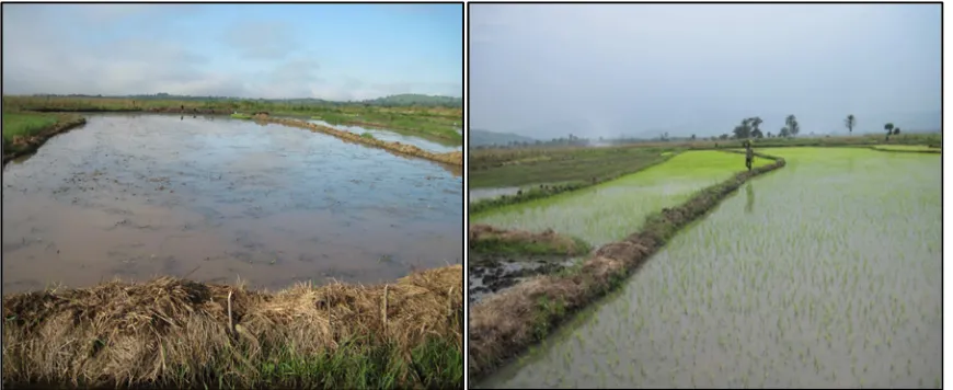
One of the ways through which the indigenous people have been trying to adapt to floods is through the use of sand bags as causeways to ease communication and to divert the water and channel it into the stream. This has been successful to a limited extent depending on the volume and energy of the water. The creation of small canals at the upper course in
the past often diverted the water since the volume was small but with time, the increase in the volume of the water has made it difficult for the drains to effectively contain the volume of the flood water. This was the case of the Babungo rice farm that was completely destroyed in 2015 to the extent that cultivation could not take place that year.
Figure 7. Demarcation of rice fields with grass and bamboos to prevent water from entering the farms. This is a crude and very vulnerable method of flood mitigation.
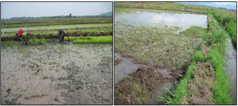
Though the UNVDA came in to help by constructing a central dig which serves as embankments and canals to block water from entering into the farms from the upper part, it only helped to reduce the volume of water. The problem was not completely solved as it led to the destruction of the road linking Babungo and Baba I as seen in Figure 4. The wetlands where rice production is carried out have raphia palms with bamboos as well as grasses that the communities adapted as a source of building materials and building style to withstand the regular devastating flood disasters in the rice fields. It was noted that the communities take a cue from natural features in the areas to construct their river banks. This is done through the compilation of grass on the banks of the rice farms in order to increase the height and at the same time not tempering with the depth of the banks. These grasses are firmly supported with bamboos pinned into the ground. The grass helps to prevent water from overflowing the banks and also differentiates the boundaries of each plot. On these banks, farmers plant elephant stock that grows permanently on them. The roots bind soil particles together thereby preventing erosion. It also prevents water from entering the farms. Water only penetrates when the carrying capacity is exceeded or when the banks are week. The bamboos are used to constantly regulate the flow of water in the farms. These bamboos have pathways through which water can enter the farms. During periods with excessive amounts of water, the path way is blocked and during water deficiency, it is opened to release water into the farms. The bamboos equally enable the farmers to move on the banks into the rice fields. This is presented in Figure 8. It is evident that these banks are too small and consequently cannot withstand heavy floods during the rainy season. The height of the canals that block water from entering the farms is not
above 40m.
In order to work towards floods mitigation in the Ndop Plain, the indigenous populations have engaged in community development through the help of Common Initiative Groups (CIG). These groups contribute money and go to the UNVDA for assistance. The UNVDA then supplies them with heavy machinery like the excavators to dig canals to the desired depths. This helps for easy circulation of water within the rice fields. Once in a while, these CIGs go out to clean and widen the drains through community labour in order to enhance water movement. Community development in this region is very active and dynamic. Through community labour, the main water channel is dug. Any defaulter pays the sum of 1,500FCFA per day. The banks are dug using hoes, cutlasses and pig axes. Once they are dug, mud is put on them to the required height. The drains are 2m wide while the height from the surface to the main water dip is 1.15m. When two channels meet, the gutters are widened more than normal because the volume of the water increases. The banks of the channels are also increased to 1m x 50cm so as to prevent water from entering the farms. But most often, the sizes of the drains are still not enough to contain large amounts of water especially when two main drainage channels merge leading to severe floods.
the distance is 2m by 0.9m. The small sizes of these drains can be attributed to the fact that they were built some years back when flood waters were minimal. But today, as a result of an increasing watershed degradation, the floods have exceeded the carrying capacity of the drains leading to severe floods. It was also realized that the heights of canals that
block water from entering the farms are low generally about 40cm or thereabout. Figure 8 shows farmers on community labour and the size of the drains they construct. Table 4 presents some mechanisms that have been put in place to guard against floods in the Ndop plain of the Upper Nun Valley of Cameroon.
Table 4. Coping Mechanism and Indigenous Technologies in the Ndop Plain.
Communities Coping Mechanism Indigenous Technology/Local Adaptation Strategies
Bamunka Financial assistance from the community cooperative Construction of wooden bridges, mud and concrete embankments
Babungo Mutual support in the community Creation of pathways for water, used of bamboos and grasses to build embankments to prevent direct water entering into rice farms Baba1 Mutual support in the community Culverts and gutters, Mud and concrete embankment Babessi Mutual support in the community Building on raised platform or pile foundation Bambalang Mutual support in the community Culverts and gutters, Mud and concrete embankment
Bafanji Mutual support in the Community Construction of wooden bridges, mud and concrete embankments
Source: Authors’ Fieldwork, 2016.
Figure 8. Farmers on community labour in Bamunka, Ndop. Note the very small sizes of the drains in the rice fields.
The construction of channels or canals in rice farms was reported to be more helpful in controlling water logging in farms and to drain water from the farms to overcome floods. However, since floods cause damages on local infrastructure, local communities have been constructing temporal wooden bridges to ensure communication within and across the farms.
A lot has been done by the indigenous people of the Ndop Plain to fight against the impact of climate change and to enhance agricultural productivity. But field evidence proves that much is yet to be done in the phase of changing technology for better adaption. That is why in this study, some sustainable adaptation strategies have been recommended.
Proposed Solutions Against Climate Change Impacts and Agricultural Enhancements in Ndop Plain
Rice cultivation is an important economic activity in the Ndop Plain and an activity that has come to stay. As a result, measures have to be put in place in order to sustain and improve upon the quality of production. Field studies show that the instruments used by the local communities to open the drains are local and very rudimentary in nature, making it difficult to dig the drains wide enough in order to contain the flood waters. The UNVDA has come in to reconstruct the
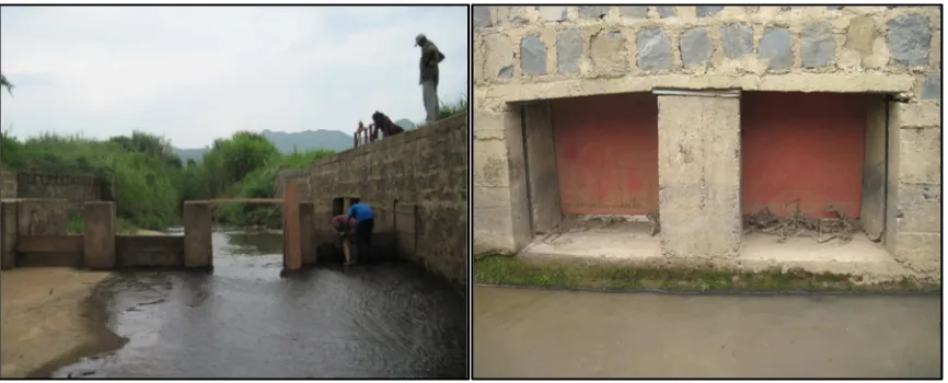
canals and the banks to about 30cm. This manages water by creating inlets into each individual’s farms using pavements made of stones. Planks are used to block water from entering individual farms until when the need arises. The canals prevent dredging and less water is lost through infiltration. Through the CIGs, the farmers can contact the UNVDA for necessary assistance. This would not only ease the work but would create drains that can effectively contain flood waters (Figure 9).
Figure 9. Drains constructed by UNVDA to guard against floods in the Ndop Plain.
Above all, there should be the blending of Indigenous Knowledge with Scientific Knowledge for successful climate change adaptations. Ongoing climate change debates focus on how indigenous knowledge (IK) can be effectively integrated with scientific knowledge (SK) and existing government policies and programmes in responding to climate-related risks. As such, the use of IK alongside SK is increasingly emphasized. Thus, this article suggests that the attainment of successful climate change adaptation indeed requires an integration of IK and SK so as to benefit from the strengths of the two in a complementary manner. In this regard, existing government policies and programmes on climate change adaptation require an integration of IK to complement the SK informed policies. It is clear that IK which has been used by local communities for decades can provide relevant information that will improve the government based adaptation strategies on climate change. In the new arena of sustainable development, there is a sense in the ongoing discussion that the execution of different development projects among the rural poor communities should consider the integration of IK. As noted in [15], IK has been perceived by many as an alternative way of promoting development in poor rural communities in different parts of the world.
It is also worth noting that as the local communities find it complex to adapt with climate change using SK like high input agriculture and biotechnology, they have to continue relying on their indigenous skills. Though, most of the IK could only be applicable in the short term, the integration of IK and SK is inescapable [18], In this regard, local experts with Indigenous Knowledge should meet with scientific experts like the UNVDA extension staff, and policy makers to develop harmonized adaptation strategies which stand as bridges between their systems of interpretations. This integration should target any existing gaps so as to add value to local adaptation practices applied on the ground. Conversely, the local communities proposed that the indigenous knowledge should be used more widely alongside scientific knowledge in order to increase the reliability and acceptability of overall adaptation strategies
at local level. Local communities need to be empowered to recognize the relevance of their knowledge and how it could contribute to reducing floods and adapting to climate change impacts in Ndop Plain of the Upper Nun Valley of Cameroon.
4. Conclusion
Extreme climatic events such as changes in mean climate as characterised by droughts and floods have direct impact on crops, and consequently, the local communities’ livelihoods. According to [8] poor communities mainly residing in Sub-Saharan Africa (SSA) are anticipated to be most vulnerable due to their low adaptive capacity and high reliance on climate sensitive resources such as water and the ecological systems. The livelihoods of these communities are directly connected to nature. Hence, a continued reliance on natural resources which are greatly affected by climate change impacts presents lots of pressure on them [16]. It is as a result of this that the local communities of Ndop Plain are adapting strategies to guard against flood incidences in the Ndop Plain. Through the use of their Indigenous Knowledge, local communities are able to construct and respond to the impacts of climate change in creative ways.
References
[1] Babungo Agricultural Post, Ngoketunjia, North West Region, Cameroon (2009).
[2] Easton, P. B. (2004). Education and Indigenous Knowledge. In R. Woytek, P. Shrof Mehta, & P. C. Mohan (Eds.), Indigenous Knowledge. Local Pathways to GlobalDevelopment. Marking Five Years of the World Bank Indigenous Knowledge forDevelopment Program, (pp. 9-12). Knowledge and Learning Group Africa Region: The World Bank. Retrieved from: http: //worldbank.org/afr/ik/default.htm.
[4] FAO, (2010): Climate-Smart Agriculture: Policies, Practices and Financing for Food Security, Adaptation and Mitigation. Rome: FAO, 42 pp.
[5] Green, D., & Raygorodetsky, G. (2010). Indigenous knowledge of a Changing Climate. Climatic Change, 100, 239-242.
[6] Grenier, L. (1998). Working with Indigenous Knowledge: A Guide for Researchers Manual. (p. 100). IDRC, Canada.
[7] Hawkins. P and Brunt. M. (1965): The soils and ecology of west Cameroon (with special refernce to the Bamenda Area), FAO, N°2083, Rome
[8] IPCC (2007): Contribution of working Group II to the Fourth Assessment Report of the IPCC – Summary for Policy Makers. Retrieved March 8, 2010 from http://www.ipcc.ch:
[9] Kometa S. S. (2012): Flood Characteristics and Implication for Agriculture within the Ndop Plain, North West Region of Cameroon. in Journal of Applied Social Sciences, A Multidisciplinary Journal of Social Sciences, Volume 3, Number 1, pp 107.
[10] Lambi C. M. (2001): The Bamendjin Dam of the Upper Nun Valley of Cameroon; No Human Paradise. In Culture and Environment, A Reader in Environmental Education, Design House, Limbe, Cameroon. pp 223 – 231.
[11] McGregor, D. (2004). Traditional Ecological knowledge and Sustainable Development Towards Coexistence, IDRC. Retrieved from: http://www.idec:en:er-64525-201-Do_Topic.html.
[12] Melchias, G. (2001). Biodiversity and Conservation. Enfield: Science.
[13] Newsham, A. J., &Thomas, D. S. G. ( 2011). Knowing, farming and climate change adaptation in North-Central Namibia. Global Environmental Change, 21, 761-770.
[14] MINADER (Ministry of Agriculture and Rural Development), (2009):Stratégie Nationale de Développement de la Riziculture au Cameroun: Mouture III. Yaoundé- Cameroun: MINADER, 21 pp.
[15] Nyong, A., Adesina, F., & Elasha, B. O. (2007). The value of Indigenous knowledge in climate change mitigation and adaptation strategies in the African Sahel. Mitigation and Adaptation Strategies. Global Change, 12, 787-797.
[16] Salick and Byg, (2007). Indigenous Peoples and Climate Change. Report of Symposium 2-13 April 2007. Tyndal Centre for Climate Change Research, Oxford, UK: A Tyndal Centre Publication available at http: //www.ecdgroup.com.docs/pdf.
[17] Sharma, P. K (1989): Effect of Period Moisture Stress on Water-use Efficiency in Wetland Rice, Oryza,26:252-257.
[18] Shemsanga, C., Omambia, N. A. and Gu, Y. (2010): The Costs of Climate Change in Tanzania. Impacts and Adaptations. Journal of American Science, Vol 6 (3), pp. 182-196.
[19] Tata, E. S. (2016): Climate Variability and Wetland Exploitation in the Bui-Ngoketunjia Divisions of Cameroon: Development Implications, Unpublished PH.D Thesis, Department of Geography, University of Buea, pp 346.
[20] Wassmann, R (2010). Advanced technologies of rice production for coping with climate change: ‘no regret’ options for adaptation and mitigation and their practical uptake. Proceedings of the workshop Advanced Technologies for Adaptation for coping with Climate Change: ‘No Regret’ Options for Adaptation and Mitigation and their Potential Uptake held on 23-25 June 2010 in Los Banos (Philippines), Los Baños Philippines: International Rice Research Institute.
[21] Ziervogal, G. and Opere, A. (2010): Integrating Meteorological and IK-based Seasonal Climate Change Forecasts in Agricultural Sector. International Development Research Centre, Ottawa, Canada. Climate Change Adaptation in African learning Paper Series.