Licensed under Creative Common Page 352
http://ijecm.co.uk/
ISSN 2348 0386
ALBANIA – AN IMPORTANT GOODS TRANSPORT HUB
TO SOUTH AND NORTH-EAST EUROPE
Drakuli Lumi
PhD candidate, Department of Mechanics and Transport, "Aleksander Moisiu" University, Durrës, Albania
Osman Metalla
Department of Mechanics and Transport, "Aleksander Moisiu" University, Durrës, Albania o.metalla@gmail.com
Abstract
The Adriatic Sea area represents an important European HUB for the transport of good flows
coming from the entire globe. Approximately 126 million ton per year (nearly 21%) of this flow
passes throughout this zone into the continent. The port of Durrës is a crucial part of the eastern
region ports network. This paper analyses the traffic flows that goes from EU toward Balkans.
Albania is situated in the center of this traffic flow and can play an important role as a transport
hub. This paper evaluates the possibilities that Albania has in order to become a central
transport hub, throughout combined and integrated infrastructure investments. The substantial
investments made in the ports infrastructure and Albanian road network of this area have given
way to the manufacturing process of part of this flow that passes through this region of the
Adriatic Sea. The connection of the Albanian Road Network to the Pan-European Network of
Transport TEN-T is made all over six border crossings. Due to its key geographical position,
Albania can play an important role in the processing and delivery of these goods, not only in the
countries of Southeastern Balkan but even to greater distances, such as South and North-East
Europe.
Licensed under Creative Common Page 353
INTRODUCTION
Albania is located in the middle the intersection of multimodal good flows transport roads passing through the Adriatic Sea. Figure 1 shows statistical data for the circulation of these flows to the EU, according to the year 2013.
Figure 1: Good flows from other regions to the European Union countries, in 2013.
Source: Eurostat – Maritime transport - Goods
Part of this flow ought to be realized passing through Albania. The National Transport Network, in this case formed from portal and road infrastructure, would guarantee the connection of Paneuropean Corridors of transport, Figure 2. The connection of the Albanian road network to the Paneuropian corridors of transport is made through the border crossings of:
Morina (Kukës) by means of which the Albanian road network is related to Corridor X
(Nish).
Bllata (Peshkopi) With the completion of Arbëri’s road, Tirana will be connected to
Macedonia by the itinerary Tiranë-Blatë-Gostivar (Macedonia) and Corridor VIII will after that be connected to Corridor X (Shkup).
Qafë Thana (Pogradec) by virtue of which Corridor VIII is related to Corridor X (Shkup),
to Corridor IV (Sofie) and beyond that to the Corridors VII and IX.
Kapshtica (Devoll) on account of this bifurcation in the border crossing, Corridor VIII is
linked to Via Egnatia (Igumenicë-Selanik-Stamboll):
Licensed under Creative Common Page 354
- In the itinerary Kapshticë – Kastoria (Greece)-Siatista (Greece).
Kakavija (Gjirokastër) thanks to which Corridor VIII is connected withVia Egnatia in the
itinerary Vlorë/Durrës - Gjirokastër -Kakavijë-Ioannina.
Qafë Bota (Sarandë) by way of which Corridor VIII is related to Via Egnatia in the itinerary Vlora’s port-Sarandë-Qaf Botë-Igumenicë.
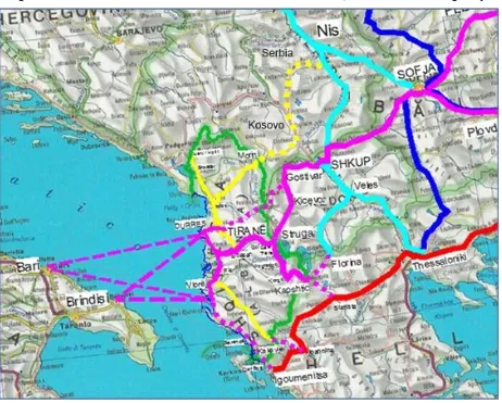
Figure 2: The conection of the Albanian network to Corridor VIII, X and EGNATIA Highway.
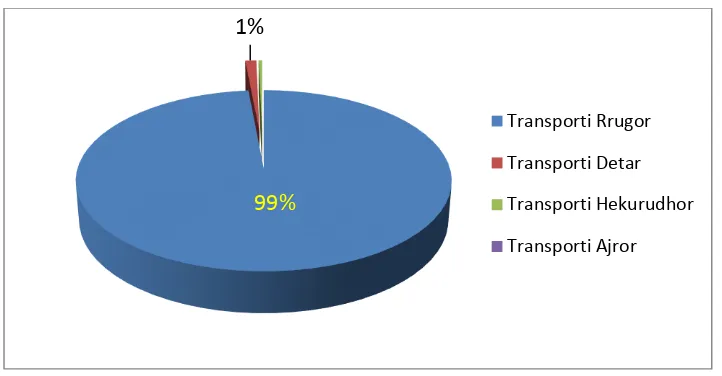
Licensed under Creative Common Page 355 Figure 3: The realization of investments according to the sectors of Transport for the year 2014
From this point of view, a great option is the construction of the “Industrial Village of Tradings” (FITM), which is part of the prospective approved plans for the evolution of the
metropolitan zone Tiranë-Durrës. Issued with a contemporary logistic, it would be a new junction of the supply chain and would be presented as the solution of transport that guarantees the requirements of infrastructure in order to realize a harmonic interaction between the means of transport. The construction of this Industrial Village would deflect a series of negative fenomens such as:
Augmentation of the number of obstructions in Road Transport
Enlargement of environmental pollution
Enhancement of utter transporting costs
Augmentation of total industrial production costs
Amplification of the process of deindustrialization
Diminution of the competition in the industrial sector.
The construction of the Industrial Village is closely related to the flows predicted to pass through the port of Durrës and to the possibility of their elaboration.
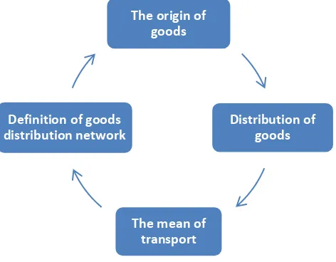
Analysis of the goods flow freight
This analysis has been realized on account of the “4 steps” sample, which is well known and
widely used to analyze the predicted freight flows (figure 4). They are:
The origin of goods;
Distribution of goods;
The mean of transport;
Definition of goods distribution network.
99%
1%
Transporti Rrugor
Transporti Detar
Transporti Hekurudhor
Licensed under Creative Common Page 356 Figure 4: The “4 steps” sample for the establishment of traffic flows
In the first step, the outcome and attractions are evaluated in categories for each zone. This is achieved using the actual volumes data and even the socio-economical data for the next years. The generated goods are divided into internal, delivered within the zone and exporting goods, addressed hence the zone. Furthermore, arriving goods are divided into internal, from within the zone and imported ones, coming from other zones. In this study, the generated and arriving goods are based in the following socio-economic factors:
Gross Domestic Product (GDP), for each zone;
The population of each zone;
Industrial goods of each zone;
The employment of each zone.
The second and third steps of this study will be discussed together, based on the samples of
goods transported between the zones, according to the mean of transport. In the module of allocation of trips, the terminal of each trip, evaluated in the first step (generated or arrival), is already defined.
As a consequence, the trips are divided according to different means of transport, based on the evaluation of total cost of assigned goods. The data for costs, distance and trading costs between the zones are used for the establishment of the total trading costs according to the mean of transport.
After the division in short and long term trips, they are sectioned off according to the total trading costs, needless to say by the means of transport. It is important to emphasize that only long term trips are divided in different means of transport.
The origin of goods
Distribution of goods
The mean of transport Definition of goods
Licensed under Creative Common Page 357 Short term trips are realized only via Road Transport. Data for cost, distance and the duration of trips in the zone are used to estimate the total cost, according to the group of goods and to the mean of transport.
The fourth and last step of this methodology is the determination of allocation networks, through which is reported the quantity (in ton) of the group of goods, transported in various ways in the existing transport network.
The method used in this study to determinate these networks, is based in Multi class equilibrium Assignment algorithms, which exist in the Platform Cube.
“CUBE” Model Results
“CUBE” Model has been elaborated focusing on two points: Basic years and forecasted years.
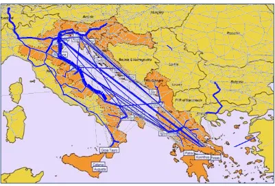
2010 and 2013 were chosen as basic years, so data for goods flow in the Adriatic Sea zone were collected from internal sources such as Eurostat, ETIS-Plus, INTERMODADRIA and port websites. As for the forecast, the model was applied in two plans, 2025 and 2030, considering the socio-economic evolution of the country. Based on this data, the simulation in the Adriatic Sea zone gives a panorama of the maritime line and goods flow, for both methods of transport service provided, with container and Ro-Ro (figure 5).
Licensed under Creative Common Page 358 As shown, for the part of our country's interest, the largest transportation flow of goods with wheel tools (RoRo) is expected to be in the following directions: Durrës Bari and Durrës -Trieste. Even in Durres-Ancona line is expected a significant goods flow.
As for the transportation by containers, it is expected that the largest flow will be withdrawn from Koper line and less of it from Gioia Tauro. In particular Durres-Koper line is thought to have a goods flow from 1,143,477.8 tons/year for 2025 and 1,158,999.3 tons/year for 2030.
It serves to the flow of goods passing from Albania to Central and Eastern Europe. Also the port of Koper is the largest HUB of Adriatic area, which distributes the flow of goods from big distances, such as the Far East, in the Adriatic Sea ports via supply service.
And in particular to the port of Durrës, Cube model results indicate that it will withdraw flows from Albania, Montenegro, Kosovo and Macedonia.
In figure 6, are given goods flow directions from/ to above areas, through the transport network of Durrës port.
A part of the flow, mainly destined to Montenegro, passes by the Montenegrin port of Bar. But the main part passes from Durrës and the same prediction is estimated to be even for the years 2025 and 2030. The future connection of the port with Road and Rail Network will provide the flow of goods turnover directly from their origin/destination, to the port of Durrës.
Figure 6: Traffic of good flows with direction from/ to Albania
Port of Durrës
Licensed under Creative Common Page 359
Simulations for short distances
Finally to understand the advantages submitted by the transport of goods through the port of Durrës and FITM, let's have a look at simulations for short distances to some destinations of Southeast European countries.
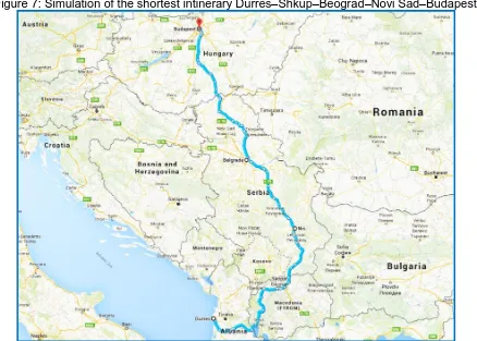
Itinerary: Durrës – Shkup – Beograd – Novi Sad – Budapest, (figure 7), an 1162 km
long itinerary traversable in almost 19 hours. Being both part of the Corridors VIII and X, they offer the chance of a fast and impressivly economic transport. As an alternative, we can list some other options:
Durrës – Podgoricë – Zagreb – Budapest, 1223 km long, almost 20 hours.
Durrës – Podgoricë – Sarajevë – Budapest, 957 km long, nearly 20 hours.
Ploce – Sarajevë – Budapest, 847 km long, approximately 14 hours.
Koper – Lubjanë – Maribor – Budapest, 568 km long, traversable in 9 hours.
As it can be seen, the passage through Montenegro can not be an option, due to the absence of Paneuropean Corridors. Other alternatives, such as the ports of Ploce (Kroatia) and Koper (Slovenia), despite being part of the Corridor V and constituting a short land distance, can not be considered beacuse they are not economically acceptable. For both of them we must include the time spent for transport by ship, respectively 9 hours (178 miles) and 21 hours (380 miles).
Licensed under Creative Common Page 360
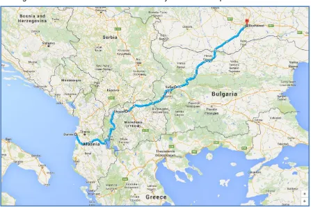
Itinerary: Durrës – Shkup – Sofie – Bukuresht, (figure 8), is an 923 km long itinerary,
which can be traversed during approximately a 15 hours trip. It is visibly shorter and the mos economic itinerary, being it composed by two parts of the Corridors VIII and IX. Other sub-alternatives are the following:
Durrës – Shkup – Nish – Krajova – Bukuresht, 978 km long. It can be
traversed for almost 16 hours.
Ploce – Beograd – Bukuresht, 985 km, approximately 16 hours.
Ploce – Zagreb - Beograd – Bukuresht, 1485 km long.
Selanik – Sofie – Bukuresht, 672 km long, traversable in nearly 11 hours.
For the reasons mentioned above, Romania can’t make any use of the transport from the
Croatian port of Ploce. Another alternative that can be taken under consideration is the Greek port of Thessaloniki, which is economically satisfactory.
However, in this case there are a series of other alternatives that need to be considered as well.
Licensed under Creative Common Page 361
DISCUSSION
According to the analyses we did in this paper it is clear that Albania has a very strategic position, being in the centre of the traffic flow. Being aware of this Albanian government has followed a clear strategy in improving the transport infrastructure in order to increase the traffic flow that passes through it territory. Apart of this clear strategy, there have been a significant discrepancy among investments performed in different transport infrastructure sectors. It is clear that road sector has been the most favourable one, with almost all funds being dedicated to this sector, leaving the other transport sectors practically without investments at all.
Rail sector which is in very poor conditions, has remained without investments, therefore in very poor conditions, thus no meeting the minimum technical standards required for international transport. This is one of the biggest transport handicaps that Albanian transport sector is suffering.
The simulations for short distances shows that Albania obviously has strong potentials in reaching the markets of Balkans, (apart of port of Thessaloniki which has a shorter distance) being the shortest land route, but again the lack of rail service and the missing links we have with Macedonia, make Albanian transport sector not very competitive.
CONCLUSIONS
Albania can turn into Balkans’ HUB for multimodal transport of goods to South and North-East
Europe. This would however imply the fulfilment of a legislative framework based on the recommendations of the EU and in the experience of its most industrialised countries. A determining priority would be the development of Railway Transport, in order to satisfy the parameters of the European Network of Railway Transport and be compatible to it. The creation of Interports and of the Industrial Village of Freight Transport should be linked to the integration of the System of Intelligent Transport to those of proximate countries.
REFERENCES
White paper 2011 Roadmap to a Single European Transport Area - Towards a competitive and resource efficient transport system, EC Brussels 2011;
White Paper 2001 European transport policy for 2010: time to decide European Commission, Brussels, 12.9.2001;
European Union guidelines for the development of the trans-European transport network EC July 2010 Extension of the major trans-European transport axes to the neighbouring countries and regions (TEN-T); Impact Assessment White Paper Transport 2011 EC Brussels 2011;
Transport Infrastructure Regional Study (TIRS) in the Balkans ECMT 2002 Louis Berger;
Licensed under Creative Common Page 362 INTERMODADRIA Project “Supporting intermodal transport solutions in the Adriatic area” May 2015, funded by the European Union;
Guidelines for transport in Europe and neighbouring regions EC 2007;
Continued recovery in volume of goods handled in EU ports. Eurostat Statistics in focus 7/2013;
Traffic flow: Scenario, Traffic Forecast and Analysis of Traffic on the TEN-T, Taking into Consideration the External Dimension of the Union. TENConnect - Tetraplan A/S Copenhagen, Denmark 2009;
Regional Balkans Infrastructure Study – Transport (REBIS) EC CARDS Programme 2004;