Soil Moisture Mapping Using Active Microwave for a Semi-Distributed Hydrologic Model: Case study in Turkey
Full text
Figure


Related documents
Volumetric soil moisture from both AWS observations and FLDAS Noah model were used as a dependent variable, while backscatter values of both VV and VH polarizations from Sentinel-1
The most common method for creating soil moisture maps is to use data that are manually collected at pre-determined locations in the field and extrapolate the expected measurements
Time variations of daily soil moisture (% vol/vol) retrievals from radiometer (open circle) and scatterometer (closed circle) at 29 ◦ incidence angle compared with the truth
Further experiments were carried out to semi-arid region USDA ARS experiment watershed. Remote sensing soil moisture measurement from AMSR-E NASA EOS Aqua satellite was used
Disaggregated soil moisture estimates along with the developed profiles were compared with the Noah land surface model (LSM), as well as in situ measurements from 10 Natural
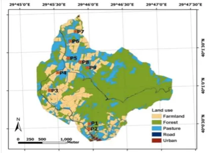
Validation of the proposed algorithm is based on com- parisons between ground-truth measurements made in test wheat fields (P4, P6, P7, P9, Pst2) characterised by different
In this study, for a loamy soil, field measurements of volumetric water content with respect to pressure head were obtained from a soil moisture probe with its data
As seen from all above figures the max difference between the measured and the simulated soil moisture contents is less than 0.05, and the simulated soil moistures are
