[Pal, 6(1) January-March 2016] ISSN: 2277-5528 Impact Factor: 3.145
Int.J. of Engg. Sci & Mgmt. (IJESM), Vol. 6, Issue 1: January-March 2016 15-19
INTERNATIONAL JOURNAL OF ENGINEERING SCIENCES
& MANAGEMENT
DESIGN OF GPS-GSM BASED TRACKING SYSTEM
Nitin Pal
1, Rakesh Mandliya
2Department of Electronics & Communication Engineering
BMCT college of Technology, Indore
[email protected]
ABSTRACT
This project is about the design and implementation of a tracking system based on GPS and GSM technology. It consists of a GPS receiver and a GSM Module. This combination of technology will produce a tracking system having capability of tracking anywhere on earth if GSM signal present. It’s an integration of two system having communication through UART port for transmission and reception of data.
This project can be divided into two main parts which are hardware and software development. The hardware development includes connection of microcontroller with GPS module and power supply. The software development includes developing the microcontroller source code, GSM message command and NMEA protocol command. This system is configured by simple mobile handset and user location can be plotted on a simple Java based mobile handset or computer through internet.
GPS is one o f the technologies that are used in a huge number o f applications today. One o f the applications is tracking your vehicle and keeps regular monitoring on them. This tracking system can inform you the position and route travelled by vehicle, and that information can be observed from any other outside location. It likewise includes the web application that provides you the exact position of the object. This arrangement enables us to cover objects in any weather conditions. This system uses GPS and GSM technologies. The report includes the hardware part which comprises of GPS, GSM, Atmega microcontroller MAX 232, 16x2 LCD and software part is used for interfacing all the required modules and a web application is also grown at the client side. The main aim is to contrive a system that can be easily installed and furnish a program for further enhancement.
KEYWORDS: - GPS, GSM, Tracking System
1. INTRODUCTION
In this urban life transportation is very common. A lot of mishappenings occur on the road every day .Therefore the need of security and monitoring is developed. To resolve such problems, a system is developed using GPS and GSM technologies and an application is introduced in this research work.
Various problems that we face:
1.In critical condition (when vehicle is stolen), one is confused what to do 2.If one has something expensive and he wants to check it regularly 3.To find the shortest path available
All these problems are overcome by the system.
This system has Global Positioning System (GPS) which will get the coordinates from the satellites among other vital data. The tracking system is very important in the modern universe. This can be useful in soldier monitoring, tracking of the theft vehicle and several other applications. The system is microcontroller based that consists of a global positioning system (GPS) and global system for mobile communication (GSM). This project uses only one GPS device and a two way communication process is reached using a GSM modem. GSM modem, supplied with a SIM card uses the same communication process as we are using regular telephone set.
The scheme is not limited to find the positioning of the quarry but also counts the distance travelled b/w two stations.
This system is user friendly, easily installable, easily accessible and can be utilized for several other functions. Later on the installation system will locate target by the usage of a Web application (an HTML based application) in Google map. The system allows to cover the target anytime and anyplace in any weather conditions.
2. LITERATURE SURVEY
implementation. A monitoring server and a graphical user interface on a website is also developed using Microsoft SQL Server 2003 and ASP.net to view the proper location of a vehicle on a specific map. The paper also provides information regarding the vehicle status such as speed, mileage. [1]
Hu Jian-ming; Li Jie; Li Guang-Hui describes an automobile anti-theft system using GSM and GPS module. The system is developed using high speed mixed type single-chip C8051F120 and stolen automobile is detected by the use of vibration sensor. The system remains in contact with automobile owner through the GSM module, for the safety and reliability of automobile. [2] Fleischer, P.B.; Nelson et al describes development and deployment of GPS
(Global Positioning System)/GSM (Global System for Mobile Communications) based Vehicle Tracking and Alert System. This system allows inter-city transport companies to track their vehicles in real-time and provides security from armed robbery and accident occurrences. [4]
Le-Tien, T.; Vu Phung describes a system based on the Global Positioning System (GPS) and Global System for Mobile Communication (GSM). It describes the practical model for routing and tracking with mobile vehicle in a large area outdoor environment .The system includes the Compass sensor-YAS529 of Yamaha Company and Accelerator sensor-KXSC72050 of Koinix Company to acquire moving direction of a vehicle. The system will acquire positions of the vehicle via GPS receiver and then sends the data to supervised center by the SMS (Short Message Services) or GPRS (General Package Radio Service) service. The supervised center comprises of a development kit that supports GSM techniques-WMP100 of the Wavecom Company. Finally, the position of the mobile vehicle will be displayed on Google Map.[5]
3. SYSTEM ARCHITECTURE
It consists of two units one is transmitting side (vehicle unit) and other one is monitoring side.
3.1 Description of transmitting unit:
3.1.1 GPS
GPS modules are popularly used for navigation, positioning, time and other purposes. GPS antenna receives the location values from the satellites. GPS gives information about:
1)Message transmission time
2)Position at that time
3.1.2GSM
GSM modem is used for transmitting and receiving the data. SIM 300 is a tri- band GSM/GPRS engine. It works on various frequencies i.e. EGSM 900MHz, DCS 1800MHz and PCS 1900MHz.
3.1.3 Microcontroller
The system uses a CMOS 8- bit microcontroller. It is based on RISC architecture. It comprises of 16k bytes of flash program memory, 1K byte internal SRAM and 512 bytes EEPROM.
Fig. 1 Architecture of Transmitting Unit
16x2 LCD
Power
Supply
MAX 232
GSM
AT
Mircrocontroller
[Pal, 6(1) January-March 2016] ISSN: 2277-5528 Impact Factor: 3.145
Int.J. of Engg. Sci & Mgmt. (IJESM), Vol. 6, Issue 1: January-March 2016 15-19
3.1.4 MAX 232
It is used for GSM, GPS and microcontroller to communicate serially
3.1.5 16x2 LCD
A 16x2 LCD is used for displaying location values. A 9v battery is used to power up the circuit.
3.2 Monitoring unit
Fir. 2 Monitoring Unit Architecture
The monitoring unit consists of a GSM mobile and a Web Application. The GSM mobile will acquire the position of the vehicle (longitude and longitude) and then by typing those co-ordinates in web application owner of vehicle can get the exact location of the vehicle. The web application part is covered later in this paper.
4. SOFTWARE PROGRAM
Data (co-ordinates) received by GPS from the satellites is defined in the software. Decoding the NMEA (National Marine Electronics Association) protocol is the primary aim of getting this software. The mobile number of the user should be included in the software programming in order to get the location values from the SIM card which we are using in GSM modem. The NMEA protocol consists of a set of messages. These messages are ASCII character set. GPS receives data and show it in the form of ASCII comma - delimited message strings. '$' sign is utilized as the starting of each message. The locations (latitude and longitude) have the format of ddmm.mmmm i.e. .degrees minutes and decimal minutes. The software protocol consists of the GGA (global positioning system fixed data) and GLL (geographic position latitude/longitude). But in this system we are using CGA only. The flow chart of the system is given as:
Fig. 3 Program flow chart of the tracking system
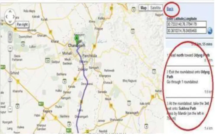
The web application named as 'Tracking System' is shown in figures that stands for the complete production of the organization.. In this system two applications are developed that are joined to each other. First one is applied to beat the initial status of the vehicle (starting point) and as the system will have the different coordinates (longitude and latitude) switching to the next one will be sufficed to find the distance travelled b/w the two sides. The application will run on WAMP server and will work but if the internet is in employment. WAMP server homepage is shown in the diagram.
5.1 Various features of web Application are:
> Both the applications are user friendly.I.e. New users can be easily comfortable.
> Since the applications are HTML based user can easily modify according to his requirements > Gives the exact location of the target.
> The applications also alerts about the distance travelled by the target and also the routes that are possible to reach to the target.
Fig. 4 System Application 1
Figure shows the first application where location will be found .As shown in figure by clicking on the 'next' button will open up next page, where the route and the distance travelled will be found. And by clicking on the 'Back'
[Pal, 6(1) January-March 2016] ISSN: 2277-5528 Impact Factor: 3.145
Int.J. of Engg. Sci & Mgmt. (IJESM), Vol. 6, Issue 1: January-March 2016 15-19
button will open up first one (page) as suggested in the Both the applications are HTML based. PHP is also used for some modifications.
6. CONCLUSION AND FUTURE SCOPE
The project is all about controlling theft of a vehicle. The system is about making the vehicle more secure by the use of GPS, GSM technology and a web application. The simulation is done by PROTEUS software. It can also be beneficial for:
1.Parents to look after their children. 2.To track animals in jungles 3.Delivery services
4.Cops department and fire services
This project can be further enhanced by the use of camera and by developing a mobile based application to get the real time view of the vehicle instead to check it on PC, which would be more convenient for the user to track the target.
REFERENCES
[1] El-Medany,W.;Al-Omary,A.;Al-Hakim,R.;Al-Irhayim,S.;Nusaif,M.,"A Cost Effective Real-Time Tracking System Prototype Using Integrated GPS/GPRS Module," Wireless and Mobile Communications (ICWMC), 2010 6th International Conference on,vol.,no.,pp.521,525,20-25 Sept.2010
[2] Hu Jian-ming; Li Jie; Li Guang-Hui, "Automobile Anti-theft System Based on GSM and GPS Module," Intelligent Networks and Intelligent Systems (ICINIS), 2012 Fifth International Conference on , vol., no., pp.199,201, 1-3 Nov. 2012
[3] Nagaraja, B. G.; Rayappa, R.; Mahesh, M.; Patil, C.M.; Manjunath, T. C., "Design & Development of a GSM Based Vehicle Theft Control System," Advanced Computer Control, 2009. ICACC '09. International Conference on , vol., no., pp.148,152, 22-24 Jan. 2009
[4] Fleischer, P.B.; Nelson, A.Y.; Sowah, R.A.; Bremang, A., "Design and development of GPS/GSM based vehicle tracking and alert system for commercial inter-city buses," Adaptive Science & Technology (ICAST), 2012 IEEE 4th International Conference on , vol., no., pp.1,6, 25-27 Oct. 2012
[5] Le-Tien, T.; Vu Phung-The, "Routing and Tracking System for Mobile Vehicles in Large Area," Electronic Design, Test and Application, 2010. DELTA '10. Fifth IEEE International Symposium on , vol., no., pp.297,300, 13-15 Jan. 2010
[6] Iman M. Almomani, Nour Y. Alkhalil, Enas M. Ahmad, Rania M. Jodeh "Ubiquitous GPS Vehicle Tracking and Management System", IEEE Jordan Conference on Applied Electrical Engineering and Computing Technologies (AEECT) 2011
[7] Abed khan M.E.(Student), , Ravi Mishra, "GPS - GSM Based Tracking System" SSCET, CSVTU, Bhilai, India International Journal of Engineering Trends and Technology- vol.3,no.,pp,161-164, 2012
[8] El-Medany, W.M.; Alomary, A.; Al-Hakim, R.; Al-Irhayim, S.; Nousif, M., "Implementation of GPRS-Based Positioning System Using PIC Microcontroller," Computational Intelligence, Communication Systems and Networks (CICSyN), 2010 Second International Conference on , vol., no., pp.365,368, 28-30 July 2010
[9] Iman M. Almomani, Nour Y. Alkhalil, Enas M. Ahmad, Rania M. Jodeh "Ubiquitous GPS Vehicle Tracking and Management System", IEEE Jordan Conference on Applied Electrical Engineering and Computing Technologies (AEECT) 2011
[10] Lita, I.; Cioc, I.B.; Visan, D.A., "A New Approach of Automobile Localization System Using GPS and GSM/GPRS Transmission," Electronics Technology, 2006. ISSE '06. 29th International Spring Seminar on , vol., no., pp.115,119, 10-14 May 2006
[11] Parvez, M.Z.; Ahmed, K.Z.; Mahfuz, Q.R.; Rahman, M.S., "A theoretical model of GSM network based vehicle tracking system," Electrical and Computer Engineering (ICECE), 2010 International Conference on , vol., no., pp.594,597, 18-20 Dec. 2010
[12] Sadagopan, V.K.; Rajendran, U.; Francis, A.J., "Anti theft control system design using embedded system," Vehicular Electronics and Safety (ICVES), 2011 IEEE International Conference on, vol., no., pp.1, 5, 10-12 July 2011
[13] www.htmlgoodies.com [14] http://maps.google.com/
[15] GSMWorld.[Online].Retrieved 15/7/2010 available:http://www.gsmworld.com/technology/faq.shtml [16] SIM 300 data sheet, SIM 300-HD_V1.06