DAMOCLES
DEBRISFALL ASSESSMENT IN MOUNTAIN CATCHMENTS
FOR LOCAL END-USERS
Contract No EVG1 - CT-1999-00007
COMPARING DEBRIS FLOW RELATIONSHIPS
IN THE ALPS AND IN THE PYRENEES
José M. García-Ruiz, Santiago Beguería, Adrián Lorente & Carlos Martí Instituto Pirenaico de Ecología, CSIC, Campus de Aula Dei, Apartado 202,
Within the DAMOCLES Project, two reports have been produced on debris flow relationships. One has been made by Crosta et al. (2001) using information from the Italian Alps. The other is the result of field and statistical work using information from the Central Spanish Pyrenees (Lorente et al., 2001). Neverthelss, their contents are extremely different due to differences in the study area, types of debris flows and statistical approaches. In spite of that, this report will try to compare the main characteristics and relationships in two mountain environments, very much affected by the occurrence of debris flows.
Both in the Italian and Spanish mountains, debris flows are one of the most powerful mechanisms for transporting material downslope, as it has been reported by, for instance, Deganutti et al. (2000), Calcaterra et al. (2000), Baroni et al. (2000) and Guzzetti et al. (1999) in the Italian Alps, and by García-Ruiz & Puigdefábregas (1982), García-Ruiz et al. (1988) and Martínez-Castroviejo & García-Ruiz (1990). This is especially true in the Alps and in the Pyrenees, due above all to the steep slopes, the high production of debris accumulated in the hillslopes as colluvium or in the channels, the characteristics of some lithological outcrops and, finally, to the relatively frequent occurrence of high intensity rainstorms.
Debris flows are a well known geomorphic process all over the World, as can be seen in the map presented by Innes (1983). In fact, many authors consider that debris flows are the most active geomorphic hazard in mountain areas, affecting human settlements, infrastructures and touristic resorts (Takahashi et al., 1981). Many papers even report the loss of lives, both in developed and in developing countries. This is the reason why many studies have been devoted to identify the factors that trigger debris flows and to understand the relationships between these factors. There is a general agreement in the definition of two essential parameters in order to establish debris flow hazards: first of all, the volume of material carried out by debris flows, and, secondly, the distance travelled by debris flows (especially the runout distance). As it was pointed out in other report within the DAMOCLES Project (Lorente et al., 2001), this information is especially relevant for debris flow modelling and to predict which areas will most probably be affected in the future. Blijenberg (1998) also stresses the crucial importance of displacement, runout and volume.
The comparison of the Italian and Spanish reports on debris flow relationships reveals the existence of few points in common. It is important to take into account
that the studied Alpine and Pyrenean debris flows are quite different. The differences can be summarized in
i) The characteristics of the materials involved,
ii) The topographic, climatic and land use characteristics of the study areas, iii) The types of debris flows studied,
iv) The type of analysis of the information recorded
The materials involved are quite different in the Alps and in the Pyrenees. The study area in the Alps corresponds to the eastern side of the Lario Lake (Lombardy Region, Northern Italy), composed above all by massive limestones, covered and mantled in the gentler sloping areas with thick glacial deposits. Occasionally, there are outcrops of conglomerates and quartzites. In the case of the Central Pyrenees the study area corresponds especially to the Flysch Sector, with thin layers of alternating sandstones and marls. Debris flows are also possible in other lithologies (calcareous screes), but their density is much higher in the Flysch, where most of analysis have been made. The main difference with the Alps consists in the presence of a higher proportion of fine material within the debris in the Flysch Sector.
The rest of environmental characteristics are also different. For instance, (i) slopes are steeper in the Alpine study area than in the Pyrenean Flysch; (ii) the range of altitudes is much higher in the Alps, where the study area ranges between 200 and 1830 m; (iii) mean annual precipitation is much higher in the lower part of the Alpine study area (1450 vs 800 mm), while is higher in the upper part of the Pyrenean study area (2000 vs 1650 mm). (iv) Land uses are also quite different: The Lario Lake area in the Alps is mainly covered by dense forests, with discontinuous meadows and terraced fields. In the Flysch Sector the sunny aspect is occupied by old abandoned fields subject to a process of plant recolonisation with dense shrubs, and the shady aspect is occupied by forests. Most of debris flows occur in the sunny aspect.
The debris flows studied in both areas represent two patterns of massive displacement of debris. Those studied in the Alps correspond to valley-confined debris flows, that originate in scars at the head of a torrent and circulate along the torrent channel as different surges. They very much depend on the availability of debris in the channel, so they are not easily related to the rainfall features (Zimmermann et al., 1997). Thus, in the Alps they occur mainly in summer (between June and September; in autumn they do not occur surely because of the unavailability of sediment after the summer debris flows (Deganutti et al., 2000; see also Zimmermann et a., 1997). In general, they arrive to an alluvial fan or a debris fan,
where they develop the runout distance. According to Hungr et al. (1984) one of the problems detected in debris flow relationships is that many predictions of the debris flow magnitude (or volume) are based on the runoff volume or peak discharge. However, it would be more logical to base the prediction on the availability of debris.
In the Pyrenees, the Flysch Sector is affected by both valley-confined and unconfined debris flows. The study has been focused on unconfined debris flows, though examples of valley confined debris flows were studied previously to the approval of the DAMOCLES Project (Martínez-Castroviejo & García-Ruiz, 1990), due to their large influence on the dynamics of braided rivers. Unconfined debris flows start as shallow landslides and occur in previously non incised hillslopes, triggered in slopes with abundant non-consolidated sediments, steep gradients and scarce plant cover (Brunsden, 1979). Scars develop at the rupture area, producing a shallow landslide that immediately evolves into a debris flow (Bathurst et al., 1997). Lateral levees (accompanying or not an incised channel developed during the scouring of the debris) occur in the middle and lower part, that ends in a frontal lobe with imbricated, non-sorted clasts (Varnes, 1978; Johnson & Rodine, 1984).
Obviously, volume, velocity and behaviour of the debris mass are so different that one could expect that the main relationships obtained in valley-confined and unconfined debris flows would be almost impossible to compare. Furthermore, there is another problem: the parameters that can be measured in both types of debris flows are very different and so the available information (in the form of tables) can not produce, sauf exceptions, comparable equations. For example, in valley-confined debris flows the source of sediment (i.e., the scar) is more disperse than in unconfined debris flows, since in the former ones sediment can arrive to the channel from small instable areas in the talus itself or from a series of scars located at different altitudes in a torrential basin. On the contrary, in the case of unconfined debris flows the source area of sediment is clearly localised, in general, in a unique scar.
Nevertheless, there are some points of accordance:
- The volume of the debris flow is a relatively important characteristic in determining the length and runout of the debris flow, especially in the Alps.
- The size (or volume) of any future debris flow is extremely difficult to assess, and then a very high uncertainty is always present in any predictive study. In fact, Rickenmann (1999) points out that debris flows are a too much complex
geomorphologic (and hydrological) process, and for this reason numerical simulation is still very difficult to use for practical applications.
- Different environmental features are favouring both in the Alps and in the Pyrenees, as everywhere in the World. This is the case for the gradient and the volume and intensity of rainfall. On the opposite, there are no coincidence in the role of the forest cover. For example, in the Pyrenees almost no debris flows occur under forest cover (and many in shrub and old, already abandoned farmed areas, wheras in the Alps they occur frequently in forest areas.
- Both reports agree in the importance of modelization to predict the spatial hazard of debris flows. One simple possibility to model parameterisation is to establish relationships between the most important and significant debris flow parameters, in order to determine the beginning of sedimentation, the runout distance and the volume.
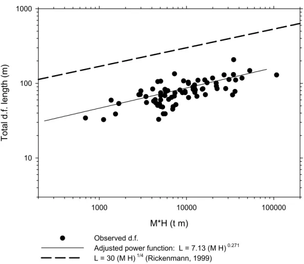
M*H (t m) 1000 10000 100000 To ta l d .f. le ng th (m ) 10 100 1000 Observed d.f.
Adjusted power function: L = 7.13 (M H) 0.271
L = 30 (M H) 1/4 (Rickenmann, 1999)
Figure 1. Plot of the total length of debris flow vs. the available potential energy (represented by the M H factor). The adjusted power function is also represented,
along with the Rickenmann (1999) relationship.
In general, there are many difficulties to compare valley-confined and unconfined debris flows. Fig. 1, for example, plots the total length of debris flows vs. potential energy (M H factor) including the results from the Spanish Pyrenees and the Rickenmann's (1999) relationship. The differences are obvious because the adjusted power function from Rickenmann is clearly over that from the Pyrenean debris flows. That means that, according to the Rickenmann's equation, with the same volume of debris the valley-confined debris flows undergo a larger displacement than unconfined, Pyrenean debris flows. This is probably a logical or expectable result, since the displacement of a debris flow (and its runout) is highly sensible to the water content (Chau et al., 2000), and it is obvious that, in general, the valley-confined debris flows are likely to have higher water discharges than the hillslope debris flows.
The Rickenmann's relationship between the debris flow length and the available potential energy is
L = 30 (MH)1/4
where L is the total length of the debris flow (m), M is the debris flow mass and H is the difference in height between the highest point of the debris flow (the scar) and the lowest end at the debris fan (m).
For the Pyrenean debris flows this relationship is expressed by
L = 7.13 (M H)0.271
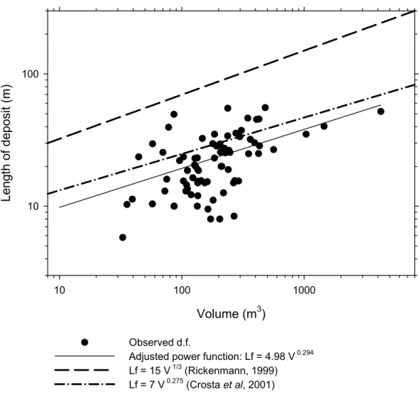
Nevertheless, when the debris flow deposit length (runout distance) is plotted vs the total volume, no especial differences can be found between the Alpine (Crosta, 2001) and the Pyrenean debris flows (Lorente et al., 2001).
Fig. 2 shows that the Rickenmann's (1999) adjusted theoretical function is again over the empirical functions, and that the Alpine and Pyrenean debris flows are relatively close one to the other.
The Rickenmann's function is expressed as
Lf= 15 V1/3
where Lf is the runout distance (m) and V is the debris flow volume (m3). Nevertheless, Rickenmann (1999) do not recommend the use of this equation for practical applications, given the great differences between the predicted and observed values.
Volume (m3) 10 100 1000 Le ng th o f de po sit ( m ) 10 100 Observed d.f.
Adjusted power function: Lf = 4.98 V 0.294
Lf = 15 V 1/3 (Rickenmann, 1999)
Lf = 7 V 0.275 (Crosta et al, 2001)
Figure 2. Plot of the debris flow deposit length vs. the total volume, along with the adjusted power function and the relationships by Rickenmann (1999) and Crosta et al.
(2002).
In the case of the Alps (Crosta et al., 2001) all the measured debris flows plot below the relationship proposed by Rickenmann and are fitted by the equation:
Lf = 7 V0.275
And for the Pyrenean debris flows the adjusted power curve has the form:
Lf= 4.98 V0.294
This expression is relatively similar to that of Crosta et al. (2001), also shown in Fig. 2. It is interesting, however, to note that the Pyrenean debris flows produce an adjusted power function located slightly below than that from the Alpine debris flows, confirming that confined debris flows are able to travel further than unconfined debris flows.
Other parameters are very difficult to compare, given the characteristics of each type of debris flows. This is the case for the relationships trying to explain the gradient at which deposition starts (around 17º in the debris flows developed in the Pyrenean Flysch Sector; 10º according to Hungr et al., 1984), or those that try to predict the runout distance. Probably, most of the debris flow parameters are more likely to be measured in unconfined debris flows. On the other hand, in valley-confined debris flows most of the relationships have been established between characteristics of the whole catchment (i.e., area, plant cover, lithology) and debris flow parameters, what increases uncertainty, due to the heterogeneity of many mountain catchments, even if they are of small size. According to Rickenmann (1999), The evaluation of, for instance, the debris flow volume using the morphometric features of a catchment as predicting factors is very limited since the equations tend to overestimate the debris flow volume, even by a factor of 100.
References
Baroni, C., Bruschi, G. & Ribolini, A. (2000): Human-induced hazardous debris flows in Carrara marble basins (Tuscany, Italy). Earth Surface Processes & Landforms, 25: 93-103.
Bathurst, J.C., Burton, A, & Ward, T.J. (1997): Debris flow run-out and landslide sediment delivery model tests. Journal of Hydraulic Engineering, 123: 410-419. Blijenberg, H. (1998): Rolling stones? Triggering and frequency of hillslope debris
flows in the Bachelard Valley, Southern French Alps. Universiteit Utrecht, 223 pp., Utrecht.
Brunsden, D. (1979): Mass movements. In Process in Geomorphology (C. Embleton & J. Thornes, eds.). E. Arnold, pp. 131-186, London.
Calcaterra, D., Parise, M., Palma, B. & Pelella, L. (2000): Multiple debris flows in volcaniclastic materials mantling carbonate slopes. In Debris flow hazards mitigation: Mechanics, prediction and assessment (G.F. Wieczorek and N.D. Naeser, eds.), Balkema, pp. 99-108, Rotterdam.
Chau, K.T., Chan, L.C.P., Luk, S.T. & Wai, W.H. (2000): Shape of deposition fan and runout distance of debris flow: Effects of granular and water contents. In
Debris-flow hazard mitigation: Mechanics, prediction and assessment (G.F. Wieczorek & N.D. Naeser, eds.), Balkema, pp.387-396, Rotterdam.
Deganutti, A.M., Marchi, L. & Arattano, M. (2000): Rainfall and debris flow occurrence in the Moscardo basin (Italian Alps). In Debris-flow hazard mitigation: Mechanics, prediction and assessment (G.F. Wieczorek & N.D. Naeser, eds.), Balkema, pp. 67-72, Rotterdam.
García-Ruiz, J.M. & Puigdefábregas, J. (1982): Formas de erosión en el flysch eoceno surpirenaico. Cuadernos de Investigación Geográfica, 8:85-130.
García-Ruiz, J.M., Arnáez, J., Ortigosa, L. & Gómez Villar, A. (1988). Debris flows subsequent to a forest fire in the Najerilla River Valley (Iberian System, Spain).
Pirineos, 131:3-24.
Guzzetti, F., Carrara, A., Cardinali, M. & Reichenbach, P. (1999): Landslide hazard evaluation: A review of current techniques and their application in a multi-scale study, Central Italy. Geomorphology, 31: 181-216.
Hungr, O., Morgan, G.C. & Kellerhalls, R. (1984): Quantitative analysis of debris torrent hazards for design of remedial measures. Can. Geotech. J., 21: 663-677. Innes, J.L. (1983): Febris flows. Progress in Physical Geography, 7 (4): 469-501. Johnson, A.M. & Rodine, J.R. (1984): Debris flow. In Slope instability (D. Brunsden
& D.B. Prior, eds.). Wiley, pp. 257-362, Chichester.
Lorente, A., Beguería, S & García-Ruiz, J.M. (2001): Debris flow characteristics and relationshisps in the Central Spanish Pyrenees. Report for DAMOCLES Project, 14 pp., Zaragoza.
Martínez-Castroviejo, R. & García-Ruiz, J.M. (1990): Coladas de piedras (debris flows) y dinámica fluvial en ríos torrenciales del pirineo Central: El caso del río Ijuez. Cuadernos de Investigación Geográfica, 16: 55-72.
Rickenmann, D. (1999): Empirical relationships for debris flows. Natural Hazards,
19: 47-77.
Takahashi, T. (1981): Estimation of potential debris flows and their hazardous zones; soft counrtermeasures for a disaster. J. Nat. Disaster Sci., 3 (1): 57-89.
Varnes, D.J. (1978): Slope movements, type and processes. In Landslide analysis and control (R.L. Schuster & R.J. Krizec, eds.), Transportation Research Board, National Academy of Sciences, Special Report 176, pp. 11-33, Washington D.C. Zimmermann, N., Mani, P. & Romang, H. (1997): Magnitude-frequency aspects of