Prehistoric Avenues and Alignments
On 1st April 2015 the Historic Buildings and
Monuments Commission for England changed its
common name from English Heritage to Historic
England. We are now re-branding all our documents.
Although this document refers to English Heritage,
it is still the Commission's current advice and
guidance and will in due course be re-branded as
Historic England.
Please see our website
for up to date contact information, and further
advice.
We welcome feedback to help improve this document, which will be
periodically revised. Please email comments
to
[email protected]
We are the government's expert advisory service for England's historic environment.
We give constructive advice to local authorities, owners and the public. We champion
historic places helping people to understand, value and care for them, now and for the
future.
Introductions to
Heritage Assets
Prehistoric Avenues
and Alignments
2
Introductions to Heritage Assets
English Heritage Prehistoric Avenues and Alignments
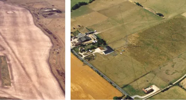
Fig. 1. The plough-levelled north-eastern terminal of the Dorset Cursus, surrounded by a range of earthwork and levelled archaeological sites.
Fig. 2. The southern terminal of the cursus known as Drayton South, Oxfordshire. Several ring ditches are also visible.
INTRODUCTION
There are several types of prehistoric monument
particularly notable for their length. This document
is mainly concerned with the most numerous and
widespread – cursus monuments. Two other types –
avenues and stone alignments – are dealt with more
briefly towards the end of the document.
Cursus monuments or enclosures are one of the most
enigmatic types of site that we can see in the British
landscape – ‘These British Nasca lines – staggering and
frustrating by turns’, in the words of archaeologist and
cursus expert Roy Loveday. ‘Staggering’ relates mainly
to their size, which can be considerable, with
the longest known example approaching 10 kilometres;
‘frustrating’ refers to the great variety present among
apparently similar monuments, and to efforts to
understand precisely what they were for – many
theories about their likely functions are difficult to
apply generally, simply because there is greater diversity
among cursus monuments than is commonly realised.
Cursus monuments are widely distributed throughout
the British Isles, most, since the class was first
tentatively identified in the 1930s, discovered through
aerial photography. Few feature any visible
above-ground remains.
DESCRIPTION
Cursus monuments are, for the most part, long and relatively narrow earthwork enclosures. They are generally defined by an enclosing bank with a ditch on the outside. Similar monuments featuring lines of pits or post holes rather than banks and ditches are so far largely confined to Scotland.
Cursus monuments range in length from the 10 kilometres or so of the Dorset Cursus (Figure 1) down to around 100 metres, although there is no precise lower limit. Instead, there is a problem. Most monuments of this early date – the Neolithic period (about 4000 - 2500 BC) – tend to lack surviving above-ground remains, and have generally been discovered as cropmark sites on aerial photographs, or in the course of gravel extraction, development and other ground-disturbing activities. Consequently, at the lower end of the size range, it becomes very difficult to distinguish an eroded cursus from, say, an equally eroded long mortuary enclosure or even some types of long barrow.
The width of cursus monuments varies across the class as a whole and within individual monuments. There is no set, or even approximate, relationship between length and width.
For example, the Greater Stonehenge Cursus (Wiltshire) is around 3 kilometres long, and its width varies between 100 metres and 150 metres. In contrast, the Stanwell Cursus (Surrey) is more than 3 kilometres long but the ditches are generally little over 20 metres apart. Despite appearances, the sides tend not to be parallel. Indeed, given the nature of the terrain many cross, it would be a remarkable achievement if they were. In some cases, one side seems markedly straighter and more regular than the other. In many cases it is impossible to see from one end to the other, and also to see both ends from any particular point in the interior.
In some cases, but by no means all, the enclosing earthworks are breached by causeways – areas of ground across which the ditch has not been dug, and the accompanying bank has not been built – presumably to allow people to pass into and out of the enclosed area, although some causeways have proved to be extremely narrow. However, a simple gap seems to be as sophisticated as it gets – there are few indications of formal entrances or entrance structures. These gaps or causeways tend to occur along the sides of cursus monuments, and not through the terminals, or ends.
Fig. 3. The plough-levelled Stonehenge Lesser Cursus, Wiltshire, showing as a soil mark. Fig. 4. Stonehenge, viewed from the north-east, with the final stretch of the Avenue ap-proaching the monument from the bottom of the photograph.
The terminals may be rounded, straight with right-angled corners, straight with curved corners, or completely open, for example. In some cases, such as Scorton in North Yorkshire, and Stanwell, Surrey, the internal banks are replaced (or accompanied) by a central linear mound, something that serves to emphasize a possible link with bank barrows, or at least to underline the difficulties of classifying damaged and eroded monuments on the basis of shape and size only. Other possible variants include pit or post-defined structures at Bainton and Godmanchester, both in Cambridgeshire.
Cursus monuments often occur singly, but are also known in pairs or larger groups. At Rudston in east Yorkshire, there may be as many as five converging in the vicinity of a large standing stone, while the longest example, the Dorset Cursus, is in fact two (and some have suggested three) cursus monuments laid out end to end.
Some cursus monuments incorporated existing monuments, usually long barrows, into their earthworks – a long barrow occurs along the northern side of the Dorset Cursus – but internal structures contemporary with the cursus itself are uncommon, although one has to bear in mind the size of these monuments compared to the limited areas that have been excavated. The relationship with long barrows is an intriguing one. For example, both the Dorset Cursus and the Greater Stonehenge Cursus were orientated on pre-existing long barrows, but in both cases the relevant cursus terminals were markedly larger in scale than the rest of the cursus, and resembled long barrow mounds themselves. In fact, in the 19th century Canon William Greenwell dug into one of end of the Rudston ‘A’ cursus in the belief that he was indeed excavating a long barrow.
As far as function is concerned, the scarcity of finds from excavations is unhelpful, but generally cursus monuments have been thought of as paths or processional ways, although whether they represented the enclosure or monumentalisation of an existing path or route, or marked something new in the landscape is open to debate. However, they generally appear to have been closely integrated with the landscape that they were constructed across, both in terms of the natural topography and pre-existing monuments. They could, also, have served to
demarcate or even act as a barrier between different landscape zones. It is also clear that celestial alignments could have been of some significance – the earliest section of the Dorset Cursus appears to have been orientated on midwinter sunset, for example. Consequently, understanding of individual sites needs to draw considerably on an understanding of their local setting.
CHRONOLOGY
Only recently have archaeologists begun to get a firm grasp on when cursus monuments were first constructed and used. In the past, uncertainty arose for several reasons. For example, when excavated, cursus earthworks have been relatively unproductive in terms of diagnostic artefact types, with objects relating to later re-use being a notable source of confusion. A spatial relationship with later Neolithic henge monuments led some to suggest that cursus monuments were either contemporary with, or perhaps later than, henges. Some early radiocarbon dates also blurred things somewhat. For example, a mid-3rd millennium BC date from antler recovered from the ditch of the Greater Stonehenge Cursus in the 1940s has now been clearly shown to relate to an episode of re-use around a millennium after the cursus ditch was originally dug.
Radiocarbon dates obtained from several sites over the last twenty years or so indicate that earthwork cursus monuments were probably constructed somewhere in the period 3600 to 3000 BC, with the most recently obtained dates tending to focus on the earlier part of this period, that is 3600 to 3300 BC. This suggests that they are generally later than many long barrows and megalithic tombs, and a little later than the initial construction of most causewayed enclosures. Interestingly, the post- or pit- defined Scottish examples are tending to produce earlier dates, focusing on the period 4000 to 3600 BC.
On sites which have seen the most investigation, it is not unusual to find clear evidence of re-use, for example in the form of recutting the ditch perhaps a millennium or more after the monument was originally constructed. That cursus monuments retained significance in the landscape long after their original use is demonstrated by the frequency with which later monuments, including henges and round barrows, cluster
Introductions to Heritage Assets
English Heritage Prehistoric Avenues and Alignments 4
Fig. 5. The Sanctuary, near Avebury, Wiltshire. The south-east end of the West Kennet
Avenue can be seen emerging from the outer stone circle on the bottom right. Fig. 6. Stone alignment on Longash Common, Dartmoor, Devon.
around them (Figure 2). Indeed it is not uncommon to find later monuments being built within cursus monuments – for example, both the Dorset Cursus and the Greater Stonehenge Cursus saw Bronze Age round barrows built inside them.
DEVELOPMENT OF THE ASSET TYPE
AS REVEALED BY INVESTIGATION
The name ‘cursus’ was first suggested as long ago as 1723 by the antiquarian William Stukeley, with reference to the Greater Stonehenge Cursus, which he compared to a Roman chariot race track. Otherwise these extremely elongated enclosures managed for the most part to escape archaeological attention until the 1930s when Major GW Allen, an aerial photographer active in the Thames Valley, showed some cropmarkphotographs to the leading archaeologist ET Leeds at the Ashmolean Museum, Oxford. Leeds published them in 1934 in a brief note entitled ‘Rectangular enclosures of the Bronze Age in the upper Thames valley’, although despite the title, he seemed wary of assigning a date. After describing the sites he concluded that ‘Of the purpose of these interesting enclosures we have as yet no evidence.’ The following year, OGS Crawford, the Ordnance Survey’s Archaeology Officer, suggested that there might be some link between these Thames Valley examples and the ‘so-called Stonehenge cursuses’, there being two such enclosures at the latter site – the Greater and Lesser Stonehenge Cursuses (Figure 3).
Nearly two decades on, in his book Neolithic Cultures of the British Isles (1954), the leading prehistorians Stuart Piggott devoted less than a page out of nearly 400 to cursuses and related monuments – known examples still largely restricted to the Thames Valley and the Stonehenge area – but did argue that ‘they certainly are to be placed somewhere in the Neolithic’. Numbers gradually increased as civilian aerial photography steadily developed and expanded during the decades after the Second World War, a process that also considerably broadened the known distribution.
Their sheer length was a contributory factor in the delayed recognition of cursus monuments as a distinct class. Soil conditions and land use are rarely constant over the full length of a single monument, making it rare for an entire cursus to be visible as a cropmark on any single occasion. Likewise it may not be apparent that a length of ditch exposed in quarrying or development may actually be part of something several kilometres long. On the other hand, it took a century and a half for the various fragments of surviving earthwork along the course of the Dorset Cursus to be recognised as constituent parts of a single monument. As late as the 1930s, the south-western terminal, surviving as a three-sided earthwork, was the scene of an excavation looking for the ‘missing’ fourth side of what was thought to be a square enclosure. It was, of course, inconceivable at the time that the missing side might be 10 kilometres away.
ASSOCIATIONS
Cursus monuments have important associations with a range of other categories of archaeological monument. Most of the major ones have been described above. Some are aligned on existing long barrows or incorporate them within their earthworks. At Fornham All Saints in Suffolk, a cursus known only as a cropmark, and featuring marked changes of direction along its 1.9 kilometre course, appears to cut across a pair of conjoined causewayed enclosures, suggesting that the cursus is later in date. In contrast, recent analysis of radiocarbon dates suggests that construction of the Drayton cursus may just have begun before the nearby Abingdon causewayed enclosure. At Springfield Lyons, Essex, excavations uncovered a circle of spaced post-holes within one of the terminals, suggesting a timber circle had originally stood there. However, it was impossible to determine for sure which came first, although on balance it seems most likely that the circle was built after the cursus, but probably not too long after.
A number of sites were foci for construction of ceremonial and funerary monuments during the 3rd and earlier 2nd millennia BC – the late Neolithic and Early Bronze Age – with a wide variety of henges, hengiforms and round barrow types represented. That cursus monuments could continue to influence activity and land use a considerable time after construction is provided clearly by those that survive best – both the Greater Stonehenge Cursus and the Dorset Cursus were utilised in the laying out of field systems in the 2nd and 1st millennia BC.
OTHER FORMS OF
AVENUES AND ALIGNMENTS
The term avenue is used to describe particular forms of approach to prehistoric monuments, usually either connecting one monument with another, or with a particular landscape feature. This is not, therefore, a particularly coherent group of monuments. The best known example is probably the earthwork avenue, comprising parallel lines of bank with external ditch, which connects Stonehenge to the River Avon. The Stonehenge Avenue (Figure 4) heads north-east from the monument before turning eastwards and, eventually, south-east towards the river, its total length approaching 3 kilometres. Its precise place within Stonehenge’s lengthy development has been a matter of debate, but recent analysis suggests that it was first constructed somewhere in the period 2600 to 2400 BC, broadly contemporary with the construction of the main sarsen structures within Stonehenge itself. It had previously been thought to belong to a much later phase. The stretch of the Avenue connected with Stonehenge itself shares the latter’s general alignment on midsummer sunrise and midwinter sunset. Recent excavations suggest that the Avenue actually incorporates some periglacial features that share this alignment, implying that a natural phenomenon, probably visible on the surface during the Neolithic, may have played a role in the location of Stonehenge itself.Several functions have been suggested for the Stonehenge Avenue, none mutually exclusive. One of the best known is that the earthworks of the Avenue demarcated or formalised the route along which some or all of the stones used to construct Stonehenge were hauled, having been brought at least part of the way by river. More recently it has been suggested that the Avenue also connected Stonehenge to the much larger Durrington Walls henge, which lies just a few kilometres to the north-east. Excavations at the latter have shown that it too was connected by an avenue to the Avon. The Durrington avenue was around 100 metres long and some 30 metres wide, with a low bank running along each side. It seems to have been surfaced with rammed flint plus animal bone and pottery, and bore signs of being heavily trampled. It was also aligned on midsummer sunrise. It has been suggested that Durrington Walls was where people lived while constructing Stonehenge, and the scene for feasting. It is also suggested that there was a funerary aspect to the journey between the two monuments.
The other prehistoric avenues also, intriguingly, tend to be associated with the larger henge monuments. There are cropmark indications that the henge enclosure at Mount Pleasant, just outside Dorchester in Dorset, was linked in some way to the River Frome, although this is speculative at present. Better known are the two stone-lined avenues associated with the henge at Avebury. The West Kennet Avenue is over 2 kilometres long and connects Avebury with another Late Neolithic monument known as The Sanctuary (Figure 5), although the full course of the Avenue itself is not known. Two broadly parallel lines of upright sarsens head south from the Avebury henge. Likewise, two parallel lines of standing stones emerge from The Sanctuary. However, the middle section of this Avenue is, at present, unlocated, with recent excavations failing to find stoneholes in an area where it was presumed sarsens once stood.
In contrast, the other example at Avebury – the Beckhampton Avenue – was long regarded with suspicion until recent excavations uncovered buried sarsens and stone holes. It had been described by the antiquary William Stukeley in the early 18th century, but no stones were visible above the ground and there had been little in the way of documentary support for Stukeley’s account.
Few other examples of such avenues are known or have been claimed. One timber example has been excavated, however, with intriguing results. Comprising paired lines of spaced postholes, it was located on Ogden Down, on Cranborne Chase in Dorset. It proved to be considerably later than the monuments it was linked to – two ring ditches dating to the late Neolithic or Early Bronze Age were linked by a timber avenue that dated to the Late Bronze Age.
The two Avebury stone avenues emphasize a problem
common to prehistoric archaeology – the difficulty in identifying clear distinctions between apparently different types of
monument. There are obvious resemblances to other forms of standing stone monument, in particular stone alignments. These are, as the name suggests, linear rather than circular arrangements of standing stones. The term is generally applied to instances where three or more standing stones have been placed in a line, and a single monument may comprise one row or alignment, or two or more broadly parallel lines. Dating evidence is, as with most forms of standing stone monument, quite poor but most are believed to belong broadly to the later Neolithic or Early Bronze Age (about 3000BC – 1500BC). In England, stone alignments comprising more than two rows are clustered on Exmoor and Dartmoor (Figure 6), with most featuring three lines of stones. As with single and double rows, there is no clear evidence for the heights of stones being graded along the length of the line, although terminal stones may be higher. Spacing between the stones may also be variable.
Introductions to Heritage Assets
English Heritage Prehistoric Avenues and Alignments 6
FURTHER READING
The most accessible introduction to cursus monuments is Roy Loveday, Inscribed Across The Landscape: The Cursus Enigma
(2006). Aspects of the phenomenon are dealt with in more detail, including regional and theoretical considerations, in A Barclay and J Harding, Pathways and Ceremonies. The Cursus
Monuments of Britain and Ireland. (1999).
For specific sites, A Barclay, G Lambrick, J Moore, and M
Robinson, Lines in the Landscape. Cursus Monuments in the Upper
Thames Valley (2003) describes excavations at the cursuses at
Drayton (Oxfordshire) and Lechlade (Gloucestershire), and discusses similar monuments in the upper Thames valley. The Stanwick Cursus and associated monuments are described in Framework Archaeology’s Landscape Evolution in the Middle Thames Valley: Heathrow Terminal 5 Excavations volume 1, Perry Oaks (2006).
Recent work at the Dorset Cursus is contained in J Barrett, R Bradley and M Green, Landscape, Monuments and Society:
The Prehistory of Cranborne Chase (1991); C French and
others, Prehistoric Landscape Development and Human Impact
in the Upper Allen Valley, Cranborne Chase, Dorset (2007); and
C Tilley, A Phenomenology of Landscape: Places, Paths and
Monuments (1994).
The most recent work at the Greater Stonehenge Cursus is summarised in J Thomas and other, ’The date of the Greater Stonehenge Cursus’, Antiquity 83 (2009), 40-53, while J Thomas, ‘On the Origins and Development of Cursus Monuments in Britain’, Proceedings of the Prehistoric Society 72 (2006), 229-41, examines the available dating evidence for cursus monuments and discusses the possible relationships between the Scottish pit and post monuments, and the more southerly earthwork sites.
The Stonehenge Avenue is described in detail in R Cleal, K Walker and R Montague, Stonehenge in its Landscape: Twentieth
Century Excavations (1995). The most recent excavations
are summarised in M Larsson and M Parker Pearson, From Stonehenge to the Baltic: living with cultural diversity in the third
millennium BC (2007). The avenues at Avebury are described
in a number of recent books, including M Gillings and J Pollard, Avebury (2004) and J Pollard and A Reynolds, Avebury:
The Biography of a Landscape (2002), with the most recent
excavations described in detail in M Gillings and others,
Landscape of the Megaliths: Excavation and Fieldwork on the
Avebury Monuments 1997-2003 (2008).
The literature on standing stone monuments is plentiful and diverse, but a useful and detailed starting point for stone alignments is Aubrey Burl, From Carnac to Callanish: The Prehistoric Stone Rows and Avenues of Britain, Ireland and
Brittany (1993). Hazel Riley and Robert Wilson-North, The
Field Archaeology of Exmoor (2001), and Nicholas Johnson
and Peter Rose, Bodmin Moor – An Archaeological Survey.
Volume 1: The Human Landscape to c1800 (1994) are just
two among many volumes that examine stone alignments among many other classes of monument within their broader landscape context.
CREDITS
Author: Martyn Barber
Cover: The Stonehenge Lesser Cursus (as Figure 3) All figures: © English Heritage.NMR.
If you would like this document in a different format, please contact our Customer Services department:
Telephone: 0870 333 1181
Fax: 01793 414926
Textphone: 01793 414878