D
EPARTMENT OFH
OMELANDS
ECURITYU
NITED
S
TATES
C
OAST
G
UARD
S
TRATEGIC
S
PECTRUM
P
LAN
D
ECEMBER
2007
EDITION
P
REPAREDP
URSUANT TO THEP
RESIDENT’
SS
PECTRUMP
OLICYI
NITIATIVETable of Contents
EXECUTIVE SUMMARY... iii
FOREWORD... iv
THE PRESIDENT’S SPECTRUM POLICY INITIATIVE... 1
1.0–U.S.COAST GUARD MISSIONS... 2
2.0–CURRENT SPECTRUM UTILIZATION... 8
3.0–EMERGING SPECTRUM REQUIREMENTS... 15
4.0–FUTURE SPECTRUM NEEDS... 36
5.0–CONCLUSION... 39
APPENDIX A–ACRONYMS AND ABBREVIATIONS... 40
Note: While this Strategic Spectrum Plan illustrates both the current and
projected use of the radio frequency spectrum by the Coast Guard, national
priorities and mission requirements are subject to change. Therefore, while
every effort has been made to provide accurate predictions for future spectrum
requirements, these requirements are subject to change.
List of Figures
Figure 1: Coast Guard Missions ... 3
Figure 2: Electromagnetic Spectrum ... 3
Figure 3: Federal Frequency Assignments ... 4
Figure 4: International VHF Maritime Spectrum ... 6
Figure 5: VHF Maritime Spectrum in the U.S. after Reallocations and Auctions ... 6
Figure 6: Coast Guard in Action... 7
Figure 7: Global Maritime Distress and Safety System... 9
Figure 8: Typical VTS Control Station... 12
Figure 9: DEEPWATER ASSETS ... 16
Figure 10: High-Level DEEPWATER Asset Connectivity and Communication Links ... 21
Figure 11: Rescue 21 Offshore Communications... 25
Figure 12: Global Hawk High Altitude Long Endurance (HALE) UAV ... 27
Figure 13: Over-the-horizon propagation ... 31
List of Tables
Table 1: Frequency Bands ... 4Table 2: Commercial SATCOM Services ... 17
Table 3: VHF Communication Capabilities ... 18
Table 4: UHF Communication Capabilities ... 18
Table 5: UHF MILSATCOM Services... 19
Table 6: HF/HF ALE Capabilities ... 19
Table 7: Iridium Satellite Phone Capabilities ... 20
Table 8: VHF Communications ... 20
Table 9: C-Band 3D RADARs ... 21
Table 10: Sensor Spectrum Requirements... 23
Table 11: Rescue 21 VHF and UHF Communications... 26
Table 12: Additional AIS Channels... 27
Table 13: UAV Communication & Sensor Capabilities... 28
Table 14: Container Tracking ... 30
Table 15: HF Radar... 32
Table 16: Mobile-Satellite Usage ... 32
Table 17: Blue Force Tracking ... 33
F
OREWORDThe 2007 Coast Guard Strategic Spectrum Plan is an update from the 2005 version of the plan. Below are the specifics modified, removed, or updated in each chapter.
• Removed Sensitive Security Information material
• Executive Summary: Removed reference to MDA as a separate major acquisition project • 1.0 U.S. Coast Guard Missions:
o Mission breakdown updated
o Frequency usage graph updated • 2.0 Current Spectrum Utilization
o Spectrum usage updated for the new mission breakdown
o Removed reference to GOTHAM
o Updated sections on GMDSS, HF Fax, satellite communications, public safety, vessel traffic services and racons.
• 3.0 Emerging Spectrum Requirements
o MDA program removed as an overarching acquisition program
o Reference to AEROSTAT High Altitude Platforms removed (section 3.3.4 from 2005)
o Reference to MDA Broadband data links removed (section 3.3.5 from 2005) • 3.1 Integrated Deepwater Systems
o Removed reference to Bell Eagle Eye • 3.2 Rescue 21
o Removed reference to Asset Tracking for this program
• 3.3 Nationwide AIS, 3.4 Unmanned Aerial Systems, 3.6 High Frequency Radar
o Upgrade from subject under MDA in 2005
o Several updates to AIS
• 3.5 Container Tracking and Security in U.S. Ports
o New subject based on outcome of WRC-2007 • 3.7 Mobile Satellite Usage
o New subject based on need for increased bandwidth to mobile assets • Added new sections
o 3.8 Blue Force tracking
o 3.9 HF ALE Expansion
o 3.10 Boat crew and boarding team communication
o 3.12 Enhanced Loran
o 3.13 Long Range Identification and Tracking • 4.0 Future Spectrum Needs
o Table updated based on updated to Section 3.0 • Appendix A – Acronyms and Abbreviations
T
HEP
RESIDENT’
SS
PECTRUMP
OLICYI
NITIATIVEThis United States Coast Guard Strategic Spectrum Plan has been prepared in accordance with the President’s Spectrum Policy Initiative (SPI). The Administration recognized that frequency spectrum dependent services are the backbone of the nation’s economic and national security, and therefore committed to develop and implement a SPI to foster economic growth and ensure national and homeland security.
“The existing legal and policy framework for spectrum management has not kept pace with the dramatic changes in technology and spectrum use.” President Geor e W. Bush, Presidential Memorandum, g
May 29, 2003
In June 2003, the President directed the Secretary of Commerce to chair an initiative for a comprehensive review to develop, among other things, recommendations for improving federal spectrum management policies. In June 2004, the Commerce Department, through its National Telecommunications and Information Administration (NTIA), delivered its spectrum policy recommendations. 1 Based on these reports, President Bush issued a Memorandum on November 30, 2004 that directed all federal agencies and departments to identify spectrum requirements and develop spectrum needs plans that demonstrate effective and efficient use of federal government spectrum. Specifically, the Presidential Determination: Memorandum for the Heads of Execute Departments and Agencies provided the following tasking to agencies;
(a) Within 1 year of the date of this memorandum [30 November 2004], the heads of agencies selected by the Secretary of Commerce shall provide agency-specific strategic spectrum plans (agency plans) to the Secretary of Commerce that include: (1) spectrum requirements, including bandwidth and frequency location for future technologies or services; (2) the planned uses of new technologies or expanded services requiring spectrum over a period of time agreed to by the selected agencies; and (3) suggested spectrum efficient approaches to meeting identified spectrum requirements. The heads of agencies shall update their agency plans biennially. In addition, the heads of agencies will implement a formal process to evaluate their pro-posed needs for spectrum. Such process shall include an analysis and assessment of the options available to obtain the associated communications services that are most spectrum-efficient and the effective alternatives available to meet the agency mission requirements. Heads of agencies shall provide their analysis and assessment to the National Telecommunications and Information Administration (NTIA) for review when seeking spectrum certification from the NTIA.
1
In accordance with the Communications Act of 1934, as amended, the President is responsible for the use of the frequency spectrum by radio stations belonging to, and operated by, the United States. The President delegated this authority to the Secretary of Commerce, who in turn delegated the authority to the Assistant Secretary of Commerce for Communications and Information; this Assistant Secretary serves as the Administrator of the NTIA.
1.0
–
U.S.
C
OASTG
UARDM
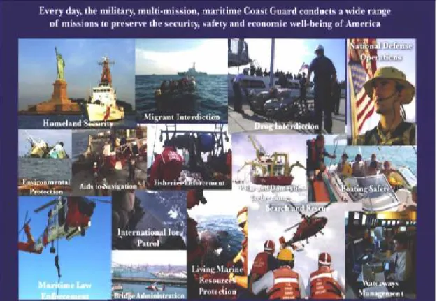
ISSIONSThe Coast Guard is a military, multi-missioned, maritime service charged with reducing America’s risk throughout the maritime domain while maximizing safety and accessibility to the economic and recreational benefits of our Nation’s waterways. As part of the Department of Homeland Security (DHS), the Coast Guard is the lead federal agency for maritime homeland security. The Coast Guard’s Mission is to protect the public, the environment, and U.S. economic interests – in the nation’s ports and waterways, along the coast, on international waters, or in any maritime region as required to support national security.
RADIO COMMUNICATIONS ARE CRITICAL TO THE COAST GUARD’S MISSIONS “We are poised …to be a linkage between the maritime forces of
this country and countries that are low tech or sometimes no tech, where it would be impossible to create a coalition and establish interoperability if it weren’t for an intermediate platform that can go both ways. … We bridge asymmetries.”
Admiral Thad Alan Commandant, United States Coast Guard November 1, 2007
Radio frequency spectrum is necessary for wireless communications – an integral part of the Coast Guard’s missions (Figure 1). Accordingly, the Coast Guard requires adequate and reliable communications capabilities in order to accomplish its missions, The Coast Guard’s eleven missions fall into three broad Roles:
MARITIME SAFETY MARITIME SECURITY
Search & Rescue Drug Interdiction
Marine Safety Migrant Interdiction
Other Law Enforcement
MARITIME STEWARDSHIP Ports, Waterways and Coastal Security
(PWCS) Aids to Navigation and Waterways
Management
Defense Readiness
Ice Operations
Marine and Environmental Protection Living Marine Resources
Figure 1: Coast Guard Missions
1.1 M
ANAGINGT
HER
ADIOS
PECTRUMThe radio spectrum is the radio frequency (RF) portion of the electromagnetic spectrum (Figure 2 and Table 1). In the United States, regulatory responsibility for the radio spectrum is divided between the National Telecommunications and Information Administration (NTIA) and the Federal Communications Commission (FCC). The NTIA administers spectrum for Federal government use, and the FCC, an independent regulatory agency, administers spectrum for non-Federal use (i.e., state, local government, commercial, private internal business, and personal use). Because of the Coast Guard Missions, it must work with both agencies: with the NTIA on Federal government spectrum issues and with the FCC on non-government spectrum issues relating to the maritime public.
| | |
VLF LF MF HF VHF UHF SHF EHF InfraredVisible Light | 10 kHz | 100 kHz | 1 MHz | 10 MHz | 100 MHz | 1 GHz | 10 GHz | 100 GHz
Table 1: Frequency Bands
Very Low Frequency (VLF) 10 kHz to 30 kHz Low Frequency (LF) 30 kHz to 300 kHz Medium Frequency (MF) 300 kHz to 3 MHz High Frequency (HF) 3 MHz to 30 MHz Very High Frequency (VHF) 30 MHz to 300 MHz Ultra High Frequency (UHF) 300 MHz to 3 GHz Super High Frequency (SHF) 3 GHz to 30 GHz Extremely High Frequency (EHF) 30 GHz and Above
Spectrum management involves all activities associated with regulating the use of the radio spectrum and it includes the structure and process for allocating, allotting, assigning and licensing the scarce resource as well as enforcing associated rules and regulations. Managing the frequency spectrum is a difficult task, and becomes much more important in the face of increasing demand. For example, the recent Commercial Spectrum Enhancement Act2 provides that the Federal Government must vacate certain frequencies so that they can be used for commercial purposes.
At the end of FY 07, the Coast Guard held more than 16,000 frequency records (assignments) making it the seventh largest Federal user of frequency assignments (Figure 3).
Government Spectrum Usage
AG 5% CG 6.5% AF 11.9% Army 14.0% C 2.7% DOE 3.4% DHS 6.6% FAA 14.9% Interior 5.9% DOJ 10.3% NASA 1.0% Navy 11.7% TVA 0.7% Treasury 0.5% USPS 1.1% VA 1.2% Others 2.5%
Figure 3: Federal Frequency Assignments
Public Law No. 108-494, Title II, Dec. 23, 2004; 118 Stat 3986.
3
An authorization is required for each frequency at each transmitter site. The Coast Guard requires a large number of radio frequency authorizations because of the unique Coast Guard maritime missions. Some activities, such as distress watchkeeping, require a disproportionate number of frequency authorizations. The Coast Guard has 651 frequency authorizations just for monitoring and operating over VHF distress Channel 16 alone. Similarly, the Coast Guard has an additional 630 frequency authorizations for maritime safety broadcasts and liaison on VHF Channel 22. Because new Coast Guard systems are increasingly technology-dependent and spectrum-dependent, the number of authorizations will only increase in the future.
Just as the Coast Guard takes a leadership role in the coordination and management of our nation’s waterways and marine transportation system, it must take a leadership role in the protection, coordination and management of the frequency spectrum to assure that vital communications frequencies are available for military, commercial and recreational use of our nation’s waterways, as well as to assure international interoperability. As a result, Coast Guard Spectrum Management is just as vitally concerned with public frequency allocations, regulated by the FCC, as it is with government frequency allocations within the province of NTIA. Coast Guard Spectrum Management attempts to assure that ample terrestrial and satellite radiocommunications channels are available for not only Coast Guard operations, but also for the commercial and recreational boaters communications needs on a national and international basis. Typically, maritime frequency allocations are made on an international basis. Generally, there is input to the International Telecommunications Union (ITU) which makes the allocation after input from the International Maritime Organization (IMO) relating to requirements.
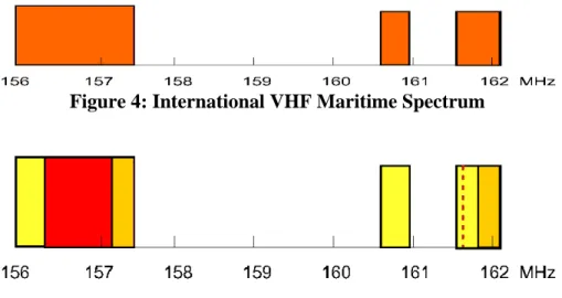
After the international allocation, the NTIA and the FCC decide what to do with the allocation domestically. For example, in the VHF (very high frequency) spectrum band, there is an international allocation for Maritime operations. Obviously some international allocation is necessary because ships travel all over the world and it is imperative that they be able to receive and transmit information, on standard frequencies, wherever they go. The international allocation for VHF Maritime frequencies is shown in Figure 4.
While this spectrum has been allocated internationally, because of reallocations of frequencies and auctions domestically (Figure 5), VHF frequencies allocated for Maritime operations in the U.S. are significantly less.
The diminishing VHF maritime allocation in the U.S. presents a good example of the need for the Coast Guard to be active with both the Federal and non-Federal frequency allocations. This specific frequency band provides the only remaining internationally interoperable VHF frequency spectrum available in the U.S. This band is used, among other things, for the Automatic Identification System (AIS). AIS is a unique maritime navigation safety communications system, providing collision avoidance functionality. Additionally, AIS can be used for vessel monitoring and tracking to enhanced maritime domain awareness.
3
There is a fee payable to the NTIA for each authorization.
Figure 4: International VHF Maritime Spectrum
Figure 5: VHF Maritime Spectrum in the U.S. after Reallocations and Auctions
The United States is establishing a national capability to receive AIS from vessels in its own waterways and those in deep sea regions approaching its shores. Tracking vessels far at sea requires technology that is capable of providing very wide areas of view. AIS can only be received from wide areas if there are no other interfering signals on AIS transmitting frequencies. Therefore, to ensure AIS remains as accurate and persistent as possible, the frequencies used by AIS must be allocated exclusively for AIS both domestically and internationally. The Coast Guard has been engaged in a long battle, not yet concluded, to obtain frequencies for AIS. To support Blue Force Tracking (BFT) and satellite detection of AIS, two additional AIS channels will be required to protect the integrity of the VHF Data Link on AIS1 and AIS2. Based upon the international interoperability requirement, the frequency spectrum for new technology must come from the remaining U.S. VHF frequency allocation.
The following Sections will discuss, in detail, the current frequency spectrum utilization and future needs of the Coast Guard to accomplish its missions. One brief example relating to the events surrounding Hurricane Katrina illustrates the success of Coast Guard Spectrum Management and communications capabilities.
Figure 6: Coast Guard in Action
Coast Guard personnel saved more than 33,500 lives in the New Orleans area following Hurricane Katrina. In all, Coast Guard personnel saved more lives during Hurricane Katrina than they did nationally in the last eight years combined.
Military.com Nov. 2, 2005
During operations in response to Hurricane Katrina, the Coast Guard brought helicopters, fixed wing aircraft and various vessels from all over the country into the New Orleans area (Figure 6). Because the Coast Guard uses standardized frequencies, its personnel were able to communicate among and between vessels, shore stations and aircraft using existing radio frequency equipment. Thus, within the Coast Guard, “interoperability,” the ability of Coast Guard personnel from all over the country to communicate seamlessly with each other using available radio facilities in the New Orleans area, was accomplished.
In order to assure the availability of adequate terrestrial and satellite radio frequencies for the Coast Guard missions, Coast Guard Spectrum Management faces the continuing challenge of safeguarding the integrity of existing mission critical services and making opportunities available for new spectrum requirements.
2.0
–
C
URRENTS
PECTRUMU
TILIZATIONThe Coast Guard is the Seventh largest user of the Federal spectrum. Coast Guard missions are integrally dependent on spectrum access for command and control, search and rescue communications, radars, high accuracy navigational aids, and public safety communications. Coast Guard communications capabilities must be available on a worldwide basis because the Coast Guard operates worldwide. The following will highlight some of the specific frequency bands associated with missions of the Coast Guard.
2.1
M
ARITIMES
AFETYMaritime Safety includes search and rescue (SAR) operations and marine safety systems for safe navigation and collision avoidance. Coast Guard SAR involves multi-mission stations, cutters, aircraft and boats all linked by essential terrestrial and satellite communications networks using multiple radio frequencies.
2.1.1 OVER THE HORIZON TERRESTRIAL COMMUNICATIONS (3-30MHZ)
Coast Guard HF frequencies are used for long range (up to 3,000 miles and more) command and control of air, land and sea communications, including distress communication with commercial and recreational boaters. HF communications also support data traffic including operational message traffic. Due to limited circuit availability and high costs involved with satellite communications, HF has long been a primary means of communicating with long range, commonly referred to as over the horizon, mission assets. Additionally, the Federal spectrum allocations in the HF band allow the Coast Guard to manage its own system without relying on space-based commercial satellite systems. HF communications play a vital role in relief efforts related to natural disasters or other emergencies threatening the safety of life and property. In many cases the availability of HF communications has been the only link with remote areas affected in a disaster.
2.1.1.1HFVOICE (3-30MHZ)
The U. S. Coast Guard broadcasts National Weather Service high seas forecasts and storm warnings from six high seas communication stations. These broadcasts are prepared cooperatively by the Ocean Prediction Center, Tropical Prediction Center, Honolulu Forecast Office and others. Offshore and coastal forecasts are available in most locations, including Alaska. Transmission range is dependent upon operating frequency, time of day and atmospheric conditions and can vary from only short distances to several thousand miles. It is the variable propagation characteristics of HF that require access to multiple HF sub-bands between 3-30 MHz. For example, voice communications from the East Coast to the Pacific will need access to a frequency pool from various HF sub-bands.
2.1.1.2HFFAX (3-30MHZ)
The HF Fax, also known as the radiofax or WEFAX, for years has been the mainstay of weather and ice condition information for the mariner. During the tropical cyclone season, information on current tropical systems in text or graphical formats can be acquired via this method. Additionally, satellite imagery is made available throughout the year via this circuit. Transmitters located in Boston and New Orleans continuously transmit weather information for the Atlantic Basin, and transmitters located at Kodiak, AK and Pt. Reyes, CA cover the northeastern Pacific Ocean. A business case analyses conducted in 20074 confirmed the need to continue HF voice and fax broadcasts of maritime safety information.
4
2.1.1.3HFALE(3-30MHZ)
The Coast Guard’s current usage of HF Automatic Link Establishment is through the Customs Over-the-Horizon Enforcement Network (COTHEN). The Coast Guard uses the system to establish HF communications between aircraft and land stations. Operational experience with ALE shows that a large HF frequency pool is required to sustain reliable communication links.
2.1.2 NATIONAL DISTRESS AND RESPONSE SYSTEM (156-162MHZ)
The National Distress and Response System provides emergency response capability through Maritime VHF channels to conduct search and rescue and protect the safety of life and property. The Coast Guard actively uses this spectrum in a joint capacity with the commercial and recreational maritime communities. Examples, of this use are VHF Channel 16, the international distress, safety, calling and watchkeeping frequency, Channel 22, used for liaison with commercial and recreational boaters and for Urgent Maritime Information Broadcasts (UMIBs) and Channel 13 used for ship bridge-to-bridge navigational voice communications. The Coast Guard receives and responds to approximately 10,000 distress calls per year over this system.
2.1.3 GLOBAL MARITIME DISTRESS AND SAFETY SYSTEM (GMDSS)(MULTI BAND)
GMDSS is a worldwide communications and distress safety system. GMDSS utilizes numerous radio frequency bands for communications purposes. GMDSS is required by the International Maritime Organization (IMO) Safety of Life at Sea (SOLAS) Convention to provide a standardized method for automated distress calls throughout the world’s waterways (Figure 7). GMDSS divides the world ocean areas into 4 segments A1, A2, A3 and A4. Sea Area A1 lies within the range of coastal VHF stations, usually about 20 miles from the coast. Sea Area A2 is defined as the area covered from shore by Medium Frequency (MF) installations usually 70-100 miles from shore. Sea Area A3 is that ocean area not covered by Sea Areas A1 and A2 within the reception area of the Inmarsat satellites (approximately 70 degrees north and south latitudes). Sea Area A4 covers that sea area not covered by A1, A2 and A3, generally the polar areas.
Figure 7: Global Maritime Distress and Safety System 2.1.3.1VHFDSC AND VOICE (156-162MHZ)
VHF Digital Selective Calling (DSC) is used to meet the requirements for line of sight communications (approximately 20 miles). By using VHF DSC, countries satisfy the GMDSS requirements for Sea Area A1. DSC radio is the internationally standardized primary means for sending a distress alert to/from all vessels. It functions as a VHF radiotelephone and permits the
selective reception of digital calls from other VHF DSC radios. This system allows a ship in distress to transmit a distress alert to any vessel in the area in addition to nearby Coast Guard search and rescue units.
2.1.3.2MF/HFDSC AND VOICE (2-30MHZ)
MF DSC is used to meet the requirements of sea area A2 (approximately 70-100 miles) from shore for maritime distress communications. HF DSC meets the requirements for Sea Areas A3 and A4, beyond approximately 100 miles from shore. These systems, normally combined aboard ship, function as a MF/HF radiotelephone and permit the selective reception of digital calls from other MF/HF radios.
2.1.3.3MFNAVTEX(518 KHZ)
NAVTEX is a shore to ship broadcasting system that sends safety messages such as gale warnings, weather forecasts, navigational warnings and other safety information. All SOLAS vessels carry NAVTEX equipment under the GMDSS requirement.
2.1.3.4HFNARROW BAND DIRECT PRINTING (NBDP OR SITOR)(4-30MHZ)
SITOR (Simplex Teletype Over Radio) is used in two modes for different purposes.
HF NAVTEX (broadcast mode): The Coast Guard broadcasts high seas meteorological information from the National Weather Service and navigational warnings (NAVAREA and HYDROLANT/PAC) provided by the National Geospatial-Intelligence Agency on 4210, 6314, 8416.5, 12579, 16806.5 and 16806.5 kHz.
HF TELEX (ARQ mode): HF telex is used to receive AMVER ship position reports, meteorological information in cooperation with the National Weather Service, and urgency, medical and other safety information from ships.. The Coast Guard announced termination of this service from its stations on the east coast (CAMSLANT) and Kodiak AK effective 31 March 2008, and plans to terminate its remaining service at Pt Reyes CA, Honolulu HI and Guam on 30 September 2008. AMVER reports will be received instead through commercial stations. IMO is considering establishing HF data (e.g. email) in accordance with Recommendation ITU-R M.1769 as an equivalent for this service.
2.1.3.5EPIRB/COSPAS-SARSAT(406-406.1MHZ),EMERGENCY LOCATING
TRANSPONDERS (121.5MHZ)
Emergency Position Indicator Radio Beacons (EPIRBs), authorized at 406 MHz, transmit a signal to a satellite in order to locate vessels and persons in distress. Aircraft typically carry a similar distress beacon on board called an Emergency Locator Transmitter (ELT). A 406 MHz personal locator beacon (PLB) is also available for use by persons on land in remote areas (eg hikers) or on small boats. A homing frequency of 121.5 MHz is used in conjunction with the 406 MHz satellite locating signal for localized position determination, although operational experience now shows that the transmitted emission level of this 121.5 MHz component is inadequate for this purpose. NOAA operates the U.S. component of this system, routing maritime alerts to responsible Coast Guard Rescue Coordination Centers.
2.1.3.6INMARSAT CSAFETYNET (1.5-1.6GHZ)
Inmarsat C SafetyNet consists of a system of four (4) geostationary satellites providing worldwide coverage for most navigable waters and is owned and operated by Inmarsat, a commercial satellite service provider. This system provides a communications link to send or receive distress alerts, search-and-rescue coordination messages, Atlantic ice reports, weather warnings and forecasts, weather observation and ship position reports, and other safety traffic.
2.1.3.7SEARCH AND RESCUE TRANSPONDER (SART)(9GHZ AND 162MHZ)
The Search and Rescue Transponder (SART) operating in the band 9200-9500 MHz is used within the GMDSS system to identify a target with a standard X-Band navigational radar during local search and rescue operations. Typically, a lifeboat will deploy a SART to allow rescue responders to locate the craft. The SART is a self-contained device that responds to an X-band radar pulse by transmitting a series of 12 pulses that display on the radar screen of the searching vessel. The International Maritime Organization has amended the SOLAS Convention to allow an automatic identification system (AIS) version of the SART, operating on the frequencies 161.975 and 162.025 MHz, to be used as an equivalent to an X-band radar SART. AIS-SART devices are expected to be available by early 2010, once the International Electrotechnical Commission (IEC) completes development of a certification standard for this device. See also 2.3.3.
2.1.3.8SATELLITE COMMUNICATIONS
Chapter IV of the SOLAS Convention recognizes Inmarsat mobile satellite systems as the sole carrier for provision of satellite communications in the GMDSS. When Inmarsat was privatized, the intergovernmental organization International Mobile Satellite Organization (IMSO) was established, funded by Inmarsat, to maintain a public services agreement with Inmarsat to ensure IMO-mandated GMDSS provisions continued to be met. IMSO’s charter was expanded at IMO’s request to include oversight of other mobile satellite providers provision of GMDSS services, once IMO approves such provision. To date, no other mobile satellite providers have applied for GMDSS recognition. As of this date Inmarsat B, C and Fleet-77 terminals are approved for provision of GMDSS services. No other Inmarsat terminals provide GMDSS services.
2.1.4 PUBLIC SAFETY INTEROPERABILITY (VHF/UHF)
VHF and UHF bands are used to ensure Coast Guard interoperability with first responders and public safety partners in the mission areas of Maritime Safety, Maritime Security, and Maritime Stewardship. This communications includes use of non-federal frequency bands to ensure interoperability with state and local first responders and law enforcement as required by a particular location.
2.1.5 VESSEL TRAFFIC SYSTEM (VTS) (156-162MHZ)(2900-3100 AND 9300-9500MHZ) The Vessel Traffic System (VTS) uses a variety of spectrum dependant systems to provide active monitoring and navigational control for vessels in particularly confined and busy waterways. Systems utilized by the VTS include coastal radar, VHF voice communication, and AIS data links. In the average year approximately 7 million VHF ship reports are taken through the various VTS offices around the Coast Guard. Figure 8 shows a typical VTS control room with various stations. The computer monitors display the radar and AIS data from around the area of operations. The individuals with headsets are using VHF radios to communicate with vessel traffic in the controlled areas.
Figure 8: Typical VTS Control Station 2.1.6 SEARCH AND RESCUE DATUM MARKER BUOY (225-400MHZ)
The Datum Marker Buoys are dropped from Coast Guard aircraft to assess the movement of objects in the water. This system helps search and rescue personnel modify search areas to best use resources by factoring in the environmental factors.
2.1.7 AIRBORNE AND SHIPBOARD IFFINTERROGATOR (1030 AND 1090MHZ)
Used by both civilian and military aircraft, the Identification Friend or Foe (IFF) system is a surveillance system used to identify friendly or foe aircraft. Coast Guard has a requirement to operate IFF systems within the coastal areas of the United States.
2.1.8 TACTICAL AIR NAVIGATION SYSTEM (960MHZ -1210MHZ)
The Tactical Air Navigation (TACAN) System is a line-of-sight, beacon-type, air navigation aid that provides slant range, bearing, and identification information to TACAN-equipped aircraft in determining the aircraft’s position relative to own ship. This system is primarily used between an aircraft and a cutter to assist the aircraft in returning to the cutter.
2.1.9 SPECTRUM AVAILABLE TO THE PUBLIC FOR VHFMARITIME
Figure 5 illustrates the VHF maritime frequency band in the U. S. Coast Guard vessel traffic systems; Coast Guard stations, cutters and boats; recreational boaters; foreign and US commercial vessels; port operations; pilots; marinas and shipyards; commercial marine shore facilities; distress and safety communications; maritime safety broadcasts and DSC all must use the limited amount of spectrum between 156.25 and 157.175 MHz in order to be internationally interoperable. This one small allocation is the most important VHF spectrum asset the US maritime community has available.
2.2
M
ARITIMES
ECURITYMaritime Security covers the Coast Guard roles for National Defense and Law Enforcement. The Coast Guard is one of the five military services that provide essential capabilities to support our national security and national military strategies. Additionally, The Coast Guard is the lead federal agency for maritime drug interdiction and shares lead responsibility for air drug interdiction with the U.S. Customs Service. As the primary maritime law enforcement agency, the Coast Guard is tasked with enforcing immigration law at sea, and with enforcing laws
pertaining to U.S. Exclusive Economic Zones, which extend up to 200 miles from U.S. shores. Finally, as the lead agency for Maritime Homeland Security, the Coast Guard is responsible for preventing and protecting against maritime security threats.
2.2.1 COASTAL SURVEILLANCE RADARS(2900-3100 AND 9225-9500MHZ)
Coastal Radars are used by the Coast Guard for monitoring of the nation’s ports and waterways for maritime domain awareness.
2.2.2 INTRASHIP AND INTERSHIP COMMUNICATIONS (UHF)
Law Enforcement Boarding parties and ship damage control parties utilize UHF radios for communications during operations and emergencies. This communication method helps provide situational awareness to all personnel involved in the operation.
2.2.3 AIR-TO-GROUND COMMUNICATIONS (HF,VHF,UHF,SATCOM)
Air to Ground communication is used during the course of Coast Guard airborne missions. It provides voice and data capability to coordinate with various USCG units from air to ground. The bands operate both in the clear and encrypted to ensure protection for mission critical data during aircraft operations. For example, it is critical that USCG Dauphin HH-65A helicopter communicates with USCG ships to report their position, call sign and status during search and rescue missions.
2.2.4 SHIP-TO-SHORE COMMUNICATIONS (HF,VHF,UHF,SATCOM)
Ship to Shore communication is used to provide critical and tactical information to accomplish various USCG missions. It provides a maritime communication services to support vessel tracking, Search and Rescue (SAR), navigation safety and law enforcements. Ship to Shore communications provides voice and data services such as severe weather warnings, navigational warnings, and distress calls from 20 miles to 3000 miles or more in range.
2.2.5 POINT-TO-POINT MICROWAVE (400MHZ –14GHZ)
Point-to-point microwave links are used to provide data communications between locations where hardwire connections are not feasible. In particular, the Vessel Traffic Systems use microwave links to relay radar data from remote radar stations for monitoring the flow of traffic in port areas.
2.2.6 COMMAND AND CONTROL (BETWEEN AIR,SHIP AND SHORE)(MULTI BAND)
The Command and Control of Coast Guard units is accomplished through voice and data communications throughout multiple frequency bands.
2.2.7 COMMERCIAL SATELLITE COMMUNICATIONS (1.5-1.6GHZ)
Commercial satellite is used to facilitate voice and data communication for command and control of underway units. Satellite links are vital connections for long range deepwater missions. Inmarsat is used for data and voice communication. Iridium is used for both day to day and contingency communications.
2.2.8 DODINTEROPERABILITY (MULTIBAND)
These links provides vital interoperability spectrum for Coast Guard participation in Joint DoD operations.
2.3
M
ARITIMES
TEWARDSHIPMaritime Stewardship involves Radio Aids to Navigation (AtoN), waterways management, and protection of natural resources. The Radio AtoN assist government, commercial and recreational vessels with navigation and alert them to obstructions and hazards. Maritime Stewardship also
includes ice operations, those ice breaking activities in the Great Lakes, the North East and Polar Regions. The Coast Guard is very active in protecting the marine environment from oil and chemical spills and in clean-up activities in the event there is a spill. The Coast Guard also protects the Nation’s living marine resources, and protects U.S. Exclusive Economic Zones by enforcing fisheries laws. The command and control communications used for Maritime Safety are the same for Maritime Stewardship.
2.3.1 DIFFERENTIAL GPS(285-325 KHZ)
Differential Global Positioning System (DGPS) operates in the MF band and is used to assure the integrity of the GPS signal and increase the accuracy of standard GPS signals through use of differential corrections based on a known fixed reference stations. The system provides nationwide coverage for DGPS in the NDGPS program.
2.3.2 LORAN (90-110 KHZ)
Loran is a radionavigation aid that provides radionavigation service to the continental U.S., most of Alaska and the Bering Sea, for absolute accuracy within 0.25 nautical miles and relative accuracy within 50 meters.
2.3.3 AUTOMATIC IDENTIFICATION SYSTEM (161-162MHZ)
Automatic Identification System (AIS) is a ship-to-ship, ship-to-shore, and shore-to-ship maritime navigation safety communication system used for collision avoidance and vessel monitoring and tracking. This digital maritime communications system utilizes internationally allocated VHF frequencies AIS 1 (161.975 MHz) and AIS 2 (162.025 MHz). AIS has been recognized as an important tool for Maritime Domain Awareness (MDA). In addition to the SOLAS requirement for the carriage of AIS equipment, the Maritime Transportation Security Act of 2002 (MTSA)5 mandates expanded carriage of AIS equipment in U.S. waters.
2.3.4 RADAR BEACONS (2900-3100 AND 9300-9500MHZ)
Radar Beacons (RACONS) are navigation aids to identify landmarks or buoys on shipboard marine radar in either the X or S-Band. USCG maintains about 80 RACONS in use throughout the waterways of the U.S. RACONS may eventually be replaced by AIS devices once compatible electronic navigation displays become commonly used by international shipping and US vessels (see 3.3).
2.3.5 SHIPBORNE RADAR (2900-3100 AND 9300-9500MHZ)
This radar system is a navigational aid for collision avoidance, vessel tracking and general weather observations onboard ships. Additional radars onboard ships serve to control weapon tracking (fire control) and search for aircraft (air search).
2.3.6 AIRBORNE RADAR (5200-5900,8500-10000MHZ)
Airborne Radars are used for search and rescue, iceberg reconnaissance, surveillance, forecasting weather and navigational assistance onboard aircraft.
This mission relies upon the common command and control architecture of other CG missions and related radio frequency utilization.
5
3.0
–
E
MERGINGS
PECTRUM REQUIREMENTSThis section addresses the major Coast Guard acquisition programs which require access to national and international spectrum resources. The Coast Guard’s Integrated Deepwater Systems (DEEPWATER), RESCUE 21, and Nationwide AIS (NAIS) represent the major acquisitions which will shape the Coast Guard’s command, control, communications, computers, intelligence, surveillance, and reconnaissance (C4ISR) requirements in the future. Non-major acquisitions will have additional C4ISR requirements for communications, monitoring and interoperability nationally and internationally. The impact of the international spectrum allocation process is also examined with respect to global maritime interoperability. The roles of the International Maritime Organization (IMO) and International Telecommunication Union (ITU) are stated with respect to establishing global maritime standards and requirements, and globally interoperable maritime spectrum.
3.1
I
NTEGRATEDD
EEPWATERS
YSTEM(
DEEPWATER ORIDS)
To continue to meet America’s 21st Century maritime threats and challenges, the Coast Guard initiated the Integrated Deepwater System (IDS) Program, the largest and most innovative acquisition in Coast Guard history. The IDS is not just “new ships and aircraft,” but an integrated approach to upgrading existing assets while transitioning to newer, more capable platforms with improved systems for C4ISR and innovative logistics support (Figure 9). This new "system of systems" will significantly contribute to the Coast Guard's maritime domain awareness, as well as the improved ability to intercept, engage, and deter those activities that pose a direct challenge to U.S. sovereignty and security. Deepwater will provide the means to extend our layered maritime defenses from our ports and coastal areas to hundreds of miles at sea.
The IDS Program focuses on system-wide capabilities and not assets. The Coast Guard began the design process with the goal to acquire the performance capabilities required to perform the full range of Coast Guard deepwater missions. The Coast Guard is focusing on the overall required capabilities rather than the individual assets. This performance-based acquisition approach gave industry the flexibility to propose the optimal mix of assets necessary to meet the needs of the Coast Guard for Deepwater missions. Deepwater is a long-term acquisition program, but work to upgrade existing assets and acquire the first new aircraft and ships has already begun. According to the notional IDS implementation plan, the system will be completed in approximately 20 years.
Figure 9: DEEPWATER ASSETS 3.1.1 SHORSIDE/PIERSIDE COMMUNICATIONS
Operations information exchange is mainly performed at shore assets. This information exchange involves the planning and coordination effort for the mission. The shore assets, such as the Districts and Areas, plan mission strategies and tasking, coordinate with other shore assets, and disseminate the information to other shore assets. Communications among shore assets is through the Coast Guard Data Network (CGDN+).
Plans and tasking are also forwarded to air assets and to surface assets. The shore may need to send planning and tasking information to Line-of-Sight (LOS) assets using VHF or UHF to provide deployment instructions. If a surface asset is in port, the shore asset may then be able to use pierside connectivity. During the plan operations information exchange, shore assets may be required to communicate with on-scene surface assets beyond LOS communications. In this case, the assets would communicate using Over-the-Horizon (OTH) communications means, such as commercial SATCOM or HF. In addition, air and surface assets may be sending reports (SITREPS, Case Files) to update the shore assets of any updated conditions.
3.1.2 COMMERCIAL SATELLITE COMMUNICATIONS (COMSATCOM)
IDS provides several communication pathways to support Over-the-Horizon (OTH) communications. Satellite communications are the main pathway for high-speed data and voice transmissions. Both commercial and military satellite communications are used. Commercial satellite phones provide additional voice capabilities.
IDS C4ISR communications systems will use commercial SATCOM capabilities which use existing and evolving Inmarsat terminals and services to handle the diverse OTH traffic demands of underway assets in an ocean region. Large cutters use Inmarsat-B leased services, which provide high-speed data connectivity on a leased 100 kbps circuit. Several leased circuits are available in each ocean region for the underway assets to share. Smaller cutters will use Inmarsat-F services, which provide packet-based services and/or integrated services digital network (ISDN) based dial on-demand circuit based services. The air assets will use the
Aero-High Speed Data (HSD) leased service. In general, all surface assets will have Inmarsat Mini-M service for non-secure and secure voice services.
Shore based communication station and Land Earth Stations (LES) architectures will be upgraded to accommodate Fleet asset support. Table 2 lists the commercial SATCOM services that are part of the IDS architecture.
Table 2: Commercial SATCOM Services
Communication
Identifier Operational Need
Channel
Frequency Band Data Rate BW
(MHz) (kbps) (kHz)
Inmarsat-B HSD Leased Service
Commercial SATCOM for data communications between large surface assets
and shore assets for extending CGDN+ and SIPRNET Up 1626.5-1645.5, Dn 1525.0-1545.0 100 64 Inmarsat-B HSD Leased Service (Include Upgrade) Upgraded commercial SATCOM for data communications between
large surface assets and shore assets for extending
CGDN+ and SIPRNET Up 1626.5-1645.5, Dn 1525.0-1545.0 50 64 100 128 Inmarsat-F Service: MPDS
Commercial SATCOM for packet data communications between small surface, aviation and
shore assets for extending CGDN+ and SIPRNET Up 1626.5-1660.5 Dn 1525-1559 40 Variable, throughput = 64 max Inmarsat-F Service: Dial-up ISDN
Commercial SATCOM for dial-up data communications between
small surface assets and shore assets for extending
CGDN+ and SIPRNET
Up 1626.5-1660.5 Dn 1525-1559
40 64
Inmarsat Mini-M
Commercial SATCOM for voice communications (Clear and Secure Digital
Voice) between various assets
Up 1626.5-1660.5 Dn 1525-1559
5 2.4
Inmarsat Aero-HSD
Commercial SATCOM for voice and data communications between aircrafts and shore assets
Up 1626.5-1660.5 Dn 1525-1559
40 128
3.1.3 LINE OF SIGHT COMMUNICATION (VHF/UHF)
The VHF/UHF communications support LOS operations between surface vessels, aircraft, and shore stations. Table 3 and Table 4 summarize VHF/UHF communication capabilities. VHF/UHF communications are used to support operational needs for law enforcement, military tactical, search and rescue, interoperability with other Federal agencies, interoperability with US DoD military and with NATO and coalition partners.
Table 3: VHF Communication Capabilities
Communication
Identifier Operational Need
Band (MHz) Channel Data BW Rate (kHz) (kbps) VHF Low Band Mobile
Law Enforcement (clear voice) 30-50 25 Analog only VHF Military
Tactical
Military Tactical (clear and Type 1 secure Voice)
30-88 25 16 kbps
VHF Aviation Commercial Aviation Services (clear voice)
118-137 25/8.33 Analog only VHF High Band
Mobile
Law Enforcement (clear voice) 136-174 25 Analog only VHF High Band P-25 CG Boarding Party & Law
Enforcement P-25 (clear and Type III protected voice)
136-174 12.5 9.6
VHF Marine Bridge-to-Bridge, Marine Operator, NOAA Weather, GMDSS monitoring maritime emergency
channels (clear voice)
156.05-162.55
25 Analog only
VHF Marine DSC Digital Selective Calling with MMSI.
156.525 25 DSC data
Table 4: UHF Communication Capabilities
Channel
Communication Band Data Rate Operational Need BW
Identifier (MHz) (kbps) (kHz)
UHF Military Tactical Military Tactical, Ship-to-air, and Ship to Ship (clear and Type 1 secure voice)
225-400 25 16
UHF Link 11 Military LOS Data Link, (TADIL-A) Type I secure data exchange for tactical situation, orders, status and C2 functions
225-400 25 2.25
UHF Low Band P-25 Law Enforcement, P-25 (clear and Type III protected voice)
406-420 12.5 9.6 UHF High Band Mobile Law Enforcement
interoperability with state and local agencies (per non-federal agency usage)
806-869 25 Per non-federal usage
Cellular Phone Commercial LOS Cellular telephone must be in range of commercial cellular towers (clear voice) 824-849 Tx, 869-894 Rx, 1850-1910 Tx, 1930-1990 Rx 30 - 9.6 TDMA, AMPS; 1250 -CDMA
3.1.4 OVER-THE-HORIZON COMMUNICATIONS (MILSATCOM/HF/SATPHONE)
UHF Military SATCOM (MILSATCOM) is required for IDS assets to provide C4ISR and interoperability with DoD elements during defense missions and joint operations. Table 5 summarizes UHF MILSATCOM operational needs. Note this is subject to unavailability if there are DoD missions requiring full channel use.
Table 5: UHF MILSATCOM Services
Communication
Identifier Operational Need
Frequency Channel
Data Rate Band BW
(kbps) (MHz) (kHz)
UHF MILSATCOM 1 OTCIXS, data link for inter- and intra-surface group C2 Type I secure data exchange.
Up 291-318 Dn 243-270
25 2.4 -100
UHF MILSATCOM 2 Single Access “Dedicated” data link for inter- and intra-surface group C2 Type I secure voice and data exchange.
Up 291-318 Dn 243-270
5/25 2.4/16 up to 100
UHF MILSATCOM 3 5 kHz DAMA, comm link for inter- and intra-surface group C2 Type I secure voice and data exchange.
Up 291-318 Dn 243-270
5 2.4
UHF MILSATCOM 4 25 kHz DAMA, comm link for inter- and intra-surface group C2 Type I secure voice and data exchange.
Up 291-318 Dn 243-270
25 16-100
UHF MILSATCOM 5 Next generation
MILSATCOM waveforms
Up 291-318 Dn 243-270
Per DoD Per DoD Usage Usage
IDS uses HF/HF Automatic Link Establishment (ALE) for operational messages, voice, data, and e-mail messages as well as for backup to primary and secondary satellite systems. HF also provides interoperability to DoD, NATO forces, and Coalition partners during joint operations. Future evolutions in HF data modem technology will see a greater reliance on HF bands. Table 6 summarizes IDS HF future capabilities.
Table 6: HF/HF ALE Capabilities
Communication
Identifier Operational Need
Band (MHz)
Channel Data BW Rate (kHz) (kbps)
HF/HF ALE Data HF/HF ALE, Commercial and Military, SSB-Data (clear and Type I secure data)
2-30 3 9.6
HF/HF ALE Voice HF/HF ALE, Commercial and Military, SSB-Voice (clear, Type I secure & Type III protected voice)
2-30 3 N/A
HF Link 11 Military Data Link, (TADIL-A) Type I secure data exchange for tactical situation, orders, status and C2 functions
2-30 6 2.25
Iridium satellite phones will provide secure and non-secure voice and data communications as summarized in Table 7.
Table 7: Iridium Satellite Phone Capabilities
Communication Identifier Operational Need Band (MHz)
Channel Data BW Rate (MHz) (kbps)
Iridium Satellite Phone Capability to provide clear and secure voice and data over commercial satellite
L-Band 1,616-1,626.5
10.5 2.4
3.1.5 BOARDING PARTY LINKS
Communication capabilities vary widely across the assets, with the larger assets generally having a greater set of capabilities. However, all IDS assets have communications capabilities commensurate with the role of the asset in the IDS. For example, while a Short Range Prosecutor (SRP) would not normally carry OTH communication equipment, the cutter from which it launches does. Consequently, information from a Boarding Party on the SRP is passed to a cutter which can use its extensive communication abilities to put that information into a Common Operating Picture (COP), which can be reviewed by a shore-based commander in minutes. In the case where boarding operations are necessary, the IDS C4ISR provides the Boarding Party, deep within the vessel’s interior, an ability to communicate with, and send data back to, the originating cutter. Table 8 characterizes a VHF Boarding Party Link.
Table 8: VHF Communications Communication Identifier Operational Need Band (MHz) Channel Data BW (kHz) Rate Comments (kbps)
VHF High Band P-25 CG Boarding Party & Law Enforcement P-25 (clear and Type III
protected voice)
136-174 12.5 9.6 -Coast Guard operations -Communication with Federal Agencies (JIATF, FBI, DEA, Customs) and State and Local Law Enforcement and Public Safety agencies.
Figure 10 below depicts the communications links IDS assets use to exchange information. The combination of interconnected terrestrial T1 circuits, SATCOM, BLOS HF, LOS UHF and VHF, and TCDL allow IDS assets to interoperate as a system of systems, connects the shore and mobile assets, connects the surface and aviation assets, and extends voice communications and data networks from the highest echelon to the lowest.
3 3 -0 3 1 E U H F M ilS a t S a tC o m (IN M A R S A T ) V U A V 2 0 0 k b p s u p 1 0 .7 M b p s d n T C D L — S u ffic ie n t B a n d w id th fo r V id e o to S u p p o rt R e m o te C la s s ific a tio n 1 2 8 k b p s IN M A R S A T S u p p o rts Q o L A d m in a n d T a c tic a l V o ic e , E -M a il/F o rm a tte d D a ta , a n d V id e o T ra n s fe rs 1 6 k b p s fo r V o ic e , L in k 1 1 U HF/VH F B L O S H F C G D N + /C O M M S Y S N IP R N E T /S IP R N E T In te rn e t/P S T N 9 .6 k b p s S u p p o rts T a c tic a l a n d A d m in V o ic e , M e s s a g e s , a n d L in k 1 1 C O M S T A B o s to n , M A C A M S L A N T C h e s a p e a k e , V A C O M S T A N e w O rle a n s , L A 1 6 k b p s M ilS a t fo r T a c tic a l V o ic e a n d M e s s a g e X fe rs IN M A R S A T L E S S o u th b u ry , C T L o n g R a n g e In te rc e p to r H F / V H F / U H F H F / V H F / U H F T C D L 1 6 k b p s S u p p o rts B o a rd in g P a rty C o m m s
Figure 10: High-Level DEEPWATER Asset Connectivity and Communication Links 3.1.6 COASTAL AND SHIPBORNE 3DRADARS &MULTI MODE RADARS (MMR)
Coastal and Shipborne 3D radars are used to track multiple surface and air targets. This 3D radar operates C-Band (4-6 GHz) with the requirements summarized in Table 9.
Table 9: C-Band 3D RADARs
Communication Identifier Operational Need Band (GHz)
Channel Data BW Rate (MHz) (kbps)
Coastal and Shipborne 3D radars
C4ISR tracking of vessels & aircraft
4-6 10 N/A
Multi-Mode Radar (MMR) provides detection, localization, classification and tracking capabilities under all weather conditions, during day or night. The MMR system provides 360° of azimuth coverage with the antenna mounted on the underside of the aircraft except in the VUAV. Due to the nature of the challenges of this radar mode, the radar uses combinations of high range resolution (wide bandwidth), a short revisit time, and incoherent post-detection processing to map sea clutter and distinguish sea clutter from difficult small targets such as small boats. The MMR can detect oil spills from the sea clutter map when there is at least a six (6) dB difference in sea clutter level between the non-polluted surface area and that from the oil polluted surface. The MMR also detects and tracks larger targets such as boats and ships, and icebergs. Synthetic and Inverse Synthetic Aperture Radar (SAR & ISAR) capability is useful in mapping fields of ice floes, ice caps, and beach lines. Beaches and icebergs stand out as focused areas in a SAR spot or strip map image because they focus over the dwell time of the SAR, while the surrounding ocean surface does not. High resolution SAR images have some limited utility in
mapping unusually calm surface areas such as oil spills and kelp areas. ISAR, Inverse Synthetic Aperture Radar, is used to image targets detected in the Air to Sea mode. The result is a vertical view of the ship to a resolution of a meter or two in a few seconds, using the target’s motion in the water to form an image. This image allows the operator to distinguish a ship from an iceberg (which will not come into focus because it does not move), and the general type of ship is apparent from the ISAR image. A small fishing boat is clearly distinguished from a pleasure boat of about the same size, and a container ship can be distinguished from a ship of similar size such as a cruise liner by the appearance of the deck, deckhouse, and superstructure. A loaded container ship can be distinguished from an empty container ship. A tug towing a barge can be identified, and the line between a tug and a towed barge is usually visible on the ISAR image. The importance of ISAR is that a target can be type-identified without breaking the Maritime Patrol Aircraft (MPA) or VUAV search pattern.
3.1.7 SENSORS
Two radars, S-Band Surface Search Radar (SSR-S) and X-Band Surface Search Radar (SSR-X), are used for vessel handling and navigation. They display coastlines, ships and buoys as required by International Maritime Organization (IMO) and International Electrotechnical Commission (IEC) standards. These radars are horizon scan radars that cover 360° in Azimuth. They can track and display up to 200 targets that are delivered to the Command & Control (C2) system.
The Identification Friend or Foe (IFF) sensor includes an interrogator for the National Security Cutter (NSC) and a transponder for all platforms. The interrogator antenna is mounted on the 3-D radar antenna. The IFF sensor interrogates and responds to interrogations in accordance with International Civil Aviation Organization (ICAO) Annex 10 SSR standards. It interrogates in modes 1, 2, 3/A, C and responds to interrogations 1, 2 and 3/A. It can respond in Mode 4 with support from additional encryption equipment and has the growth capability to Mode 5 via software and encryption upgrade. The sensor has a 360° Azimuth and from 0° to 45° Elevation Coverage. The IFF transponder is linked to the C2 system from where it gets platform identification and status data. The IFF interrogator supplies the C2 system with radar tracks that include any IFF information available and other data supported by the mode in use. The IFF transponder can supply the C2 system with data on interrogation signals that are recognized. On smaller platforms, the IFF will be operated as a standalone system not linked into a C2 system. The Radio Direction Finding (RDF) sensor is used to search and provide bearing to Signals of Interest including distress frequencies. Signal of interests are defined as radar and radio emitters, shoreside, airborne, or shipborne. The sensor operates in a frequency range between 500 kHz and 2 GHz.
The Electronics Surveillance Measures (ESM) sensor is used to search and provide bearing to airborne and ship-borne radar and radio emitters. The sensor operates in a frequency range between 500 MHz and 18 GHz.
The Automatic Identification System (AIS) sensor, in accordance with International Maritime Organization AIS standard ITU-R M.1371-3, operates on 161.975 MHz and 162.025 MHz. The AIS receives contact information from AIS transmitters.
The Fire Control Radar (FCR) will provide detection, localization, classification, identification, and tracking capabilities under all weather conditions. The FCR provides 360 degrees of azimuth coverage, and can detect both air and surface targets. Track data from this radar is used to control guns through the C2 system. The FCR is a mast mounted X-band narrow beam rotating antenna with two back-to-back antenna faces. It can operate both air and surface channels with one transmitter for each face. Any face can be selected to be in either mode. The FCR uses the surface channel when operated as a fire control radar; its initial default configuration is for the NSC. Instrumented range for the surface channel is 20 nautical miles. Moving Target Indication (MTI) is used for clutter rejection. The system emits a one-degree
beam that, at a range of approximately 10 nautical miles, is capable of detecting missiles at altitudes up to 500 feet. The FCR provides raw and clear plot (processed) surface video, processed radar air synthetic video, gate video, and beacon video synchronization signals
Penetrating radars are used by boarding parties for non-intrusive examination of ship cargo. Generally these radars operate below 960 MHz or between 3.1-10.6 GHz.
Table 10 provides a summary of the sensor band requirements.
Table 10: Sensor Spectrum Requirements
Sensor Operational Need Band Channel Bandwidth
S-Band Surface Search Radar Used by vessels for ship positioning and safety of
navigation
2 – 4 GHz 5 – 25 MHz
X-Band Surface Search Radar Used by vessels for ship positioning and safety of
navigation
9 – 10 GHz 5 – 75 MHz
IFF Provide safety of aeronautical navigation
1030 and 1090 MHz Radio Direction Finding Find bearing to signals
of interest
500 kHz – 2 GHz N/A ESM Search and provide
bearing to radar and radio emitters
500 MHz – 2 GHz N/A
AIS For the safety of navigation
161 – 162 MHz 25 kHz FCR Used to control the
weapons while tracking targets of interest
9 – 10 GHz 5 – 25 MHz
Penetrating Radar Conduct non-intrusive searches of vessels
Below 960 MHz and 5 – 25 MHz 3.1 -10.6 GHz
3.1.8 JOINT TACTICAL RADIO SYSTEM (JTRS)
The Joint Tactical Radio System (JTRS) program supports acquisition and fielding of Software Defined Radios (SDR) that provide interoperable communications through an internationally endorsed open Software Communications Architecture (SCA). JTRS will replace older, hardware intensive radios with SDRs where software applications provide waveform generation and processing, encryption, signal processing and other major communications functions. The Joint Tactical Radio System is a family of radios that are modular, multi-band, multi-mode networked communication systems. Modular design of software and hardware will facilitate upgrades and replacement of functional components. JTRS capabilities will be developed and fielded in an evolutionary manner, to provide increasing capabilities as technology development and funding permits. The JTRS program implements software versions of legacy waveforms and will define new waveforms (such as the Wideband Networking Waveform or WNW) that meet emerging requirements for higher capacity, highly networked, secure communication. Waveform software applications will be common across all implementations, thereby ensuring interoperability between JTRS implementations. JTRS lays the foundation for achieving network connectivity across the radio frequency spectrum. JTRS provides the means for digital information exchanges, both vertically and horizontally, among joint warfighting elements, while enabling connectivity to civil and national authorities. JTRS supports joint operations by providing the capability to transmit, receive, bridge and gateway among similar and diverse waveforms and network protocols within the radio frequency spectrum-and across service boundaries.
JTRS is being developed in parts, referred to as clusters. The Army-led Cluster 1 is developing JTRS sets for Army and Marine Corps ground vehicular, Air Force Tactical Air Control Party ground vehicular, and Army rotary wing applications. The Special Operations Command-led Cluster 2 is upgrading an existing handheld radio, the Multiband Inter/Intra Team Radio, to SCA compliance. Clusters 3 and 4 have been combined to form a new program, Airborne Maritime Fixed-Station JTRS. The Army-led Cluster 5 program is developing handheld, manpack, and small form-fit sets suitable for embedding in the Army’s Future Combat Systems and other platforms requiring a small radio. A cluster for space applications is also being considered. DEEPWATER is evaluating the use of JTRS for future Coast Guard C4ISR and DoD/Non-DoD interoperability. The current plan uses JTRS to meet the MILSATCOM requirements as the new waveforms for UHF satellite communications are realized.
3.2
R
ESCUE21
(R21)
Rescue 21 is an advanced search and rescue (SAR) communications system that helps the Coast Guard more effectively locate and assist boaters in distress. The new system is replacing the Coast Guard’s current communications system, the National Distress Response System (NDRS), built in the 1970s. Among other capabilities, Rescue 21 enhances line of sight coverage, increases position localization on a VHF-FM transmission, increases the number of voice and data channels available to the Coast Guard, and improves communications and information sharing between Coast Guard units and federal, state, and local partners. Rescue 21 will significantly increase life saving capabilities for the 21st Century.
Today the Coast Guard responds to approximately 60,000 emergency calls and saves nearly 5,000 lives in an average year. Coast Guard SAR response involves multi-mission stations, cutters, aircraft, and boats linked by communication networks. The National SAR Plan divides the U.S. area of responsibility into internationally recognized inland and maritime SAR regions, with the Coast Guard acting as the maritime SAR coordinator for vessel and aircraft distress incidents. To meet this responsibility, the Coast Guard maintains SAR facilities throughout the United States and its possessions and territories.
In addition to the traditional search and rescue mission, the events of 9/11, and disaster relief efforts, require the Coast Guard to integrate interoperable communications for Public Safety.
“Installation of Rescue 21 across the nation represents a quantum leap forward in command, control and communications. By closing coastal coverage gaps and capturing more accurate data from radio transmissions, the system offers an essential tool in maritime security, search and rescue and marine environmental protection.”
Figure 11: Rescue 21 Offshore Communications
rimary features of the Rescue 21 system:
stal Communication High Sites Nationwide,
• distress
• missions, so rescue vessels
• ata channels, allowing watchstanders to conduct
• perations on designated channels.
chances for
• e Coast Guard and federal, state, and local partners, so
• primary means for digital
• e deployed towers and electronics to quickly deploy
he requirement for asset tracking was removed from the Rescue 21 system requirements due to
P
• Approximately 300 VHF/UHF Coa
communication consoles in over 250 Coast Guard facilities, communication equipment on over 650 Coast Guard vessels, and over 3000 VHF/UHF portable radios (Figure 11).
Enhanced VHF-FM and UHF (line-of-sight) coverage, for more certain reception of calls. VHF and UHF requirements are summarized in Table 11.
Position localization — within 2 degrees — of VHF-FM trans have a dramatically smaller area to search.
An increase in the number of voice and d
multiple operations. No longer will a single caller in distress — or worse, a hoax caller — prevent another caller from getting through.
Protected communications for Coast Guard o
• Digital voice recording with immediate, enhanced playback, improving the unclear messages to be understood.
Improved interoperability among th
additional resources can be added to rescue operations as needed. Digital selective calling (DSC), an internationally standardized distress alters on VHF-FM channel 70.
Disaster Recovery system using portabl
the channel capability described in Table 11 to the disaster location.
T
cost and spectrum inefficiency of the contractor’s approach. See section 3.8 for details on the current plans for Coast Guard asset tracking.
Table 11: Rescue 21 VHF and UHF Communications Communication Identifier Operational Need Band (MHz) Channel Data Comments BW Rate (kHz) (kbps)
VHF Voice Search & Rescue, Command and Control 150.8-174 25/12.5 -Voice
-Communication with Federal Agencies (JIATF, FBI, DEA, Customs) and State and Local Law Enforcement and Public Safety agencies. VHF Marine DSC Search and Rescue Interface with GMDSS 156.525 25 9600 DSC Data
UHF Voice Search & Rescue, Command and Control 406.1-420 12.5 -Voice
-Communication with Federal Agencies (JIATF, FBI, DEA, Customs) and State and Local Law Enforcement and Public Safety agencies.
.3
N
ATIONWIDEA
UTOMATICI
DENTIFICATIONS
YSTEM(NAIS)
the national
rity operations, navigation
for ensuring that the integrity
ldwide6 to ships’ electronic
3
Nationwide AIS is the keystone project to providing AIS functionality across all of
waterways. The present allocations of the AIS VHF channels (AIS1 and AIS2) need to be expanded to ensure there is sufficient room for all vessels carrying AIS transponders. To facilitate long range tracking of vessels using AIS a dedicated satellite sensing channel will be required to reduce interference from terrestrial based AIS systems.
NAIS supports both national and international port safety and secu
safety and search and rescue. Within the United States, NAIS supports the requirements under the Maritime Transportation Security Act of 2002 by tracking vessels on approach to United States ports and in inland waterways. Internationally, NAIS lays the Coast Guard foundation for work with the ITU World Radio Conference (WRC) – 2011 Agenda Item (1.10) on Ship and Port safety and security. With the assistance of NAIS, Automatic Identification System received international recognition for satellite detection at WRC-2007 in a secondary status. The Coast Guard will work through agenda item 1.10 in WRC-2011 to upgrade this status and to receive internationally recognized protection standards for AIS in general.
The Coast Guard with support from NTIA and FCC is responsible
of the AIS VHF data link (VDL) in US waters is monitored and maintained, and that additional uses of the primary AIS channels on 161.975 MHz and 162.025 MHz (e.g. by thousands of Class B devices, by blue force tracking units operating in an encrypted mode, and by stations providing aids to navigation information) does not cause saturation or degradation of security or navigation safety. Table 12 describes the requirements for additional AIS channels intended to ensure that congestion on the primary AIS channels does not occur.
AIS will also be used to provide Aids to Navigation information wor
navigation displays, likely eventually replacing racon technology (section 2.3.4).
6