Designing a Forest Road Network Using
Mixed Integer Programming
Akbar Najafi, Evelyn W. Richards
Abstract – Nacrtak
Forest roads are an essential yet costly part of forest management, and optimization methods are important tools for planning road systems to support harvesting. This paper presents a Mixed Integer Programming (MIP) optimization model to design a forest access system con-sisting of logging roads for trucking and access spurs for skidding. The network designed is hierarchical in the sense that the two transport systems require significantly different road standards, and timber may only be transferred from access spurs to forest roads. All timber must be transported from harvest sites to exit nodes that connect the forest road network to public roads. A dense network of potential connections is formed by overlaying a regular grid onto the forest, and then calculating costs of inter-node connections using GIS topographical data. Feasible arcs thus determined are input to the optimization model. The model mini-mizes total cost of road construction and maintenance, skidding and whole transportation in forest. It can be used to develop road system alternatives to support the process of planning the total access system. The model performance is explored on a study area in a mountainous region, where a persistent access network for partial harvesting is required. High quality solu-tions were achieved in reasonable computational time.
Keywords: optimization, forest harvesting cost, forest road network designing, access spur, harvest access planning
landing points for timber. Road costs, capacities, re-quirements for timber extraction, linkages between the forest road network and public roads that link to cus-tomers, and defined potential transportation systems grouped by type and their road standard require-ments are the inputs used to form problem constraints. Depending on the situation, the harvesting sites may be determined a priori, or the choice of where to har-vest may be included in the optimization model along with the road network design decisions.
To create a forest road network design model, one must first systematically discretize the landscape to de-sign a finite number of construction decisions, or poten-tial road segments. These functions are typically accom-plished with a Geographical Information System (GIS) by overlaying a grid of road intersection points, harvest location points, and extraction points on the landscape. From these, a network of potential arcs for road place-ment is created. Second, one must acquire information about the forest topography, such as slope, soil type and ground bearing strength, to determine feasibility of
1. Introduction – Uvod
placing roads on the network arcs, and to estimate costs. Furthermore, volume of cut at each harvest site and skidding cost on each link must be estimated. Again, this information is usually supported by a GIS system. To explore feasible decisions thoroughly, the point grid and consequently the network of potential arcs should be dense so as not to preclude good opportunities. An optimization model will then be formulated to mini-mize total network costs, with constraints to ensure network connectivity, access to all harvesting sites, and optimal routes to exit points.
This problem is related to the integrated harvest and road construction problem, an important tactical plan-ning problem that arises when cutting and road con-struction schedules are integrated over a medium-term planning horizon. If the road network has already been designed, the problem is to optimally schedule harvest and construction activities to create a plan that is cost-efficient and meets timber flow requirements. On the other hand, if a harvest schedule is first fixed, the prob-lem is to design an optimal road network system to provide access to harvesting sites and routes to extract timber to main highways. In the case of single entry clearcutting, it is better to include both harvesting and road construction in an integrated model, since the capital cost of road construction is a significant factor in these problems. For example, Jones et al. (1986) showed that integrated models, which included both harvesting and road construction decisions in an integrated model, produced plans with costs reduced by as much as 30% over those that included only harvesting.
Solutions to the harvest-scheduling problem and road construction problem have been found using two strategies: exact mathematical optimization using Mixed Integer Programming (MIP) and heuristic solu-tion methods. One of the earliest harvesting, road con-struction and transportation models is the Integrated Resources Planning Model (IRPM) presented by Kirby et al. (1986). This is an MIP optimization model to si-multaneously select road construction and harvest projects, while minimizing costs of road construction and transportation of timber products. Guignard and Yan (1993) used Lagrangian substitution schemes to solve the IRPM. Subsequently, Guignard et al. (1998) improved the model by adding logical inequalities, lifting of inequalities and careful selection of Branch-and-Bound branching priorities based on »double-contracting« variables.
The appeal of exact methods such as integer pro-gramming is that their solutions are optimal, but the disadvantage is that problem size is limiting. In its original form, and using the 1980’s computer hard-ware and branch-and-bound technology, the MIP
ap-proach was considered to be suitable for only small problem instances. Jones et al. (1986) and Kirby et al. (1986) tested the IRPM integer programming models and concluded that they were capable of solving only modest-sized problems. Even with the improvements of Guignard et al. (1998), time to solve realistic prob-lem instances was prohibitive. Accordingly, many re-searchers have applied heuristic methods, which seek to approximate an optimal solution at a reasonable computational cost, to these problems. For example, Weintraub et al. (1995) created an iterative procedure with linear programming and heuristics to solve har-vest and road construction problems. They relaxed the integrality constraints on road construction variables, and applied rounding heuristic rules to fractional vari-ables in the solution. Clark et al. (2000) developed a three-stage heuristic to solve the harvest and road con-struction problem. Others have used various meta-heuristics such as genetic algorithms, evolutionary programs, tabu search, and simulated annealing to ad-dress similar forest management problems. Lu and Eriksson (2000) used a genetic algorithm to form har-vest units, and Falcao and Borges (2001) used evolu-tion programs to generate harvest schedules. Richards and Gunn (2003) used tabu search to solve a forest management problem that includes spatial constraints for maximum opening size, adjacency delay (green up), and road construction decisions. They used pa-rameterized weighting of objective function penalty components to develop a trade-off frontier between lost forest productivity due to timing of harvests, and capital cost of road construction.
net-work using digital terrain data and a dense netnet-work of potential arcs, using a heuristic method.
Despite the documented difficulty of solving these and other spatial forest planning models using integer programming, there has recently been a recurrence of interest in MIP. Crowe et al. (2003), Goycoolea et al. (2005), and Gunn and Richards (2005) have re-visited the adjacency problem in forest harvesting using inte-ger programming models with new formulations. In addition to developing improved formulations for these models, these researchers have found that com-mercially available solvers have been much improved, and that problems which were previously intractable are now solvable using modern solvers with sophisti-cated branch and cut methodology. Their work has motivated us to develop an MIP model to design a transportation network of road and skidding trails for a forest to be harvested using multiple entry selection. This paper presents a rudimentary Mixed Integer Pro-gramming (MIP) model that is able to design an access system consisting of roads and access spurs for skid-ding, and which minimizes the total cost of road con-struction, transportation costs, and skidding costs.
2. Methods – Metode
The forest management problem we address is to design a least cost access network for forests to
sup-port continuous selective harvesting system. Cutting sites are pre-determined, and they are selection har-vested on a fixed return cycle (10 years). Timber from each harvesting site is extracted using skidding sys-tems to the banks of a spur road, and then transported to associated highway road systems using trucks. Since selective harvesting in a number of sites will per-sist over time, the access network must be entirely constructed during first 10 years and remain in place.
Skidding trails are constructed using cut and fill without paving. Their maximum allowable gradient is 25% and trail width is 4 meters. Roads are constructed to a much higher standard, where cut and fill beds are appropriately drained and paved with three compacted layers. Their maximum allowable gradient is 10%, and road width is 5.5 meters. The higher quality roads have a significant construction cost but lower unit transporta-tion cost when compared to skidding trails.
The two transportation systems are hierarchical. By this, we mean that skidding trails are not suitable for trucking, and that timber is never shifted from the higher level trucking system to the lower level skid-ding system. The input network of potential skidskid-ding trails and road segments is a very dense system of directional arcs. We also note that performance and applicability of this network design model may not be generalized to situations where access requirements are time dependent. For example, when single-entry
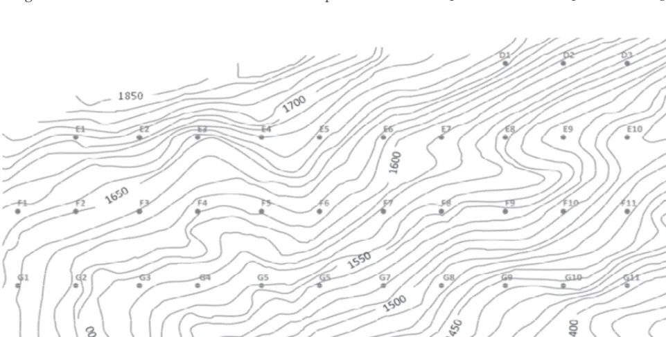
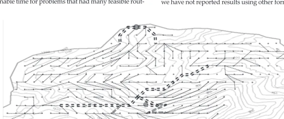
Fig. 1 Systematic nodes placed on the forest map
clearcut harvesting is used, the road network need not be permanent, and it need not be constructed at once. The network design problem then becomes a multi-period decision situation, which requires much larger models and is likely to be less »MIP-friendly« than the single period case.
The optimization problem is formulated, using an MIP model, to choose a least cost transportation net-work that supports all harvesting activities and the two transportation systems. Its objective is to mini-mize total cost of road construction, maintenance costs, transportation costs, and skidding costs.
2.1 Mathematical Model Definition – Definicija matematičkoga modela
To define the network design model, 298 nodes are placed in the center of each real harvesting area and located on the forest map (Fig. 1).
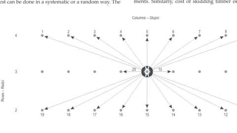
Each node has a known volume of timber cut that is to be extracted in each period. These real world data were already collected by forest inventory group. In this model, each node is defined with two arguments, i and j, indicating the horizontal axis, or columns, and the vertical axis, or rows, respectively (Fig. 2). Addi-tional nodes that are potential road intersections are then added. The distribution of the nodes over the for-est can be done in a systematic or a random way. The
examples presented in this paper are based on a sys-tematic placement of nodes on the forest map. Then, potential road segments are defined. For each node, a fixed number of arcs to near nodes are mapped, and their construction costs calculated using digital terrain data. Thus, all potential transportation decisions are based on directed arcs that connect nodes. Subject to terrain restrictions, each arc may be used as a skidding trail, or constructed to a road standard, or omitted from the solution altogether. In this work, there are potentially 20 adjacent nodes to each node, and hence as many as 20 outgoing and 20 incoming arcs at each node, creating a high density design network (Fig. 2). Finally, exit nodes are chosen, or added if necessary, to identify the connection(s) between the forest road sys-tem and the public highway syssys-tems.
The objective is to minimize the sum of road net-work, timber transportation, and skidding costs. Road network costs consist of road construction costs based on the segment length, terrain conditions, and road standard, as well as road maintenance costs which are calculated based on traffic volume over each segment, its length, and its characteristics. Transport costs along each road segment are based on its unit cost of trans-portation and volume transported. Unit costs vary ac-cording to the characteristics of individual road seg-ments. Similarly, cost of skidding timber on access
Fig. 2 Outgoing links at a systematic point
spurs is based on cost and hourly production of skid-ders, volume skidded and unit cost on each segment. The objective function is to minimize total costs:
min ( )
(i,j)
BCij B TC TV SC SV MC TV
roads∑ ij arcs ij ij ij ij ij ij
× + × + × + ×
((i,j)
∑ (1)
Where:
roads(i,j) means the set of all undirected segments connecting node i and node j,
arcs(i,j) means the set of all directed segments connecting node i to node j.
Coefficients and constants:
V Total volume of timber cut in the forest, C Capacity of a skidding spur,
Dn Volume to be left at demand exit node n
(equals zero if n is not an exit node), Voln Amount of timber generated in node n,
SCij Unit cost of skidding on arc (i,j),
TCij Unit cost of trucking on road (i,j),
BCij Capital cost to construct road (i,j),
MCij Unit cost of maintenance for road (i,j).
Binary Decision Variables:
Bij Equals 1 if the segment connecting nodes
i and j is built as a road, 0 otherwise,
Sij Equals 1 if timber is skidded on an access
spur between node i and node j, 0 other-wise.
Continuous decision variables:
SVij Volume of cut carried on arc ij through access spur k (skidded volume),
TVij Volume of cut carried by trucking on arc
(i,j).
Network Flow Variables:
SVIn Volume skidded into node n from
adja-cent nodes,
SVOn Volume skidded out of node n to adjacent
nodes,
TVIn Volume trucked into node n from
adja-cent nodes,
TVOn Volume trucked out of node n to adjacent
nodes,
SVLeftn Timber volume skidded into node n that is
left to be trucked on roads exiting node n. Constraints:
Rij+Sij ≤ ∀1, undirected arcs( , )i j (2)
Constraint 2 means that a link can be unused, a road, or an access spur. It cannot be used for both skid-ding and trucking.
TVij+TVij ≤V B× ij,∀undirected arcs( , )i j (3) Constraint 3 links the binary variable Bij to TVij and
TVji, so that if any trucking is carried out on road (i,j),
then Bij must be equal one.
SVij ≤ ×C Sij, ,∀i j (4) Constraint 4 links the binary variable Sij to SVij so that if SVij is > 0, then Sij must be equal to 1.
SVIn =
∑
×SVjn(j,n) in arcs (5)
SVOn =
∑
×SVnj(n,j) in arcs
(6)
TVIn =
∑
×TVjn (j,n) in arcs(7)
TVOn =
∑
×TVnj (n,j) in arcs(8)
Constraints 5, 6, 7, and 8 simply calculate volumes skidded and trucked in and out of each node.
SVIn + TVIn + Voln = SVOn + TVOn + Dn (9)
Constraint 9 is the standard flow conservation equation. Volume entering a node plus timber volume generated at a node must equal the volume leaving plus any demand volume left.
Dn= 0∀ interior nodes n (10)
Dn must be equal to zero if n is an interior node in
the network, but may be positive if n is an exit node.
SVIn+ Voln = SVOn + SVLeftn ∀ interior nodes n (11)
TVIn+ SVLeftn = TVOn ∀ interior nodes n (12)
Constraints 11 and 12 maintain the integrity of tim-ber product transportation by the different systems. Timber can be skidded from one arc to the next, but timber cannot be carried on a road link, off-loaded, and then skidded along the next link.
De V e
{ }
∑
= , where {e} is the set of all exit nodes(13) Equation 13 ensures that all timber from harvesting sites is transported to exit nodes.provide improved bounds and performance in the branching used by the mixed integer solver (Guignard et al. 1998).
First, constraints are added to trigger construction of an existing road segment if there is volume skidded to the node and left for trucking.
SVLeftn ≤
∑
V B× ni n i (n,i),( , ) means all undirected
arcs that are incident on node n. (14) Second, if there is volume to be harvested and transported at a node, then at least one skid spur or road that is incident to it must be built.
( ni ni) , (n,i)
B +S ≥ ∀n V >
∑
1 with n 0 (15) Third, no isolated road segments should be built.Bij ≤
∑
Bjk +∑
Bin (j,k) (i,n), when i and j are interior
nodes (16)
2.2 Study area and scenarios – Područje istraživanja i scenariji
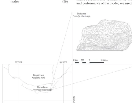
To examine the model performance, it was used in designing a forest road network in a mountainous area in Iran. The area is located between 53° 16 ′ 57″ E to 53° 21′ 35″ and 36° 12′ 11″ N to 36° 15′ 40″ N (Fig. 3). The 1 428 hectare mountainous hardwood forest is managed under sustainable forest management. The harvesting method is single tree selection with a con-tinuous return cycle of 10 years. Forest roads and their related skid trails are permanent. The potential net-work design was constructed by requiring one road link for every 2.27 hectares and one access spur for every 1.14 hectares.
Fig. 4 and 5 show an exploded view of a portion of the region with its feasible road links and feasible access spurs. In all, the model contains 252 harvesting sites, 883 potential spurs, and 440 road segments. One exit node is located at the top centre of the forest. The result-ing MIP model has 69 420 constraints, 33 085 variables, and 300 083 non-zero coefficients. To check the validity and performance of the model, we used the same
spa-Fig. 3 Study area
Fig. 4 Typical road feasibility; due to slope, swampy areas, or no volume to be extracted, there are typically less than 20 links for each node
Slika 4. Izvedivost šumske ceste. Zbog nagiba terena, močvarnih
područja ili gospodarske neisplativosti svaka mjerna točka obično ima manje od 20 veza s ostalim mjernim točkama
Fig. 5 Access spur feasibility; there may not be 20 links for each node because of steep terrain, swamp areas, or no volume at the systematically placed harvest node
Slika 5. Izvedivost traktorskoga puta. Moguće da će zbog nagiba
terena, močvarnih područja ili gospodarske neisplativosti biti manje od 20 veza među mjernim točakama
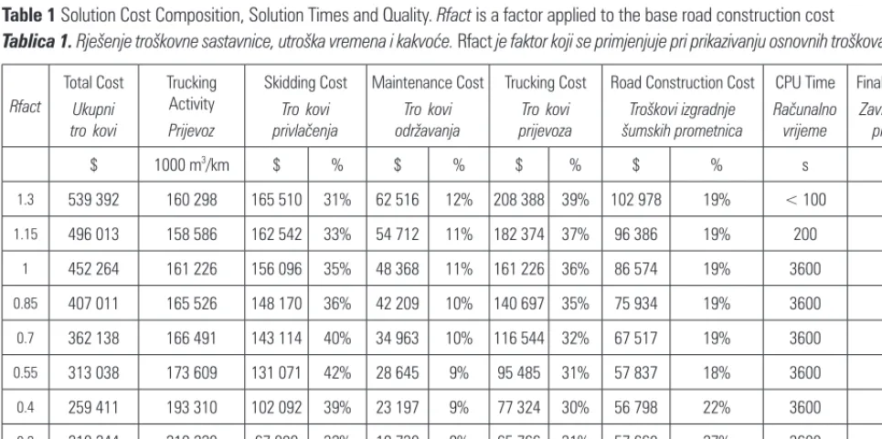
Table 1 Solution Cost Composition, Solution Times and Quality. Rfact is a factor applied to the base road construction cost
Tablica 1. Rješenje troškovne sastavnice, utroška vremena i kakvoće. Rfact je faktor koji se primjenjuje pri prikazivanju osnovnih troškova izgradnje
Rfact
Total Cost
Ukupni
troškovi
Trucking Activity
Prijevoz
Skidding Cost
Troškovi
privlačenja
Maintenance Cost
Troškovi
održavanja
Trucking Cost
Troškovi
prijevoza
Road Construction Cost
Troškovi izgradnje šumskih prometnica
CPU Time
Računalno
vrijeme
Final MIP Gap
Završna MIP praznina
$ 1000 m3/km $ % $ % $ % $ % s %
1.3 539 392 160 298 165 510 31% 62 516 12% 208 388 39% 102 978 19% < 100 < 1
1.15 496 013 158 586 162 542 33% 54 712 11% 182 374 37% 96 386 19% 200 < 1
1 452 264 161 226 156 096 35% 48 368 11% 161 226 36% 86 574 19% 3600 1.67
0.85 407 011 165 526 148 170 36% 42 209 10% 140 697 35% 75 934 19% 3600 3.87
0.7 362 138 166 491 143 114 40% 34 963 10% 116 544 32% 67 517 19% 3600 6.52
0.55 313 038 173 609 131 071 42% 28 645 9% 95 485 31% 57 837 18% 3600 10.06
0.4 259 411 193 310 102 092 39% 23 197 9% 77 324 30% 56 798 22% 3600 15.99
0.3 210 244 219 220 67 080 32% 19 730 9% 65 766 31% 57 668 27% 3600 12.63
0.2 162 371 235 438 57 118 35% 14 126 9% 47 088 29% 44 039 27% 3600 15.83
tial configuration and skidding costs, but varied road construction costs by factors 1.3, 1.15, …, to 0.40.
The values, assigned to skidding and road con-struction costs in the original scenarios, were 500$ and 18 400$, respectively. Then, to further test computa-tional performance, we generated a number of ran-dom instances of the problem by using Monte Carlo sampling to assign skidding and road construction costs. Probability distributions were fit to the original skidding and cost data, which were then sampled to create the random instances. The skidding cost distri-bution fit best to a three-parameter Beta, with mini-mum 4.00, size parameter 0.839, and shape parameter 2.81. Road construction costs were sampled from the uniform distribution on [2700, 14400]. In these random instances, all potential road segments and skid trails were assumed to be feasible. The resultant models have 9 520 skidding, 9 520 trucking, and 5 340 road construction feasible decision variables. These consti-tute a much denser network of potential arcs for both transportation systems.
Finally, seven of the original scenarios were modi-fied to add a second exit point at the bottom of the landscape.
The MIP models were created using OPL Studio 4.2 and solved using CPLEX version 10.0, both products of Ilog, Inc. They were solved using a Pentium 4 3.4 GHz CPU computer with 4 GB RAM, running Windows XP Professional. All models were run until the MIP gap was less than or equal to one percent, or one hour of CPU time was consumed, whichever occurred first.
3. Computational results –
Računalni
rezultati
Table 1 shows solution values, their cost composi-tion, solution times and final MIP gap for each of ten base scenarios. The scenarios were achieved by vary-ing the costs of road construction by a multiple called Rfact. Optimality gaps ranged from less than one per-cent to 16 perper-cent, and solution times ranged from less than 100 seconds to the cutoff point of 3 600 sec-onds. Solution quality, as measured by the final MIP gap, worsened as the road construction and trucking costs were reduced to 2 times the first case, then when Rfact was further reduced to 0.1. As expected, increas-ing road costs causes a correspondincreas-ing decrease in construction and use of hauling roads, with more tim-ber gathered through access spurs. Total trucking ac-tivity, as measured in volume-distance units, ranged from 160 298 to 251 818 m3/km. Fig. 6, 7, and 8 show
road network solutions achieved for three of the 10
Table 2 MIP Optimality Gap (%) for 10 randomly generated in-stances, with varied road construction costs. Model execution was terminated in one hour
Tablica 2. Optimalna MIP praznina (%) za deset nasumično oda
-branih slučajeva s različitim troškovima gradnje šumskih cesta. Vri
-jeme računanja modela iznosilo je sat vremena
Road Cost Change Factor
Različiti troškovi gradnje šumskih cesta
Case – Slučaj 0.4 0.55 0.7 0.85 1 1.15 1.3
1 16.3 10.1 3.76 < 1 < 1 < 1 < 1
2 13.45 8.89 2.53 < 1 < 1 < 1 < 1
3 15.05 10.25 5.12 < 1 < 1 < 1 < 1
4 16.4 10.93 4.55 < 1 < 1 < 1 < 1
5 15.33 9.21 4.11 < 1 < 1 < 1 < 1
6 15.9 8.6 2.73 < 1 < 1 < 1 < 1
7 17.69 15.09 7.63 < 1 < 1 < 1 < 1
8 16.06 10.7 10.63 5.2 < 1 < 1 < 1
9 14.88 9.27 2.17 < 1 < 1 < 1 < 1
10 17.43 10.8 3.57 < 1 < 1 < 1 < 1
Mean
Aritmetička sredina 15.849 10.384 4.68 1.42 < 1 < 1 < 1
Minimum
Minimum 13.45 8.6 2.17 < 1 < 1 < 1 < 1
Maximum
Maksimum 17.69 15.09 10.63 5.2 < 1 < 1 < 1
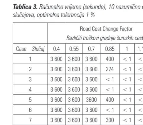
Table 3 CPU time (seconds), 10 random cases, optimality tolerance 1%
Tablica 3. Računalno vrijeme (sekunde), 10 nasumično odabranih
slučajeva, optimalna tolerancija 1 %
Road Cost Change Factor
Različiti troškovi gradnje šumskih cesta
Case – Slučaj 0.4 0.55 0.7 0.85 1 1.15 1.3
1 3 600 3 600 3 600 400 < 1 < 1 < 1
2 3 600 3 600 3 600 274 < 1 < 1 < 1
3 3 600 3 600 3 600 < 1 < 1 < 1 < 1
4 3 600 3 600 3 600 < 1 < 1 < 1 < 1
5 3 600 3 600 3600 400 < 1 < 1 < 1
6 3 600 3 600 3 600 < 1 < 1 < 1 < 1
7 3 600 3 600 3 600 300 < 1 < 1 < 1
8 3 600 3 600 3 600 3 600 < 1 < 1 < 1
9 3 600 3 600 3 600 < 1 < 1 < 1 < 1
Fig. 6 Solution showing the road and related access spurs (Rfact = 1.3)
Slika 6. Planirana šumska cesta s pripadajućim traktorskim putovima (Rfact = 1,3)
Fig. 7 Solution showing the road and related access spurs (Rfact = 1.0)
Slika 7. Planirana šumska cesta s pripadajućim traktorskim putovima (Rfact = 1,0)
scenarios. Dark lines indicate road segments, and lighter lines indicate the skidding paths. One can see that the solutions are feasible with respect to continu-ity of transport system and connection to the exit point.
Table 2 shows MIP gaps for the ten randomly gen-erated cases. Again, as the relative cost of roads de-creased, solution quality degraded. Gaps ranged from less than one percent to 17.69 percent. Table 3 shows CPU times for these 10 random cases with Rfact values ranging from 1.3 to 0.4. CPU times ranged from less than one minute to the cutoff point of one hour.
Fig. 9 Solution showing the road and related access spurs (Rfact = 1.00, 2 Exit Points)
Slika 9. Planirana šumska cesta s pripadajućim traktorskim putovima (Rfact = 1,00 s dvije izlazne točke)
Fig. 8 Solution showing the road and related access spurs (Rfact = 0.70)
Slika 8. Planirana šumska cesta s pripadajućim traktorskim putovima (Rfact = 0,70)
4. Discussion – Rasprava
The model produces valid results for the hierarchi-cal transportation model, with integrity of transport system and road system maintained. Moreover, the results are of very reasonable quality when compared to known upper bounds on optimality.
We have used the MIP gap to assess the quality of the solutions achieved. This is the percentage gap be-tween the best integer solution achieved and the best bound on the optimal solution found by the solver.
This does not mean that a solution with MIP gap of 15% is fifteen percent worse than the optimal solution. Rather, the measure guarantees that it is at least as good as 85% of the optimal.
The quality of solutions attainable in one hour CPU time varied with the cost structure of the problem in-stance. That is, when road costs were reduced relative to skidding costs, more CPU time was consumed to achieve solutions of the same quality as for instances with a higher road to skidding cost ratio. This behav-ior was observed in the original scenarios and in the randomly generated cases.
One of our research objectives was to determine whether it was possible to solve the MIP model in rea-sonable time for problems that had many feasible
rout-ing choices. We allowed 20 incomrout-ing and outgorout-ing arcs at each node of the network. Our first examples were constructed assuming a mountainous terrain, with many node-to-node connections infeasible due to slopes. However, for the ten randomly generated cases, all of these arcs were feasible. These models were solved to approximately the same quality of solution in much the same computational time as the original ten sce-narios. This indicates that density of the network is not a limiting factor in attaining a solution. Also, although we have not reported results using other formulations,
Table 4 Road network solutions with 2 exit points; solution cost composition, times and quality; Rfact is a factor applied to the base road construction cost
Tablica 4. Planiranje mreže šumskih prometnica s dvije izlazne točke. Rješenje troškovne sastavnice, utroška vremena i kakvoće. Rfact je
faktor koji se primjenjuje pri prikazivanju osnovnih troškova izgradnje
Rfact
Total Cost
Ukupni
troškovi
Trucking Activity
Prijevoz
Skidding Cost
Troškovi privlačenja
Maintenance Cost
Troškovi održavanja
Trucking Cost
Troškovi prijevoza
Road Construction Cost
Troškovi izgradnje šumskih prometnica
CPU Time
Računalno
vrijeme
Final MIP Gap
Završna MIP praznina
$ 1000 m3/km $ % $ % $ % $ % Sec. %
1.30 321 285 48 590 169 917 52.89 18 950 5.90 63 167 19.66 69 251 21.55 44 1.00
1.15 303 761 50 061 167 659 55.19 17 271 5.69 57 570 18.95 61 260 20.17 121 1.00
1.00 285 625 52 944 158 927 55.64 15 883 5.56 52 944 18.54 57 870 20.26 375 0.91
0.85 266 467 54 037 157 567 59.13 13 780 5.17 45 932 17.24 49 190 18.46 3 367 1.00
0.70 246 787 61 780 141 687 57.41 12 974 5.26 43 246 17.52 48 881 19.81 3 600 7.50
0.55 221 520 75 287 121 593 54.89 12 422 5.61 41 408 18.69 46 098 20.81 3 600 11.07
0.40 188 503 98 322 86 407 45.84 11 799 6.26 39 329 20.86 50 969 27.04 3 600 16.54
Fig. 10 Solution showing the road and related access spurs (Rfact = 0.40, 2 Exit Points)
we found that adding trigger constraints was important in improving MIP performance.
We can see from the network solutions (Fig. 8–10) that the solutions make sense spatially. However, one might question the potential for this model to produce long skidding routes that are feasible in practice. There are no direct constraints on skidding distances in the solution. Instead, arc capacity constraints were used to reduce the likelihood that timber would be skidded too far, by constraining the accumulated flow through each skidding trail. It should be noted that the capac-ity method works only approximately since timber volumes vary between stands and skidding volumes may accumulate to the imposed capacity over distanc-es which are not acceptable. This implidistanc-es that it might be necessary to subject the network to some post–op-timization fixing if excessive skidding distances occur.
5. Conclusion –
Zaključci
This model is designed to create access networks for areas to be continuously harvested by selection harvesting, and hence require a permanent road net-work. In such forests there are generally two choices of road standard, the skidding and the hauling road standards. The cost considerations are that the higher standard roads have higher construction costs but lower transportation costs. Moreover, once timber is skidded to a road location, it must be then transported over hauling roads until it reaches an exit point of the network. To minimize total cost, costs in both net-works should be considered simultaneously. This model solves this problem in reasonable computa-tional time and produces realistic solutions of reason-able quality. Solver performance was robust with re-spect to density of the input network, but sensitive to the cost structure. Solving models with two exit points was not appreciably more difficult than solving those with one exit, but the solutions attained were radi-cally different in structure and in cost.
The examples and the discussion have focused on skidding and hauling transportation systems. This model could also be used to design access systems where any two different transportation systems exist, to create a primary network from which the goods are transported to the secondary network. We did not test systems with more than two transportation systems standards, but the model is easily extended to accom-modate more transportation systems and road stan-dards.
The CPLEX, commercial MIP solver was able to solve these problems easily, attaining optimal solu-tions in less than one minute in most cases, and
attain-ing solutions with optimality bound less than 20% in all cases. Forecasting performance for branch and bound methods using a few instances is risky, since results can vary widely. We found that the cost struc-ture had a significant impact on performance, while the network density did not.
In conclusion, we have presented a model and study to show a mixed integer programming method to design an access network for hierarchically con-strained transport systems. The system can minimize costs of construction, transportation, and maintenance for a dense network of potential arcs, and can solve the problem in reasonable time. These results are quite positive, and it is important for decision makers to realize that models of this size, which would have been considered intractable a short time ago, can be solved in a reasonable time, and can provide useful decision support.
6. References – Literatura
Anderson, E. A., Nelson, J., 2004: Projecting vector-based road networks with a shortest path algorithm. Can J For. Res. 34(7): 1444–1457.
Chung, W., Session, J., 2001: NETWORK 2001 – Transporta -tion Planning Under Multiple Objectives; The Interna-tional Mountain Logging and 11th Pacific Northwest Skyline Sym
-posium.
Clark, M. M., Meller, R. D., McDonald, T. M., 2000: A Three-Stage Heuristic for Harvest Scheduling with Access Road Network Development. For. Sci. 46(2): 204–218.
Crowe, K., Nelson, J., Boyland, M., 2003: Solving the area-re -stricted harvest-scheduling model using the branch and bound algorithm. Can. J. For. Res. 33(9): 1804–1814.
Falcao, A.O., Borges, J. G., 2001: Designing an Evolution Pro -gram for Solving Integer Forest Management Scheduling Models: An Application in Portugal. For. Sci. 47(2): 158–168. Goycoolea, M., Murray, A. T., Barahona, F., Epstien, R., Win -traub, A., 2005: Harvest Scheduling Subject to Maximum Area Restrictions: Exploring Exact Approaches. Ope. Res. 53(3): 490–500.
Guignard, M., Ryu, C., Spieldberg, K., 1998: Model tightening for integrated timber harvest and transportation planning. Eur. J. Ope. Res. 111(3): 448–460.
Guignard, M., Yan, H., 1993: Structural decomposition meth -ods for dynamic multiple machine, multiple hydropower plant optimization. Dec. Sci. Rep. 111: 448–460.
Gunn, E. A., Richards, E. W., 2005: Solving the adjacency prob -lem with stand-centred constraints. Can. J. For. Res. 35(4): 832–842.
Jones, J. G., Hyde, J. F. C., Meacham, M. L., 1986: Four ana -lytical approaches for integrating land management and transportation planning on forest lands. Res. Pap. INT-36l, USDA Forest Service, Intermountain Res. Sta. 32 p.
Kirby, M., Hager, W., Wong, P., 1986: Simultaneous planning of wildland management and transportation alternatives. TIMS Studies in the Management Sciences 21: 371–387. Lu, F., Eriksson, L. O., 2000: Formation of harvest units with genetic algorithms. For. Eco. Man. 130(1–3): 57–67.
Najafi, A., Sobhani, H., Saeed, A., Makhdom, M., Mohajer, M. M., 2008: Planning and Assessment of Alternative Forest Road and Skidding Networks. Cro. J. For. Eng. 29(1): 63–73.
Newnham, R. M. 1995: Roadplan: A tool for designing forest road network. Int. J. for Eng. 6(2):17–26.
Richards, E. W., Gunn, E. A. 2003: Tabu Search Design for Difficult Forest Management Optimization Problems. Can. J. For. Res. 33(6): 1126–1133.
Weintraub, A., Jones, J. G., Meacham, M. L., Magendzo, A., Malchuk, D., 1995: Heuristic procedures for solving mixed-integer harvest scheduling-transportation planning models. Can. J. For. Res. 25(10): 1618–1626.
Sažetak
Planiranje mreže primarnih šumskih prometnica primjenom modela
mješovitoga cjelobrojnoga programiranja
Troškovi su izgradnje i održavanja šumskih prometnica veliki te je zbog toga važno razviti metode projektiranja šumskih prometnica koje u obzir uzimaju minimalan utrošak novčanih sredstava.
Ovaj je članak optimizirani model mješovitoga cjelobrojnoga programiranja (MIP) koji služi za planiranje mreže šumskih prometnica uzimajući u obzir minimalan utrošak novčanih sredstava pri izgradnji i prijevozu drvnih sor -timenata.
Problem pri optimizaciji, uz primjenu modela MIP, bio je odabrati najučinkovitiju mrežu šumskih prometnica koja omogućuje sve aktivnosti u pridobivanju drva. Cilj je spomenutoga modela smanjiti troškove gradnje i održavanja šumskih cesta te troškove primarnoga i sekundarnoga transporta drva.
Pri definiranju sustava za planiranje mreže šumskih prometnica odabrano je 298 smještenih točaka u prostoru. Za svaki točku poznat je drvni volumen za sječu i privlačenje. Kako bi se točke spojile (u buduću šumsku prometnicu), za svaku je sniman broj lukova (poveznica) prema susjednim točkama, a troškovi izgradnje šumske ceste izračunati su pomoću podataka iz digitalnoga modela terena.
Dakle, planiranje je mreže šumskih prometnica temeljeno na smjeru pružanja lukova koji povezuju mjerne točke. U skladu s terenskim ograničenjima svaki luk (buduća prometnica) može služiti kao primarna ili sekundarna šumska prometnica ili se potpuno izostavlja iz modela.
O ovom radu svaka mjerna točka ima 20 mogućih susjednih točaka, a samim time i 20 odlaznih i 20 dolaznih lukova stvarajući na taj način vrlo gustu mrežu šumskih prometnica. Cilj je minimizirati gustoću mreže šumskih prometnica te troškove primarnoga i sekundarnoga transporta drva.
Primjenjivost modela ispitivana je pri planiranju mreže šumskih prometnica u planinskom području u Iranu. Šumske su ceste i njihovi pripadajući traktorski putovi trajne građevine. U model su ugrađena ukupno 252 radilišta (mjesta sječe), s 883 potencijalna traktorska puta i 440 segmenata šumskih cesta. Izlazna je točka iz sastojine smještena na gornjem dijelu istraživanoga područja. U konačnici model MIP sadrži 69 420 terenskih ograničenja, 33 085 varijabli i 300 083 koeficijenta koji svi zajedno određuju mrežu šumskih prometnica. Pri provjeravanju valjanosti i učinkovitosti modela korišteni su isti prostorni podaci i troškovi transporta uz različite faktore za izračun troškova gradnje (u rasponu 1,3; 1,15,..., do 0,40). Dobiveno je sedam mogućih modela (scenarija) mreže šumskih promentica te je dodana i druga izlazna točka pri dnu istraživanoga područja. Kao što se i očekivalo, povećanjem novčanih sred -stava utrošenih u izgradnju šumskih cesta smanjuju se novčana sredstva za izgradnju traktorskih putova te se zbog toga na njima povećava drvni volumen u primarnom transportu. Ukupni transport drvnoga volumena istraživanoga područja kretao se u rasponu od 160 298 do 251 818 m3/km. Ukupni su troškovi značajno smanjeni u usporedbi s
-otna razlika između najbolje dostignutoga cjelobrojnoga rješenja i najbolje veze s optimalnim rješenjem pronađene putem rješavača (tzv. solver). U svim slučajevima model MIP u mogućnosti je proizvesti dobro rješenje problema u vrlo razumnom računalnom vremenu. Jedan od ciljeva ovoga istraživanja bio je odrediti je li moguće pronaći rješenje problema vezanih uz planiranje trasa modelom MIP u razumnom računalnom vremenu. Stoga su prvi primjeri bili rađeni za planinski teren, s mnogo neostvarivih veza među mjernim točkama zbog ograničavajućega nagiba. Sustav može minimizirati troškove izgradnje, transporta i održavanja kod guste mreže prometnica s mnogo mogućih lukova povezivanja i riješiti problem u razumnom vremenu, što ga čini prikladnim sustavom za potporu odlučivanja u šumarstvu. Ovaj model može biti primijenjen pri planiranju pristupnih pravaca, gdje postoje dva različita trans -portna sustava, za planiranje sekundarne mreže s kojih se dobra (drvo) transportira na primarnu mrežu šumskih prometnica. Model nije testiran na više od dva različita transportna sustava, ali se vrlo lako može proširiti na druge transportne sustave i prometne standarde. Struktura je troškova važan čimbenik na učinkovitost modela, dok gustoća mreže šumske prometne infrastrukture nije.
Ključne riječi: optimizacija, troškovi pridobivanja drva, gustoća mreže šumskih prometnica, trakorski putovi, planiranje pristupa šumi
Received (Primljeno): September 17, 2011 Accepted (Prihvaćeno): December 13, 2011
Authors’ address – Adresa autorâ: Assist. Prof. Akbar Najafi, PhD. * e-mail: [email protected] Tarbiat Modares University Faculty of Natural Resources Department of Forestry
Imam Ave, Noor, Mazandaran Province P.O. Box 64414–356
IRAN
Assoc. Prof. Evelyn W Richards, PhD. e-mail: [email protected]
University of New Brunswick Faculty of Forestry and Environmental Management Forestry/Geology, Rm. 201 UNB Fredericton Campus CANADA