Platys: An Active Learning Framework for
Place-Aware Application Development and Its
Evaluation
Pradeep K. Murukannaiah
Munindar P. Singh
Abstract
We introduce a high-level abstraction of location calledplace. A place is not nec-essarily centered on physical space, and derives its meaning from a user’s activities and social context. In this manner, place can facilitate improved user experience compared to traditional representation of location, which is spatial coordinates. We propose
Platysframework as a way to address the special challenges of place-aware applica-tion development. The crux of Platys is a middleware that 1. learns a model of places specific to each user viaactive learning, a machine learning paradigm, to reduce the user-effort required for training the middleware, and 2. exposes the learned user-spe-cific model of places to applications at run time, insulating application developers from dealing with low-level sensors and nuances in how users perceive places.
We evaluated Platys via two studies. First, we applied Platys’ active learning ap-proach to learn a model of places for each of 10 users from the user’s place labels and sensor data collected from an Android phone. Compared with two supervised and two unsupervised place learning approaches, we found that Platys 1. requires fewer place labels than traditional supervised approaches to learn a user’s places with desired ac-curacy, and 2. learns places with higher accuracy than unsupervised approaches.
Second, we conducted a developer study to evaluate Platys’ efficiency in assist-ing developers and its effectiveness in enablassist-ing usable applications. In this study, 46 developers employed Platys or the Android location API to develop a place-aware application. Our results indicate that application developers employing Platys, when compared to those employing the Android API, 1. develop a location-aware applica-tion faster and perceive reduced difficulty and 2. produce applicaapplica-tions that are easier to understand (for developers) and potentially more usable and privacy preserving (for application users).
1
Introduction
is location-aware. As Weiser [1999] observed, “the most profound technologies are those that disappear.”
Weiser’s vision leads to three major questions that we seek to address in this paper.
1. What are the levels of abstraction (or granularity) at which a mobile application could employ the location information?
2. What are the implications of the chosen level of abstraction on the process of location-aware application development?
3. How does the chosen level of location abstraction affect the quality of the applications produced both from the perspectives of application developers and end-users?
In current practice, most location-aware applications represent location asposition, i.e., spatial coordinates (usually latitude and longitude). We imagine that position is popular because it matches existing location acquisition techniques including Global Positioning System (GPS), and cellular and WiFi triangulation Küpper [2005]. Current mobile devices provide hardware (built-in sensors) and software (programming interfaces to the sensors) support for position acquisition. Thus, developing a position-aware application is natural for an application developer.
1.1
From Position to Place
Applications employ location in some typical ways:
1. Explicit. Using the information as is, as below:
• Informative.An application can provide a user’s location information explicitly, e.g., it may display the location in a calendar or tag location on a photo.
• Social disclosure. An application can disclose a user’s location to the social contacts of the user, e.g., on a social network site or in a text message.
• Commercial disclosure. An application can disclose a user’s location to a third party for a commercial purpose, e.g., to obtain a coupon for a nearby coffee shop.
2. Implicit. An application can automate a task based on the user’s location. For example, consider a personalization task such as changing the ringer mode of the phone or for-warding text messages to email, which can be performed automatically depending upon where the user is.
Whether an application employs location for the user to benefit from the location per-sonally (for information or task execution), or exploits location to share it with others (for social or commercial purpose), what is a desirable level of abstraction at which to do so? We doubt it would be position; spatial coordinates do not have an inherent meaning for the user. Instead, we imagine that a notion such as home, office, restaurant, andpark is more natural. We term this level of location abstractionplace. Employing place instead of position has three implications on location-aware applications.
• By presenting location in a way that is natural to users, place can enhanceusability, i.e., the ease with which a user can exercise an application Ryan and Gonsalves [2005].
• Place opens up new avenues for intelligent location-aware applications including social networks Murukannaiah and Singh [2012], personal assistants desJardins et al. [2005], pervasive and social games Magerkurth et al. [2005], recommender systems Wang et al. [2012], and virtual worlds Hendaoui et al. [2008].
• Place can enhance location privacy Duckham and Kulik [2006] by providing users an easier means for controlling the extent to which their location information is shared, e.g., by sharing the information that a user is in a class instead of sharing the physical location of the specific class.
1.2
Place-Aware Application Development
Although place offers potential benefits as a location abstraction, place-aware application development is quite challenging.
First, how can a place-aware application represent and reason about the places that a user may care for? In general, developers cannot determine the needs of each potential user. For example, a model yielding home, office, andelsewhere might suffice for a user, but another user might want a model that distinguishes multiple offices. Additionally, a user’s location needs often change over time.
Second, each developer may employ a distinct place model imposing an unnecessary burden the user. For example, an application may model aclassto include regular lectures and guest lectures whereas another application may differentiate the two events as taking place in alecture hall and aseminar hall, respectively.
Third, we need to provide architectural support for developing a place-aware applica-tion including means for modeling and acquiring place informaapplica-tion.
1.3
Contributions and Organization
describing the middleware, we synthesize a conceptualmetamodelbased on various place-related constructs (Section 2). Second, we describe Platys Reasoner, a key component of the middleware, which reasons about places from sensor data (Section 4). Platys Rea-soner is novel in that it 1. reasons about a user’s places subjectively, enhancing the user experience delivered by place-aware applications, 2. prompts the user to label places only if required, reducing the user effort involved in training the reasoner, and 3. makes realistic assumptions that sensors readings for place recognition will be from multiple sources and intermittent.
We evaluate Platys via two studies involving real users.
1. A user study finds that Platys Reasoner is effective for place recognition, reducing user effort and enhancing place recognition accuracy (Section 5).
2. A developer study finds that Platys framework is effective for place-aware application development, reducing development time and effort, and potentially enhancing the us-ability of location-aware applications (Section 6).
We summarize the related work in Section 7, identify some directions for future re-search in Section 8, and conclude in Section 9.
2
A Conceptual Metamodel of Place
The notion of place has been studied under constructs such as place attachment, place iden-tity, sense of place, and semantic location. Gieryn [2000] identifies geographic location, material form, and meaning and value as three features of a place. Scannell and Gifford [2010] describe the meaning of a place using a tripartite model involving people (individu-als or groups), place characteristics (social or physical), and processes (behavior, cognition, or affect). The interactionist theory of place attachment suggests that the meaning given by an individual to a physical site comprises the individual’s memories of interactions as-sociated with that site (interactional past) as well as future experiences perceived as likely (interactional future) Goel et al. [2011], Kyle and Chick [2007], Milligan [1998]. Harrison and Dourish [1996] distinguish space and place by a phrase that “we are located in space, but we act in place.”
We synthesize (as Lewicka [2011] advocates) various place-related constructs as an informational entity that can be computed and employed in mobile applications. Figure 1 shows our conceptual metamodel, which can be used to model each place of interest to a user via its relationships with one or more of the following entities.
interacts with Place
Social Circle Activity
Position Action ContactSocial
Space
Environment
Mobile
Device User
maps to occurs at gathers at
observed at senses
performs
senses carries
Figure 1: A conceptual metamodel relating place to space, activities, and social circles.
• Activity. A place derives its meaning from the activities that occur there. For example, a user’shome might be a place of entertainment, rest, and eating, whereas aresearch lab
might be associated with activities such as writing a paper. Thus, a set of activities can be used to specify a place of interest to a user.
• Social circle. The places of interest to a user are often occupied by his or her social contacts. The user is likely to perceive a logical group of such contacts as a social circle Murukannaiah and Singh [2012]. For example,home is occupied by family members,
workplace by colleagues, and classrooms by classmates. Thus, a place can also be described by the social circle associated with it.
We make three assumptions about modeling of places.
1. A place can be completely specified by any combination of space, activity, and social circles. This assumption opens up interesting possibilities for spatially overlapping, dispersed, and space-less places. For example, twoclassrooms in different corners of a college campus can be the same place specified by the unique set of activities that take place in a classroom; the samecoffee shop may be two different places—acaffeine fix
and ameeting place—differentiated by the social circles involved; an Internetchat room
might have no spatial aspects, but can be specified via activities or social circles.
2. A places is ego-centric, e.g.,workplace of a physician and that of a software engineer can each be modeled as comprising different sets of activities.
device. Activities and social circles can be computed from observable actions and in-teractions of a user. Examples of observable actions include URLs visited, applications used, and physical movement, and that of observable interactions include emails, text messages, and phone calls.
The notion of context is related to place. In contrast to context, which is defined as “any relevant information” Dey et al. [2001], we base place on three contextual attributes: space, user activities, and social circles. In doing so, we make explicit what is that we seek to compute (recognize) and the corresponding assumptions. This helps 1. developers determine if Platys provides the abstractions they desire, and 2. end-users train Platys ap-propriately (we imagine that asking a user about his or her space, activities, or social circles is clearer than asking about context).
3
Platys: Framework for Place-Aware Application
Devel-opment
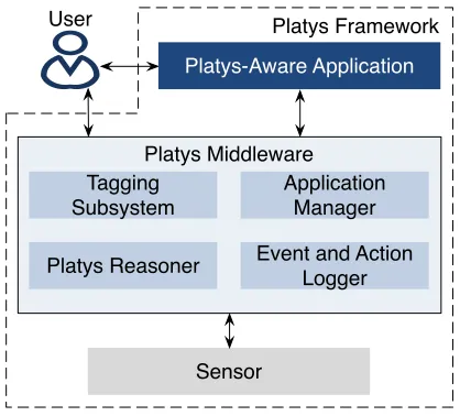
As shown in Figure 2, Platys framework consists of sensors, a middleware, and applica-tions. The middleware is its key component. In a nutshell, 1. a user interacts with the middleware and trains it about places of interest, 2. the middleware learns to recognize places of interest to each user from low-level sensor data, and 3. multiple applications in-teract with the middleware to know the user’s places.
Platys Framework
Platys Middleware
Sensor User
Platys Reasoner Tagging Subsystem
Application Manager Platys-Aware Application
Event and Action Logger
3.1
Platys Middleware
Let us consider the benefits of a middleware. We hypothesize that developing location-aware application employing a high-level abstraction such as place can be time-consuming. Thus, providing an off-the-shelf component that simplifies place-aware application devel-opment can be valuable. However, networking, coordination, delegation, and heterogeneity Emmerich [2000], Issarny et al. [2007] are inevitable requirements for building such a com-ponent because 1. data for reasoning about a user’s places come from sensors on multiple devices, e.g., smart phone, tablets, and an increasing variety of wearable devices, and 2. the sensors, place reasoner, and place-aware applications may all reside on different hosts.
The Platys middleware is responsible for 1. efficiently gathering data from multiple low-level sensors; 2. computing high-level concepts such as places, activities, and social circles from low-level data specific to each user; and 3. exposing the learned high-level concepts to place-aware applications as per a user’s needs.
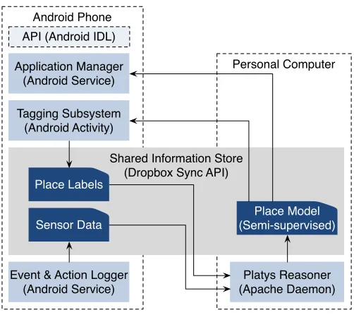
Figure 3 shows the architecture of the Platys middleware consisting of four subsystems. The figure also shows the platform for which we have implemented each components. Each subsystem may be potentially hosted on any of a user’s personal device. The subsystems communicate asynchronously via a shared information store.
Personal Computer Android Phone
Shared Information Store (Dropbox Sync API)
Place Labels
Sensor Data
Place Model (Semi-supervised)
Tagging Subsystem (Android Activity)
Event & Action Logger (Android Service) Application Manager
(Android Service)
Platys Reasoner (Apache Daemon) API (Android IDL)
Figure 3: Platys middleware’s subsystems. The subsystems are loosely coupled and com-municate asynchronously via a shared information store. Each of a user’s personal devices can host one or more of the subsystems.
email, SMS, and calendar. A user can control what sensors and data sources to use and at what frequency to collect the data.
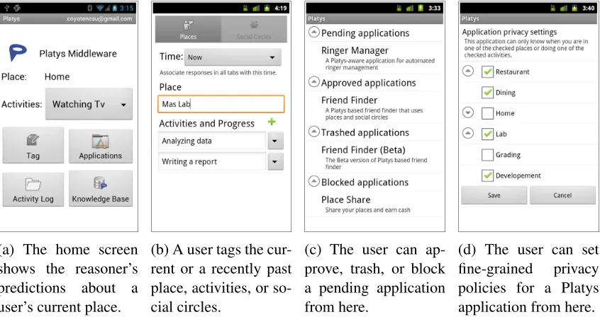
For Platys to make sense of the sensor data, the tagging subsystem helps a user train Platys on the relevant place, activity, and social circle. Since smart phones are always with a user, they are ideal to deliver notifications prompting the user to tag. Figure 4b shows the user interface from our Android implementation of the tagging subsystem. The user may ignore any prompt or delay responding.
The Platys reasoner builds a machine learning model to associate user tags with sensor data. In a typical scenario, the user tags places for a training period and the reasoner subsequently predicts the places, activities and social circles. Further, the reasoner assigns a confidence level to its predictions in order to enable active learning (Section 4). A resource-rich device such as a user’s personal computer (compared to a mobile device) is ideal for hosting the reasoner.
Platys-aware applications interact with the application manager to acquire a user’s places, activities, and social circles. The application manager respects privacy preferences specified by a user as shown in Figures 4c and 4d. An instance of the application manager must be hosted on each device which hosts place-aware applications.
(a) The home screen shows the reasoner’s predictions about a user’s current place.
(b) A user tags the cur-rent or a recently past place, activities, or so-cial circles.
(c) The user can ap-prove, trash, or block a pending application from here.
(d) The user can set fine-grained privacy policies for a Platys application from here.
Figure 4: Screenshots from the Platys middleware’s subsystems.
3.2
Platys-Aware Application Development
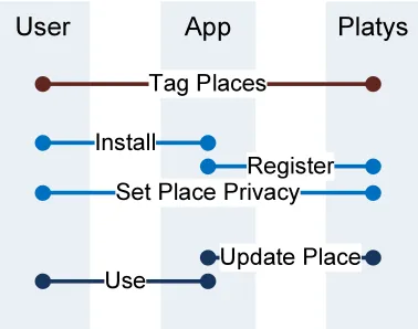
between application developers and users. With Platys, what users tag is what an appli-cation can see: A user trains the Platys middleware to recognize places of interest; the Platys middleware learns to recognize the tagged places and exposes them to applications. Thus, an application can rely on the Platys to provide places of interest to each of its users. Further, a user can tag new places and Platys automatically updates the places it exposes to the applications. Code snippets of how an application interacts with the middleware are shown in Appendix B.
Second, Platys exposes places uniformly across all applications. Since each Platys-aware application employs places exposed by Platys, the user avoids the burden of under-standing multiple place models.
Third, Platys provides users fine-grained control on privacy. In current practice, a user’s control on privacy is typically at the level of all locations or none. However, a user’s will-ingness to disclose location depends on who is requesting, why, and the details requested Smith et al. [2005]. Platys supports such fine-grained privacy policies.
Figure 5: Interactions between a user, a Platys-aware application, and the Platys middle-ware. The user tags places on an ongoing basis; the application is installed and registered; the middleware continually sends place updates to the application as needed.
4
Platys Reasoner
Now we describe how our middleware recognizes places of interest to a user. The Platys tagging subsystem collects place labels from an end-user and the event and action logger collects raw data from sensors. Then, the task of the Platys Reasoner is to recognize places (corresponding to a user’s labels) from raw sensor readings.
This task can be addressed via a traditional machine learning paradigm. Specifically,
staypoint-based approaches do not require labeling, they have the following shortcomings. One, staypoints do not capture subjective nuances in how users perceive places since: (a) no fixed values forradiusanddurationyield desired places for all users, and (b) staypoints ex-clude interesting possibilities in terms of spatially overlapping and dispersed places. Two, a staypoint does not carry an inherent meaning. A user may eventually need a symbolic name (hence labeling) to distinguish staypoints Lin et al. [2010]. Three, staypoint-based approaches, often, require frequent sensor readings to find patterns in the unlabeled data. For example, Ashbrook and Starner [2002] and Zhou et al. [2007] scan GPS every second and minute, respectively. However, sensing consumes battery power—a limited resource on mobile devices.
Alternatively,supervised learningtechniques exploit user-provided place labels. A tra-ditional classifier such as logistic regression or support vector machine (SVM) Hastie et al. [2001] can be learned from sensor data treating place labels as class labels. Typically, train-ing a classifier requires several traintrain-ing instances per class to produce good classification accuracy. However, acquiring training instances is challenging because place labeling re-quires user effort. Requiring each user to label each place of interest several times is not practically viable. Additionally, sensor readings are likely to be (a) intermittent (all sensor readings may not be available when a user labels a place, e.g., GPS reception is limited in-doors), and (b) infrequent (since sensing frequently can drain battery). Thus, many training instances constructed from sensor data are likely to be sparse (missing feature values).
The Platys Reasoner seeks to address the shortcomings of the above approaches. Specif-ically, it combines two machine learning paradigms: (1)active learning Settles [2012] to reduce the labeling effort, and (2)semi-supervised learningZhu et al. [2009] to efficiently deal with intermittent and infrequent sensor data. Next, we explain these paradigms and how Platys Reasoner employs them for place recognition. We provide a formal description of the problem and solution (with pseudocode) in Appendix A.
4.1
Intuition: Active and Semi-supervised Learning
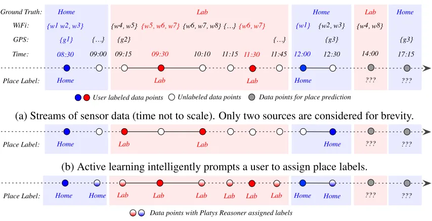
As an example, Alex is a Platys user. Figure 6a captures Alex’s routine on a typical day: Alex is athome in the morning, during lunch, and evening; he works from hislab during a morning session and an afternoon session. As shown, Alex has labeled the two places, twice each, and there are sporadic sensor readings throughout. For simplicity (and without loss of generality), we consider only two sources of sensor readings. LetG(t)and W(t), and P L(t), respectively be the GPS reading, WiFi scan result, and place label at time t. However, not all sensor readings may be available at each time; e.g., only WiFi scan result is available at 9:30 (GPS reception being poor indoors).
Now, we consider the questions: Given historical data (labels and sensor readings), and
W(14:00) ={w4, w8}, what is Alex’s place at 14:00? Similarly, given historical data and
G(17:15) ={g3}, what is his place at 17:15?
Home
09:30
Lab
09:00 11:30
Lab
11:15 12:00
Home
14:00
???
08:30 09:15 10:10 12:30 17:15
??? {w1 w2, w3} {w4, w5} {w5, w6, w7}{w6, w7, w8}{…}{w6, w7} {w1} {w2, w3} {w4, w8}
{g1} {…} {g2} {g3} {g3}
Time:
Place Label: WiFi: GPS:
Ground Truth: Home Lab Home Lab Home
User labeled data points Unlabeled data points Data points for place prediction 11:45
{…}
(a) Streams of sensor data (time not to scale). Only two sources are considered for brevity.
Home Lab Lab Home ??? ???
Place Label:
(b) Active learning intelligently prompts a user to assign place labels.
Home Lab Lab Home ??? ???
Place Label:
Data points with Platys Reasoner assigned labels
Lab Lab Home
Home Lab Lab
(c) Semi-supervised learning exploits place labels and latent structure in the unlabeled data.
Figure 6: An illustration of the place recognition problem and intuitions behind Platys Reasoner’s techniques: active and semi-supervised learning
given few and incomplete training instances. For example, a traditional classifier does not predict places any better than random guessing for Alex. The reason is that the instances to be predicted, i.e.,W(14:00) = {w4, w8}, andG(17:15) = {g3}have nothing in common
with the training instances.
The Platys Reasoner employs a classifier, albeit with additional steps in learning to address the challenges of traditional classification. Platys Reasoner’s additional steps are motivated by the following intuitions.
1. Can we employ fewer training instances than traditionally required to train a classifier to achieve a desired accuracy? Yes, if we control what those training instances are (same number, though). For example, givenP L(8:30) =homeandW(8:30) ={w1, w2, w3}, it is not useful to labelP L(12:00)ashome, whenW(12:30) ={w1}. Instead, it would
be better if we asked Alex to label at 12:30 as shown in Figure 6b. Then, we could cor-rectly predictP L(17:15)ashome, unlike a traditionally trained classifier which could only guess randomly with original labels.
2. Can we exploit both labeled and unlabeled instances for training to achieve a better classification accuracy than training with labeled instances alone? Yes, if we exploit the hidden structure in the unlabeled data. For example, given that P L(9:30) = lab
and W(9:30) = {w5, w6, w7}, we notice that W(9:15) = {w4, w5}and W(10:10) =
{w6, w7, w8} overlap with W(9:30). From this, we can assign P L(9:15) = lab and
4.2
Place Recognition Pipeline
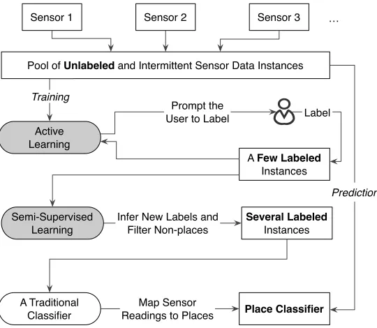
Platys Reasoner incorporates the above intuitions by employing active and semi-supervised learning techniques, as shown in Figure 7. The reasoner operates intrainingandprediction
modes. In the training mode, Platys starts from sporadic streams of sensor data. The active learner chooses a few instances from the pool of unlabeled data and asks a user to label them. The active learner chooses only from recently sensed data so that the user would remember what labels to use. The semi-supervised learning module picks up from where the active learner leaves off—with a few labeled instances and many unlabeled instances. The semi-supervised learner exploits the structure in unlabeled data and assigns place labels to several previously unlabeled instances. Finally, the reasoner trains a classifier from all labeled instances (user assigned and inferred). Once the place classifier is trained, given an unlabeled sensor reading, Platys Reasoner predicts the user’s place at the time of the reading.
Pool of Unlabeled and Intermittent Sensor Data Instances
Active Learning
Sensor 1 Sensor 2 Sensor 3 …
Prompt the User to Label
A Few Labeled Instances
Infer New Labels and Filter Non-places
Several Labeled Instances Training
Semi-Supervised Learning
A Traditional
Classifier Place Classifier
Label
Prediction
Map Sensor Readings to Places
Figure 7: Platys Reasoner learns a place classifier from unlabeled sensor data.
4.2.1 Active Learning
Given a pool of unlabeled instances (from recent past) and all labeled instances (histori-cal), our objective is to choose an instance which, if labeled, would be most beneficial in improving our classifier. Platys Reasoner adapts a technique calleduncertainty sampling
Settles [2012]:
2. Train a classifierfrom labeled instances alone.
3. Predict a place labelfor each unlabeled instance.
4. Find the classifier’s confidencefor each prediction.
5. Prompt the userto label the place for an instance predicted with least confidence.
Any classifier can be employed in the above as long as the confidence of predictions can be measured. We employ logistic regression and SVM in our analyses (Section 6). For logistic regression, the probability with which an instance is predicted as belonging to a class indicates the confidence. For SVM, thedecision value, i.e., the distance of the in-stance being predicted from the separating hyperplane of the trained model, is an indicator of confidence Vlachos [2004].
Active learning is a continual process. As long as there are unlabeled instances that the active learner is uncertain about, it asks the user to label them. The process is robust and uses whatever information it has—a user may ignore a labeling request or proactively label a place.
4.2.2 Semi-Supervised Learning
The objective of semi-supervised learning is to exploit unlabeled sensor readings, given a few readings with place labels. It is effective since sensor readings tend to form well-separated clusters Eagle and Pentland [2006]. We employ this intuition in a semi-supervised technique calledself trainingZhu et al. [2009]. Complementary to the active learner, which asks the user when in doubt, the semi-supervised learner teaches itself from its own confi-dent predictions. The technique operates as follows.
1. Train a classifierfrom sensor readings with user-assigned place labels.
2. Predict a place labelfor each unlabeled sensor reading via the above classifier.
3. Retrain a classifierfrom both original and newly inferred labels.
A potential problem is that the above approach assigns a place label to each sensor reading whereas some sensor readings may belong to none of the labeled places. Such readings correspond to uninteresting or novel places. Thus, we seek to filter such “noisy” sensor readings before training the final classifier. A simple strategy to filter out noisy sensor readings is to not assign a place label to an instance if the prediction confidence is below a threshold (in the second step above). However, how do we find an optimal threshold? Again, manually fixing a threshold across all places (similar to fixing staypoints’ radius or duration) is not desirable—characteristics of different places may vary. Instead, we eliminate noisy readings by iteratively clustering sensor readings as follows.
2. Eliminate a sensor readingfrom a place if the reading’s similarity to original instances is less than the mean similarity for the corresponding place.
3. Repeat the above stepsuntil the difference in the number of instances eliminated in two consecutive iterations is negligible.
The result of the above process is a tightly-knit clusters of sensor readings such that at least one instance in each cluster has a place label. Now, we assign the same label to all instances in a cluster and train the final place classifier.
4.3
Platys Social: Recognizing Ego-Centric Social Circles
The place recognition pipeline described above is generic in the sense that it can incorporate multiple sensors. Sensors available on a typical mobile device today provide clues about a place’s spatial attributes (e.g., via ambience sensors Azizyan et al. [2009]) and the activity component (e.g., via accelerometer Kwapisz et al. [2011]). However, how do we recognize the third component of our place metamodel—social circles?
Traditionally,community detectionFortunato [2010] from online social networks (OSNs) is used for recognizing social circles. However, such an approach is not suitable for our setting because of the following reasons. First, community detection from an OSN pre-supposes that the global network structure is known. However, such information is not available to end-users. Second, communities detected from an OSN are typically much coarser than social circles in real life, e.g., all of a users friends from college are likely to be in one OSN community (based on mutual acquaintanceship), whereas the user may perceive multiple social circles within thecollegecommunity.
Platys Social Murukannaiah and Singh [2012] is our approach for recognizing ego-centric social circles of a user. The approach is based on the intuition that a user is likely to perceive a set ofcontacts(other users) as a social circle if the user meets those contacts together, regularly. We employ Bluetooth technology to identify spatial proximity between users because of its short range and widespread availability on mobile devices. However, many contacts of a user are not likely to be Bluetooth discoverable. Thus, social circles so discovered are likely to be sparse. We address this problem by incorporating information from the user’s real life interactions as follows.
1. Construct a contact co-occurrence graph based on the spatial proximity between the contacts observed over time. Each contact of a user is a node in the graph. There is an edge between two contacts if the user meets the two contacts together. The weight of an edge is proportional to the frequency of meetings.
3. Detect communitiesfrom the co-occurrence graph and treat each community as a social circle. We employ the weighted clique percolation method Palla et al. [2005] to detect overlapping communities since social circles are likely to overlap.
Although Platys Social employs community detection, a difference from traditional approaches is that it detects communities in a graph constructed from real life proximity and interactions. Further, Platys Social incorporates only the local information about a user available to the Platys middleware.
5
End-User Study
We evaluated Platys Reasoner via a user study. We analyzed the accuracy with which the reasoner recognizes places of interest to a user and its efficiency in doing so.
5.1
Data Acquisition
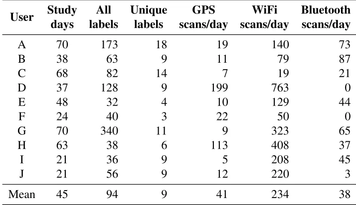
No available datasets were adequate for our evaluation. We created our own dataset based on real traces collected from 10 users. Each user carried an Android phone installed with Platys middleware as his or her primary phone for three to 10 weeks. The middleware collected a user’s place labels and recorded GPS, WiFi, and Bluetooth readings. The study was approved by our university’s Institutional Review Board (IRB).
Platys Reasoner’s objective is to exploit infrequent and intermittent data. The middle-ware invoked sensors only when a user labeled a place (a few times a day). However, the middleware, a background service, always listened to the sensors. Thus, the middleware received data from a sensor even when other applications invoked that sensor.
In real use, Platys Reasoner learns and predicts places continually. However, we dis-abled the reasoner’s learning modules during data acquisition, enabling users to label places without any bias and to avoid the possibility that if the reasoner were to begin predicting a place accurately, the user might stop labeling that place, thereby providing us insufficient ground truth for evaluation. The middleware reminded users to label their current place at random intervals. Thus, we captured how a user naturally labels places, which we use as a baseline to evaluate active learning.
Table 1 summarizes the data we acquired. Our dataset contains a variety of users (one faculty member, one postdoc, and eight graduate students from two departments; seven male and three female), differing in their mode of transportation (drive or walk), mobility across states and countries, and frequencies of sensor data collection.
5.2
Evaluation Metrics
We treat place recognition as a classification problem and evaluate its performance via precision= T PT P+F P, recall = T PT P+F N, and F-measure= 2× precision×recall
precision+recall, whereT P,
Table 1: Summary of the data acquired in user study.
User Study All Unique GPS WiFi Bluetooth
days labels labels scans/day scans/day scans/day
A 70 173 18 19 140 73
B 38 63 9 11 79 87
C 68 82 14 7 19 21
D 37 128 9 199 763 0
E 48 32 4 10 129 44
F 24 40 3 22 50 0
G 70 340 11 9 323 65
H 63 38 6 113 408 37
I 21 36 9 5 208 45
J 21 56 9 12 220 3
Mean 45 94 9 41 234 38
Typically, these metrics apply to a binary classification problem. However, place recog-nition involves multiple classes (each place is a class). Thus, we use the one-versus-the-rest strategy Bishop [2006] in which we calculate a per-class F-measure for each place as a class, treating rest of the places as another class. Then, we assess the overall place recognition accuracy by averaging the per-class F-measures.
5.3
Comparison with Two Traditional Classifiers (Supervised)
Platys Reasoner employs a traditional classifier and the benefits it offers arise due to active and semi-supervised learning enhancements. We evaluated the benefits of each enhance-ment on logistic regression and SVM.
5.3.1 Active Learning
To evaluate the claim that Platys Reasoner’s active learner reduces place labeling burden, first, we temporally ordered all labeled instances corresponding to a user. Recall that our learning algorithms were disabled during data acquisition so that the order in which labels were assigned was user controlled or random if the user simply labeled when the middle-ware reminded the user to. Retrospectively, we want to check what would have happened had the places been labeled according to the active learner’s expectations. Thus, for a given number of labelsn, we trained a traditional classifier employingnlabeled instances in the order that (1) the user labeled them, and (2) the active learner would have expected the user to label them. We used the rest of the labeled instances for testing.
compar-isons). We stop atn = 7since eight is the maximal number such that each user labeled at least two places eight times in our dataset (we need at least two classes to train a classifier and at least one labeled instance to test).
1 2 3 4 5 6 7
0.3 0.4 0.5 0.6 0.7
Number of labels trained with
F-Measure (a v eraged across users) Logistic regression Logistic regression +
Active learning
1 2 3 4 5 6 7
0.3 0.4 0.5 0.6 0.7
Number of labels trained with
F-Measure (a v eraged across users) SVM
SVM + Active learning
Figure 8: Platys Reasoner’s active learner compared with two traditional classifiers.
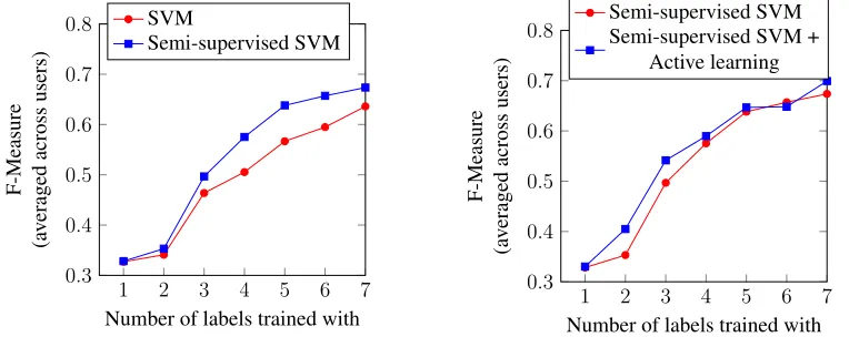
We found a difference in the baseline and active learning versions of the classifiers with as few as three labels. For example, at n = 3, an active learning version of logistic regression performs on par with the corresponding baseline at n = 6. This supports our claim that an active learner can significantly reduce a user’s place-labeling effort.
5.3.2 Semi-Supervised Learning
We claim that Platys Reasoner’s semi-supervised learner, which employs both labeled and unlabeled instances, recognizes places with better accuracy than a traditional classifier which employs labeled instances only. We evaluated this claim via SVM. As shown in Figure 9 (left), the semi-supervised SVM achieves a higher F-measure than SVM.
1 2 3 4 5 6 7
0.3 0.4 0.5 0.6 0.7 0.8
Number of labels trained with
F-Measure (a v eraged across users) SVM Semi-supervised SVM
1 2 3 4 5 6 7
0.3 0.4 0.5 0.6 0.7 0.8
Number of labels trained with
F-Measure (a v eraged across users) Semi-supervised SVM Semi-supervised SVM +
Active learning
Figure 9: Platys Reasoner’s semi-supervised and active learning compared for SVM.
First, with a few place labels (n ≤ 3in our dataset), active learning improves the semi-supervised SVM’s F-measure noticeably. Next, with several place labels (accordingly, more sensor readings), semi-supervised SVM’s F-measure is in par with its active learning version. That is, whereas active learning is valuable in the initial phases of training, semi-supervised learning can compensate for a user’s non-compliance to place labeling requests in later phases of training.
5.4
Comparison with Two Staypoint-Based Approaches (Unsupervised)
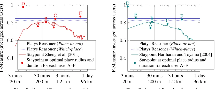
We compared Platys Reasoner with two staypoint-based approaches Hariharan and Toyama [2004], Zheng et al. [2011]. However, the comparison was nontrivial for three reasons. First, a staypoint-based approach requires fixed values for place radius and duration. Since the optimal values for these parameters are not obvious, we varied them fromh3 minutes, 20mitoh1 day, 96kmi.
Second, a staypoint-based approach does not distinguish one staypoint from another. Thus, it can only predict whether a data instance belongs to a staypoint or not. To make a fair comparison, we implemented a variant of Platys Reasoner called Place-or-not that distinguished whether a data instance belongs to one of the labeled places or not (and call the version that recognizes specific places asWhich-place).
Finally, a staypoint-based approach requires several sensor readings to perform well. Although the approach itself does not require labels, our evaluation requires labels as ground truth. Since only a few sensor readings are labeled in our dataset, we requested our users to provide additional ground truth. Six of the original 10 users did so. For each of the six users, we provided a web-based (large-screen) interface showing sensor read-ings and asked the user to indicate whether the user was in one of labeled places or not at the corresponding time. To assist users in recalling this information, the interface showed GPS coordinates on a map, provided other sensor readings at that time as well as the user’s previous and next labeled place.
Figure 10 compares the F-measures for Platys Reasoner and two staypoint-based ap-proaches. Our findings are three fold.
(1) Place-or-not performs better than both staypoint approaches we compared with. The F-measures for Platys Reasoner, unlike those of staypoint approaches, are straight lines since since they do not depend on place radius and duration.
(2) The parametersh30 minute, 200miused by Zheng et al. [2011] are reasonable, but not optimal for all users (dots in the figure indicate individually optimal values).
0.4 0.6 0.8 1 3 mins 20m 30 mins 200m 3 hours 1.2km 1 day 96km A B C D E F
Place Radius and Duration (log scale)
F-Measure (a v eraged across users)
Platys Reasoner (Place-or-not) Platys Reasoner (Which-place) Staypoint Zheng et al. [2011] Staypoint at optimal place radius and duration for each user A–F
0.4 0.6 0.8 1 3 mins 20m 30 mins 200m 3 hours 1.2km 1 day 96km A B C D E F
Place Radius and Duration (log scale)
F-Measure (a v eraged across users)
Platys Reasoner (Place-or-not) Platys Reasoner (Which-place) Staypoint Hariharan and Toyama [2004] Staypoint at optimal place radius and duration for each user A–F
Figure 10: Platys Reasoner compared with two staypoint-based approaches.
6
Developer Study
We now evaluate Platys as application development platform. We evaluate the platform from the perspectives of two kinds of stakeholder—application developers and end-users. We evaluate the:
1. efficiencyof the middleware in assisting developers with respect to time and effort, and
2. effectivenessof the middleware in enabling high-quality place-aware applications from both the developer and end-user perspectives.
6.1
Study Design
Our study design terminology is adapted from Juristo and Moreno [2001]. For convenience, we summarize the key terms (with their mapping to our study) in Table 2.
6.1.1 Study Unit
The unit of our study was the location-aware application to be developed. We conceived an application called theRinger Manager Service (RMS)that automatically sets the ringer mode of a user’s mobile phone based on location. The functional requirements of the application were the following.
• RMS must continually monitor a user’s location.
Table 2: A brief description of the study-design terminology we adopt.
Term Description Examples in our study
Study unit An object on which the study is being conducted.
A location-aware appli-cation.
Subject A participant in the study. A developer exercising an approach.
Parameter A characteristic held invariant throughout the study.
Complexity of the soft-ware to be developed. Response variable A variable measuring the
out-come of a study.
Usability of the product, development time. Factor A characteristic studied that
affects a response variable
Development platform
Alternatives The different values of a fac-tor studied.
Android location man-ager vs. Platys middle-ware.
Undesired variation A characteristic that we wish to keep invariant, but cannot.
Programming experi-ence of the subjects.
• RMS must automatically adjust the ringer mode of a user’s phone according to the user’s setting for the current location, setting it to a default if the user has not specified a ringer mode for the current location.
• RMS must also act as a notification manager in the scenario when a user’s phone is in silent mode and the user misses a call by sending a notification to the caller. The notification should contain location information, e.g., “Sorry for missing your call; I am in a lecture hall right now.”
So that it is representative of a variety of location-aware applications, the RMS was designed to use location for multiple purposes—informative, task execution, and social disclosure. In addition to the functional requirements, we also specified a set of require-ments to enhance the usability and privacy of RMS:
• RMS should be able to capture ringer mode settings for as many locations of interest to a user as possible.
• RMS should accommodate the changing location needs of a user.
• RMS should equip users with utmost control on privacy.
The usability requirements were specified at a fairly high level to encourage developers to use their natural intuitions in addressing them. Note that a generic notion of usability of a mobile application depends on several factors. Our focus here was to evaluate the usability of RMS specific to its location-aware aspects.
Next, we divided the experimental unit into four subunits. Each subunit represented an essential step in the development of RMS.
1. Preparation (prep). Setting up the development environment, familiarizing with the application specification, and acquiring the necessary background knowledge.
2. Location representation and acquisition (loc). Representing the location at a suitable level of abstraction and developing techniques for acquiring it.
3. Core functionality (core). Implementing the functionality of (a) providing users an op-tion to set the ringer mode, (b) automatically changing the ringer mode based on the location, and (c) sending a notification to a caller on a missed call when the phone is silent.
4. Usability and privacy (usability). Enhancing the usability and privacy of RMS.
6.1.2 Subjects
Our study involved 46 students enrolled in a graduate-level computer science course (36 graduate, four undergraduate, and six online graduate; 27 male and 19 female). The study was approved by our university’s IRB. Subjects earned points (counting toward the course grade) for completing the study. However, participation in the study was not mandatory. Nonparticipants were offered an alternative task to earn points equivalent to what they would earn by participating in the study.
6.1.3 Study Mechanics
We asked each subject to develop RMS from the functional and usability requirements. In addition to developing the application, subjects were asked to keep track of the time and effort they expended for development by answering atime and effort surveyafter each development session. The survey asked what subtasks each subject worked on during a session, how long he or she spent on each of those subtasks, and how difficult he or she felt a particular subtask was. The subjects reported time in hours and minutes, and difficulty on a scale ofvery easy,easy,medium,difficult, andverydifficult. Finally, the subjects were asked to produce a document describing how they addressed the usability requirements in their application.
6.1.4 Parameters
• Requirements: For uniformity, all subjects were given both functional and usability re-quirements, which remained unchanged, for the most part, during the study. Minor changes and clarifications were announced via a website and all subjects notified via email.
• Deliverables: The deliverables of the project were the same for all subjects: time and effort surveys, source code of the project, and a document describing the usability and privacy-enhancing features of the application.
• Study duration: All subjects were given a four-week period to submit all deliverables (we allowed one additional week for one subject for medical reasons).
• Software tools: All subjects were required to use Eclipse 3.6+ as the development plat-form and Android Development Tools (ADT) plug-in for developing Android applica-tions at API level 10.
• Development device: Each subject was provided with an Android development phone for the duration of the study unless he or she opted to develop on a suitable personal Android device.
6.1.5 Response Variables
Table 3 summarizes the responses variables we analyzed. For each subject, thetimesubtask
was calculated as the sum of times reported by the subject for thesubtaskacross multiple sessions. Here,effortsubtask is the arithmetic mean of effort ratings reported by the subject for thesubtaskacross multiple sessions.
We analyzed the overall time and effort required to develop RMS from two perspectives— including and excluding the preparation time. We defined the following variables:timeRMS
as the sum oftimesubtaskfor eachsubtask;effortRMS as the arithmetic mean ofeffortsubtask
for eachsubtask; andtimeRMS−prepandeffortRMS−prepas above but respectively
exclud-ingtimeprepandeffortprep. The motivation was to compare subjects in terms of their
expe-rience in location-aware application development. A developer needs to perform the prepa-ration subtask only for the first location-aware application he or she develops. Since most of our subjects were inexperienced in location-aware development, we usedtimeRMS−prep
andeffortRMS−prepas indicators of the time and effort expended by experienced location-aware developers.
Next, we analyzed the quality of the applications produced from two perspectives.
1. Developers. We employed the following well-known software metrics McCabe [1976], Pressman [2005] as indicators of the quality of the software modules produced.
Table 3: A description of the response variables we analyzed. Thesubtaskvariable in the table can take valuesprep,loc,core, andusability.
Response variable Study unit Description
timesubtask subtask
timeRMS RMS Development time reported by subjects.
timeRMS−prep RMS afterprep
effortsubtask subtask
effortRMS RMS Perceived effort as reported by subjects.
effortRMS−prep RMS afterprep
M CC
RMS
McCabe’s cyclomatic complexity.
N oLM Number of levels per method.
N oS Number of statements.
N oM Number of methods (for a fixedN oS).
usability RMS Extent to which an RMS implementa-tion meets usability and privacy require-ments.
• N oLM: The number of levels per method reflects the number of logical branches each method has on average. The metric is a key indicator of code readability. We measured theN oLM of the project as the mean of theN oLM for each method in the project.
• N oS: The number of statements in a project is an indicator of the general maintain-ability of the code. We measuredN oS as the sum of non-comment and non-blank lines inside method bodies of a project.
• N oM: The number of methods in a project (for a fixed N oS) is an indicator of the modularity of the code.
2. End-users. We performed a qualitative analysis of each application (end product) pro-duced. The objective of the analysis was to understand the techniques employed by each subject to meet the usability and privacy requirements outlined earlier. The techniques employed by an application allude to the potential usability problems associated with the application.
6.1.6 Factors and Alternatives
Our objective was to study the effect of the location abstraction employed—position or place. The abstraction a developer employs depends on the location acquisition platform available. We divided subjects into two equal sized groups as follows. TheControl Group
which provides position information from GPS or the network. ThePlatys Groupemployed the Platys middleware as Murukannaiah [2012] for location acquisition platform, which provides place information.
The choice of Android SDK as the alternative of Platys is motivated by two factors. First, the Android SDK is the de facto standard platform for developing location-aware Android applications. Thus, our findings could be of interest to a large developer com-munity. Second, although platforms with similar objectives as Platys are described in the literature (reviewed in Section 7), none are available for easy deployment on the Android platform to enable a fair comparison with Platys.
6.1.7 Undesired Variations
We identified three sources of undesired variation and sought to mitigate the associated risks as follows.
• Subjects’ experience:Differences among subjects’ programming experiences is inevitable in our setting. A subject’s programming experience can influence the time and effort he or she expends on a programming task. To minimize the risks associated with the dif-ference in subjects’ skill sets, we conducted a prestudy survey asking subjects about their experience in general, Android, and location-aware programming. We assigned approximately an equal number of subjects at each level of experience to the Control and the Platys Groups. Assignment within each level of experience was completely ran-dom, though. However, most of our subjects (86%) were new to developing mobile or location-based applications. Thus, each subject was required to complete a simple location-based Android programming exercise prior to the study to acquire basic knowl-edge of Android programming.
• Communication between subjects:We noticed that communication among subjects across the Control and Platys Groups could influence a subject’s 1. strategies for enhancing us-ability and privacy of RMS, and 2. survey responses to the perceived effort, if the subject figured out whether he or she belonged to Platys or Control Group. In order to minimize the risks associated with this factor, the groups were called Group 1 and Group 2. Fur-ther, we strongly discouraged subjects from communicating with each other about the task. All communication between the subject and the researchers were through one-to-one channels (email or meetings) instead of a message board. Although the requirements for both groups were the same, we provided group-specific guidelines accessible only to the group members.
6.2
Analyses Performed
At the end of the study, we verified the submissions and found 12 submissions to be in-complete (seven from Control and five from Platys Group). An inin-complete submission did not address each functional requirement. Our results are based on 34 complete submis-sions, which comprise of 16 Control and 18 Platys subjects. Our analyses considered the following statistics:
• mean of the sample fort-test;
• variance of the sample forF-test; and
• average rank of the sample for Wilcoxon’sranksum-test (typically, difference in aver-age ranks of two samples indicate a difference in corresponding medians).
For each statistic, we tested the null hypothesisHN ullagainst the alternative hypothesis
HP latys or HN either described in Table 4. We use Platys and Control subjectsto refer to
the two samples studied and Platys and Controldevelopers to refer to the corresponding populations.
Table 4: Null and alternative hypotheses. Each test verified the null hypothesis (HN ull)
against one of the alternative hypotheses (HP latysorHN either).
ID Hypothesis
HN ull There is no difference in thestatisticfor Platys and Control developers.
HP latys Thestatisticfor Platys developers is less than that for Control developers.
HN either There is a difference in thestatisticfor Control and Platys developers.
All tests accommodated samples of unequal sizes. Thet-tests were conducted assuming unequal variance between the two populations (also called Welch’st-test). Fort-tests, we verified that the corresponding samples passed the Kolmogorov-Smirnov normality test. A one-tailed or two-tailed test was conducted depending on whether the null hypothesisHN ull
was tested against the alternative hypothesis HP latys orHN either, respectively Freund and
Perles [2004], Hollander and Wolfe [1999].
6.3
Results and Discussion: Time and Effort
Figures 11 and 12 compare the development times and effort ratings reported by Control and Platys subjects during the development of RMS. We also summarize the results of hypothesis testing in the figure (to the right of each plot). We compared difference in means (µ) and variances (σ2) for times reported, and median (
e
x) for effort ratings. Comparisons involving<and 6=indicate the alternative hypothesesHP latysand HN either, respectively.
10 20 30 40
P C
timeRM S (hours)
µP < µC
(p = 0.113)
σP2 < σ2C
(p =
0.657) 0 20 40 60 80 100
C
P
effortRMS (%responses) e
xP <xeC
(p = 0.281)
10 20 30 40
P C
timeRM S−prep(hours) µP <
µC ∗ ∗ (p = 0.007) σ2
P < σ2C
(p =
0.297) 0 20 40 60 80 100
C
P
effortRMS−prep (%responses) e
xP <exC ∗
∗ (p = 0.010)
Figure 11: Comparison of the time (left) and effort expended (right) by Platys (P) and Control (C) subjects to develop RMS, highlighting significant differences.
We now discuss the motivations behind our hypotheses and whether the observations supported our hypotheses. In case of inconsistencies, we discuss if an undesired variation could have influenced the result.
6.3.1 Preparation
As part of the preparation for RMS development, each developer must become familiar with the functional and usability specifications of RMS, and set up the development envi-ronment. Other than these steps, the only other task for a Control developer is to become familiar with the Android location API. However, a Platys developer must install the Platys middleware, and become familiar with both the Platys place API and AIDL (Android In-terface Definition Language) to interact with the middleware.
Clearly, a Platys developer must perform more preparatory work than a Control devel-oper. Thus, we hypothesized that Platys developers would expend more time and effort for preparation (HControl). Not surprisingly, the observations supported our hypothesis.
The difference in variances was not surprising, either, considering the fact that Control developers have noticeably less preparatory work to do. However, these results are not dis-couraging. The important question is whether the extra cost expended by Platys developers for preparation pays off elsewhere.
6.3.2 Location representation and acquisition
0 5 10 15 20
P C
timeprep(hours)
µP 6=
µC ∗ ∗ (p = 0.001)
σ2
P 6=σ2C ∗
∗
(p =
0.001) 0 20 40 60 80 100
C
X
effortprep (%responses) e
xX 6= e
xC ∗ ∗ (p = 0.013)
0 5 10 15 20
P C
timeloc(hours)
µP <
µC ∗ (p = 0.081)
σ2
P < σ2C ∗ ∗
(p =
0.011) 0 20 40 60 80 100
C
P
effortloc (%responses) e
xP <xeC
(p = 0.138)
0 5 10 15 20
P C
timecore(hours)
µX 6=µC
(p = 0.311)
σ2
X 6=σC2
(p =
0.577) 0 20 40 60 80 100
C
X
effortcore (%responses) e
xP 6=xeC ∗
(p = 0.088)
0 5 10 15 20
P C
timeusability (hours)
µP <
µC ∗ ∗ (p = 0.021)
σ2P < σ2C ∗ ∗
(p =
0.018) 0 20 40 60 80 100
C
X
effortRMS (%responses) e
xP <exC ∗
∗ (p = 0.021)
Figure 12: Comparison of the time (left) and effort expended (right) by Platys (P) and Control (C) subjects to develop RMS’ subtasks, highlighting significant differences.
and acquisition time is likely to be high. For a Platys developer who is acquainted with the Platys middleware, representation and acquisition come at a low cost. That is, a Platys developer can represent location as place and acquire place by interacting with the Platys middleware. Thus, we hypothesized that Platys developers would spend less time and effort for representing and acquiring location (HP latys). The difference in the means and
• A pair of spatial coordinates with a fixed radius for each location. Four subjects imple-mented this technique (25%).
• A pair of spatial coordinates with a configurable radius for each location. Two subjects implemented this technique (12.5%).
• A conceptual unit (i.e., a location with a logical name) backed by a pair of spatial coordi-nates. However, the list of conceptual units is preconfigured by the developer, e.g., one of the preconfigured list washome andoffice. Three subjects implemented this technique (18.75%).
• A conceptual unit backed by a pair of spatial coordinates and a user can add any number of conceptual units. Seven subjects implemented this technique (43.75%).
We noticed that 75% of the Control subjects attempted to represent location at an abstraction higher than position. This explains why Control subjects spent significant amounts of time for representing and acquiring location and points toward the need for architectural support to represent and acquire location as a high-level abstraction.
Further, there was insufficient evidence to reject the null hypothesis for difference in the effort ratings (although the median effort rating for Platys subjects was smaller). This outcome could be explained by the different levels of formalization between the Platys and the Android APIs. Since the Platys middleware is not a commercial product, we encoun-tered unanticipated patterns of middleware usage from the subjects, which required minor changes to the middleware in early stages of the study. Working with a middleware that changed, albeit slightly, might have made development more difficult for Platys subjects.
6.3.3 Core functionality
Given that developers who have already represented location know how to acquire it at the desired level of abstraction, the core functionality to be implemented by Control and Platys developers is the same. Thus, we hypothesized that there is no difference in the time and effort expended by Control and Platys developers for implementing the core functionality (HN either).
The results pleasantly surprised us. Although the difference in times reported were not significant between Control and Platys subjects (p= 0.311), the efforts reported by Platys subjects were significantly less than those of Control subjects (p = 0.088). This leads us to conjecture (for future study) that a better representation of location can lead to reduced effort in implementing the core functionality.
6.3.4 Usability
privacy policies. Further, the Platys middleware notifies applications of newly added and stale places so that they can adapt to the changing location needs of a user. However, for a Control developer, incorporating such features involves a nontrivial investment of time and effort. Thus, we hypothesized that Platys developers would spend less time and effort for enhancing usability than Control developers (HP latys). The observations supported our
hy-potheses for the difference in mean and variance of times reported as well as the difference in median effort expended. In each case, the null hypothesis was rejected at a significance level of about 2%.
6.3.5 Ringer Management Service
From the perspective of inexperienced location-aware developers, Platys developers would spend extra time and effort in preparation but that expense would pay off in representation and acquisition, and enhancing usability. Thus, we hypothesized that Platys developers would do at least as well as Control developers, if not any better (HN either). The
observa-tions supported our hypothesis. Further, the p-values obtained indicate that the time and effort expended by Platys developers would be smaller (although not significantly).
From the perspective of experienced location-aware developers, Platys developers gain some advantages over Control developers. Thus, we hypothesized that Platys developers would do better than Control developers in time spent and effort expended (HP latys). The
observations supported our hypotheses about mean time and median effort at about 1% significance level.
However, the observations didn’t support our hypothesis that the variance in time re-ported would be smaller for Platys developers than Control developers (for both inexperi-enced and experiinexperi-enced developers). Further investigation revealed that a significant amount of variance in times reported by Platys subjects originates from the variance in times for the core functionality task. Such variance could arise because of the fact that subjects had no incentive to submit the deliverables early. The Platys subjects would have spent more time on the core task while Control subjects spent some of their time on other aspects of the project.
6.4
Results and Discussion: Software Metrics
In this and the next section, we analyze the quality of the applications produced. In order to understand quality from developers’ perspective, we analyzed well-known software metrics (computed from the source code of the applications developed by subjects). Because place is a high-level abstraction and the Platys middleware supports representing and reasoning about place, we hypothesized that applications (software modules) produced by Platys de-velopers are easier to comprehend (M CC), easier to read (N oLM), shorter (N oS), and more modular (N oM), i.e.,HP latysfor each software metric we analyzed.
2 3 4
P C
M CC
µP <
µC ∗ ∗ (p = 0.001)
σP2 < σ2C ∗ ∗
(p =
0.002) 1.5 2 2.5
P C
N oLM
µP <
µC ∗ ∗ (p = 0.001) σP2 < σ2C
(p = 0.101)
500 1,000 1,500
P C
N oS
µP < µC
(p = 0.272)
σ2P < σ2C ∗ (p =
0.072) 5 10 15
P C
N oM (forN oS = 100)
µP < µC
(p = 0.725)
σ2P < σ2C
(p = 0.705)
Figure 13: Comparison of the software code metrics for the RMS implementations pro-duced by the Platys (P) and Control (C) subjects. Also shown are the results of hypothesis testing, highlighting significant differences (to the right of each plot).
summarizes the results of hypothesis testing for each metric. Our observations support
HP latysfor bothM CC andN oLM at less than 1% significance level. This indicates that
applications developed by Control developers, who employ position abstraction, are likely to be harder to comprehend than those developed by Platys developers.
However, the results were not according to our intuition forN oS andN oM. Although each metric was slightly better for Platys subjects, the evidence was not significant to reject the null hypothesis (at 5% significance level) in either case. It was surprising that the amount of code produced was not significantly different across groups although Control subjects spent more time in doing so than Platys subjects.
An analysis of the variance (also summarized in Figure 13) revealed that the variance in
N oS for Control subjects was significantly higher than that for Platys subjects. This vari-ance could result from the varying extents to which Control implementations met usability requirements (since the analyzed applications meet all functional requirements) We con-jecture that the mean code size of Control implementations would be higher if all Control implementations met all usability requirements (Section 6.5).
6.5
Results and Discussion: Usability
In order to understand quality from end-users’ perspective, we performed a qualitative eval-uation of the usability of RMS applications developed by Control and Platys subjects. To do so, we analyzed the usability description document submitted by each subject and verified the claimed features by testing the subject’s application. In the process we discovered fea-tures that were not claimed, but implemented, which could potentially affect the usability of RMS. Table 5 summarizes, in three categories, major techniques employed by subjects to address the usability requirements. Next, we discuss potential impact these techniques may have on the usability of RMS.
Table 5: A summary of the techniques implemented by Control and Platys subjects to address the usability requirements.
Category Technique Implemented Control Platys
(% sub.) (% sub.)
Visualization
Logical names as a list. 56.25 77.78 Logical names on a map. 6.25 22.22 Unlabeled markers on a map. 25.00 0.00 Spatial coordinates as a list. 12.50 0.00
Evolution
Notify new and stale locations automatically. 0.00 83.33 Users manually add new locations. 81.25 0.00 No support for evolution. 18.75 16.77
Privacy
Specify a policy for each social circles. 0.00 77.78 Specify a policy for each contact. 18.75 0.00 Share with anyone in the contact list. 6.25 0.00 Ask user each time before sharing. 62.50 11.11 Specify to share with all or none. 12.50 11.11
6.5.1 Visualization
An RMS implementation must display locations of interest to a user for informative pur-poses, e.g., for showing ringer modes associated with locations. Most Platys subjects showed locations as a list of previously tagged places (and some marked the place on a map when clicked). Note that showing places on map is not always a viable option for Platys-based RMS implementations since 1. not all places may have a spatial component; 2. a user may configure the Platys middleware to not share spatial coordinates with RMS at all.
and the list of spatial coordinates reduce thememorabilityof the user interface and a list of spatial coordinates may not beintelligible.
6.5.2 Evolution
As a user visits different locations, RMS should enable the user to set (or reset) an appro-priate ringer mode for each location. The Platys middleware notifies registered applications of new locations tagged by the user as well as locations that have become stale. Most Platys subjects implemented RMS so as to take advantage of these notifications and prompt the user to add (or delete) ringer modes for new (or stale) locations. A few Platys subjects ignored these notifications and didn’t address the requirement of evolving RMS as the lo-cation needs of a user change.
The RMS implementations by most Control subjects provided a user an option to man-ually add locations as needed, but only 37.5% of them provided an option to delete stale locations. Requiring the user to manually add each location can be time consuming (as opposed to automated support). Further, being unable to delete stale locations can easily
clutterthe user interface. The rest of the Control subjects’ implementations preconfigured the list of locations (e.g., home, office, andrestaurant) allowing a user to neither add nor delete locations. Such preconfigured lists don’t necessarilygeneralizeto a variety of RMS users.
6.5.3 Privacy
The Platys middleware provides a user an option to specify which of the user’s locations are to be shared and with whom (one or more social circles). A majority of Platys subjects implemented RMS to consult the Platys middleware (through appropriate method calls) before sharing the location with a caller. In contrast, a majority of the RMS implementa-tions by Control subjects consulted the user before sharing location. Although this option is privacy preserving, it is too intrusive. Asking a user each time before sharing location defeats the very purpose of RMS to automatically notify callers. The other options imple-mented by Control subjects were also suboptimal: specifying a policy for each contact is
time consuming, and automatically sharing location with anyone in the contact list is too
coarse. Finally, none of the RMS implementations by Control subjects enabled a user to specify thegranularityat which location is to be shared (e.g., logical names only, include spatial coordinates, and so on).