Survey of some Popular Android applications used
in Post Disaster management Scenario
Sayantan Chanda Sharmistha Dey * Arunava Nath Mouli Dutta Krischina Koley
Abstract:In our very recent past, several natural calamities and disasters has taken many lives and causes damage of valuable properties. Like, Nepal earthquake in May 2015 or Kedarnath Flood in June 2013 or a devastating Tsunami in Japan in 2004, caused a huge destruction and trouble for us.Natural disaster is almost next to impossible to be prevented, but measures can be taken to eliminate or reduce the possibility of trouble. Regardless of the many forms a disaster may take, the actual damage to collections is usually caused by fire or water.
Communication during disaster time is very crucial for both the rescue team as well as victim. Emergency never comes with prior intimation. Keeping it in mind, disaster recovery application development is one of the most familiar topics throughout the world, for the current technological era. Though most of the software are for the victims, but a few has been developed for the rescuers also.
The aim of this paper is to analyse some popular android applications and find out the strength, weakness and relevance of such applications in the post disaster management scenario.
Keywords: ArcGIS,Catastrophy,Disaster,Hazard, UBAlert
MOTIVATION OF THE WORK:
In the last few years our world has visited so many tragedies and natural calamities like tsunami in Middle east Asia , earthquake in Nepal,Pakistan or flood in Kedarnath. Those disasters has taken a lot of lives and always brings a damage of valuable properties also. We cannot be able to prevent any disaster, but an alert system or some rescue can be organized for this calamities.
As per the research, we can understand that pre-disaster alert is much harder than post disaster management. In this scenario, we can take necessary action on that particular place where the disaster takes place. In this way, as soon as possible the rescue team can start their work. In current days, all the necessity should be provided by the management team. But the initializing of the rescuing should be started with the help of the softwares which are discussed in this document.
INTRODUCTION:
“Disaster”-the term is about widespread destruction and distress.Inspite of being robust and technologically advanced, our human civilization has faced many problems due to natural calamities and disasters, for several years. In our recent past, we have seen that the Nepal earthquake in May 2015, has taken so many lives and causes a huge loss in properties, was an unavoidable situation to face.Previously, the flash flood in Kedarnath of
Uttarakhand (June 2013) has made us horrified with a new level of ruins and destruction.It was very difficult to locate and rescue the alives and take them back to a safer place, in such emergency situation.
Such dissaters like flood, Tsunami or earthquake has compelled the scientists and researchers to think and innovate applications to rescue and locate victims and communicate during disaster scenario.
Disasters is an unexpected and unfavorable event in nature when occurs brings great damages to lives and livelihoods. These unfortunate event either natural or man induced can exceed coping capacity of the affected region or country and resulting in terrible losses of lives, plants, animals and property. When a disaster occurs social and economic life of the affected region is paralyzed1. Climate changes are frequently occurring all over the globe. These calamitous changes including destruction of forest, rapid urbanization, extraordinary growth of industry, population growth, changes in weather patterns and environmental demolition like pollution are associated with an increasing frequency of major disasters2.United Nations Development Programme(UNDP) defines disaster as “a social crisis situation occurring when a physical phenomenon of natural, socio-natural or anthropogenic origin negatively impacts vulnerable populations ... causing intense, serious and widespread disruption of the normal functioning of the affected social unit.”
WHAT IS DISASTER?
The United Nations defines a disaster as a serious disruption of the functioning of a community or a society. Disasters involve widespread human, material, economic or environmental impacts, which exceed the ability of the affected community or society to cope using its own resources.
Disaster Management can be defined as the organization and management of resources and responsibilities for dealing with all humanitarian aspects of emergencies, in particular preparedness, response and recovery in order to lessen the impact of disasters.
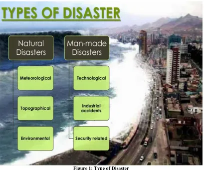
CLASSIFICATION OF DISASTER: There are four main types of disaster:
Figure 1: Type of Disaster
Environmental emergencies: Including technological or industrial accidents, usually involving the production, use or transportation of hazardous material, and occur where these materials are produced, used or transported, and forest fires caused by humans.
Complex emergencies: Involving a break-down of authority, looting and attacks on strategic installations, including conflict situations and war.
WHAT IS POST DISASTER?
Disaster is a sudden, calamitous event bringing great damage, loss, and destruction and devastation to life and property. The damage caused by disasters is immeasurable and varies with the geographical location, climate and the type of the earth surface/degree of vulnerability. This influences the mental, socio-economic, political and cultural state of the affected area. Generally, disaster has the following effects in the concern areas:
1. It completely disrupts the normal day-to-day life. 2. It negatively influences the emergency systems.
3. Normal needs and processes like food, shelter and health are affected, and deteriorate depending on the intensity and severity of the disaster.
NEED FOR POST DISASTER MANAGEMENT
As disaster may not be prevented in most of the time,so it’s easier to recover the victims rather than pre- disaster management.
There are many popular softwares have been developed to prevent the damages.
This paper focuses on some popular softwares working on post disaster management.
UB ALERT:
The UB alert is dedicated to the mission of saving lives by providing information management solutions that enable organizations for response to disaster. UB-Alert application gives you all the information you need when it comes to disasters happening across the world.
The main functionalities of this software are: Registered Users:
Advantage:
Global emergency warning platform validates the
reliability of the reported content and then immediately alerts those who may be impacted, depending on the severity and location.
Ub Alert application gives you all the information you need when it comes to disasters happening across the world. With data collected from both verified sources and users like you, you’ll instantly have access to everything you need to know about an event.
Developed By: The State university of New York (University of Buffalo)
ARCGIS:
ArcGIS is a geographic information system (GIS) for working with maps and geographic information. It is used for: creating and using maps; compiling geographic data; analyzing mapped information; sharing and discovering geographic information; using maps and geographic information in a range of applications; and managing geographic information in a database. This technology enables organizations to create responsible and sustainable solutions to problems at local and global scales. When a disaster strikes, knowing what you need and how to find it can be the key factor that saves lives, resources, and critical infrastructure. GIS is an essential technology for all phases of emergency management preparation, mitigation, response, and recovery. GIS can map and model potential disasters to help visualize critical vulnerabilities and damage consequences.
Functionalities of this software:
1. ArcGIS is designed as a secure system with controlled access. We are committed to continually advancing security and solidifying your trust through
accreditations and operations.
2. Create, share, and manage geographic data, maps, and analytical models using desktop and server applications. Deploy GIS across your organization and on the web.
3. Mapping: Use ArcGIS maps to compile geographic data, perform spatial analysis, and share your geographic information online.
4. Analysis: Combine information from many independent layers by applying a rich set of spatial operations.
5. Geographic Data Management:Build, manage, and share geographic information using features and tabular data, imagery, online maps, 3D, and much more. Manage and share enterprise information collections across your organization.
Advantages:
Seamlessly explore data for the entire world in three dimensions.
Fuse your local data with data and services from ArcGIS Server, ArcIMS, Open Geospatial Consortium WMS, and ESRI-hosted ArcWeb Services.
Perform GIS analysis tasks (e.g., visibility, direction finding, and proximity search).
Answer geographic questions and get answers you can share with others.
Use maps and data from your own GIS servers.
Developed By: James H.
STORM EYE SOFTWARE FOUNDATION
:-The Storm Eye Software Foundation is dedicated to the mission of saving lives by providing information management solutions that enable organizations and communities to better prepare for and respond to disasters. Storm Eye provides detailed storm tracking information and weather radar images overlaid on Google Maps. For each storm, Storm Eye provides important information such as the storm's location relative to your location, where the storm is heading, estimated time of arrival (ETA), the storm's intensity, hail probabilities, and maximum hail size.
Figure 3: Storm Eye
The main functionalities of this software are :
1. Organization Registry: Storm Eye functions by downloading data from the National Weather Service for the selected WSR-88D weather radar. It captures information about the places where each organization is active and the range of services being provided. 2. Request/Pledge Management System: The
application uses GPS to detect the phone’s current position and sends this data through the text messages to the member which user already insert in to the application for help. We have tested our system assuming that a fllod will hit in the region of Chittagong, India. We have utilized ten users in specified area who have installed the proposed application on their mobile phones.
3. Shelter Registry: The disaster management consists of four fundamental
Steps such as mitigation, preparedness, response, and recovery. Among these steps, the emphasis of our work is the preparedness which is the development of a system for the action plan of disasters.
4. Inventory Management: Rotate the map using the compass sensor. Tracking storm timing and mapping, monitoring.
5. Situation Awareness: It's automatically finds your location using GPS or network. Manually enter your location with an address/zip code. So that people can collaboratively capture the current disaster situation. 6. Volunteer coordination: Helps NGOs keep track of
all their volunteers, their contact information, project allocation, availability and skills to help them
distribute staff resources.
It works on Wi-Fi satellite communication with fully distributed network platform.
This software is running average storm heading arrow in the top right corner and it's view a list of all of the storms at the selected radar.
Advantage:
Tracking Storm timing and mapping, monitoring.
Rotate the map using the compass sensor.
Automatically finds your location using GPS or network.
Developed By: Cody D.Smith
SAHANA SOFTWARE FOUNDATION:
The Sahana Software Foundation is dedicated to the mission of saving lives by providing information management solutions that enable organizations and communities to better prepare for and respond to disasters. This was originally developed by members of the Sri Lankan IT community as an immediate aftermath of the 2004 Indian Ocean earthquake and tsunami. It is an open source alert system for disaster management. It has been developed on FOSS (free open source software) approach and has been made available to all at free of cost.
The main functionalities of this software are:
1. Missing Person Registry: An online bulletin board of missing and found people. It captures information about the people missing and found, and also the information of the person seeking them.
2. Organization Registry: A collaborative “Who is doing what, where” tool which enables tracking of the relief organizations and other stakeholders working in the disaster region. It captures information about the places where each organization is active and the range of services being provided.
3. Request/Pledge Management System: An online repository where all relief organizations, relief workers, government agents and camps can effectively match requests of aid and supplies to pledges of support. It tracks aid provision from request to fulfillment.
4. Shelter Registry: Keeps track of the location and basic data of shelters in the region. It also provides a geospatial view to plot the location of the camps in the affected area.
5. Inventory Management: Tracking the location, quantities, expiry of supplies stored for utilization in a disaster
6. Situation Awareness: Gives an overview of the event and allows people to add information on what is happening on the ground. It features the ability to plot a note and a photo with additional information on a Map, so that people can collaboratively capture the current disaster situation.
distribute staff resources.It works on Wireless LAN satellite communication with fully distributed network platform.
This software is running very good research opportunities but the main disadvantage is that it needs to be authorized by a local government. Also the study reveals that it is not very effective to deal with heterogeneous data like semi-structured data, XML etc.
The features of Sahana Software Foundation:
1 A fexible and modular architecture, including a front-endcontroller that makes it easier to manage and synchronizesystem-wide tasks and events.
2: Support for security at the modular and framework level,and support for Internationalization and Localization ofcontent.
3: Web-based and console based commands to ease setupand configuration of Sahana and its database.
Developed By: Srilanka Government's centre of national operations.
CONCLUSION:
This popular softwares made by different governmental or private agency,are the good performer in their respective areas,but most of them focuses on alert delivery system,which is very essential in case of disaster.Some softwares are free but some needs to be bought with a moderate amount.they use technologies like wifi or bluetooth.An improvement regarding better efficiency and quality of services can be done.
REFERENCES:
1. https://play.google.com/store/apps/details?id=com.bum pnetworks.ubalert&hl=en,
2. https://www.arcgis.com/features/sahanafoundation.org /
3. https://en.wikipedia.org/wiki/Sahana_FOSS_Disaster_ Management_System
4. http://www.schoolofsanjuan.com/school/disaster/www /index.php?mod=home&act=about
5. https://wiki.guildwars2.com/wiki/Storm_Eye 6. https://www.arcgis.com/
7. http://www.esri.com/software/arcgis/arcgis-for-desktop