Science knowledge to local
implementation
Anton Eitzinger
Science knowledge to local
implementation
Anton Eitzinger
Dissertation zur Erlangung des Doktorgrades
an der Fakult¨
at f¨
ur Geowissenschaften
der Ludwig–Maximilians–Universit¨
at
M¨
unchen
vorgelegt von
Anton Eitzinger
aus Frankenmarkt
Zusammenfassung
Problem. Der Klimawandel trifft die Landwirtschaft in Entwicklungsl¨andern am h¨artesten. Obwohl viele Studien ¨uber die Folgenabsch¨atzung zum Klimawandel existieren, beurteilen nur wenige eine r¨aumlich differenzierte Auswirkung und stellen konkrete Anpassungsstrate-gien f¨ur Kleinbauern zur Verf¨ugung. Viel h¨angt auch davon ab, ob die Bauern den Kli-mawandel wahrnehmen und ob sie davon ¨uberzeugt sind dass er sie treffen wird. Es fehlt Wissen ¨uber die Wahrnehmung von Klimarisiken durch Landwirte, und dar¨uber, wie ihre Entscheidungsfindung bei gleichzeitiger Einwirkung von mehreren Riskien beinflusst wird. Klimawandelanpassung findet bereits an vielen Orten statt, die Skalierung von erfolgreichen Beispielen scheitert oft. Was fehlt, sind neue tools, die ein kosteneffizientes Monitoring und Evaluierung des Fortschritts in der Anpassung an den Klimawandel erm¨oglichen.
Forschungsziel. Die hier beschriebene Forschung zielt darauf ab den Klimawandele-influss r¨aumlich zu evaluieren, die Wahrnehmung der relevanten Akteure zu verstehen und effiziente tools f¨ur Monitoring und Evaluierung zu entwickeln, die eine Anpassung durch Bauern evaluieren k¨onnen.
Methoden. Die Studie verwendete mehrere Methoden um den Prozess der Anpassung zu studieren und Wissenschaftsergebnisse zur lokalen Umsetzung von Strategien in einer Fallstudie als gekoppeltes Mensch-Umwelt-System (HES) zu zeigen. Als Erstes wurden Geographische Simulationsmodelle zur Ermittlung von r¨aumlich differenzierte Auswirkung eingesetzt. Zweitens wurde ein Ansatz von Mentalen Modellen verwendet, um Unter-schiede in der Wahrnehmung von Experten und Bauern zu untersuchen und Klimarisiken im Zusammenhang mit anderen Risiken zu verstehen. Drittens wurde ein Prototyp f¨ur Monitoring und Evaluierung der Umsetzung von Anpassungsstrategien entwickelt.
Resultate. Das DSSAT-Modell wurde zur Feststellung der r¨aumlich differenzierten Folgenabsch¨atzung verwendet. Die Ergebnisse zeigen, dass die Ertragsvariabilit¨at f¨ur aus-gew¨ahlte Anpassungsoptionen zwischen den geographischen Standorten variiert. F¨ur die Fallstudie Cauca in Kolumbien zeigen die Ergebnisse der Mentalen Modelle, dass Experten und Bauern die Bef¨urchtungen der Risiken unterschiedlich wahrnehmen. Die Clusteranal-yse ergab vier Typologien von Wahrnehmungen bei Bauern. Die Verwendung von Geo-Farmer in einem der vier Pilotprojekte zeigte eine zunehmende Anwendung und Skalierung klimagerechter Landwirtschaftspraktiken durch die Bauern nach Demonstrationsveranstal-tungen auf.
Summary
Problem. Impacts from climate change on agriculture are expected to hit economic liveli-hoods in developing countries hardest. Although many studies exist on climate change im-pact assessment, few of them assess spatially differentiated imim-pact gradients and translate them into actionable strategies and possible adaptation pathways for smallholders. The success of implementation of these strategies relies in no small extent on farmers’ percep-tions of climate change including their knowledge and beliefs how it will affect them. There is not enough knowledge about farmers’ perception of climate risks and how it influences decision making under multiple stressors. However, climate change adaptation is already happening in many places, but scaling of good practices often fails. What is missing are new tools that allow cost-effective monitoring and evaluation of climate change adaptation strategies at scale.
Goals. The research described here aimed for spatially assess impact-gradients and derive options for adaptation, understand climate-risk perceptions of relevant actors and develop tools for monitoring and evaluation to measure and track the evidence of farmers’ adoption of adaptation strategies.
Methods. This research used multiple methods to study the adaptation process and bring science output to local implementation of strategies in a case study as a coupled human-environmental system (HES). First, geospatial simulation modelling was used to analyse impact-gradients and adaptation options. Second, a mental model approach was used to study differences in experts and farmers perceptions and better understand climate risks in the context of other risk. Third, a prototype was developed for cost-effective monitoring and evaluation of the implementation of adaptation strategies.
Results. The Decision Support System for Agrotechnology Transfer (DSSAT) model was used to identify impact gradients for dry beans in Central America and dry beans and maize in East Africa. Findings show that yield variability for selected management options varies between sites. For the case study Cauca in Colombia, findings of analysing mental models of experts and farmers reveal that they perceived concerns and enablers for adaptation similarly, but risks and barriers to adaptation differently. The cluster analysis of farmers’ risk rankings revealed four typologies of farmers based on their perceptions. Using the GeoFarmer application in one of the four pilots uncovered the increased adoption and scaling of climate-smart agriculture practices after demonstration sessions.
Zusammenfassung vii
Summary ix
List of Figures . . . xiii
List of Tables . . . xiv
I
Part ONE: Synopsis
1
1 Introduction 3 1.1 Climate Change Impacts, Vulnerability, Adaptation and Resilience . . . 31.2 Climate Change in Colombia . . . 4
1.3 Climate Change Communication and Policy . . . 5
1.4 A premise: sustainable adaptation of farmers livelihood systems . . . 5
1.5 Digital Agriculture . . . 6
2 Research Problem and Gaps 7 2.1 Climate change impact assessment on crop performance . . . 7
2.2 Perceptions of climate change . . . 8
2.3 Monitoring and Evaluation of implementation . . . 9
3 Objectives and Research Questions 11 3.1 First objective and research goal . . . 11
3.2 Second objective and research goal . . . 11
3.3 Third objective and research goal . . . 12
4 Study Area and Conceptual Framework 13 4.1 Geographic Scope of research . . . 13
4.2 The case study region . . . 13
4.3 Motivation for selecting the case study region . . . 14
5 Methods and procedures 19 5.1 Geospatial Simulation Modeling (GSM) for assessment of impact-gradients 19
5.1.1 Decision Support System for Agrotechnology Transfer (DSSAT) . . 21
5.1.2 Climate data and climate model predictions . . . 21
5.2 Using a Mental Model Approach to understand perceptions . . . 22
5.2.1 SMMA applied for climate change risk perceptions . . . 22
5.2.2 Sampling and data collection . . . 23
5.3 Monitoring and Evaluation of climate change adaptation using ICT . . . . 23
5.3.1 Development of ICT tools in the context of smallholder agriculture 24 5.3.2 Development of a prototype as GeoFarmer application system . . . 25
5.3.3 Performance evaluation of GeoFarmer . . . 26
6 Results 29 6.1 Climate Change Impact-Hot-Spots . . . 29
6.1.1 Impact-Hot-Spots for dry beans in Central America . . . 30
6.1.2 Simulated options for adaptation strategies in Central America . . . 30
6.1.3 Simulated options for adaptation strategies in East Africa . . . 33
6.1.4 Crop exposure to climate risks in the case study area Cauca Colombia 34 6.2 Risk perceptions and decision making for adaptation . . . 34
6.3 Monitoring climate change adaptation using ICT tools . . . 36
7 Discussion 45 7.1 Relevance of findings for climate change adaptation . . . 45
7.2 Appraisal of HES as a theoretical framework for climate change adaptation 47 7.3 The problem of the local scale for impact modelling . . . 48
7.4 Why is it important to understand perceptions . . . 49
7.5 The importance of co-creation with local actors . . . 50
7.6 Need for better monitoring and evaluation of the adaptation process . . . . 51
7.7 Strengths and weaknesses of the approach . . . 51
7.8 Open issues for further research . . . 52
8 Conclusion 55
Bibliography 57
II
Part TWO: Manuscripts
73
Publication I 76
Publication II 94
Publication IV 137
Publication V 151
III
Part THREE: Appendix
165
A DSSAT model configurations 167
Configurations file . . . 167
B Materials for Fieldwork in Cauca 183 Experts interviews template . . . 183
Template for experts online ranking . . . 194
Farmers interview template . . . 197
Cards for farmers interviews . . . 206
Data-analysis . . . 209
C GeoFarmer manuals 219 Trainings manual for Lushoto pilot . . . 219
Manual for Monitoring and Evaluation in Climate-Smart Villages . . . 244
Development of 5Q survey trees . . . 244
List of Figures
4.1 The geographic scope of research. . . 144.2 The case study area in Cauca Colombia. . . 15
4.3 HES Framework as a conceptual framework for this research . . . 16
5.1 Approaching the HES framework with methods and tools. . . 20
5.2 GSM modelling steps and simulations domains. . . 21
5.3 Mental Models approach: Overview of the conceptual framework . . . 24
5.4 Overview of GeoFarmer application systems’ architecture . . . 25
6.1 High-Impact-Spots in Central America . . . 31
6.2 Yield variability and management options for Central America . . . 32
6.3 Yield domain for different agronomic management practices in East Africa 38 6.4 Differences in experts and farmers perceptions in Cauca Colombia . . . 39
6.5 Causal-loop-diagramm of farmers’ livelihood systems in Cauca Colombia . 40 6.6 Use-case diagramm of GeoFramer . . . 41
6.7 GeoFarmer Pilot - Adoption of CSA practice in Lushoto Tanzania . . . 42
List of Tables
Introduction
Global climate change is one of the current issues concerning science and society largely. New ways of collaboration between science and society need to provide knowledge for decision makers to reduce risks from climate change while being able to meet sustainable development goals [121].
Invisible and slowly progressing climate change as a risk makes it elusive; and people’s perceptions are constrained by temporal-, social-, geographical-distance and by uncer-tainty [144]. Science of climate change is driven by globalizing research failing to provide sufficiently reliable predictions on the local scale [59]. While public concern and climate change awareness have gained more weight recently among society [87, 82], implementation of policies to reduce emissions and risks from climate change is still slow [14, 56].
In the climate change discussion, agriculture plays a double role: on the one hand, it is one of the leading contributors to global greenhouse gas emissions (GHG) [125]; on the other hand, risks from weather fluctuations and seasonal anomalies already affect agricultural yields and food security in many regions of the world [92]. Furthermore, impacts from climate change on agriculture are expected to hit economic livelihoods in developing countries hardest [48, 58].
1.1
Climate Change Impacts, Vulnerability,
Adapta-tion and Resilience
In the climate change literature, vulnerability includes various concepts and elements in-cluding sensitivity or exposure to harm and the lack of adaptive capacity [67]. Vulnerability and adaptive capacity, however, are not determinants of climate change policy support. Factors determining peoples’ policy support are their beliefs concerning the causes and local impacts of climate change [129].
Adaptation is a process of adjustment to actual or expected climate and its effects. In human systems, it seeks to avoid harm or take advantage of opportunities. Actions that aim for maintaining the state of the current system are categorised as incremental
associated with transformational adaptation [67]. Adaptation is a human-environment interaction in a spatial and temporal setting [155]. Also, adaption needs to be framed in a socio-political process, involving authority, knowledges ad subjectivities across scales by multiple actors [40]. Finally, non-climate stressors, i.e. land tenure, environmental degradation, globalization of markets, market failures, state fragility and armed conflicts, among others, affect smallholders on rural livelihoods and can contribute equally or more to vulnerability of farm households [98].
In the current practice, the focus of adaptation is often framed as top-down problem-focused approach. Thus, several authors call for pathway thinking in the decision-making process of adaptation to consider dependencies, interactions and constraints in the human-environment system [162], and, using a multiple exposures framework instead of sectorial approaches and technical fix solutions [44].
The Paris Agreement frames adaptation in a different and broader context of multiple stressors to reduce farmers’ socioeconomic vulnerability first, then address risks from dis-aster events and finally support the development of socio-ecological resilience to cope with climate change [155].
In the literature, adaptation in agriculture is associated with three main strategies [78, 117]:
• Coping strategies for current variability and existing systems on a low signal of cli-mate change (e.g., heat-tolerant varieties, adaption of management practices) • Systemic changes in moderate climate change signal (e.g., farm diversification, new
crops)
• Transformation of systems without adaptation to a strong climate change signal (e.g., abandon crops and change to livestock system, leave agriculture)
Resilience is a useful lens to link ecological and social contexts to tackle the climate change problem [32]. The International Panel on Climate Change (IPCC) defines Resilience as:
”The capacity of social, economic, and environmental systems to cope with a hazardous event or trend or disturbance, responding or reorganising in ways that maintain their essential function, identity, and structure, while also main-taining the capacity for adaptation, learning, and transformation.” [67, p.5]
1.2
Climate Change in Colombia
For this reason, urgent actions are required from all Colombian actors to increase re-silience to climate change, including the government, institutions and civil society. As for most Latin American countries, understanding how institutions shape decisions is crucial for Colombia [37]. Historically, institutional integration between local and national levels in Colombia has been difficult. Smallholders in Colombia are at risk from multiple stres-sors, including climate change, trade liberalization, and violent conflicts, and policies have been addressed separately in the past [44].
The violent conflict internally displaced a cumulative population of 6.9 million persons from 1985 to 2015 [107], the majority of displaced people moved from rural to urban areas. The persistent armed conflict and related social vulnerability in rural areas have led to profound mistrust in the state [90].
1.3
Climate Change Communication and Policy
In the Paris Agreement, the United Nations Framework Convention on Climate Change (UNFCCC) has established a goal of limiting the average temperature to well below 2 de-gree celsius above pre-industrial levels by the end of the twenty-first century [158]. Achiev-ing this goal would significantly reduce the long-term risks and impacts of climate change. While national greenhouse gas inventories are monitored through National Determined Contributions (NDCs), an analogue method to monitor adaptation processes does not exist. While there is a consensus that adaptation is needed, there is no clear process estab-lished to track and monitor adaptation that would provide evidence where adaptation is already occurring and what are the enablers that drives adaptation [155]. Also, policy im-plementation is often delayed on the national level because of variability-driven uncertainty of local impact [123]. The role of science in adaptation policy and practice is to provide science for adaptation and provide research results that are solution-oriented and at the service for society [18]. Further, science should provide the methodological frameworks to effectively document adaptation in a global stocktake approach, as it was mandated in the Paris Agreement [155].
1.4
A premise: sustainable adaptation of farmers
liveli-hood systems
The agriculture sector in developing countries is especially vulnerable to climate change [9] and needs to become more resilient in the future through actions initiated by governments, supported by the international research and development community [2, 122]. Smallhold-ers’ food production in less developed countries faces many challenges and risks, often with substantial adverse effects on food security and livelihoods [103].
them directly as low [11]. The success of agricultural climate policies relies in no small extent on farmers’ perceptions of climate change including their knowledge and beliefs how it will affect them [28, 108].
The sustainable livelihood framework (SLF) has been widely used as a standard ap-proach to studying farmers’ livelihood systems [141, 120]. The livelihood apap-proach helps to understand the diversification of rural livelihoods as part of a coping strategy regarding hazards from climate shocks [15]. Using approaches from systems dynamics (SD) [147], the dynamics between livelihood capitals in agricultural systems could be analysed and better understood [20, 154].
Finally, agriculture needs to become smarter to tackle climate changes. Promoting both adaptation and mitigation at the same time, is a promising way forward in agriculture to foster agricultural practices and technology that sustainably increase productivity, make farmers resilient to climate shocks while reducing greenhouse gas emissions from agriculture where possible [89], often referred to as Climate Smart Agriculture (CSA).
1.5
Digital Agriculture
Digital agriculture is considered to be promising for overcoming some of the impediments that farmers have always been facing in agriculture; efficient access to relevant knowledge and sharing of information [5]. In the age of digitisation, information and communication technology (ICT) or digital farming can help to overcome some of the impediments and help farmers to better adapt to new threats like climate change [38]. In this context, smart farming [53] using ICT components is a promising solution to tackle some of this challenges and has been pushed recently by many national and international initiatives, with some progress in developing countries [6].
However, the use of ICT in agriculture does not always lead automatically to higher yields and profits for farmers. To be successful, the implementation of ICT initiatives needs to recognise the local context of capabilities and user needs, and it must recognise the problem of the gender digital divide which can drive marginal groups of smallholders into new digital poverty [94, 5].
Research Problem and Gaps
2.1
Climate change impact assessment on crop
per-formance
In recent years, a substantial number of research papers have been published revealing the impact of climate change on agriculture [66]. Most of these research studies assess the threat of climate change for agriculture and food production on a global and regional scale [127, 164, 124, 151]. Although outputs of these studies are essential instruments for awareness building of policy and decision makers [25, 73], they are not suitable to communicate climate change risks to farmers [46]. Farmers perception is primarily shaped by variability-driven local change [123, 47]. Even more, results from global and regional climate change assessments are often not applicable to derive adaptation strategies for the most important spatial scale in agriculture, the community and farm level.
Also, future climate scenarios, mainly provided by the International Panel on Climate Change (IPCC), have limitations because of the coarse geographical and temporal scale of climate models [113] and because of uncertainties from variability between multi-model predictions [83]. Another relevant issue in agricultural impact assessment is incomplete historical weather data records, especially in developing countries [91, 114]. To tackle the limitations on available data, scientists use statistical downscaling methods [115], com-bined approaches of remote sensing data and historical climate records [140] and weather simulators [77], to provide consistent climate data for modelling.
A reasonable number of studies apply crop models (CMs) together with climate sce-narios, i.e., a current climate baseline compared with future climate scesce-narios, to assess the climate change impact on crop performance [75, 52, 143, 41]. Universities and research centres mostly develop CMs, but they are focusing on food crops, i.e., cereals, legumes and root crops among others. For cash crops like coffee, cocoa or other crops that have not been in the focus of public funded research, advanced CMs models are not publicly available to climate change scientists.
niche modelling [128, 21], apply a fuzzy logic approach on edaphoclimatic requirements [164], or use climate envelope models [62] to create a spatial distribution of a suitability index for each crop. A limitation of empirical approaches, however, is that these models can not provide information about the impact on productivity. Also, they can usually not disaggregate the impact based on abiotic factors and management practices, i.e., crop varieties, soil types and agronomic management. Thus, estimations of crop responses to climate change using climate information and empirical approaches are not enough to derive accurate adaptation strategies at the local level.
Despite the lack of accuracy of climate change impact assessments, impact gradi-ents, and, consequently, required adaptation measures vary significantly between sites [24]. Therefore, practical adaptation actions require assessments of the spatial distribution of impact gradients that would need different pathways of adaptation [78, 117].
Gap 1: While many studies focus on the impact of climate change on agriculture and crops, few studies assess spatially differentiated impact gradients and translate them into actionable strategies for smallholders and possible adaptation pathways; there is a need to assess spatial accurate impact gradients and simulate options for adaptation strategies.
2.2
Perceptions of climate change
The next problem is that we do not understand well farmers’ perception of climate change and how it is related to adoption rates of adaptation strategies [104]. Thus, the commu-nication of impacts from climate change that requires adaptation of existing systems has been difficult for experts [101], because long-term predictions are not relevant for farmers [144]. The perception of facts that are far in distance and time is explained in the literature as the perceived psychological distance between impacts and individuals [142]. Farmers, especially in developing countries, are more affected by inter-annual climate variability and short-term risks like impacts from shocks, rather than long-term changes.
The success of climate change policies, however, relies on farmers’ perception about risks from climate [108, 28] and how they see climate risks in the context of other risks in their livelihood system. There is a growing literature on how perceptions influence farmers’ decision-making for up taking adaptation strategies [102]. Many of these studies focus on comparing meteorological data with peoples’ memories of historical climate events [19]. They hypothesise that farmers’ perceptions about climate risks are related to adaptive be-haviour [68]. Thought agreeable, climate change research should integrate risk perceptions in the context of the farmers’ livelihood system without focusing on climate risks only. Because in the context of smallholder farming in developing countries farmers are often exposed to multiple stressors, including climate risks, but not only. If multiple stressors act simultaneously on farmers’ decision making, vulnerability is enhanced, and adaptive capacity to climate risks constraint [120].
consequences for the communication of adaptation policies. In other research areas than climate change, studies have shown that understanding the differences in risk perceptions between experts and farmers can be essential for risk communication and more critical to avoid policy failure [16]. Experts as climate change actors often promote the imple-mentation of agricultural adaptation strategies as a top-down approach based on impact assessments [51], rather than employing a participatory bottom-up approach to understand perceptions and local dynamics. As a result, experts recommend one fit all solutions [43], and they do not take into account the local dynamics between livelihood capitals at the farm level.
Top-down policies are often impact-based, bottom-up approaches, in turn, focus on social domains like vulnerability, adaptive capacity or community needs [119, 51]. Experts should acknowledge that adaptation is a social process [1]. Thus, the social dimensions and enablers together with the relevant actors for implementation must be understood to make adaptation successful.
Gap 2: There is not enough knowledge about farmers’ perception of climate risks and how it influences decision making under multiple stressors and composed dynamics be-tween livelihood capitals in their livelihood system. Research is needed to understand farmers’ perception of climate risks within the context of their livelihood system and how different farmers and experts perceptions are.
2.3
Monitoring and Evaluation of implementation
When it comes to the implementation of adaptation strategies, experts as implementers are facing several challenges, like, difficulties in defining what adaptation strategy should be in practice (spatial prioritisation), identifying what works where (spatial allocation), and tracking the implementation to show evidence of successful adaptation (spatial scaling). What experts need for efficient tracking of climate change adaptation are robust approaches for monitoring and evaluation (M&E). M&E in climate change adaptation should evaluate the efficacy of agricultural technologies, practices, services, and programs at multiple levels, from the local to the global level [88, 49]. To make that possible, M&E tools should offer continuous feedback, guidance for action, and more responsiveness to changes and emerging opportunities while testing and implementing adaptation strategies [54].
development projects is no guarantee to overcome the shortcomings that still exist for rural agricultural communities, like low ICT literacy and danger of provoking a new digital divide [94]. There needs to be more focus on studying the use of ICT for enabling the access to critical information for decision-making, coordinating actors, building and strengthening the social capital, improve communication between experts, implementers and farmers and disseminate experience for collective learning in the adaptation process [38].
Objectives and Research Questions
To fill the research gaps described in the previous chapter the following objectives and research questions are relevant to this study:
3.1
First objective and research goal
Goal 1: Spatially assess impact-gradients and simulate crop yield of different options for adaptation.
The first objective was articulated to provide modelling approaches that can be used to identify the expected impact of climate change on agricultural crop systems, spatially differentiate impact gradients and simulate responses of adaptation options.
The following first two research questions for this objective were derived:
1. Where (location) are high-impact hot-spots of climate change?
2. How can crop yields for adaptation strategies be simulated in a model and outputs translated into actionable strategies for smallholders?
For the first objective, methods and procedures were developed and applied not only for the case study area in Colombia. They were used in several projects within the geographical scope of developing countries in the tropical south.
3.2
Second objective and research goal
The second objective examines mental models for understanding perceptions and the factors that enable adaptation and successful implementation of adaptation strategies.
The following research questions were shaped:
3. What are the differences in perception between experts and farmers on climate change risks in the farmers’ livelihood system?
4. What factors on the farm level of the agricultural production system can influence decision making and may hinder the implementation of adaptation strategies?
These research questions were answered through a structured approach of applying different methods for risk perceptions in the context of climate change in the case study area in Colombia.
3.3
Third objective and research goal
Goal 3: Develop and test new tools for monitoring and evaluation to measure and track the evidence of farmers’ adoption of adaptation strategies.
5. How can the implementation of adaptation strategies be monitored and evaluated using an ICT based approach?
6. Can ICT tools be a cost-effective and scalable alternative for monitoring and eval-uation of the implementation of adaptation strategies compared to traditional ap-proaches?
Study Area and Conceptual
Framework
This section describes the geographical scope of the research and introduces to the case study region. It justifies the selection of the case study region and gives an overview of the conceptual framework used for this research.
4.1
Geographic Scope of research
Within the geographical scope of this research are regions in the tropical south, where the Research Program on Climate Change, Agriculture and Food Security (CCAFS) is addressing the increasing challenge of climate change and declining food security. CCAFS has developed the Climate-Smart Village (CSV) approach [79] as a means to agricultural research for development in the context of climate change. Action research on CSV sites seeks to fill knowledge gaps and stimulates scaling of Climate-Smart Agriculture (CSA) as a complementary approach to sustainable intensification of agricultural production [26]. This research study is relevant to several CCAFS regions (Latin America, East-Africa, and West-Africa: see Figure 4.1). Though some of the objectives were applied to different CSVs in all three regions; a more comprehensive case study was carried out in the Colombian CSV Cauca.
4.2
The case study region
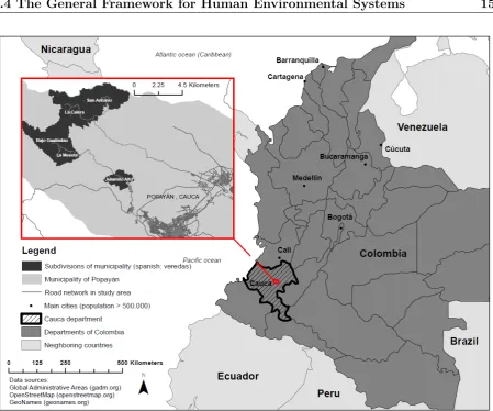
For the case study in the Cauca department in Colombia, all three objectives were applied. Being geographically close to the Pacific Ocean, the region is subject to inter-annual climate variability mainly driven by the El Ni˜no Southern Oscillation (ENSO) [112]. The CSV Cauca ranges from 1600 to 1800 masl, and major crops grown by smallholders in the study region are coffee (Coffea arabica), sugarcane (Saccharum officinarum), cassava (Manihot
esculenta), maize (Zea mays), plantain (Musa acuminata) and common beans (Phaseolus
! .!. ! . ! . ! . ! . ! . ! . ! . !. ! . ! .!. ! . ! . ! . ! . ! . ! . ! .!.!. ! . ! .!. ! . ! . ! . ! .!. ! . !. ! . ! . ! .!. ! . ! . ! . ! . ! . ! . ! . ! . Cauca 120°E 120°E 110°E 110°E 100°E 100°E 90°E 90°E 80°E 80°E 70°E 70°E 60°E 60°E 50°E 50°E 40°E 40°E 30°E 30°E 20°E 20°E 10°E 10°E 0° 0° 10°W 10°W 20°W 20°W 30°W 30°W 40°W 40°W 50°W 50°W 60°W 60°W 70°W 70°W 80°W 80°W 90°W 90°W 30°N 30°N 20°N 20°N 10°N 10°N 0° 0° 10°S 10°S !
. Case study - Obj. 1,2,3 Obj.1 ! . Obj.1 ! . Obj.1,3 ! . Obj.3 !
. Climate Smart Villages
3,000
Kilometers
´
Figure 4.1: The geographic scope of research.
under armed conflicts; hence, the region is lacking behind in infrastructure development. Five villages from a rural community of the municipality of Popayan were selected for this study (see Figure 4.2).
4.3
Motivation for selecting the case study region
According to the last agricultural census [31], farmers in Cauca have a low education level, and 52 % live in poverty according to Colombia’s multidimensional poverty index [130]. Based on data collected for this study, about 87% of farmers do not receive technical assistance, and only 11% have applied to formal credits in the past.
Cauca faces many risks for agriculture. The primary stressors alongside climate change acting simultaneously on smallholders are trade liberalisation and violent conflicts [44].
Another important reason for selecting Colombia and Cauca for the case study was a time coincidence of this study with the CCAFS program, starting its research and inter-ventions in Latin Amerika in the same year. CCAFS started its first research activities in West-Africa, East-Africa and South-Asia back in 2011, activities in Latin America and South-East Asia started in the year 2014. The time coincidence was especially relevant for the second objective of understanding farmers’ perceptions. An essential requirement for our study was that interventions from climate change researchers should not bias farmers. In fact, interviews with experts and farmers were carried out timely in summer 2014, a few month before CCAFS carried out its baseline surveys, introductory workshops and learning activities with farmer communities in the last quarter of the same year.
4.4
The General Framework for Human
Environmen-tal Systems
Figure 4.2: The case study area in Cauca Colombia.
leading to action (decision-making) and interactions, feedbacks, adaption, and learning of systems. The seven postulates in the HES framework act as guidelines for research projects and foster a comprehensive analysis of HES (Figure 4.3).
In the following, the seven postulates are described in the context of climate change adaptation.
Postulate 1 - Complementarity (P1): Human and environmental systems are two differ-ent, but complementary and interrelated systems. The HES systems development follows stages of pressure from human action that alter the state of the environmental system and affects both systems [134]. As a consequence, it requires adaptive behaviour by humans. HES is useful for vulnerability analysis and impact studies [157] where human decision-making is the critical factor to model systemic feedbacks between the two separate but coupled systems [57].
Figure 4.3: The Human-Environment System (HES) as a conceptual framework for this research. Adapted from[133].
supranational level. The level hierarchies are characterised both by downward and up-ward causation. For understanding the causal interactions between levels, the components and relationships among and between levels must be defined. In this research, the follow-ing three hierarchical levels are relevant for human systems in climate change adaptation. First, the individual farmer at the local level, secondly, experts from the regional level that interact with farmers, and third, actors at the policy level making decisions about relevant policies. For the environment system, the local climate variability was used for the first level, the regional climate represents the second level, and the earth climate system and its dynamics stands for the highest level.
Postulate 3 - Interference (P3): Climate change is a typical example of interferences between interests or regulatory mechanisms between levels. Interferences occur during decision-making and not through feedbacks from the systems. The research seeks to un-derstand what differences in perceptions between levels (experts and farmers) can lead to differences in decision making and HES interferences.
to decision-making. Although, primary feedback loops from decision making are goal-driven, based on cost-benefit decisions and easy to perceive by farmers, secondary feedback loops are more difficult to understand, even more, when farmers are focused on short-term goals. Farmers cannot often anticipate secondary feedback loops. However, they are coupled to primary feedback loops and manifest themselves as delayed environmental responses to changes in the human systems. As a consequence, adaptation is needed as a reaction to secondary feedback loops caused by human action in the past.
The promotion of CSA options as adaptation strategies leads to a win-win situation for the HES because of tackling both adaptation and mitigation in one strategy. CSA can sustainably increase productivity, make farmers resilient to climate shocks while reducing greenhouse gas emissions from agriculture where possible [89].
Postulate 5 - Decision (P5): Human systems consist of decision makers with goals and strategies. Goals and strategies can be selected according to preferences and different types of rationalities’ in human systems. Humans make decisions based on their individual liveli-hood goals and beliefs concerning the likeliliveli-hood of uncertain events and motives (internal factors). The individuals’ psychological distance to climate change and perceptions about risks shape their decision making [144, 142]. Also, perceptions of actors at various levels in the HES system can be different and lead to influence on goals and strategies. Thus, it is essential to explore the social dimension of climate change in the HES [54] and to under-stand differences in risk perceptions [132] to promote the adoption of adaptation strategies and the implementation of climate-smart agriculture at the local level.
Postulate 6 - Awareness (P6): Awareness building is crucial to enable action against the climate change problem, mainly because of its long response time of secondary feedback loops. Humans are aware of causes and consequences of climate change in different ways: non-awareness, awareness as distant cause and impact, awareness of secondary feedback from the environment and need for adaptation, and, awareness of cause and impact includ-ing the need for adaptation and mitigation actions. Identifyinclud-ing types of farmers is needed to understand farmers’ current choices and attitudes for supporting the implementation of adaptation strategies [65, 102].
Postulate 7 - Environment-first (P7): The last postulate of the HES framework [133] suggests to start with a comprehensive analysis of the environmental systems. The assess-ment of the material-biophysical environassess-ment helps first to understand the magnitude of potential climate change impacts and limits of environmental services before developing adaptation strategies.
Methods and procedures
This study is embedded in the ongoing research activities of CCAFS, a strategic collabora-tion among 15 research centres to address challenges of global warming and food insecurity (for further infor see www.ccafs.cgiar.org. The CCAFS program started its activities in 2011 and created CSVs in different tropical regions including East Africa, West Africa, and South Asia. Each CSV sites represented the size of a 10 per 10-kilometre raster grid and was selected based on the climate change impact-gradient (see objective 1), socio-economic characteristics, and strategic research partnerships. They serve as a playground to implement CSA in collaboration between experts and farmers and benchmark future transformative changes in agriculture as a response to a changing climate [145]. In 2014, CCAFS added new CSVs in two regions, Latin America and South-East Asia. The CSV in Cauca Colombia in Latin America was selected for the more comprehensive case study. The theoretical HES framework was used to frame the adaptation process in a dy-namic, coupled system with feedback loops between the human and environment system, and interferences from different decision-makers. In Figure 5.1, we show a schematic rep-resentation of the HES framework and illustrate the methods that we applied during the research. Table 5.1 shows how research methods and publications are related to goals and the HES postulates.
5.1
Geospatial Simulation Modeling (GSM) for
as-sessment of impact-gradients
For objective one of this research a widely tested series of simulation models for crop systems were used and applied spatially. Its routines were repeated for different spatial locations based on a regular raster. A method to identify spatial patterns and crop response variability under different management options was developed and used to identify hotspots (see Figure 5.2).
Figure 5.1: Research methods applied in the context of HES and climate change adaptation.
Phase Goal HES Research methods Publications
Obj.1 Spatial assess impact-gradients and simulate crop yield of different op-tions for adaptation
(P1) (P2) (P7)
Simulation modelling using climate model predictions and crop models
Eitzinger et al., 2015; Eitzinger et al., sub-mitted
Obj.2 Understand climate-risk perceptions of relevant actors and create a sys-temic view of multiple-risks in the farmers’ livelihood system that may hinder the imple-mentation of adaptation strategies.
(P1) (P2) (P5) (P6)
Interviews, qualita-tive and quantitaqualita-tive analysis, network of actors analysis, sys-tems dynamics
Eitzinger et al., sub-mitted; Eitzinger et al., submitted
Obj.3 Develop and test new tools for monitoring and evaluation to measure and track the evidence of farmers’ adoption of adaptation strategies
(P3) (P4) (P5)
Indicator-based
monitoring and
evaluation, internet communication tools (ICT)
Eitzinger et al., sub-mitted
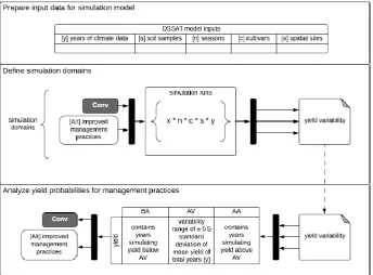
Figure 5.2: GSM modelling steps and simulations domains.
adaptation options simulated under a scenario of climate variability using historical climate data for East Africa.
5.1.1
Decision Support System for Agrotechnology Transfer (DSSAT)
DSSAT is a crop model that simulates all stages of plant development under prescribed or simulated management options [71, 63]. It uses specific sub-models for crop types. For this study, the sub-model BEANGRO [64] were used for dry beans (Phaseolus vulgaris L.), and the grain cereal simulation model CERES [23] for maize (Zea mays). DSSAT incorporates a detailed understanding of crop physiology, climate, soil and agronomy and simulates crop water balance, photosynthesis, growth, and development in a daily time step. Both sub-models BEANGRO and CERES have been validated many times, and they reflect the phenological development and yield of cultivars in DSSAT that have been calibrated by field experiments [27, 126, 106].
5.1.2
Climate data and climate model predictions
One of the main limitations to run the crop model DSSAT for regions in the tropics is data availability, especially climate data on daily time steps. Historical datasets from weather station networks often provide a monthly total of precipitation solely and mean monthly minimum and maximum temperature.
For the DSSAT simulations in Central America, the WorldClim database [60] were used to represent the current climate. For representing the future climates, a set of Global Circulation Models (GCMs) from the Intergovernmental Panel on Climate Change (IPCC) Fourth Assessment Report (AR4) [137], downscaled to the same spatial resolution as World-Clim (30 arc seconds, approximately 1 kilometres), were used. For both current and future climate data, a final step of producing daily weather data using the MarkSim weather generator [76] was applied.
an elevation model from NASA Langley Surface Radiation Budget (SRB) (Sheffield et al. 2006). The dataset was available as downscaled data to 0.1-degree spatial resolution (approximately 10 kilometres) and was used in this study as daily climate data input for the DSSAT model without modification.
5.2
Using a Mental Model Approach to understand
perceptions
A mental model approach (MM) was used to respond to the research questions from ob-jective two. The research design followed the idea of a structured mental model approach (SMMA) by Binder and Sch¨oll [16] and contextualised it for perceptions of climate change risks in the environment of multiple risks that farmers face in agriculture.
5.2.1
SMMA applied for climate change risk perceptions
The SMMA aims for understanding differences in perceptions between experts and farmers. Compared to other approaches used for analysing risk perceptions [97, 7, 34], it focuses on misunderstandings between experts and farmers, and it considers various risks in the farmers’ livelihood system. Risks need to be studied as part of a livelihood systems dy-namics [131], especially risks from climate events as they are not new to farmers and they are used to the short-term variability of climate. The SMMA combines the MM approach with the sustainable livelihood framework (SLF). It is described in [16], in brief, it suggests the following three steps:
• Define and rank livelihood capitals
• Analyze dynamics in the livelihood system
• Develop agent networks to define the social capital
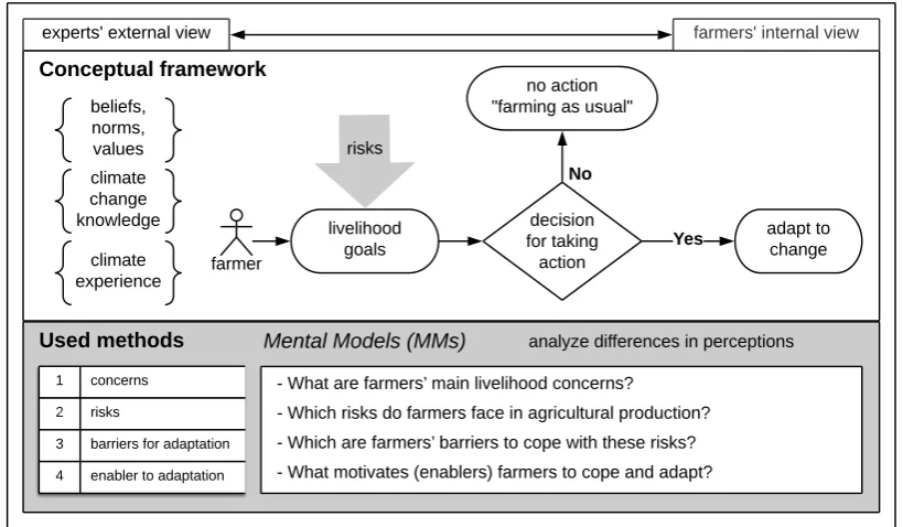
In this study, four questions were developed to assess experts and farmers views on the farmers’ concerns, risks, barriers to taking action, and enablers to take action. The following questions were asked of experts and farmers:
• What are farmers’ main livelihood concerns?
• Which risks do farmers face in agricultural production?
• Which are farmers’ barriers to adaptation to climate change?
From the individual rankings of concerns, risks, barriers, and enablers, a weighted aver-age based on the ranking of each element for the four questions was calculated. Then, the averages of experts’ and farmers’ rankings were compared. From a hierarchical clustering approach, typologies of risk perception were obtained from farmers’ rankings.
The SLF concept [135] defines sustainable rural livelihood strategies depending on liveli-hood resources that consist of five different types of capitals, i.e., natural, human, physical, financial and social capital. In this study, the social capital was analysed by elaborating, visualising and comparing a farmers’ actor-network with both groups, experts and farmers. The remaining capitals and its interactions were studied applying methods from systems dynamics [20, 154]. Concrete, a causal loop diagram (CLD) from farmers’ explanations of interactions between capitals was developed. By applying the CLD approach [147], an integrative perspective of farmers’ livelihood system was obtained, and the relationships be-tween the different variables in the livelihood system were visualised. Studying the CLD, critical feedback loops were identified as positive (reinforcing) and negative (balancing) feedback loops influencing the livelihood system of farmers in the case study area Cauca.
Figure 5.3 presents the conceptual framework and methods for addressing research questions of objective two of this study. Farmers’ perceptions regarding climate risks are shaped by their knowledge about the causes of climate change, their beliefs, social norms, and values and as well as through their experience with climate-related information and past events. Farmers have goals concerning their livelihood capitals and make decisions about investments and strategies. Based on perceptions, farmers will make decisions on adaptation strategies. In applying our approach, experts’ external views of farmers’ percep-tion were captured and compared to the farmers’ internal views. The interacpercep-tions between capitals regarding the farmers’ livelihood system were analysed.
5.2.2
Sampling and data collection
Qualitative semi-structured interviews were carried out to examine experts and farmers perceptions about farmers’ livelihood risks and barriers for adaptation in the context of climate change. The interviews were carried out in three main steps. First, open interviews with 13 experts were carried out to obtain a holistic view of experts’ perceptions. Second, based on the collected and ranked perceptions of experts, the farmer interviews were pre-pared. Third, 58 semi-structured interviews with farmers from five different villages in the municipality of Popayan were carried out.
5.3
Monitoring and Evaluation of climate change
adap-tation using ICT
Conceptual framework
farmers' internal view
beliefs, norms, values
decision for taking
action climate
experience
farmer experts' external view
climate change
knowledge livelihood
goals
adapt to change
Yes No
no action "farming as usual"
Used methods Mental Models (MMs) analyze differences in perceptions
- What are farmers? main livelihood concerns?
- Which risks do farmers face in agricultural production?
- Which are farmers? barriers to cope with these risks?
- What motivates (enablers) farmers to cope and adapt?
1 concerns
2 risks
3 barriers for adaptation
4 enabler to adaptation
risks
Figure 5.3: Overview of the conceptual framework and methods that were used to study the differences in perceptions between experts and farmers.
A prototype of an ICT application system was developed and tested to address the third objective of this research. The primary purpose of providing this system was to allow interactive feedback between farmers and experts in a spatial context. Using the system, farmers can report and communicate interactively with experts while adapting changes in technology and practices. Experts can use the system for cost-effective monitoring of ongoing implementations of adaptation strategies with farmers.
5.3.1
Development of ICT tools in the context of smallholder
agriculture
5.3.2
Development of a prototype as GeoFarmer application
sys-tem
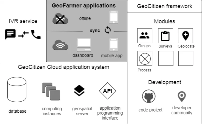
GeoFarmer was designed and developed based on the GeoCitizen framework, a geospatial system that allows for participatory community management based on a transparent and structured communication process [8]. The framework is applied as a social geoweb plat-form that combines social media with geospatial technologies allowing citizens to plan as a virtual community their living environment at a local level. In this study, the GeoCi-tizen framework and geospatial web-platform were adapted for the context of agriculture and climate change adaptation. For reasons of efficiency of code development and systems interoperability, GeoFarmer were integrated with the GeoCitizen geoweb platform, using existing modules that were modified to fit the purpose (Figure 5.4). Another reason to argue for building on an existing technological platform was that the technological platform development is not the primary goal of this research and was limited to a minimum.
Figure 5.4: Overview of GeoFarmer application systems’ architecture, developed based on the GeoCitizen framework.
The GeoFarmer prototype integrates different means of interaction (web-dashboard, a smartphone application, interactive-voice-response (IVR) call services and cloud-based backend for data integration). The platform enables interactive feedback in a spatial context between experts and farmers during the implementation of adaptation strategies and allows for active M&E of implementation and farmers adoption. The four main tasks of GeoFarmer are:
• Communicating • Solving
• Monitoring
The following modules were designed on the GeoFarmer platform:
• Spatial collection of point-observations through LEF, VFT, and farmers
• Interactive feedback loops between experts and farmers as questions and answers • Voting mechanism to make best practice knowledge for climate change adaptation
evident
• Simple survey and data-collection tools for M&E of implemented adaptation strate-gies
In the design process, a use-case diagram was developed to relate functionalities, user interfaces, and user roles. Developers emphasised for simple functionalities for users that have a low level of ICT literacy. The design was implemented as code development of different modules, application components, and the systems’ backend functionalities.
A systems performance evaluation of GeoFarmer were carried out and used to improve design and functionalities in an iterative process with experiences and field testing in four different pilots. The pilots were located within the geographical scope of this research and applied to projects implemented in the CCAFS CSVs; in Tanzania, Uganda, Colombia, and Ghana.
5.3.3
Performance evaluation of GeoFarmer
The system’s performance was evaluated through transect-walks and field testing, training and use by LEF and VFT and carrying out surveys with farmers to measure perceptions and performance-based indicators that can build evidence of impact coming from implemented agricultural technologies and practices.
The different focuses of GeoFarmer in the four pilots were:
around knowledge, attitudes and skill for practice (KAS), called the 5Q approach (Jarvis et al. 2015). The analysed data from surveys demonstrated perceptions and change of the adoption rate of CSA options at the CSV level.
• 2nd pilot: The primary focus of the second pilot in Nwoya Uganda was to repeat the first pilot and test the system in a different context. The site was characterised by lower ICT literacy of the farming community and low availability of mobile data network coverage (internet access). Quite the opposite to Lushoto, the Nwoya pilot was characterised by the low adoption of improved farming techniques on vast idle lands, low seed quality, and climate variability as critical challenges constraining agricultural production. The pilot was carried out with farmers from returning young generations of families that left the area twenty years ago because of the civil war in northern Uganda, with a low level of experience in farming.
• The 3rd pilot in Cauca Colombia: GeoFarmer was tested for crowdsourcing of farm-ers’ perceptions about climate risks and decision making in the context of other risks in their livelihood systems. This pilot was linked to the second research objective and was applying parts of the farmer interviews that were first carried out with 58 farmers in five villages across the entire Cauca department. A total number of 1240 farmers in Cauca were included in the crowdsourcing exercise. The interviews were carried out as pre-recorded IVR calls and the same four questions from objective two about concerns, risks, barriers to taking action, and enablers to take action against risks were used.
Results
This chapter emphasises the most relevant findings, sorted by the successive research objec-tives and questions (see chapter 3). The full research results can be found in the individual publications (see part II – Manuscripts).
6.1
Climate Change Impact-Hot-Spots
The first research objective focused on a comprehensive analysis of the environmental systems exposure to climate change (HES postulate 7) and the spatial distribution of impact gradients using a geospatial simulation model. It was addressed by responding to two research questions. The first question needed to resolve the spatial distribution of expected impact gradients from climate change on specific crop systems. The first research question was: Where (location) are high-impact hotspots of climate change? The answer to this question was provided in Publication I of this dissertation.
A simulation model for crop systems, the Decision Support System for Agrotechnology Transfer (DSSAT) model, was used and adapted by adding a programming routine, to spatially repeating its procedures of plant growth simulation on a regular raster. Both a current climate baseline and future multi-model predictions were used together with treatments of agronomic management and soil characteristics, for running the model. Re-sults of yield differences (future yield minus current yield) were obtained as a geographical raster grid. Distance statistics were applied to identify significant outliers, and high-impact hot-spots (HIS) were classified in three different impact gradients:
• Adaptation spots, from pixels whose negative z-values of spatial association were equal to or greater than one standard deviation of the mean (68%)
• Hotspots, from pixels whose negative z-values were more significant than two stan-dard deviations of the mean (95%).
6.1.1
Impact-Hot-Spots for dry beans in Central America
The modelling approach was applied for dry beans (Phaseolus vulgaris L.) and an area that covers four countries in Central America (Guatemala, Honduras, El Salvador and Nicaragua). The adaptation spots and the hotspots all lie within the areas that currently grow dry beans, while the pressure spots mostly lie outside them. Hotspots (red negative HISs) are concentrated from Lake Nicaragua to the northern coast of Honduras along the Central American dry corridor. Other areas currently used for dry beans cultivation and identified as positive HISs (green within the hatched areas) are promising for future development of dry bean production in the region, i.e., Guatemalan highlands, central areas of Nicaragua towards Atlantic coast to where bean production has already expanded in recent years. However, pressure spots are often close to the current agricultural frontier, and in this areas, it will cause social and political pressure to allow agriculture to migrate into these areas. Some of this area classified as pressure spots are areas currently occupied by other land use activities or even are areas under environmental protection (see Figure 6.1).
The second research question asked for translating the model outputs into actionable adaptation strategies that can be implemented by experts and farmers. The second research question was: How can crop yields for adaptation strategies be simulated in a model and outputs translated into actionable strategies for smallholders? The answer to this question was provided in Publication I and Publication II of this dissertation.
Simulation domains of different management options were defined in DSSAT as fac-torial arrangements of climate scenarios, soil types, different planting seasons, different crop cultivars and spatial sites, to respond the second research question. The necessary information for designing model treatments was obtained from expert consultations and farmer interviews. The model treatments design represented a farmers’ conventional crop management (control) and selected management options as adaptation strategies. Yield variability for control and management options (Figure 5.2) were obtained from the model and used to derive actionable adaptation strategies. The modelling approach was applied for dry beans (Phaseolus vulgaris L.) in four countries of Central America and dry beans and maize (Zea mays) in four CSV sites in East Africa.
6.1.2
Simulated options for adaptation strategies in Central
Amer-ica
repre-Figure 6.1: Outliers from yield change of dry beans in Central America in the first planting season (in Central America called Primera). Pressure spots are more than one standard deviation of the mean higher yield HIS (green), and hotspots are more than two standard deviations of the mean lower yield (red). Hatched areas are the main bean-growing areas; white points are the 15 selected bean production sites.
sentative for soils in Central America. Finally, three levels of fertiliser applications were simulated, no fertiliser application, fertiliser mix I and fertiliser mix II. All simulation op-tions were run for current climate using worldclim data and future climate from downscaled CMIP3 multi-model predictions and daily weather data that were derived from monthly climate data using MarkSim (see section 5.1.2 for details on climate data) .
The design of simulation domains was, therefore:
n
2 y o n 3 n o n 2 c o n 2 s o n 3 m o
Where, y = years of climate, n = planting seasons, c = cultivars, s = soils and m = management option (fertilizer).
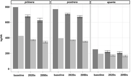
season. Fertilizers give significant increases in yield, i.e., with no fertiliser option, yields were only 34% of those with F2.
Figure 6.2: Yields from 4439 pixels in Central America for dry beans cultivars ICTA Ostua and BAT 1289 at two levels of fertiliser (F1, F2) and two soils (Generic medium silty loam, Generic medium sandy loam) with a current climate and b 2020s future.
Country the average change in bean yield [%]
all municipalities in municipalities accounting for 50% of total production
% of municipalities with expected yield loss gt 10%
El Salvador -7 / -1 / -7 -6 / -1 / -10 33 / 0 / 25
Guatemala +1 / +6 / -2 -2 / +5 / -8 10 / 0 / 20
Honduras -9 / 0 / -4 -9 / -1 / -5 43 / 0 / 14
Nicaragua -8 / +7 / -4 0 / +2 / -3 29 / 0 / 12
6.1.3
Simulated options for adaptation strategies in East Africa
A similar modelling approach was applied in four different landscapes across East Africa: i) Lushoto in the Usambara Mountains in Tanzania, ii) Rakai in the Kagera basin in the southwestern region west of Lake Victoria, iii) Hoima in southwestern Uganda in the western part of the Great Rift Valley, and iv) Nwoya in northern Uganda. The DSSAT simulation framework was used to assess four different management options and compare them with a farmers’ conventional crop management. For preparing the simulation do-mains, semi-structured surveys were carried out with experts and farmers. A total of 128 surveys were carried out in two sites, Lushoto in Tanzania and Hoima in Uganda. Com-pared to Central America where future multi-model predictions were used to compare yield variability between current and future climate scenarios, in this analysis data of 27 years (1979-2005) of historical climate (see section 5.1.2) were used to analyse current climate variability and how it affects yield levels. For soil variables, data from the Land Degra-dation Surveillance Framework (LDSF), a spatially stratified hierarchical sampling design aimed at assessing essential land and soil health metrics across diverse landscapes, were used. LDSF provided soil data at plot level for 16 samples each site and data could be used to calculate soil variables as input for DSSAT, instead of using generic soil characteristics like for Central America.
Four alternative management options as simulation domains were designed for the simulations: (i) organic fertilizer domain (OF), (ii) inorganic fertilizer domain (IF), (iii) combined organic and inorganic fertilizer domain (OI) and (iv) not taking into account the soil water balance by using the irrigation domain (IR). Finally, yield variability from the four management options was compared with yields from a farmers’ conventional crop management (CT).
An example of findings is shown in Figure 6.3. Regarding dry bean yield variability and management options can be observed, that in Lushoto Tanzania in the first planting season (long rains) all management options reach yield levels above average (AA) in more than 50% of 27 years. The lowest level was 65% for CT and the highest of 82% of years for IR. Entirely the opposite can be observed for the second season (short rains) in Lushoto, where most years have yield levels below the average (BA), and no management option except IR can increase the number of years with average yield levels (AV) or AA yield levels.
In the other sites in Uganda (except Nwoya), the second season in Hoima and both seasons in Rakai, show a better model response to the other management options OF, IF and OI. Farmers’ conventional crop management CT show for all sites higher share of BA years.
Findings show that yield response from management options vary between sites. Espe-cially the combination of organic and inorganic fertiliser (OI) achieved highest yield levels for most sites and planting seasons. Based on this findings, specific recommendations for the four sites were developed:
as well as for both seasons of maize cultivation, the most effective management option in Lushoto would be IR. Variability between different soil domains in Lushoto was found to be higher than for the other three landscapes. Soil erosion and water availability are considered major limiting factors for crop growth according to the DSSAT model. Farmers need to implement soil conservation measures and increase water productivity on their farms to reduce the risk of years with potential low yields.
Simulations for Hoima and Rakai show that water is not the primary limiting factor for high yields, rather soil fertility. In Hoima, simulations of dry beans did not show a high response to management options in the FPS but indicate that all four options OF, IF, OI and IR would improve yield domains for the SPS. Simulations of maize yields show a high response to fertilisation. Especially OI would significantly increase AA years (up to 66% of AA years in FPS and 100% in SPS).
More findings for maize and yield variability related to soil types can be found in Publication II.
6.1.4
Crop exposure to climate risks in the case study area Cauca
Colombia
The site selection of the CSV Colombia was carried out by CCAFS through vulnerabil-ity analysis, including impact assessment of climate change to cropping systems. The modelling approach using the DSSAT model was not applied for the case study area in Cauca, however, before starting our work of research objective two in Cauca, a crop ex-posure assessment was carried out using the empirical crop-niche-model Ecocrop. The modified model of the original Ecocrop approach [61, 42] is explained in Ramirez-Villegas [116]. Results of this impact assessment can be found in the Annex as online resource 1 of Publication III
6.2
Risk perceptions and decision making for
adapta-tion
After assessing the biophysical exposure of farmers’ crop production to climate change in the first research objective, enablers for farmers to adopt options to mitigate risks were ex-amined. Thus, a mental models approach was used to understand differences in perception and systems dynamics were used to study dynamics in the farmers’ livelihood system. The research objective was divided into two research questions; the third research question was: What are the differences in perception between experts and farmers on climate change risks in the farmers’ livelihood system? The answer to this question was provided in Publication III.
showed that women more strongly agreed with experts than men. Women, much like experts, were worried about market opportunities and they ranked insufficient on-farm planning as a risk. Whereas men agreed with experts that insecure transport of products to the market is a risk and that adaptive capacity is a barrier to adaptation. Men saw economic interest as an enabler for adaptation; women ranked food security as an enabler for adaptation.
The cluster analysis of farmers’ rankings revealed four typologies of farmers based on their perceptions:
• Farmers are attributing risks to external factors: These farmers are worried about poverty and lack of support from the government. They perceive critical risks for their future as their inadequate planning of farming activities and lack of access to social services from governmental programs. Their prerequisite is having access to weather forecasts to be able to adapt to climate change.
• Production-focused farmers: Such farmers are worried about having access to financial services. They perceive as the highest risks for them a failure in productivity due to uncontrollable factors, like pest and diseases, and they perceive to have low access to markets. Barriers to making changes to current agricultural practices are their low adaptive capacity and missing support from institutions. They are willing to adapt their current practices if the quality of life would improve for their families. • Vulnerable-anxious farmers: This group of farmers in Cauca is worried about poverty and them seee risks in security-related issueses that affect their access to markets. Their barriers are a lack of access to formal credits and missing support from institutions. Motivations for adopting new practices are a traditional attachment to their land and region, and they want to improve their quality of life substantially. • Risk-aware farmers: These farmers are worried about climate change, the lack of
action by the government and increased insecurity from illegal mining activities in the region. As main risks, they see social vulnerability, and as barriers for adapta-tion, they ranked lack of access to weather and seasonal forecasts for planning their agricultural activities high. They feel traditionally attached to their land and also perceive their land to be suitable for agriculture.
For answering the fourth research question, the farmers’ actors network was analysed as a significant element of the social capital for adaptation and a causal-loop diagram to identify feedback loops between the human, natural, physical and financial livelihood capital was developed. The fourth research question was: What factors on the farm level of the agricultural production system can influence decision making and may hinder the implementation of adaptation strategies? The answer to this question was provided in Publication IV.
value chain. Experts agreed with the view that actors from farmers’ social community network were closest to farmers. However, they perceived actors from the agricultural value chain and governmental institutions closer to farmers than farmers themselves.
Smallholders’ livelihood systems are complex, and they are characterised by interac-tions between livelihood capitals that often lead to unexpected feedback loops for farmers. In the causal-loop diagram of farmers’ livelihood system in Cauca (Figure 6.5), inter-actions are shown as reinforcing and balancing feedback loops from experts and farmers explanations. Three main reinforcing feedback loops that were explained by farmers as interactions between human, financial, and physical capital were found. However, farmers did not see important interactions of the natural capital with the other livelihood capitals. The main and secondary feedback loops that control farmers’ livelihood system in Cauca are:
• Perpetuating poverty loop (R1)
– Opportunities for off-farm labour income (R2) – Assistance to training about farming practices (R3) • Financial assets (R4)
– Share of family labour compared to paid labour (B1) • Farm productivity (R6)
– Technological investment (R5) – Production risk control (B2)
6.3
Monitoring climate change adaptation using ICT
tools
The third research objective focused on the implementation process of adaptation strategies at the local level. It reveals how evidence of successful implementation can be built up using geospatial technologies, ICT and modern M&E approaches. To answer both research questions of the third objective, a prototype application system called GeoFarmer was developed to explore interactive feedback in a spatial context between experts and farmers. The fifth research question was: How can the implementation of adaptation strategies be monitored and evaluated using an ICT based approach? The answer to this question is provided in Publication V.