DOI : 10.32628/CSEIT1951137
On Road Vehicle Service Finder
Ajith Kumaar. D, Balakrishnan, Sree Subha. S, Harin. K
Department of Information Technology Rajalakshmi Engineering College, Chennai, Tamil Nadu, India
ABSTRACT
The Challenges involved when the vehicle comes to a halt in unexpected circumstances are many. In such an adverse situation, user may not exactly know the location to find the nearest available mechanic. The goal is to develop an Android application that will help the user to avail help by installing the application and get access to the Nearby mechanic and thereby contact them using the internet facility and the application. Generally, when the user is struck in such an adverse situation, the first step undertaken is to enquire with the people nearby and find the location of the nearest mechanic and get the repair process working. The proposed system developed is an Android based application which can run on any of the compatible Android devices, be it a Tablet or a Smartphone. The app will enable the vehicle owner to search and communicate with any service
center’s mechanic in the vicinity. The user gets access to the mechanic’s location and the mechanic in return gets access to the user’s location, through the application using the google map facility thereby saving a lot of time in such an complicated situation Henceforth, the proposed system goes hand in hand with the new age technology and characterizes – user friendliness, informativeness and time saving.
Keywords : Vehicle Repair Service Providers, Vehicle Breakdown, Vehicle Breakdown Service Station Locator System
I. INTRODUCTION
Travelling along the highways is some experience every one of us will experience and cherish in their lifetime. We might also plan and make all the necessary precautions to make the journey safe and smooth. However, in the unfortunate & unforeseen event of a breakdown or road accidents what is we need is an immediate solution so as to avoid unnecessary complications present with being stranded in the middle of the road. Our goal is to ensure that one gets the prompt assistance they deserve during such a situation. To make this possible we develop Android Application for user assistance which provides assistance to the passengers during their road trips. We know how much of an impact Android has imparted to the world of technology. The very fact that Android is open source has
resulted in the OS being imparted in smartphones with elementary hardware. This in turn has resulted in the world of internet being accessed by people even in the remotest of places and henceforth we can use this application which can be used by people under distress of a breakdown and integrate the many possible assistance that can be provided during the trip. In this crazy world with a potential to perform almost any task with several array of applications on the Google Playstore - a place where several million mobile applications can be found, everyone is keen on making use of this phenomenal portable device. Henceforth people in the Android ecosystem can install this application and can have access to our assistance service when and wherever they are need
of assistance. The main objective of the “Mechanic Finder App” isto develop an application that locates
in the area is calculated with the built-in feature of Global Positioning System in Smartphones and finding the optimal route from their current location through Google Maps Application Program Interfaces (API). With the help of this application, a user can find the nearest mechanic anywhere or anytime.
II. LITERATURE SURVEY
Akhila V Khanapuri et al(2015) proposed that there has been an exponential increase in the number of cars on road, number of road accidents and vehicle breakdown cases recorded. Finding effective ways to achieve maximum fuel efficiency without hampering the internal structure of these vehicles along with providing a response system to combat mishaps is a challenging task. In this paper, android application is proposed which monitors parameters like Engine RPM, fuel status, throttle position through an On board Diagnostics (OBD-II) being able to help amateur drivers with gear changing and provide assistance in case of vehicle breakdown.
Huang Yan et al (2014) proposed that GPS common/all-view method is one of the main tools for long-distance time and frequency transfer. Its core is the GPS time transfer receiver and post-processing algorithms. The high real-time multi-channel GPS time transfer receiver based on EURO-160 GPS board and the real-time data processing algorithms are introduced in this paper. To verify the accuracy, the experiments of common clock and non-common clock on zero-base line with the foreign commercial GPS P3 code receivers are carried out. Results show that the high real -time GPS receiver and the foreign commercial GPS P3 code receiver have the same Breakdown Service portals or applications to identify the flaws. Development of a Car Breakdown Service Station Locator System will be carried out after planning and analysis. Internal testing and user testing of the application will be carried out before the system is being deployed. As part of the expected results, the proposed system connects Car Repair Service Providers (CRSP) and the Public through this system. If the car owners transportation breaks down on any highway or federal road in any part of Malaysia, the owner could enter information with regards to the place of breakdown in the system using mobile phone, tablets. The system will automatically search for any CRSP nearest to the reported incident spot. The users are able to contact the CRSP to service the vehicle. This project aims to develop a Car Breakdown Service Station Locator System. The proposed system connects Car Repair Service Providers (CRSP) and the Public through this system.
Punam Kumari et al (2017) discussed the various useful tools and techniques that are used in a development of a website. We also discuss about the procedure follow in a website, mostly focused on a local host named Xampp tool. Next, we compare different development frameworks web application. In addition, we discuss life cycle model and framework development of web application. In this report, various review papers result also included for understanding of problems can be facing by the users. This Paper tells about the technologies used in this development, PHP and explained in result its functionality with Xampp with screenshots. It is hoped it will give a useful framework for guiding the process.
Rajya Lakshmi.D et al (2017) Testing is an important part of every software development process on which companies devote considerable time and effort. The burgeoning web applications and their proliferating economic significance in the society made the area of web application testing an area of acute importance. The web applications generally tend to take faster and quicker release cycles making their testing very challenging. The main issues in testing are cost efficiency and bug detection efficiency. Coverage-based testing is the process of ensuring exercise of specific program elements. Coverage measurement
helps determine the “thoroughness” of testing
achieved. An avalanche of tools, techniques,
frameworks came into existence to ascertain the quality of web applications. A comparative study of some of the prominent tools, techniques and models for web application testing is presented. This work highlights the current research directions of some of the web application testing techniques. have also proposed a better way for minimizing these type of web vulnerabilities.
Sonal N. Parmar et al (2014) analysed main objective of Global positioning system (GPS) is to determine our position on earth in three dimensions: east-west, north- south, and vertical in terms of longitude, latitude and altitude. The GPS navigation system presented in this paper provides very useful information about present geographical information which includes latitude, longitude, altitude, current velocity and Greenwich meridian time reference. It is capable of indicating active and inactive PRN number (pseudo random code) of satellites used for GPS tracking in terms of visual plane positioning indicator system. A study of comparison of present and previous geographical location is also available in this system. The system helps in determining signal to noise ratio in decibels of various PRN satellites which is used for determining signal strength of GPS signals for studying Ionospheric scintillation effects on GPS signals. It also gives visual representation of various National Marine Electronics Association (NMEA) GPS strings which gives navigational, satellite orbital and clock information.
Shaveta Bhatia et al(2013) proposed “Localize Intelligence Algorithm” in the field of Location
tracking where user can micros define a particular area. Such information is not generally available through satellite. For example, if a mobile user is at his own home or his relatives place, the application tells us his approximate location, for example the sector no. The paper also presents the comparison of various techniques and applications of Location Tracking along with this new approach.
functionalities for the user to manipulate the data. A case study of developing an online map service to display tens of thousands gardens on the Internet for the United States Department of Agriculture (USDA) People's Garden Initiative is presented. Google Maps API, Google Geocoder, Microsoft SQL database, Microsoft aspx.NET, and Spry Framework for Ajax are employed to develop this online map application..
Wasim Ahmad et al (2013) proposed Social Networking is a harbinger to a more recent era in the area of computing where allocated and central resources are used in an exclusive manner. The problem arise when somebody needs specific information about any city inside a country e.g. Where he/she can live? What he/she can eat? Where is the best place for outing? What are the special events relevant to that region? And may be any other help? In this paper we suggest a social network called Google map based social network (GMBSN), where users can choose their desired city of interest from the list. The selected city will be highlighted on Google map. After choosing any city from the map, the user will be able to select any category from the list and start finding and sharing information about the desired city of any country.
III. PROPOSED SYSTEM
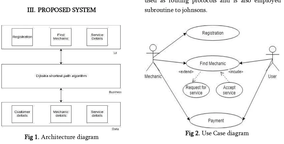
Fig 1. Architecture diagram
In Figure 1, The system architecture mainly contains layers with UI Business and Data layers. Main
algorithm used in the proposed system is Dijkstra’s
shortest path algorithm to find the nearby customers who are mapped to the nearby mechanic, after matching the mechanic to suitable customer the live location can be monitored in the user’s mobile . Data
such as mechanic details, customers details and service details are stored in firebase and will be retrieved on demand.
Maps API we have to add a Maps API key to Smartphone application. The key is free and can be used with any application that calls the Maps API, and it supports many users. Maps API key can be achieved from the Google APIs Console by providing application of signing certificate and its package name. The key is included in the application by adding an element AndroidManifest.xml file.
C. Dijkstra’s Algorithm:
Dijikstra’s algorithm is used for finding the shortest
path between the nodes. Example: Road networks.It assumes a single initial node and builds up to make
up a shortest path tree. Dijikstra’s algorithm is also
used as routing protocols and is also employed as subroutine to johnsons.
In a min-priority queue the time consumed is running the Android operating system. Google states that Android apps can be written using Kotlin,Java and c++ languages using the Android software development kit (SDK), while using other languages is also possible. All non-JVM languages, such as Go, javascript, C, C++ or assembly, need the help of JVM language code, that may be supplied by tools, likely with restricted API support. Some languages/programming tools allow cross-platform app support, i.e. for both Android.Third party tools, development environments and language support have also continued to evolve and expand since the initial SDK was released in 2008.
B. Google Map API
Google Maps are commonly used to determine the destination location, calculate distance and approximate time to reach a destination point from your current location. Basically, Google Maps have an extensive array of application program interfaces (APIs) that let you embed the great functionality and effectiveness of Google Maps into your Smartphone applications. Google gives by means of Google play a library for using Google Maps into Smartphones application. At present, Google Maps Android API V2 are available that provides improvements to the older API version. The Google Maplibrarygives com.google.android.gms.maps.MapFragment class unvisited nodes called the unvisited set.
2. Assign to every node a tentative distance value: set it to zero for our initial node and to infinity for all other nodes. Set the initial node as current.
3. For the current node, consider all of its unvisited neighbors and calculate their tentative distances through the current node. Compare the newly calculated tentative distance to the current assigned value and assign the smaller one. For example, if the current node A is marked with a distance of 6, and the edge connecting it with a neighbor B has length 2, then the distance to B through A will be 6 + 2 = 8. If B was previously marked with a distance greater than 8 then change it to 8. Otherwise, keep the current value.
4. When we are done considering all of the unvisited neighbors of the current node, mark the current node as visited and remove it from the unvisited set. A visited node will never be checked again. 5. If the destination node has been marked visited
(when planning a route between two specific nodes) or if the smallest tentative distance among the nodes in the unvisited set is infinity (when planning a complete traversal; occurs when there is no connection between the initial node and remaining unvisited nodes), then stop. The algorithm has finished.
6. Otherwise, select the unvisited node that is marked with the smallest tentative distance, set it as the new "current node", and go back to step 3.
IV.IMPLEMENTATION
The proposed system has two major divisions. One is the Mechanic portal and the other is the Customer Portal
A. Mechanic portal:
The mechanic portal allows the mechanic to initially register into the system and after logging in the application, the mechanic will be able to find any available customer looking for a service to be done. If the offer is accepted by a mechanic, location of the customer will be sent to mechanic and intimated to the customer also .
B. Customer portal:
The Customer portal mainly focuses on recording customer complaints and post it to nearby mechanics available in that locality and if the service request is accepted by the mechanic, routing will be carried over to the location.
C. Working:
The working starts from the customer’s portal where
a complaint or service request will be lodged for the vehicle and details of the service repair will be recorded and then stored. Furthermore, the details of the customer will be sent to the nearby mechanics in that locality. In the mechanic portal after initially registering into the application, a feed of customer complaints will be displayed and this feed will be
based on Dijikstra’s shortest path algorithm which
displays the nearest customer first and other customers in a cumulative manner. After selecting the suitable customer for service, Facilities like calling the customer will be enabled and finally the
mechanic will be routed to the customer’s location
through google maps. The proposed system will
overcome the difficulty of locating mechanic based on locality.
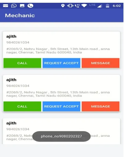
V. RESULT AND ANALYSIS
Fig 3 Mechanic route to customer
Fig 5 Mechanic login Portal
Fig 6 Customer Features
Fig 7 Employee Registration
VI.CONCLUSION
While the chances of a properly maintained vehicle experiencing a breakdown are slim, it is never a possibility to predict when the user may experience a vehicular breakdown. The Android application developed here promises to make the life of a vehicle owner that much easier, as even in the probability of a breakdown, the vehicle owner is assured of the fact that he has a solution to the problem within a few steps of entering details in his smart phone and save himself from a major setback in such an undesirable situation. The proposed system promises to act as a source of protection against the unpredictability of a vehicular breakdown and offers the owner of a particular some peace of mind in the event of
VII. FUTURE SCOPE
The goal of this project is to produce an interactive application for the Android marketplace. EMechanic Service is composed of two main components: a client-side application which will run on Android handsets, and a server-side application which will support and interact with various client-side features. The system is designed to provide, services provided by mechanics at various places, locations of all the service centers in the vicinity etc. The above proposed model is easy to implement considering the available technology infrastructure. The models are simple, secure and scalable. The proposed model is based on serial communication. Future scope for the project is scaling the system by making use of connectionless system.
VIII. REFERENCES
[1]. "Implementation of Cloud Messaging System Based on GCM Service". Computational and Information Sciences (ICCIS), 2013 Fifth International Conference. Penghui Li Transp. Manage. Coll., Dalian Maritime Univ., Dalian, China Yan Chen ; Taoying Li ; Renyuan Wang ; Junxiong Sun
[2]. "A public safety application of GPS-enabled smartphones and the android operating system"- Systems, Man and Cybernetics, 2009. SMC 2009. IEEE International Conference-Whipple, J.Inf. Syst. Eng. Dept., Southwest Res. Inst., San Antonio, TX, USA Arensman, W. ; Boler, M.S.
[3]. "Unified platform for the delivery of notifications to smartphones notification" Carpathian Control Conference (ICCC), 2012 13th International. Mojzisova, A. Inst. of Control & Informatization of Production Processes, Tech. Univ. of Kosice, Kosice, Slovakia Mojzis, M.
[4]. "An improvement of the shortest path algorithm based on Dijkstra algorithm "Computer and Automation Engineering (ICCAE), 2010 The 2nd International Conference on (Volume:2 ). Ji-xian Xiao Coll. of Sci., Hebei Polytech. Univ., Tangshan, China Fang-Ling Lu.
[5]. "Developing an Android based learning application for mobile devices", Telematics and Information Systems (EATIS), 2012 6th Euro American Conference, de Clunie, G.T.Fac. de Ing. de Sist., Computacionales, Univ. Tecnol. de Panama, Panama City, Panama Serrao, T. ; Monteiro Braz, J.R.- . Serr o, T. Rangel, N. Castillo, A. G mez, B. Rodr guez, . de Barraza, . Riley, J.
[6]. "Automobile Service Center Management System", International Journal of Scientific and Research Publications, Volume 4, Issue 3, March 2014 , Prof. Shilpa Chavan Saket Adhav, Rushikesh Gujar, Mayur Jadhav, Tushar Limbore (Padmabhooshan Vasantdada Patil Institute of Technology, Pune)
Cite this article as :
Ajith Kumaar. D, Balakrishnan, Sree Subha. S, Harin. K , "On Road Vehicle Service Finder", International Journal of Scientific Research in Computer Science, Engineering and Information Technology (IJSRCSEIT), ISSN : 2456-3307, Volume 5 Issue 2, pp. 929-936, March-April 2019.