CSEIT183557 | Received : 10 May 2018 | Accepted : 25 May 2018 | May-June-2018 [ (3)5 :310-315 ]
© 2018 IJSRCSEIT | Volume 3 | Issue 5 | ISSN : 2456-3307
Google Maps with Visual Positioning System
Samrudhi R Kaware
Student, Department of Computer Engineering, Ahmednagar , Maharashtra, India
ABSTRACT
The emerging trends that is Artificial Intelligence (AI) and machine learning Google have developed a navigation tool by which the location near by our route is been visualized .Many of the new features are based on the AI and other future technologies as Google aims to make these applications more efficient and productive for users. For instance, Google Maps is using Augmented Reality (AR) technology to help guide you to your destination. When you pull up direction on Google Maps, you can look through the camera and get turn-by-turn directions while viewing the actual street. The app will also orient you and verify your position using local landmarks such as buildings and shops viewed through the camera. Google calls the technology VPS, or visual positioning system.
Keywords: DOMAIN : DATA MINING: Data virtualization, Augmented reality, Artificial Intelligence, machine learning, NLP.
I.
INTRODUCTION
History
Google Maps first started as a C++ program designed by two Danish brothers, Lars and Jens Eilstrup Rasmussen, at the Sydney-based company Where 2 Technologies. In October 2004, the company was acquired by Google, which converted it into a web application. After additional acquisitions of a geospatial data visualization company and a real time traffic analyzer, Google Maps was launched in February 2005. The service's front end utilizes JavaScript, XML, and Ajax. Google Maps offers an API that allows maps to be embedded on third-party websites, and offers a locator for urban businesses and other organizations in numerous countries around the world. Google Map Maker allowed users to collaboratively expand and update the service's mapping worldwide but was discontinued from March, 2017. However, crowd sourced contributions to Google Maps were not discontinued as the company announced those features will be transferred to Google Local Guides program.
Google Maps' satellite view is a "top-down" or "birds eye" view; most of the high-resolution imagery of cities is aerial photography taken from aircraft flying at 800 to 1,500 feet (240 to 460 m), while most other imagery is from satellites. Much of the available satellite imagery is no more than three years old and is updated on a regular basis. Google Maps uses a close variant of the Mercator projection, and therefore cannot accurately show areas around the poles.The current redesigned version of the desktop application was made available in 2013, alongside the "classic" (pre-2013) version. Google Maps for Android and iOS devices was released in September 2008 and features GPS turn-by-turn navigation along with dedicated parking assistance features. In August 2013, it was determined to be the world's most popular app for smartphones, with over 54% of global smartphone owners using it at least once.
II.
GOOGLE MAP PROJECTION
another. Methods for representing these features on paper are known as map projections.
Google Maps use a Spherical Normal (equatorial) variant of the Mercator projection for its map images. The Mercator map was developed in 1569 by Gerardus Mercator as a navigation tool based on a rectangular grid with parallel lines of latitude and longitude. The Mercator map was designed as an aid to navigators since straight lines on the Mercator projection are loxodromes or rhumb lines - representing lines of constant compass bearing - perfect for 'true' direction.
The Mercator projection exaggerates the size of areas far from the equator. For example, Greenland is presented as having roughly as much land area as Africa, when in fact Africa's area is approximately 14 times greater than Greenland. Google Maps cannot show the poles as the Mercator projects them at infinity. Instead it cuts off coverage at 85° north and south.
Google Maps use a Spherical Normal (equatorial) variant of the Mercator projection for its map images. The Mercator map was developed in 1569 by Gerardus Mercator as a navigation tool based on a rectangular grid with parallel lines of latitude and longitude. The Mercator map was designed as an aid to navigators since straight lines on the Mercator projection are loxo dromes or rhumb lines - representing lines of constant compass bearing - perfect for 'true' direction.
Google Maps and Street View parameters
Figure 1
The redesigned version's view with a fixed-zoom level of the small (Street or Satellite) overview that a user cannot zoom-in or out.
Figure 2
In Google Maps, URL parameters are sometimes data-driven in their limits and the user interface presented by the web may or may not reflect those limits. In particular, the zoom level (denoted by the z parameter) supported varies. In less populated regions, the supported zoom levels might stop at around 18. In earlier versions of the API, specifying these higher values might result in no image being displayed. In Western cities, the supported zoom level generally stops at about 20. In some isolated cases, the data supports up to 23 or greater, as in these elephants or this view of people at a well in Chad, Africa. Different versions of the API and web interfaces may or may not fully support these higher levels.
Figure 3
Google maps new visual positioning system fixes navigation. Aparna chennapragada introduced one of the best new features : visual guidance and visual positioning system in Google maps navigations. We’ve all had been delayed figuring out Google Maps Navigation before — ―am I going the right direction?‖ Google Maps can now use your camera to identify your surroundings, visually communicate your route right in front of your eyes!
Visual navigation
Figure 4
Tap a button to activate visual view and then just point your camera where you need to go to see relevant info. You will see your surroundings with an overlay of Maps information for nearby business, arrows pointing you in the direction you need to go, with a small map at the bottom to remind you where you are headed. This is a powerful addition to Google Maps and Street View.
Google’s even playing with the idea of putting a character on the screen as an augmented reality tour guide. In the demo, it was a little fox.
The concept of Visual Positioning System – VPS
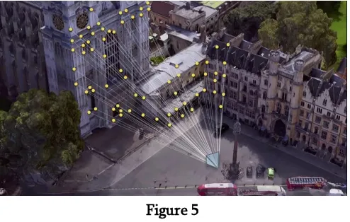
Figure 5
When your GPS is not enough, the new visual system in Google Maps can also use the newly coined Visual Positioning System (VPS) feature. The VPS uses your phone’s camera and Google’s extensive back-end data to analyze your surroundings to identify where you are with greater accuracy.
A few members of our team members are already cheering about this. They live in densely populated urban areas with tall buildings and often complain of GPS drift and other hassles when navigating. The new visual systems are made just for people like them.
IV.
GOOGLE I/O 2018
Google Maps to Get AR Mode, Redesigned Explore Tab, Group Planning
New AR mode
Google announced a new augmented reality (AR) feature that will make its way to Maps - and it was one of the biggest crowd-pleasers for the thousands of attendees at the keynote. Meant to help users get walking directions, the feature overlays arrows, landmarks, maps, and possibly even an animated creature to show the way in a camera view that is displaying the actual environment around the users. It is essentially a Street View-powered navigation feature, using the camera instead of a 3D rendering. Google Maps' AR mode needs more than just GPS to operate properly, the company said, and uses something called VPS (or visual positional system) to visually identify landmarks around the user using computer vision.
Figure 6
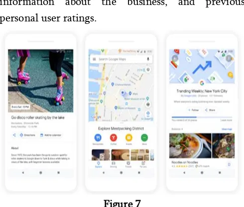
New Explore tab
With a revamped Explore tab, users can view every place of interest nearby their location. The tab will now show activities, restaurants, coffee shops, events, and recommendations from popular lists like Foodie Lists to help you find the best restaurants based on what local guides and experts are saying.
Matching venues
Using the power of machine learning and data that Google Maps has gathered on you, the service will recommend what percentage of a match a selected food or drink venue is to your preferences. This will be based on factors including places you have visited
before, preferences you have shared with Maps, information about the business, and previous personal user ratings.
Figure 7
Group planning
Adding the essence of a social network, Google Maps will soon incorporate a new group planning feature that lets users create shareable shortlists making it easier to coordinate plans with friends and family. You can long press on places and your group mates can vote to keep it in or out. Once finalized, Google Maps already has functionality to let you make a reservation as well as book a cab ride to the venue.
V.
DIFFERENCE BETWEEN GPS AND VPS
VPS is a related feature, combining the live camera view with Google's data trove to get a better sense of position than possible with just GPS. The technology could be especially useful in dense urban areas where GPS is often blocked by skyscrapers.
Global Positioning System : GPS
GPS satellites continuously transmit data about their current time and position. A GPS receiver monitors multiple satellites and solves equations to determine the precise position of the receiver and its deviation from true time. At a minimum, four satellites must be in view of the receiver for it to compute four unknown quantities (three position coordinates and clock deviation from satellite time).
Visual Positioning System : VPS
An indoor positioning system (IPS) is a system to locate objects or people inside a building using radio waves, magnetic fields, acoustic signals, or other sensory information collected by mobile devices. There are several commercial systems on the market, but there is no standard for an IPS system. Due to the signal attenuation caused by construction materials, the satellite based Global Positioning System (GPS) loses significant power indoors affecting the required coverage for receivers by at least four satellites.
In addition, the multiple reflections at surfaces cause multi-path propagation serving for uncontrollable errors. These very same effects are degrading all known solutions for indoor locating which uses electromagnetic waves from indoor transmitters to indoor receivers. A bundle of physical and mathematical methods are applied to compensate for these problems. Promising direction radiofrequency positioning error correction opened by the use of alternative sources of navigational information, such as inertial measurement unit (IMU), monocular camera Simultaneous localization and mapping (SLAM) and WiFi SLAM. Integration of data from various navigation systems with different physical principles can increase the accuracy and robustness of the overall solution.
VI.
CONCLUSION
A visual positioning system for indoor locations with associated content is provided herein. The system has a map creator and a viewer. The map creator maps
the indoor location by acquiring plans thereof, detects paths through the location and associates with the paths frames relating to objects and views of the paths. The viewer allows a user to orient in the indoor location by locating the user with respect to a path. The viewer enhances GPS/WIFI/3G data by matching user-captured images with the frames, and then interactively displaying the user data from the mapped paths with respect to user queries.
VII.
REFERENCES
[1]. Perez, Sarah. "Google to shut down Map Maker, its crowd sourced map editing tool | TechCrunch". Archived from the original on August 11, 2017. Retrieved June 23, 2017. [2]. Meyer, Robinson (June 27, 2016). "Google's
Satellite Map Gets a 700-Trillion-Pixel Makeover". The Atlantic. Archived from the original on June 27, 2016. Retrieved June 27, 2016.
[3]. Heater, Brian. "Google Maps picks up mapping analytics and visualization startup Urban Engines". TechCrunch. Archived from the original on September 17, 2016. Retrieved September 16, 2016.
[4]. Gartenberg, Chaim (August 29, 2017). "Google Maps will now help you find parking". The Verge. Vox Media. Archived from the original on December 8, 2017. Retrieved December 7, 2017.
[5]. Ghoshal, Abhimanyu (December 5, 2017). "Google Maps' new two-wheeler mode shows faster routes for beating traffic on your bike". The Next Web. Archived from the original on December 6, 2017. Retrieved December 7, 2017.
[7]. Qiu, Chen; Mutka, Matt (2017). "Silent whistle: Effective indoor positioning with assistance from acoustic sensing on smartphones". IEEE International Symposium on A World of Wireless, Mobile and Multimedia Networks. doi:10.1109/WoWMoM.2017.7974312.
[8]. Wan Mohd, Yaakob Wan Bejuri; Murtadha Mohamad, Mohd (2014). "Wireless LAN/FM Radio-based Robust Mobile Indoor Positioning: An Initial Outcome" (PDF). International Journal of Software Engineering and Its Applications. 8 (2): 313–324.
[9]. Kanakarajan, Pavithra (May 22, 2015). "Map Maker will be temporarily unavailable for editing starting May 12, 2015". Google Product Forums. Retrieved May 10, 2015
[10]. Qiu, C.; Mutka, M. W. (2015-10-01). "AirLoc: Mobile Robots Assisted Indoor Localization". 2015 IEEE 12th International Conference on Mobile Ad Hoc and Sensor Systems (MASS): 407–415. doi:10.1109/MASS.2015.10. ISBN 978-1-4673-9101-6.
[11]. Arrington, Michael. "Google Redefines GPS Navigation Landscape: Google Maps Navigation For Android 2.0". TechCrunch.com. Retrieved 5 February 2013.
[12]. "Google Maps for mobile announce Navigation Beta for Android 2.0 – GSMArena.com news". GSMArena.com. Retrieved 5 February 2013. [13]. Schroeder, Stan. "Google Maps Navigation
Navigation Now Works in Canada and Most of Europe". Mashable.com. Retrieved 5 February 2013.
[14]. Lam, Brian. "Google Maps Navigation: A Free, Ass-Kicking, Turn-by-Turn Mobile App". Gizmodo.com. Retrieved 5 February 2013. [15]. Nosowitz, Dan. "Google Maps Crowdsources
Traffic by Measuring Your Miserable Commute". Gizmodo.com. Retrieved 5 February 2013.
[16]. Wilson, Randy (December 8, 2009). "Google
LatLong: Changing your perspective". Google-latlong.blogspot.com. Archived from the