Available Online at www.ijcsmc.com
International Journal of Computer Science and Mobile Computing
A Monthly Journal of Computer Science and Information Technology
ISSN 2320–088X
IMPACT FACTOR: 6.017
IJCSMC, Vol. 7, Issue. 3, March 2018, pg.51 – 67
Self-Adaptive Traffic Recommendation System
Beijing City as a Case Study
Aiman Abu Samra
1, Ibrahim Al-Sharif
2, Ahmed Skaik
3, Fatma El-Rebai
4,
Haneen El-Talli
5, Mohammed Shbair
6Computer Engineering Department, Islamic University of Gaza, Gaza, Palestine
[email protected], [email protected], [email protected], [email protected], [email protected], [email protected]
Abstract— Due to the widespread use of smart phones, location-based services (LBS) has become important in all aspects of human’s life. LBS offer many advantages to the mobile users to retrieve information about their location. Some LBS services use the smartphone’s location and service provider information to offer directions, targeted recommendations, or other location-specific information to the user. In this paper we proposed a novel location-based method that provides a traffic recommendation based on community contributed and collaborated movement history. Proposed model is designed to perform some computational processes on the data collected from real users and decide which path is better to follow to reach the desired destination from a given source location. Proposed method mine places and paths between places from the raw data and analyse these data to provide a recommendation to reach a specific target location. Proposed method is adaptable for new movement information. We use a dataset for Beijing city as a case study to proof our proposed method.
Keywords— Location Based Service (LBS), traffic recommendation system, trajectory, clustering, learning algorithm, self-adapting.
I. INTRODUCTION
The Location based Services (LBS) offer many advantages to the mobile users to retrieve the information about their current location and process that data to get more useful information nearby their location. With the help of A-GPS in phones, LBS can be implemented on Android based smart phones to provide these value-added services: advising clients of current traffic conditions, providing routing information, help people find nearby locations.
Recommending trajectory requires analysing big amount of data to mine the fastest trajectory to from specific location to the target location, many algorithms have been presented to analyse this type of data which consists of many points in each trajectory. Trajectory mining has many challenges, for example the different sizes of the trajectories make the similarity calculation harder, also the fact of that the one trajectory may embed many sub-trajectories complicate the analysis more and more.
There are many trajectory mining methods: clustering, classification, pattern mining, outlier detection and prediction, both clustering and classification considered as main methods [5].
At present, the trajectory clustering approaches include two types [6]: the first cluster the trajectory data based on the similarity of the full sequences. In other words, they take the whole trajectory as a unit to cluster the trajectory data. Those approaches have good effects on the clustering for the simple trajectories, however, they have negative effects for complex trajectories due to the fact they ignore the local detail sequences. The second type cluster the trajectory data based on the similarity of the sub-sequences. This means that the whole complex trajectory sequence is divided into several segments, which can be clustered with one segment as a unit. The second approaches have the ability to recognize the local features of complex trajectories.
The rest of this paper is organized as follow: The next section introduces the related work. Section three describe the motivation and problem statement. The research methodology detailed in section four. Section five listing the results while section six discuss the evaluation. Finally, section seven concludes the findings.
II. RELATEDWORK
Systems that provide real time information to assist in planning routes and choosing the most appropriate paths are essential to make transport more effective.
As an alternative solution to problems related to mobility in cities, there are the so-called Intelligent Transportation Systems (ITS) which include the Route Recommendation Systems (RRS) and methodologies for congestion prediction that combine Information and Communication Technology (ICT) with Artificial Intelligence (AI) technology to improve the quality of transport systems [7].
A wide variety of ITS tools have played important roles in the effectiveness of transport. These systems provide information related to traffic, influencing in various aspects of transport in relation to urban mobility. Most of these ITS tools uses static information aided by the traffic infrastructure integrated technologies. Pires et al [7] introduced ACORoute, they propose the use of pheromone-based communication for building an ITS that offers information about real time traffic flow, taking into account the mobility of vehicles and passengers and the traffic dynamics.
The operating principle of their strategy occurs with vehicles that mark their path by dropping digital points which are perceived by all the vehicles that travel in the environment. This mechanism is used to allow the calculation of a route that avoids heavy traffic.
LBS is a concept that can be vastly utilized. LBS can be applied in public and private industry, such as emergency service in medical [8]; tracking industry [9]; navigation industry, such as digital map; payment; tourism guidance [10] and so on. It can be particularly powerful when combined with other user profile information to offer personalized and location sensitive responses to customers, this form is called the context aware system. Furthermore, the information recommendation systems based on personal interests is currently an active research area, keeping in mind that many applications have been recommended and produced by different authors and developers during last decade to effectively and efficiently control the location based recommendation system by giving different solutions. Maruyama et al.[11] propose a personal navigation system called P-Tour for tourism. Islamabad City Guide is one of the city guides. It uses static maps and pictures to show the places [12]. Byon et al. used a multi criteria shortest path algorithm which considers scenic zones, slope and crime ratio in the cost function [13]. Mckercher and Lau attempted to identify the movement patterns and styles of tourists within an urban destination [14].
Moreover, many vendors provide some geographic information services. Such as Google Maps show search results on a map interface, Yahoo! Local Maps, Google Earth and Microsoft Virtual Earth allow users to explore richer geographical contents.
same direction [16]. Closest-Pair Distance for example assumes the same length of the trajectories and considers the similarity as distance between points in the two trajectories [17].
In this paper, we show that the community contributed and collaborated database can tackle these issues and provide an efficacious solution to automatic locations analysis.
III.MOTIVATIONANDPROBLEMSTATEMENT
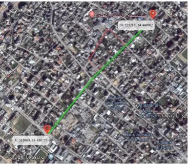
Many of LBS applications providing information about locations and places and offering different kind of tracking mechanisms. However, unfortunately the proper GPS services is not completely supported in Gaza Strip, which could bring an imprecise location, places and directions detection. For instance, we attempt to acquire the best path from Al-Azhar square to Lababiddi square using google map application installed in Android mobile, and incorrectly it gets wrong directions for some particular streets. Fig 1 shows the right path (green), and the wrong google targeted path (red), since the red path is a one-way street path.
Fig. 1 Longer path suggested by google
Different problems are arising while users attempt to use LBS systems which we can address and avoid by developing the proposed system.
The user can use this application obviously for different purposes like searching a location, calculate distance between two locations and acquiring the best path between two locations considering a couple of circumstances like (weather status, traffic jam, and accurate street directions),
The approach in this paper is to develop an application based on a mobile device running the Google Android platform. The device used is 2.5 G technology. Definitely this is the key point of our work, where users unluckily couldn’t be connected to the internet all the time. Furthermore, our intent and main purpose of this project is to come up with an Android application which efficiently helps people to create a commutative and cumulative data warehouse for their movements and activities. And the system will manage and manipulate this data along with regular intelligent algorithms to be available on demand.
Moreover, the system will produce a best-path recommendation guide, and helps the user navigate the history of their saved activities.
IV.PROPOSEDMETHOD
In this section we describe the proposed method which gives path recommendation based on users' collaborative GPS information.
Fig. 2 The main steps of the proposed method
GPS information collected in a way that it may be for one hour time, one day or even one week. To be able to analyse these information we segment each path to chunks based on a criterion. Criterion may be Time or behaviour to segment a set of consecutive GPS location points.
In the proposed method we mainly consider the path direction change (bearing) as the core criterion to detect turning points which form the turning places, these turning places are used to segment paths.
A. Mining Turning Points
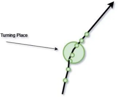
Turning point is a point where the direction of a path changes relative to the earth north direction, while turning place is an area of path/s turning points. Turning place may be a crossroad, an intersection, a curve or any direction change location. To extract turning points we used bearing concept, where the bearing of a point is a clockwise direction to the north of the earth from the earth center. To detect the direction of a path in specific scope (between P2 and P1) we calculate the difference bearing between current point (P2) and previous point (P1). See Fig. 3.
Bearing between two points =
θ = atan2 (sin Δλ ⋅ cos φ2 , cos φ1 ⋅ sin φ2 − sin φ1 ⋅ cos φ2 ⋅ cos Δλ ) … (1)[18]
Where:
φ1, λ1 is the start point, φ2, λ2 the end point (Δλ is the difference in longitude)
Fig. 3 Bearing of GPS points
To detect the possible change in direction like in fig. 4, we calculate the difference in direction between the current direction and the previous direction.
Previous direction (pd) = Bearing (P2) - Bearing (P1) .…….(2)
Current direction (cd) = Bearing (P3) - Bearing (P2) ……..(3)
Fig. 4 Consecutive points with change in direction
If the change in direction is greater than some threshold ɵ, then we consider that there is a turning point. In fact the real change in direction happens in somewhere between the current point and the previous point, We choose the previous point as the turning point, because we don’t need to generate new points. Fig. 5 shows example cases of detecting turning points in the same place but from different taxis.
Fig. 5 Different cases of detecting turning point P2
To prevent extracting unnecessary points for the same curve, we check the next point only if its distance with the current point is more than EPS, this check also eliminates the stay points problem, as in fig. 6.
We eliminate the noise points by checking the speed, if the speed is not reasonable, then we neglect that point. Because noise point jumps suddenly far away from the real path points, as in Fig. 7.
If (d > EPS) and v < 2000 m/s and (cid > ɵ) then the previous point is turning point. ... (5)
Fig. 7 Sample of noise points
B. Mining Turning Places
Many paths may pass through the same place with different points values closed to each other. These points are considered as one turning place with specific radius (cluster). We applied unsupervised learning algorithm to cluster these points in one place. Density-based clustering algorithm (DBSCAN) is applied to all extracted turning points to produce turning places [19].
Density-based clustering algorithm is considered as one model of various clustering analysis models It defines clusters as connected dense regions depending on two important parameters, first is (σ) which represents the radius around the point to search for the number of neighbourhoods. The second is (ξ) which represents the minimum number of neighbourhood points required to consider this point as a part of a cluster. Choosing these two parameters majorly affects the clustering quality [20].
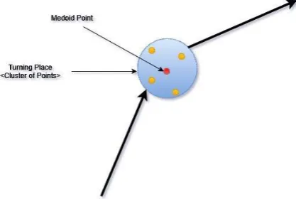
In most applications (σ) and (ξ) estimation are considered as the main disadvantage of DBSCAN algorithm. Fortunately, in our application (σ) and (ξ) are two advantages because even one turning point should be consider as a cluster not noise (ξ) =1, also we can estimate directly what is (σ). For every cluster we choose medoid point as cluster representative point. (medoid is one of the points not a new point) as in Fig. 8.
Fig. 8 Turning place with representative point
Segmenting all paths in the dataset is based on passing through the turning place (cluster of turning points). Cluster radius is the maximum distance between cluster points and the representative point.
C. Segmenting Paths:
Fig. 9 More than one point pass through the place
In case if the cluster is only one point and the cluster radius is zero, or in case if the cluster radius less than (σ), we compare the distance with (σ). Another case if two or more consecutive points of the path are located in the cluster radius, this produces a segment from turning the place to itself. So, while segmenting a path, if the current turning place is the same as the previous one, then this place will be neglected.
If current place (cp) ≠ previous place (pp) and d<= max(cluster radius (cr), EPS) then the current point is considered as segment point. …….. (6)
One last note regarding to segmentation is that, because we have a huge number of representative points, we don’t compare every point in the path to all representative points. Instead we first, check the turning points of the path, then compare each turning point to all representative points to segment the path.
D. Recommendation
To find the optimal path in a specific time for a specific user, we enhance the A* algorithm [21]. As we have a huge number of places and edges in our map, so we can’t use any algorithm that visits all places (nodes), because this will cause low performance and consume more memory.
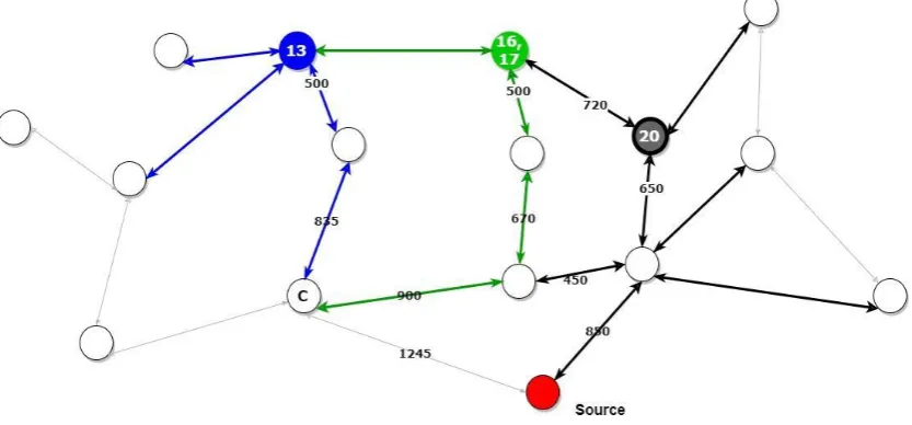
We need to check only places and paths in a scoped area, to achieve that we start, like A*, from the target places which prepare the next possible nodes. The A* then calculates the direct distance to the source node, then takes the node with minimum distance and repeat the previous steps until reach to the source node. But this way is not appreciate in our case, because there is no guarantee that the closest point to the source will lead to the shortest path. Noting that we don’t use the Cartesian distance here because we have to consider the earth curve. Fig. 10 shows that the path with weight 1200 leads to the shortest path while the paths with weight 655 and 1000 don’t.
Fig. 10 First iteration of the search method
at the end of the third step of the iteration we calculate the direct distance to the source node from each place resulting from the first iteration then choose the most closest three nodes. As in fig. 10, we have 11 leaf nodes, three of them have the minimum direct distance to the source node: node13, node17 and node 20 (node16 and node17 are the same node). In the next iteration we neglect the other 8 nodes and repeat the first iteration procedure in the next iteration and add children of the selected three nodes, and so on until find the source. In the second iteration step2 one of the paths reaches the source before other ones, the two other paths reaches node (c) and still need more one movement to reach the source. See Fig. 11.
The stop criterion of this method is reaching the source node from all paths or reach a leaf node which doesn’t lead to source from all/some paths. If the new leaf nodes diverge from the source in three iterations then there is no segment leads to the target source node.
Fig. 11 The second iteration of the search method
The proposed algorithm is scripted in the following pseudocode. At first call segment is equal null,
After getting the tree of possible paths, calculate the time-based shortest path.
Tree.addRoot(destination)
getOptimalPath (source, destination, segment) While(segment.start != source)
//Get all segments which end with the destination temp1= getConnectedSegments(destination) step1 += temp1
Tree.add(temp1)
//Get all segments which end with start of every segment in step1 list // For each segment segment1 in step1
While(segment1:step1 != source)
temp2 = getConnectedSegments(segment1.start) step2 += temp2
Tree.add(temp2)
//Get all segments which end with start of every segment in step2 list // For each segment segment2 in step2
While(segment2:step2 != source)
temp3 = getConnectedSegments(segment2.start)
step3 += temp3 Tree.add(temp3)
//Get the three segments which have the minimum cost and direct distance to the source node closer= getThreeMinimum(step3)
//Recursion call for every segment in closer segments list foreach close_segment in closer
return getOptimalPath (source, close_segment.start, close_segment)
E. Adapting
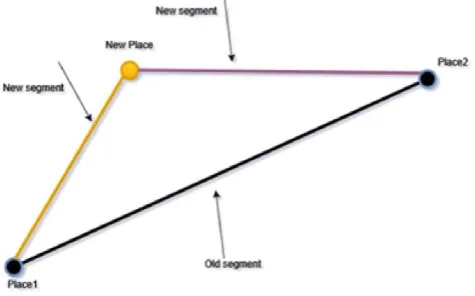
In this section we show how the proposed algorithm adapt/update the paths segmentation upon receiving new path information from users. Since our algorithm based completely on users information collaboration, it should be adapted according to any new information in continuous manner. When new path information uploaded to the server from any user, the proposed algorithm detects all turning points in the new path, classify each one to one of the existing clusters, update the cluster information and add the path segments information like: time, date and weather to the system.
If even one of the new turning points couldn’t be classified to any existing cluster, we consider it as new cluster. After adding a new turning place as a new cluster, we check if this new turning place holds updates to any of the existing segments, we check if the new turning place splits one or more of the existing segments.
Fig. 13 Case of need to update the old segment/s
V. DATASETANDCHARACTERISTICS
Microsoft T-Drive trajectory dataset contains a one-week trajectories of 10,357 taxis in Beijing, with 15 million points and total distance of 9 million kilometres [22], [23]. We used this dataset to prove our proposed algorithm, but it doesn’t contain any information about the weather state.
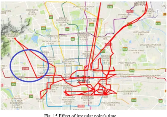
Data format is show in Fig. 14 consist of taxi id, date time, longitude and latitude. Time interval between consecutive points is irregular and rate from few seconds to half hour. Most points have intervals from 1 minute or 5 minutes as Microsoft shows. Fig. 15 is a Microsoft graph for intervals between consecutive points.
Irregular time periods of points, causes jumps over the roads, see Fig. 15.
Fig. 15 Effect of irregular point's time
Another characteristic of this dataset is existence of noise points which cause confusion and far jumps in the path provided from the taxi, see Fig. 16. Noise points are detected and eliminated from our calculations. We will show that when explaining turning points. Last thing we toke in our consideration is the stop points which occur when the taxi stops for a while in the same location or around the same location. We eliminated this problem and didn’t consider the time of stop points in the time of the path.
Fig. 16 Sample of the noise points
VI.EXPERIMENTS AND RESULTS
A. Mobile Application and Web Services
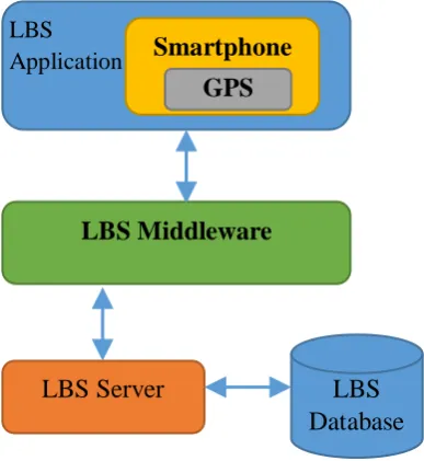
Sensor
LBS Middleware
LBS Server
LBS
Database
Fig. 17 components of LBS system and interaction
In the data collection mode, we used the GPS service to capture the current location every 10 seconds or 1 meter and store it on the local mobile database. Each captured location denoted by STEP node. The STEP node contains the following information: sequence number, latitude, longitude, weather status and the exact date/time. Each list of steps is linked to the user used during the capturing process.
Using the broadcast receiver, our application notified that the wireless communication to the internet is established. Once the mobile have the access to the internet, it starts pushing all the captured information other than the current trip to the server through a web service. This information prepared to be used by the backend algorithm service to classify the roads and to estimate the time required for each piece of the road.
In the testing mode, the user selects the source and destination locations on the map, then the mobile asks the backend server for the recommendation. The server should send back the best path taking into consideration all factors such as distance, traffic conjunction, weather and the user’s experiences. Then the mobile application draws the recommended path on the map and print out the estimated time required for this recommended path.
The application could not be run without authentication, it asks the client to enter his username and password for the first time. All information gathered from any given mobile will be linked to the signed in user.
Web service is one of the most appropriate tool to share the information between two or more parties. It also makes easy to integrate the application with any endpoint regardless of platform. We have employed the web service to facilitate the communication between all parties in both training and testing modes.
In training mode, it is used to collect the data from the mobile application, by capturing the location in a timely manner and send all this information to the server to be stored in the database. The mobile application can use the web service to push all information stored in the local database to the central database.
This information will include sequence number, latitude, longitude, weather status and the exact date/time along with the user name collected from. The server should use this information during the estimation process.
In testing mode, the user should be able to ask for the recommendation on a given Source-Destination trip. All what is required from the mobile user, is to select the source and destination locations after then the mobile will send a request to the server through the web service to ask for the recommended path. The server will respond with a list of steps (geographical point) to be followed with the estimated time for this trip.
B. Results
Fig. 18 Extracted (Mined) turning place with radius about 11m
While Fig. 19 shows a turning place (cluster of turning points) which have 87 points and radius of 111 meters .The difference between clusters in radius and number of points is due to the density of the points provided in these places, clusters information like radius and number of points are updated during the time since users send their paths information continuously.
Fig. 19 Extracted place with radius of 111 meters
Fig. 20 Path of taxi number 89
Fig. 21 One day movements of the taxi 89
Fig. 22 Segmentation of the one day movements of taxi 89
In the fig. 22 we may note that there is something like missing segment which located below in the map, but because we deal with a part of the taxi data which happens in 2008-02-03, we cut the actual behaviour of the taxi and since there is no turning place found from the starting point to the next turning place, our algorithm neglect this part, see in Fig. 23 snap of the actual data 4 minutes before 2008-02-03 start.
Fig. 23 Movements information between two days
Fig. 25 Result of the recommendation process
● Segment 1: 1499.31 meters with average time of 3.15 minutes,
● Segment 2: 6068.67 meters with average time of 14.016666 minutes
● Segment 3: 1473.51 meters with average time of 6.1666665 minutes
● Segment 4: 2625.29 meters with average time of 13.95 minutes
● Segment 5: 2896.30 meters with average time of 6.1666665 minutes
● Segment 6: 1246.36 meters with average time of 3.8833334 minutes
● Segment 7: 1137.61 meters with average time of 6.15 minutes
● Segment 8: 285.64 meters with average time of 3.8833334 minutes
● Segment 9: 201.11 meters with average time of 3.3666666 minutes
The first look to the results shows that the number of segments is 8 not 9, but if you zoom in the map we find the last segment which appear in Fig. 26.
VII. CONCLUSIONANDFUTUREWORK
In this paper we proposed a novel location-based method that provides a traffic recommendation based on community contributed and collaborated movement history. Proposed model is designed to perform some computational processes on the data collected from real users and decide which path is better to follow to reach the desired destination from a given source location. Proposed method mine places and paths between places from the raw data and analyse these data to provide a recommendation to reach a specific target location. Proposed method is adaptable for new movement information. We use a dataset for Beijing city as a case study to proof our proposed method. We applied the proposed method one week period on 150 taxi paths information.
R
EFERENCES
[1] Zheng, Yu, and Xiaofang Zhou, eds. Computing with spatial trajectories. Springer Science & Business [2] Zheng, Yu. "Tutorial on location-based social networks." Proceedings of the 21st international conference
on World wide web, WWW. Vol. 12. No. 5. 2012. [3] Foursquare App., available: https://foursquare.com.
[4] Chris Pendleton, GeoLife 2.0: A Location-Based Social Network, available:
https://blogs.msdn.microsoft.com/virtualearth/2009/02/25/geolife-2-0-a-location-based-social-network/. [5] Mazimpaka, Jean Damascène, and Sabine Timpf. "Trajectory data mining: A review of methods and
applications," Journal of Spatial Information Science 2016.13 (2016): 61-99.
[6] Ma, L.B.; Li, P. "Spatio-temporal Trajectory Clustering Based on Automatic Subspace Clustering Algorithm" Geogr," Geo-Inf. Sci. 2014, 30, 7–11.
[7] Pires, C.S., de Aguiar, M.S. and Ferreira, P.R., 2015. Mobile ACORoute-Route Recommendation Based on Communication by Pheromones. Polibits, (51), pp.27-32.
[8] Ahn, Jinsoo, et al. "A study of healthcare system for patient location data based on lbs." Consumer Electronics, 2008. ICCE 2008. Digest of Technical Papers. International Conference on. IEEE, 2008.. [9] Marmasse, Natalia, and Chris Schmandt. "Safe & sound: a wireless leash." CHI'03 Extended Abstracts on
Human Factors in Computing Systems. ACM, 2003.
[10] Shuja ul Hassan, Irshad Ali, " Skardu City Tourist Guide - An Android Application".
[11] A. Maruyama, N. Shibata, Y.Murata, K. Yasumoto and M. Ito, “A Personal Tourism Navigation System to
Support Traveling Multiple Destinations with Time Restrictions,” In AINA 2004, pp. 18–22, 2004. [12] Umair Ahmed. Pakistan travel guide. Available: http://intellisenseglobal.com/, December 2014.
[13] Byon, Y.-J., Abdulhai, B., & Shalaby, A. (2010). Incorporating Scenic View, Slope, and Crime Rate into
Route Choices. Transportation Research Record: Journal of the Transportation Research Board, 2183,
94-102.
[14] Mckercher, Bob, and Gigi Lau. "Movement patterns of tourists within a destination." Tourism geographies 10.3 (2008): 355-374.
[15] J. Gil Lee, J. Han and K. Y. Whang. (2007). Trajectory clustering: a partition-and-group framework.
Proceedings of the 2007 ACM SIGMOD international conference on Management of data (SIGMOD '07),
(pp. 593-604).
[16] Rokach, Lior. "A survey of clustering algorithms." Data mining and knowledge discovery handbook. Springer, Boston, MA, 2009. 269-298.
[17] R. Agrawal, C. Faloutsos, and A. Swami. 1993. Efficient similarity search in sequence databases. Springer, 69-84.
[18] U.S. Army, Advanced Map and Aerial Photograph Reading, Headquarters, War Department, Washington,
D.C. (17 September 1941), pp. 24-25
[19] Ester, Martin, et al. "A density-based algorithm for discovering clusters in large spatial databases with noise." Kdd. Vol. 96. No. 34. 1996.
[20] Ibrahim Z. Alsharif, Wisam M. Ashour, Density-based Clustering Algorithms Parameters Estimation, 2015.
Technical report Available:
https://www.researchgate.net/publication/280920146_Density-based_Clustering_Algorithms_Parameters_Estimation