Kate Komal S1, Shaikh Javed Ahmed Husen2
P.G. Student, Department of E & Tc Engineering, SVPM’s COE College, Malegaon (Bk), Maharashtra, India1
Associate Professor, Department of E & Tc Engineering, SVPM’s COE College, Malegaon (Bk), Maharashtra, India2
ABSTRACT: There are reliant increments in vehicle numbers, vehicular traffic congestion, and carbon emissions that
cause significant issues around the world. These issues incorporate direct impacts on individuals' wellbeing, unfavourable monetary impacts, negative social effects, neighbourhood natural harm, and danger of disastrous worldwide environmental change. This paper describes the vehicle-to-vehicle-to-infrastructure (V2V2I) architecture, which is a hybrid of the vehicle-to-vehicle (V2V) and vehicle-to-infrastructure (V2I) architectures. The V2V2I architecture leverages the benefits of fast queries and responses from the V2I architecture, but with the advantage of a distributed architecture not having a single point-of-failure from the V2V architecture. The vehicles exchange messages related to traffic and road conditions, such as average speed on the road, road gradient, and surface condition. This information is used to build a fuel efficiency model of the routes, based on which the vehicles are prescribed to take more efficient routes. By routing vehicles more efficiently, the greenhouse emissions are diminished while also keeping up low traffic congestion levels.
KEYWORDS:Ad hoc networks, routing, vehicle communications, wireless LAN, road traffic.
I. INTRODUCTION
Using the V2V2I architecture over the V2V and V2I architectures provides many benefits, including reducing the bandwidth requirement for the roadway infrastructure (which includes the central server), and allowing fault tolerance in the event of a hardware failure of one of the centralized components. However, reducing the bandwidth needed by the central server means that less data is being transmitted to it. In fact, instead of every vehicle transmitting its speed and location to the central server (as is the case with the V2I architecture), in the V2V2I architecture, only one vehicle per zone will transmit speed and location data. Even though the Super Vehicle in each zone can run its own aggregation algorithm. Vehicular Ad-Hoc Networks (VANETs) are a one of a kind sort of MANET. A Mobile Ad-Hoc Network (MANET) is a network system of wireless nodes with no fixed infrastructure. Each of the nodes is mobile and the network must self-configure. Messages are routed dynamically and are passed by multi-hop communication. The medium is most usually broadband wireless networks (e.g. Wi-Fi), however could likewise be satellite, cellular or combination of all of these. In VANETs individual vehicles work as nodes. This network self-configures and messages are passed by multi-hop communication. VANETs for the most part utilize Wi-Fi for communication, despite the fact that research has also looked at cellular and satellite for underlying communications.
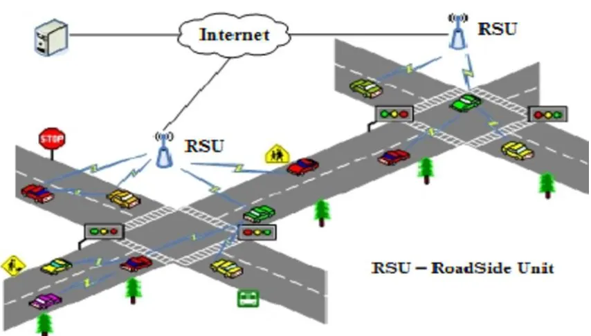
Fig. 1 VANET communications in an urban environment.
The V2I architecture enables vehicles to speak with some roadway framework to allow the speed and location of the vehicle to be transmitted to a central server. This server will keep up the speed and location of all vehicles and will aggregate this data for ITS applications, for example, deciding the quickest way from a vehicle’s current location to its destination or recognizing the location of an incident, among other applications. Taking the Los Angeles freeway system as an example, based on the California Department of Transportation’s Annual Average Daily Traffic in 2003, there could be conceivably up to 1 million vehicles in the freeway system at any given time. With that numerous vehicles transmitting speed and location information simultaneously, the amount of data that is transmitted to the central server will exceed current wired or wireless bandwidth limitations. Also, a central server has the limitation of being a single point-of-failure. The V2V architecture, then again, is very fault-tolerant because of the highly-distributed nature of the network. As vehicles come into the network, they become nodes that communicate with other different vehicles that are close in proximity to them. In any case, if a vehicle would like to know the speediest approach to get from its current location to its desired destination, there is a substantial amount of data that must be transmitted from other vehicles. Queries must be sent to vehicles along every single potential way from the source to the destination, and speed and location data must be received by the requesting vehicle so that it can precisely decide the quickest way based on the real-time data. This is a substantial amount of information which is not currently capable of being transmitted based on current wireless bandwidth limitations.
fuel funds of vehicles and decrease gas emissions. EcoTrec makes utilization of the Vehicular Ad-hoc Networks (VANET) both for gathering data from conveyed vehicles and to disseminate information in aid of the routing algorithm [1]. The algorithm calculates the fuel proficiency of different routes and then directs the vehicle to a fuel efficient route, while likewise avoiding flash crowding. Simulation based tests demonstrated that by utilizing EcoTrec, fuel emissions were fundamentally lessened, when contrasted with existing state-of-the art vehicular routing algorithms. Here showed that eco-friendly routes could very possibly be not the same as the shortest distance and shortest duration routes. By giving extra route options and the corresponding travel costs to drivers, they can consider the trade-off among the routes and make a choice with regard to which route to take based on their preferences and circumstances. Regardless of the possibility that the drivers take eco-friendly routes in some of their trips, it could add to the decreases of oil utilization and emissions, which are helpful to the drivers themselves and to the general public. There is the possibility that the fuel and emission saving benefits might attract much more drivers to the eco-routing navigation system. In the event that a large portion of the drivers begin to utilize the framework, it is conceivable that the eco-routes initially calculated may no longer be so as drivers are taking the same routes. This issue should be considered and tended in future work [2]. The proposed Time-Ants a VANET-based ant- colony optimization algorithm which utilizes historical traffic data to enhance traffic flows; this is a ne of a kind way to deal with managing traffic congestion. The simulation-based testing performed has compared Time-Ants against a number of other VANET-based routing techniques. Time-Ants outperformed the next best approach by 19% after four days of running the algorithm [3].
The receiving information on traffic over FM radio and examined existing flaws in navigation frameworks and methods for addressing them. They discussed issues such as gullibility errors where the driver follows the automotive navigation’s directions even when they don't make sense. Additionally it noted that drivers don't generally follow the advice of the navigation system. The paper suggests giving the driver a various decisions and indicating the advantages of each choice. This is a good idea as machines are not generally capable of judging the advantages of few ideas and different users will have different preferences, e.g. few drivers may dislike driving a specific roads[4]. The Vehicle to Vehicle (V2V) is a combination of three networks: an inter-vehicle network, an intra-vehicle network, and vehicular ad-hoc network. In view of this concept of three networks combined to form one, we define Vehicle-to-Vehicle as a large-scale distributed system for wireless communication and information exchange between surrounding vehicles according to agreed communication protocols and data interaction standards. It is an integrated network for supporting intelligent traffic management, intelligent information service, and intelligent vehicle control, representing a typical application of Internet of Things (IoT) technology in intelligent transportation system (ITS). To succeed in this emerging market, acquisition of core technologies and standards will be important. However, the integration of the V2V with different frameworks should be as important as the building of the V2V technologies themselves. As a result of this, the V2V will become an integral part of the largest Internet of Things (IoT) infrastructure by its completion[5].
III. METHODOLOGY
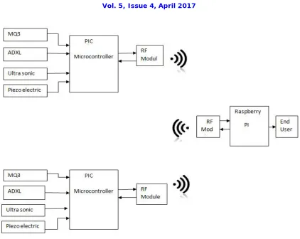
Fig. 2 Block Diagram of Transmitter and Receiver
Here PIC Microcontroller takes input from sensor and process on it. PIC devices are popular with both industrial developers and hobbyists due to their low cost, wide availability, large user base, extensive collection of application notes, availability of low cost or free development tools, serial programming, and re-programmable. This user takes all information from vehicles and based station i.e road condition road gradient, traffic information, normal speed on the road.
MQ2 gas sensor
In order to provide high accuracy gas sensor MQ-2 has been used. MQ-2 Semiconductor Sensor for Combustible Gas Sensitive material of MQ-2gas sensor is SnO 2, which with lower conductivity in clean air. MQ-2 gas sensor has high sensitivity to Methane, Propane and Butane and could be used to detect both Methane and Propane. The sensor could be used to detect different combustible gas especially Methane, it is with low cost and suitable for different application. Main application is to detect the pollution using MQ2 Gas Sensor.
Vibration sensor
Ultra sonic sensor
The Ultrasonic Sensor sends out a high-frequency sound pulse and then times how long it takes for the echo of the sound to reflect back. The sensor has 2 openings on its front. One opening transmits ultrasonic waves, (like a tiny speaker), the other receives them, (like a tiny microphone). The speed of sound is approximately 341 meters (1100 feet) per second in air. The ultrasonic sensor utilizes this information along with the time difference between sending and receiving the sound pulse to determine the distance to an object.
PIC Microcontroller 18F4520:
The hardware abilities of PIC devices range from 6-pin SMD, 8-pin DIP chips up to 100-pin SMD chips, with discrete I/O pins, ADC and DAC modules, and communications ports such as UART, I2C, CAN, and even USB. Low-power and high-speed variations exist for many types. The manufacturer supplies computer software for development known as MPLAB, assemblers and C/C++ compilers, and programmer/debugger hardware under the MPLAB and PICK it series.
Specification:
40-pin Low Power Microcontroller. Flash Program Memory: 32 kbytes. EEPROM Data Memory: 256 bytes. SRAM Data Memory: 1536 bytes. I/O Pins: 36.
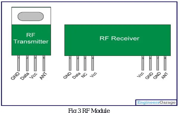
RF Module
Raspberry-Pi-Technology
The raspberry pi comes in two models, they are model A and model B. The main difference between model A and model B is USB port. Model A board will consume less power and that does not include an Ethernet port. In any case, the model B board incorporates an Ethernet port and designed in china. The raspberry pi comes with a set of open source technologies, i.e. communication and multimedia web technologies.
Fig.4 Raspberry Pi
The raspberry pi board includes a program memory (RAM), processor and graphics chip, CPU, GPU, Ethernet port, GPIO pins, Xbee socket, UART, power source connector. And various interfaces for other external devices. It also requires mass storage, for that we utilize an SD flash memory card. So that raspberry pi board will boot from this SD card similarly as a PC boots up into windows from its hard disk. Fundamental hardware specifications of raspberry pi board mainly include SD card containing Linux OS, US keyboard, monitor, power supply and video cable. Optional hardware specifications include USB mouse, powered USB hub, case, internet connection, the Model A or B: USB Wi-Fi adaptor is utilized and internet connection to Model B is LAN cable.
IV. V2V2I ARCHITECTURE
However, a closure with the V2I architecture is that it contains a single point of failure, which means that if the central server fails or the connection to the server fails, there is no way to retrieve any information. In addition, there are many details that need to be obtained from the server when all vehicles are sending speed and position data, and require the fastest routes (or other information). The V2V2I architecture attempts to reduce these constraints by exploiting the advantages of V2V and V2I structures.
V2V2I architecture, the system transport network is divided into zones, each of which consists of one or more edges. The zones are pre-designed so that each vehicle as well as the central server knows which edges are in which sectors. Every area has a vehicle, said excellent vehicle, which is responsible for speed data speed communication to the central server, and also transmits this information to Super vehicles in adjacent areas. The amplitude of the area should be small enough for two vehicles in the remote pockets between them within the area can now talk to each other. This is necessary if any of these vehicles are Super Vehicle Requirements for data of all vehicles in the area. In addition, the areas need to be small enough so super-adjacent vehicles to communicate. This architecture allows the return to a V2V structure in case of a failure with centralized components. Most vehicles within an area send their speed and position via a Super Vehicle Wireless Link in the area. Super total carries these data and sends the added speed and position to the central server. Note that the Super vehicle does not need to send just one speed and position to the central server. The information sent to the server, and the frequency of the data sent, can be arranged by considering the application that requires the data. The aggregation algorithm used determines the accuracy of data in the central server over the V2I architecture, which means that each vehicle is transmitting its speed and position to the central server.
V. CONCLUSION
The new integrated communication technologies in the automotive sector provide an opportunity to better care for people injured in traffic accidents, reducing the response times of emergency services and increasing the information they have about the accident. Incident just before the start of the savings process. To this end, we have designed and implemented a prototype for the automatic notification of accidents and assistance based on V2V and V2I communications. However, the effectiveness of this technology can be improved with the support of intelligent systems that can automate the decision-making process associated with an accident. Existing mining activity focused more on traffic accidents is based on the data set in which a pre-processing and a very limited transformation were carried out.
REFERENCES
[1]Chiranjib Sur, Sanjeev Sharma, AnupamShukla, “Multi-Objective Adaptive Intelligent Water Drops Algorithm for Optimization & Vehicle Guidance in Road Graph Network”, 2013 IEEE.
[2]Ove Andersen, Christian S. Jensen, KristianTorp, Bin YangEcoTour, “Reducing the Environmental Footprint of Vehicles Using Eco-Routes”, 2013 IEEE 14th International Conference on Mobile Data Management.
[3]Ronan Doolan, Gabriel-MiroMuntean, “VANET-enabled Eco-friendly Road Characteristics-aware Routing for Vehicular Traffic”, IEEE 2013. [4]F. Schaub, M. Hipp, F. Kargl, and M. Weber, “On credibility improvements for automotive navigation systems,” Pers. Ubiquitous Comput., vol. 17, no. 5, pp. 803–813, Apr. 2012.