Structural Diversity of Woody Species in the Senegalese
Semi-Arid Zone—Ferlo
Ousmane Ndiaye1, Aly Diallo1, Stephen A. Wood2, Aliou Guisse1,3*
1
Department of Plant Biology, Faculty of Science and Technology, Université Cheikh Anta Diop, Dakar, Sénégal; 2Department of Ecology, Evolution, and Environmental Biology, Columbia University, New York, USA; 3Tessekere International Human-En- vironment Observatory, Cheikh Anta Diop University, Dakar, Sénégal.
Email: *alguisse@orange.sn, *aliou.guisse@ucad.edu.sn
Received November 18th, 2013; revised January 23rd, 2014; accepted February 21st, 2014
Copyright © 2014 Ousmane Ndiaye et al. This is an open access article distributed under the Creative Commons Attribution License, which permits unrestricted use, distribution, and reproduction in any medium, provided the original work is properly cited. In accor- dance of the Creative Commons Attribution License all Copyrights © 2014 are reserved for SCIRP and the owner of the intellectual property Ousmane Ndiaye et al. All Copyright © 2014 are guarded by law and by SCIRP as a guardian.
ABSTRACT
The combined effects of climate change and human pressure have led to the progressive degradation of natural resources in semi-arid regions. Woody taxa in these regions play an important role in the functioning and ser- vices provided by semi-arid savannah by serving as forage for both domestic and non-domestic grazers. Main-taining the functioning of semi-arid savannas thus requires understanding the dynamics of these communities of woody taxa and their responses to exogenous forces, such as climate. To better understand the dynamics of woo-dy taxa in semi-arid environments we collected dendrometric characteristics from five field sites along an envi-ronmental gradient in the Ferlo region of central Senegal. Density and basal area were found to be greater in the northern part of the zone, contrasted with the distance between individuals and crown cover, which is greater in the southern part of the zone. Stand structure estimated from the distribution according to height and diameter at breast height shows a preponderance of individuals in the shrub layer, although with a significant representa-tion of the tree layer in southern Ferlo. Stand regenerarepresenta-tion was better in the south and less effective in the north. There was a trend towards the rejuvenation of populations belonging to the dominant species. There were only three species for which degradation was not apparent (Balanites aegyptiaca, Acacia raddiana and Dalbergia
me-lanoxylon), all of which have important ethnobotanical uses, suggesting that human use of taxa can play an
im-portant role in preventing degradation. Three distinct groups of woody taxa were found to correspond to gra-dients of precipitation, topography, and human land use pressure. Our results suggest an important role in the management and reintroduction of woody species in the Sahel and the regulation of pastoral techniques neces-sary for the rehabilitation of the agro-pastoral zone of Senegal.
KEYWORDS
Woody Taxa; Senegal; Ferlo; Drylands; Community Structure
1. Introduction
The combined effects of climate change and human pres- sure have led to the progressive degradation of natural resources in semi-arid regions. Woody taxa in these re- gions play an important role in the functioning and ser- vices provided by semi-arid savannah by serving as fo- rage for both domestic and non-domestic grazers. Main- taining the functioning of semi-arid savannas thus re-
quires understanding the dynamics of these communities of woody taxa. The Sahel is one of the largest drylands on the planet and one that supports high levels of biodi- versity and dense human populations.
In the Sahel, pastoral management of grazing occurs over large surfaces of land and uses natural forage spe- cies [1,2]. This pastoral system functions according to two distinct modes. During the rainy season, pastureland is mainly dominated by herbaceous taxa, while in the dry season woody taxa are more dominant and are used as
livestock forage. As in most pastoral zones, woody taxa resources play an important role in the nourishment of livestock and meeting the needs of the human communi- ties that tend to those livestock [3]. However, these re- sources have been progressively degraded over the last 40 years, driven by droughts, such as the large drought of the 1970s, and multiple forms of human activity. This degradation has been found to be associated with the loss of certain taxa as well as the expansion of others [4]. Simultaneously, the average density of woody taxa in the Ferlo zone has clearly diminished over the course of the last several decades [5] with consequences for the quality of soil through increased erosion. Facing this situation, strategies are much needed to rehabilitate these degraded ecosystems. One such strategy is a rotational grazing approach promoted by the Senegales government to fa- cilitate the regeneration of vegetation during years in which climate conditions allow for growth and re-estab- lishment [6]. The government has also promoted efforts to plant trees across the southern border of the Sahara desert, a pan-African project known as the Green Wall Initiative, to prevent the southwards encroachment of the desert. All of these projects have been developed with the aim of improving natural resource stocks, but have little evidence of success. In order for these strategies to work, it will be necessary to put in place a system of sustainable management that emphasizes the protection of woody taxa on fragile and vulnerable soils. This sus- tainable management requires familiarity with the precise ecological conditions under which these taxa perform best. This study aims to document the conditions under which the structural diversity of woody taxa changes in the Ferlo zone in order to facilitate more appropriate ma- nagement strategies.
2. Materials and Methods
2.1. Study Zone
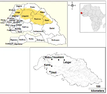
The Ferlo zone is located in the West African Sahel be-tween 15˚ and 16˚30 north and 13˚30 and 16˚ west. It extends from the valley of the Senegal River, in the north, to the limits of edge of the Peanut Basin in the south, covering more than 60,000 km2 [7].
Administratively, the Ferlo covers the entire region of Matam as well as part of the regions of Saint-Louis and Louga (Figure 1). The study was conducted in five par- ticular locations in the Ferlo: Widou, Téssékéré and Labgar in the north and Kamb and Déali in the south. The selection of these particular sites was motivated by two rainfall gradients: one that runs East-West (including Widou, Téssékéré and Labgar) and another that runs North-South (including Widou, Kamb and Déali) (Fig- ure 1).
The climate of the Ferlo region is similar to much of
the Sahel and characterized by two main seasons: a dry season that lasts nine months from October to June, and a rainy season of three months. Total annual rainfall is both low and highly variable, with an average of 422.6 mm per year from 1951-2004, but with a standard de- viation of 126.8 mm per year [8]. Mean annual tempera- ture oscillates around 27.7˚C and fluctuates between a maximum average of 30.2˚C in the month of October and a minimum of 24.5˚C in the month of January [9].
Pedologically, the study zone is part of the sandy Ferlo region characterized by a succession of dunes and hilly low-lying areas that contain a different soil type than found on the tops of the dunes or at the bottom of a hill [10]. The low-lying areas effectively have a ratio of clay that is greater than at the tops of the dunes.
The study site also contains two types of hydrological layers: one which is deep aquifers from the Mastricht and Eocene and another which is less deep and comes from the terminal continental and quartneary aquifers [11].
2.2. Woody and Herbaceous Species Inventory
The sampling strategy consisted of randomly locating 90 experimental plots of an area of 2500 m2. Placement of the plots was done using the 3-4-5 method to find right angles. This surface corresponds to the minimal area needed for study of woody vegetation in the Sahel [12, 13]. In each experimental plot, all individuals were iden- tified that had a basal circumference greater than 10 cm. Dendrometric measurements were also taken, including circumference at the base of the trunk, crown diameter, and total height. The distance between individuals was measured using the nearest-neighbor method [14].
Individuals with a basal circumference less than 10 cm were listed in order to determine the regeneration rate of species populations related to both seed and seeling re- generation. Individuals that were cut or standing dead were also listed in order to evaluate rates of mortality and human impact. Species identification was conducted us- ing previously published guides to the flora of Senegal [15]. Certain species identifications were updated using more recent classification schemes [16].
2.3. Data Analysis
Figure 1. Site locations in the Ferlo zone in central Senegal.
(
)
(
)
210, 000 Theoretical density ind ha
dmoy =
The dominance of a species is given as its ground sur-face area occupied in meters per hectare [18]. The ground surface area of each species (Ste) is found by adding the basal circumference of all of the individuals within that species that are at least 10 cm. Crown cover corresponds to the surface on the ground covered by the crown in meters per hectare. Similarly to ground cover, species crown cover (Sc) is defined as the sum of the crown cover for each individual:
2
π 4
D Sc=
∑
where D represents the average crown diameter for all of the individuals.
Relative densities were also calculated by circumfe- rence and height class to determine the distribution of individuals according to these variables. The distribution of individuals according to circumference allows for evaluation of the horizontal structure of the community and populations; the vertical structure, similarly, can be assessed by the distribution of individuals by height. In- dividuals are classified as trees if their height is greater
than seven meters and are classified as shrubs if less than seven meters [19,20]. To test for significant pairwise differences between sites for the various measures of population structure, Welch’s 2-sample t-tests were com- puted using XLSTAT 6.19. All analyses were conducted using Microsoft Excel 2007.
3. Results
3.1. Population Density
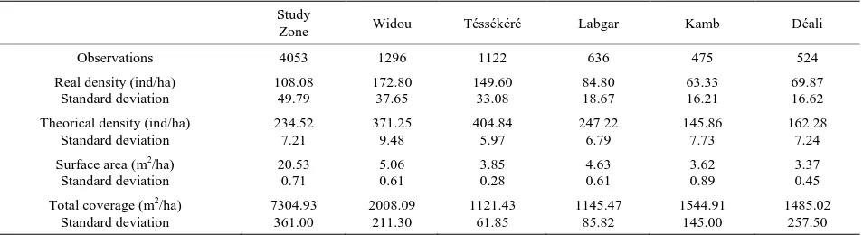
Over the entire study area, 4055 individuals were listed, which corresponds to an overall density of 180.22 in- dividuals per hectare, distributed across all taxonomic groups. Broken down by site, 1296 individuals were identified in Widou, 1122 in Téssékéré, and 636 in Labgar, 475 in Kamb, and 524 in Déali, with densities being 172.8, 149.6, 84.8, 63.3, and 69.9 respectively (Table 1).
The most abundant species were Balanitesaegyptiaca
(L.) Delile (1311 individuals), Calotropisprocera (Aiton) W.T.Aiton (1176 individuals) and Boscia senegalensis
(Pers.) Lam. ex Poir. (720 individuals). These species cumulatively represent 88.3 percent of the individuals found in the study area, with per hectare densities of 35, 31.4, and 19.2 individuals respectively. The mean dis- tance between individuals is 5.2 m in Widou, 5.0 m in
N
E W
Table 1. Structural characteristics of the study sites and the Ferlo zone.
Study
Zone Widou Téssékéré Labgar Kamb Déali
Observations 4053 1296 1122 636 475 524
Real density (ind/ha) Standard deviation 108.08 49.79 172.80 37.65 149.60 33.08 84.80 18.67 63.33 16.21 69.87 16.62 Theorical density (ind/ha)
Standard deviation 234.52 7.21 371.25 9.48 404.84 5.97 247.22 6.79 145.86 7.73 162.28 7.24 Surface area (m2/ha)
Standard deviation 20.53 0.71 5.06 0.61 3.85 0.28 4.63 0.61 3.62 0.89 3.37 0.45 Total coverage (m2/ha)
Standard deviation 7304.93 361.00 2008.09 211.30 1121.43 61.85 1145.47 85.82 1544.91 145.00 1485.02 257.50
Téssékéré, 6.4 m in Labgar, 8.3 m in Kamb, and 7.8 m in Déali, with theoretical densities being 371.25, 404.84, 247.22, 145.86, and 162.28 trees per hectare, respectively. The theoretical densities are largely greater than actual densities, regardless of the site. This tendency has also been noted across the entire study region (Table 1).
3.2. Population Coverage
Basal coverage evaluated by surface area is 20.53 m2·ha−1 for the entire study zone. Coverage area was found to be greater in Widou and Labgar and lower in Téssékéré, Kamb and Déali. However, the values for the surface area between these two stratifications are not signifi- cantly different (Table 1). The species dominating sur- face area are B. aegyptiaca (6.7 m2·ha−1), Adansonia digitata L. (4.3 m2·ha−1), C. procera (1.7 m2·ha−1) and B.
senegalensis (1.5 m2·ha−1). These species make up 69.2% of basal area coverage.
Crown cover is 7305 m2·ha−1 for the entire study re-gion. Divided by sub-sites, this is broken into 2008 m2·ha−1 in Widou, followed by Kamb (1545 m2·ha−1), Déali (1485 m2·ha−1), Labgar (1146 m2·ha−1) and Tés- sékéré (1121 m2·ha−1), which makes up 27.49, 21.15, 20.33, 15.68, and 15.35 percent of total crown cover area.
Balanitesaegyptiaca, C. procera and B. senegalensis co- ver more than half of total surface area in Widou (69.21%), Déali (65.38%) and Labgar (51.05%). These species only cover, however, 39.44 and 38.79 percent respectively of the area in Téssékéré and Kamb.
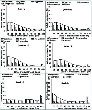
3.3. The Distribution of Individuals by Circumference
The demographic structure of populations, illustrated by the distribution of individuals according to size classes across all species, shows a roughly log-normal distri- bution in Widou, Téssékéré and Labgar (north Ferlo) and a uniform distribution for the other sites (Figure 2).
The overall distribution for the study sites appears log-normal. This pattern holds when considering inde- pendently the most abundant species (Figure 2). In the
Ferlo in general, and especially in the more northern parts, more than 50 percent of the populations of woody taxa are individuals with a circumference greater than 40 cm. In the southern part of the study region, 52 percent of the individuals at Kamb and 35 percent of the individuals at Deali have a circumference greater than 60 cm (Fig- ures 2(e)and(f)).
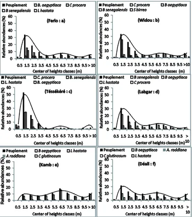
3.4. The Distribution of Individuals According to Height
The distribution of woody taxa by height follows a un-imodal distribution in the northern part of the study re-gion. In these sites, the overall community as well as the dominant species is predominantly (more than 60%) made up of individuals with a height of less than four meters (Figures 3(b), (c) and (d). The same pattern is seen when considering the entire study region (Figure 3(a)). By contrast, in the southern part of the region, the distribution of individuals by height is slightly irregularly distributed, with a majority of individuals of small size (Figures 3(e)and (f)). Nevertheless, individuals with a height greater than seven meters are also well repre- sented in Kamb and Déali, with 36 and 25 percent of the populations, respectively.
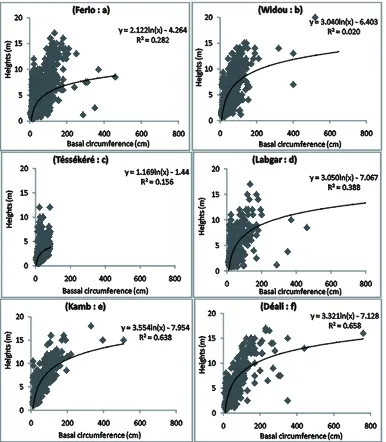
3.5. Growth Relationships between Height and Circumference
Figure 2. Structure of individuals according to circumference, representing the most abundant species in the study sites.
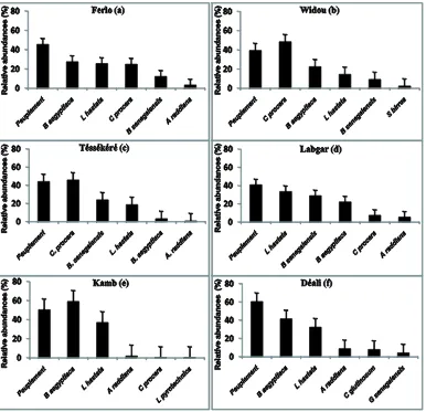
3.6. Regeneration of Populations
The distribution of young plants in the study region (Figure 5(a)) shows that woody species have regenerated at greater than 45 percent. These young plants mainly contain individuals of the species B. aegyptiaca (27.76%),
Leptadenia hastata (Pers.) Decne. (25.86%), C. procera
(25.15%), B. senegalensis (12.43%) and A. raddiana
(3.52%). In Widou, where the woody population regene-rates at 39.47% (Figure 5(b)), the young plants are mainly of the species C. procera (48.63%), B. aegyptiaca
(22.60%), L. hastata (14.67%), B. senegalensis (9.47%) and Sclerocarya birrea (A. Rich.) Hochst (2.48%). The same trend is seen in Téssékéré (Figure 5(c)) where
young plants make up 44.26% of total population and the most abundant are C. procera (46.01%), B. senegalensis
(24.13%), L. hastata (18.97%), B. aegyptiaca (3.59%) and A. raddiana (1.12%). In Labgar (Figure 5(d)), the species that regenerate the most are: L. hastata (33.78%),
B. senegalensis (29.05%), B. aegyptiaca (22.30%), C.
procera (7.66%) and A.raddiana (5.63%). Regeneration
rates are higher in the southern part of the study zone. Young plants represent 50.61% of woody populations in Kamb and 60.68% in Déali. In these locations the species that regenerate best are B.aegyptiaca (59.40% and 41.71%)
and L. hastata (37.24% and 32.60%) respectively in
Figure 3. Structure of individuals according to height, representing the most abundant species in the study sites.
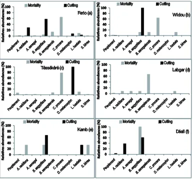
3.7. Degradation of Woody Populations and Human Impacts
The rate of human impacts on the woody populations of the Ferlo study region varies as a function of particular sites (Figure 6). In the entire study region, the rate of mortality is lower than one percent. C. procera has the highest rate of mortaility (60%) with the next highest being B. aegyptiaca (58.33%) and A. raddiana (29.16%), the latter of which is predominantly exploited by cutting (Figure 6(a)). In Widou and Téssékéré, mortality is also dominated by C. procera, making up 64% and 78.48% respectively. In these sites, exploitation by cutting only applies to B.aegyptiaca (in Widou) and D. melanoxylon
(in Téssékéré) (Figures 6(b) and (c)). In Labgar, there were no noted events of mortality, but exploitation by pruning was common for B. senegalensis (66.67%). In
the southern section of the study zone, cutting is more clearly on B. aegyptiaca with 66.67% of individuals af-fected in Kamb and 61.11% of individuals afaf-fected in Déali. The second-most impacted species is L. hastate
(33.33%) in Kamb and A. raddiana (38.89%) in Déali (Figures 6(e)and(f)). Mortality in Déali was exclusively noted for B. aegyptiaca, but was noted in Kamb for A. raddiana, B. aegyptiaca and S. birrea with a similar rate of around 30% (Figure 6(e)).
4. Discussion
Figure 4. Regression lines describing the relationship between height and circumference for individuals surveyed.
extinction in the medium or long-term species threat ex- acerbated by an operation that fails to implement inter- vention measures to reverse this process [22,23].
Regarding the structural composition of populations and communities, the density of woody taxa is generally low in the study zone. There is also much inter-site va- riability, with higher densities in Widou and lower densi- ties in Kamb. We find, however, that observed densities are higher in our particular study zones than in previous- ly published work [14]. Between 1989 and 1998, density was found to range between 124 and 129 individuals per hectare, which is slightly lower than the density observed in this study of 180.22 individuals per hectare. However, densities observed in our analyses are lower than even older studies [3,5,24]. The abundance of certain species,
like C. procera and B. senegalensis, agrees with data from [25]. According to [25], the progression of species that are supposedly resistant to drought does not seem to be inhibited by elevated rains.
Figure 5. The distribution of young plants in the study sites.
the sites, with high coefficients of variation stipulating an aggregate distribution of individuals. Such an aggregate distribution has been shown in several studies conducted in the Ferlo zone [4,13,14,31].
The surface area is relatively low and varies between sites and species. It is highest in Widou and Labgar and lowest and statistically similar in Téssékéré, Kamb and Déali. Basal coverage is higher in Labgar than in Tés- sékéré despite the higher density found in Téssékéré.
This pattern could possibly be explained by the abun- dance of individuals with large trunks in Labgar. The woody populations in the study area are largely domi- nated by B. aegyptiaca whose rooting zone area is nearly double that of A. digitata, despite the size of the latter’s trunk. In these areas, it seems that the high density of B. aegyptiaca compensates for the large trunk size of A. digitata, allowing for co-existence [32].
Crown cover is low in the study reason because of grazing activity that tends to depress the development of woody taxa [33,34]. It varies according to sites, with higher crown cover in Widou, Kamb and Déali and lower
cover in Téssékéré and Labgar. Effectively B. aegyptiaca
alone represents more than half of woody cover in Widou and Déali. In Kamb, B. aegyptiaca associates with A.
raddiana in forming semi-joined crowns that cover ap-
proximately the same area despite lower densities. The woody population is mainly constituted of indi- viduals with a small size as seen in our results for the structure of the populations broken down by circum- ference class. The low representation of individuals with a circumference greater than 100 cm can be explained by charcoal production, wood for construction, and fire- wood in the region that favors high-circumference spe- cies, as well as using the foliar resources for livestock during the dry season including C. procera and B. sene-
galensis in the northern part of the zone, whereas the
southern part of the region is dominated by B. aegyptia- ca.
Figure 6. Mortality and human impact on woody populations of the study area.
Considering the entire study region, the young plants of
B. aegyptiaca are the most abundant, followed by C. pro- cera and B. senegalensis.
The considerable ability to regenerate found among B. aegyptiaca can be explained by their ability to maintain photosynthetic activity through the year [14]. Site-spe- cific analyses reveal that regeneration rates are higher in the southern part of the Ferlo, where there are more adult individuals than in the north. This higher rate of regen- eration is correlated with higher woody cover in the southern part of the region. This pattern is likely ex- plained by patterns of higher precipitation in the southern part of the study zone. Woody cover offers favorable conditions for seeds to germinate and saplings to grow [4]. Species which generate better in the southern region are more dominant, except for in Labgar, which is domi- nated by young plants of L. hastata. In the north part of the zone, B. aegyptiaca is better at regenerating. In the southern part, the species with higher ability to regene- rate also happen to be less palatable to livestock and have fewer ethnobotanical uses [9]. The regeneration of spe- cies in the Ferlo zone shows a gradual evolution accord-
ing to these patterns.
The rate of human exploitation is relatively low for these populations in the Ferlo zone. In this area, human impacts are most often due to selective pruning for fire- wood and other cutting of useful species. Many of the species undergoing impacts from humans have important ethnobotanical uses [9].
5. Conclusion
The present study evaluated the structural diversity of woody taxa in the Ferlo region of the Sahel, in Senegal. This structural diversity is relatively low compared to other agroecological zones of Senegal. The dominance of woody species, such as B. aegyptiaca, B. senegalensis
and C. procera shows that these taxa have developed
of central Senegal. This southern zone is much impacted by human activity, especially agricultural activity.
REFERENCES
[1] L. E. Akpo, A. Gaston and M. Grouzis, “Specific Struc- ture of a Sahelian Vegetation: Case of Wiidu Thiengoli (Ferlo, Senegal),” Bull. Mus. Natl., Paris, 1995, pp. 39- 52.
[2] A. Ba, “Evaluation des Revenus des Agropasteurs, leurs Demandes de Formation et d’Education, et Leurs Capa- cités Contributives: cas de l’Unité Pastorale de Bélèl Bogal dans le déPartement de Podor au Sénégal,” Ph.D. Dissertation, ENEA, Dakar, 2007.
[3] A. T. Diop, “Les ressources ligneuses de la zone sylvo- pastorale du senegal: Evolution, gestion et perspectives de developpement,” Communication Présentée à l’Atelier Tenu à l’Université Cheikh Anta Diop de Dakar sur Forêt, Environnement et Développement du 22 au 26 mai 1989.
[4] L. E. Akpo and M. Grouzis, “Influence du couvert sur la regeneration de quelques especes ligneuses saheliennes (Nord Sénégal, Afrique Occidentale),” Webbia: Journal of Plant Taxonomy and Geography, Vol. 50, No. 2,pp. 247-263.
http://dx.doi.org/10.1080/00837792.1996.10670605
[5] J. Piot and A. Diakite, “Système de production d’elevage au senegal. Etude du couvert ligneux,” Compte rendu de fin d’etude. C.I.T.: Nogent sur Marne, ISRA: Dakar- Hann, 1983, p. 30.
[6] M. Miehe and Marburg, “Surveillance Continue de la Végétation dans le Périmètre Expérimental à Widou Thien- goly dans le cadre des projets sénégalo-allemands, 1981- 2007. Dispositif expérimental, méthodes de suivi et pers- pectives d’évaluation,” Atelier sur le transfert du patri- moine scientifique du PAPF, Dakar, Senegal, 6 June 2007, p. 26.
[7] A. Wane, V. Ancey and B. Grosdidier, “Les unités past- orales du Sahel sénégalais, outils de gestion de l’élevage et des espaces pastoraux. Projet durable ou projet de dé- veloppement durable?” Développement durable et ter- ritoires [En ligne], Dossier 8: Méthodologies et pratiques territoriales de l’évaluation en matière de développement durable, 2006.
http://developpementdurable.revues.org/3292
[8] G. Faye, P. L. Frison, S. Wade, J. A. Ndione, A. C. Beye and J. P. Rudant, “Etude de la saisonnalité des mesures des diffusiomètres scat: Apport au suivi de la végétation au sahel, cas du Ferlo au Sénégal,” Rev Télédétection No 10, 2011, pp. 23-31.
[9] K. Niang, “L’arbre Dans les Parcours communautaires du Ferlo-Nord (Sénégal),” Ph.D. Dissertation, FST/UCAD, 2009, p. 67.
[10] M. Diouf, “Caractéristiques fondamentales de la feuil- laison d’une espèce ligneuse sahélienne: Acacia tortilis (forsk) hyane, variation selon les microsites topogra- phiques du Ferlo (nord-Sénégal),” Ph.D. Dissertation, FST-UCAD, 2003, p. 103.
[11] P. Michel, “Les bassins des fleuves Sénégal et Gambie: étude géomorphologique,” Ph.D. Dissertation, Orstom, 3
tomes, 1973, p. 753.
[12] G. Boudet, “Manuel sur les pâturages tropicaux et les cultures fourragères,” 4e éd, Paris, Ministère de la coopération, Manuels et Précis d’Elevage No 4, 1984, pp. 1-254.
[13] L. E. Akpo, F. Bada and M. Grouzis, “Diversité de la végé- tation herbacée sous arbre: Variation selon l’espèce lig- neuse en milieu sahélien,” Candollea No 58, 2003, pp. 515-530.
[14] M. Diouf, L. E. Akpo, A. Rocheteau, F. Do, V. Goudiaby and A. L. Diagne, “Dynamique du peuplement ligneux d’une végétation sahélienne au Nord-Sénégal (Afrique de l’ouest),” J. Sci., Vol. 2, No. 1, 2002, pp. 1-9.
[15] J. Berhaut, “Flore du Sénégal, deuxième édition plus com- plète avec les forêts humides de Casamance,” 1967, p. 485.
[16] J. P. Lebrun and A. L. Stork, “Enumération des plantes à fleurs d’Afrique tropicale. Conservatoire et Jardin bota- niques de Genève,” Vol. I, II, III, IV, 1991, 1992, 1995, 1997, pp. 249, 257, 341, 712.
[17] P. Wouters and V. Notelaers, “L’espace entre les arbres et la densité des peuplements,” Sylva Belgica No 106, p. 4. [18] J. Rondeux, “La mesure des arbres et des peuplements
forestiers,” Les presses agronomiques de Gembloux, 1993, pp. 16-59.
[19] A. Aubreville, “Accord à Yangambi sur la nomenclature des types africaine de végétation,” Bois et Forêts des Tropiques No 51, 1957, pp. 23-27.
[20] J. Touffet, “Dictionnaire essentielle d’écologie,” Ouest France, 1982, p. 108.
[21] H. N. Fonton and P. Sagbo, “Modélisation des Distri- butions des Paramètres Dendrométriques d’une Espèce Ligneuse Dominante en Peuplement Naturel,” Annals of Forest Science, Vol. 61, No. 6, 2004, pp. 545-549. http://dx.doi.org/10.1051/forest:2004049
[22] E. Semereab, J. Philippart and J. L. Doucet, “Evaluation de la Présence de Forêts a Haute Valeur Pour la Con- servation Dans la Concession Forestière Attribuée à Gau Services (Cameroun) Selon le Concept Défini par le Principe du Forest Stewardship Council,” Nature + asbl, Gembloux, 2010, p. 57.
[23] A. Diallo, E. C. Agbangba, O. Ndiaye and A. Guisse, “Eco- logical Structure and Prediction Equations for Estimating Tree Age, and Dendometric Parameters of Acacia Se- negal in the Senegalese Semi-Arid Zone-Ferlo,” Ameri- can Journal of Plant Sciences, No 4, 2013, pp. 1046-1053. http://dx.doi.org/10.4236/ajps.2013.45129
[24] H. Poupon, “Structure et dynamique de la strate ligneuse d’une steppe sahélienne au nord du Sénégal,” Orstom ed. (Etudes & Thèses), Paris, 1980, p. 307.
[25] A. T. Diop, “Les ressources de l’aire pastorale de Tatki: Inventaire et étude du mode d’exploitation, propositions de plan d’aménagement et de gestion rationnelle,” LNERV, Dakar, 1987, p. 190.
and J. Piot, “Espèces ligneuses et herbacées dans les éco- systèmes sahéliens paturés de Haute-Volta,” ACC GRI- ZA (LAT), GERDAT, 1983, p. 124.
[28] M. Benoit, “La dune de Gondol. Dégradation d’un bio- tope ou histoire d’un paysage?” ORSTOM, Paris, Cah. Sci. Hum No 24, 1988, pp. 487-501.
[29] B. Sambou, A. Goudiaby, J. E. Madsen and A. T. Ba, “Etude comparative des modifications de la flore et végétation dans les forêts classées de Koutal et de l’Ile Kouyong (Centre-Ouest du Sénégal),” Journ. D’Agric. Trad. Et de Bota. Appl., nouvelle série, XXXVI No 1, 1994, pp. 87- 100.
[30] C. Vincke, “La dégradation des systèmes écologiques sa- héliens. Effets de la sécheresse et des facteurs anthro- piques sur l’évolution de la végétation ligneuse du Ferlo (Sénégal),” MFE, UCL-FSA/UEF, 1995, p. 82.
[31] A. Diallo, M. N. Faye and A. Guissé, “Structure des peu-
plements ligneux dans les plantations d’Acacia senegal (L.) Wild dans la zone de Dahra (Ferlo, Sénégal),” Rev. Ecol., Terre et Vie No 66, 2011, pp. 415-427.
[32] I. Coly, L. E. Akpo, H. Dacosta, F. Diome and R. Malou, “Caractérisation agro-écologique du terroir de la Nema au Saloum (Sénégal): Les systèmes d’utilisation des terres et diversité du peuplement ligneux,” Journal des Sciences, No. 1, 2001, pp. 9-18.
[33] F. Chambris, “Dynamique des pâturages sahéliens: Influ- ence des pluies du substrat et de l’exploitation animale. Exemple du Ferlo septentrionale, Sénégal, 6 années d’obser- vation à Labgar,” Daa, Ensa, Montpellier, 1988, p. 68.