http://dx.doi.org/10.4236/wsn.2014.69018
Cars as a Diffuse Network of
Road-Environment Monitoring Nodes
Marco Allegretti
1, Silvano Bertoldo
21Envisens Technologies s.r.l., Torino, Italy
2CINFAI (Consorzio Interuniversitario Nazionale per la Fisica delle Atmosfere e delle Idrosfere), c/o Dipartimento di Elettronica e Telecomunicazioni, Politecnico di Torino, Torino, Italy
Email: marco.allegretti@polito.it, silvano.bertoldo@polito.it
Received 18 July 2014; revised 18 August 2014; accepted 17 September 2014
Copyright © 2014 by authors and Scientific Research Publishing Inc.
This work is licensed under the Creative Commons Attribution International License (CC BY). http://creativecommons.org/licenses/by/4.0/
Abstract
The present paper aims to describe the conceptual idea to use cars as sensors to measure and ac-quire data related road environment. The parameters are collected using only standard equip-ment commonly installed and operative on commercial cars. Real sensors and car sub-systems (e.g. thermometers, accelerometers, ABS, ESP, and GPS) together with other “implicit” sensors (e.g. fog lights, windscreen wipers) acquire and contain information. They are shared inside an in-vehicle communication network using mainly the standard CAN bus and can be collected by a simple cen-tral node. This node can also be available on the market without too expensive costs thanks to some companies which business is devoted to car fleet monitoring. All the collected data are then geolocalized using a standard GPS receiver and sent to a remote elaboration unit, exploiting mo-bile network technologies such as GPRS or UMTS. A large number of cars, connected together in a diffuse Wireless Sensor Network, allow the elaboration unit to realize some info-layers put at the disposal of a car driver. Traffic, state of the road and other information about the weather can be received by car drivers using an ad hoc developed mobile application for smartphone which can give punctual information related to a specific route, previously set on the mobile phone navigator. The description of some experimental activities is presented, some technical points will be ad-dressed and some examples of applications of the network of cars “as sensors” will be given.
Keywords
Cars, Meteorological Sensor, Traffic Sensor, Weather, Wireless Sensor Network, WSN, Cars as a Sensor, Commercial Sensors, Car Sensors, Road Environment Sensors, Environment Monitoring
1. Introduction
essential to avoid dangerous situation and improve safety.
Following a scheme we have already implemented for specific information concerning rain distribution (de-scribed below), we are developing a more general approach using only standard equipment commonly installed and operative in commercial cars.
Let us assume that a driver is choosing on the navigator of his smartphone the route he intends to follow. A specific app installed on his own smartphone is checking its position and, at the same time, is consulting a data-base containing a set of specific georeferenced information about the surrounding area and, in particular, along the road indicated by the navigator: the app gets the data from the database and reports them on the map which is presented to the driver.
A similar experimental system has been already realized although limited to rain data. Since 2004 the Remote Sensing Group (RSG), the local unit of Consorzio Interuniversitario per la Fisicadelle Atmosfere e delle Idros-fere (CINFAI) at Politecnico di Torino, started to develop a first fully operational (although experimental) net-work of short range X-band mini weather radars. Their low cost, the lack of any special requirements for instal-lation, practically maintenance-free and the possibility to be remotely controlled with software adjournments, allow their installations almost everywhere. Arain image map, adjourned each minute with a high resolution within a range of 30 km, is produced for real time monitoring of weather [1].
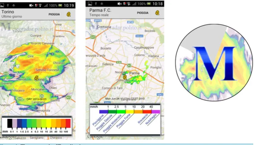
Two mobile applications for Android© systems have been already developed by Envisens Technologies s.r.l.
(EST). The first, already available for free on Google store©, is called Meteoradar-IT and allow users to have a look at the precipitation in real time over the areas monitored by the different radars already installed (Figure 1). The second is Meteoradar-IT-OnRoute, it is experimental only, and it checks on real time for the presence of rain over the route set on the navigator. It is an example of car driver service to communicate a possible alarm if a severe rainfall event occurs on a predefined route. Because the system is also able to provide projection son the movement of the rain fields in the next 30 minutes, the car driver can be also informed in advance of the rain situation along his chosen route for the next 30 minutes.
[image:2.595.102.531.470.714.2]The idea to use the moving cars to acquire meteorological and traffic data is not presented here for the first time. Especially in the USA, some experiments and discussions were already addressed since 2006 [2]. They are based on dedicated meteorological sensors installed onboard to the car [3], on the interconnection between the car and other infrastructure to improve the safety, and on the acquisition of cars parameters to improve drivers’ safety [4]. The innovation presented here is that data and information are acquired using the “car as a sensor” as it is and, at least to start, using only commercial fleet of cars already connected in a network for commercial and insurance purposes.
The new conceptual idea of a Wireless Sensor Network (WSN) for meteorological purposes, traffic and roads monitoring can be technically feasible because, presently, cars are already provided with a set of sensors, sys-tems, and technologies which are commonly used to improve car and passengers’ safety and comfort: ABS (An-tilock Breaking System), ESP (Electronic Stability Comfort), tire pressure control and accelerometers, thermo-meters to give the passengers the indication of the temperature outside the vehicle and possibly turn on or off the automatic air-conditioner and rain sensors, on newer cars, to automatically turn on the windscreen wipers.
The set of information from the sensor are collected inside an in-vehicle car network. Furthermore more re-cent cars are already equipped with an integrated GPS navigator, thus knowing the position of the car itself.
Of course, all these data need to be centralized in order to enter in the construction of the database, accessed by any user. However in most European countries numerous fleets of cars already presents devices for transmit-ting data for fleet management purposes, namely car position plus parameters like sudden strong deceleration, to a central node.
In other words, while in the future most cars may transmit their on-board information to some centralized collector, for the time being, it is possible to take advantage of the telecommunication structures already opera-tive for many cars fleet (Figure 2).
It is to note that the central collector on the WSN car can be also already installed in common commercial cars.
2. Cars as a Sensor Node
As reported in a paper of 2008 [5], a modern car can be equipped with more than 100 different sensors and the entire automotive systems application for sensors can be divided in three main areas: power train, chassis, and body.
Most of the sensors of the three areas are not useful, directly or not directly, for road environment monitoring. However:
• Accelerometers (mainly used for motion detection and impact measurements) can be used to monitor the
[image:3.595.109.513.411.682.2]state of the streets.
Figure 2.Operational scheme of the proposed diffused Wireless Sensor Network, from the sensors (i.e. the
• Speed monitor can be used, after re-analysis, for traffic estimate.
• Angular and linear position sensors or gyroscope (to measure, for instance, steering angle, mirror adjustment, seat position and light adjustment) can be used together with the accelerometers to evaluate the state of the roads.
• Sensors restricted to the luxury cars, such as radar and video sensors to assist the driver during the journey and during parking operations, can give additional information.
• External temperature sensors are especially important when near zero degree Celsius are measured.
• Pressure sensors are essential to characterize the atmosphere.
• Rain sensors, present on some modern vehicles, are capable to detect when it is raining and automatically
activate the windscreen wipers
Other potentially useful complex systems, made by a set of sensors, are ABS and ESP. They work when some criticality is detected on the road in order to improve the safety of the car, at first glance. Their information seems useless because criticalities on the road may be due not only to ice, water and other meteorological events but also to the way the car is used and its stability problems. However, the occurrence of the same output from different cars, in the same road section, at the same time, is certainly signaling specific road problems.
It is to be underlined that data acquired and measured by the sensor and the systems above are available on the CAN (Controlled Area Network) bus (see paragraph 2.3) of the car: it is consequently technically simple to collect them for future use.
2.1. “Implicit” Sensors and Systems
Together with the specific sensors and subsystems of immediate use for road environment monitoring, other de-vices and car apparatus can be used as “implicit” sensors.
The fog lights are the first example of this kind of “implicit” sensors: if a set of cars has the fog lights on in a road section, it gives evidence of fog presence in that specific road section.
The windscreen wipers are another example: if they are turned on for a certain interval of time and on a cer-tain number of cars, they indicate that it is raining; their speed gives also an indication of the intensity of the rain (see Section 5).
In order to have reliable information coming from this kind of sensors, it is of course necessary to consider a set of car and not a single one. Indeed the fog lights or windscreen wipers may have been turned on for different reasons by a single driver. Therefore considering the information coming from a single car may lead to a mi-sunderstanding of the meteorological situation of a specific area.
The tire pressure sensors are the last example of “implicit” sensor. You can note that the pressure is measured with a real pressure sensor. But the measured pressure can be put in relation with the temperature of the air and the temperature of the road. The tire pressure sensors implicitly can act as road temperature sensors giving in-formation related to the state of the road and the surrounding environment.
2.2. Communication on the In-Vehicle Network
The most recent research trend concerning the communications on the in-vehicle network, also called Smart Car Sensor Network (SCSN), is mainly twofold: to improve the performance of the communication with new stan-dards and protocols and to implement innovative applications devoted to improve safety and reliability of the current ones [6].
In 1994 the Society for Automotive Engineers (SAE) classified the communication protocols into three cate-gories (A, B, C) on the basis of the data transmission speed and their capabilities to manage different functions. A fourth category (D) was added later [7] [8]. Class A networks are characterized by a data rate lower than 10 kb/s, class B network between 10 and 125 kb/s, class C up to 1 Mb/s and class D includes all the networks re-quiring more than 1 Mb/s.
Readers can refer to [6] for a complete list and a detailed analysis of the traditional protocol for the SCSN communication.
For what concern the usage of a car as a road environment sensor the CAN bus is very suitable. In fact all the car sensors are organized in a SCSN able to collect the acquired measurements and making them available on the traditional CAN bus, which allows also a sufficient data rate. It is simply necessary to connect to the CAN bus also the access point capable to acquire all the information of interest.
3. A WSN of “Cars as Sensor”
3.1. The Cars: The Network Nodes
According to what we have been seeing above, the car may be considered as a sensor itself.
The data can be acquired by a central node, called Access Point (AP), already existing in the cars fleet, send-ing, for the time besend-ing, position and, in many cases, excess deceleration to some centralized unit via UMTS or GPRS. Such existing APs are already connected to the CAN bus and need to be reprogrammed (in some cases the reprogramming operations may be performed remotely).
Of course, in developing the acquisition program, one has to carefully analyze the raw data, programming al-so the final amount of data to be transmitted as a function of car speed and data nature. If, for instance, a car is running at 100 km/h, transmitting, let us say, 10 data each 30 seconds, it implies giving road environment in-formation along and approximately 1000 m track. Another example is related to when the on-board system rea-lizes the car is entering in a fog bank: the corresponding information has to be transmitted immediately.
A structure of the message sent by the car to the central unit can be very simple. It must contain sensor infor-mation (temperature, accelerometers data, indication of speed of windscreen wipers…) together with coordi-nates and, possibly speed, of the car.
3.2. The Central Elaboration Unit
The central elaboration unit is devoted to the storage of the data and their elaboration. It should be connected to internet (and possibly to the mobile phone network) in order to receive all the data coming from the cars. The central unit is the central node of the network. It can be made by different hardware units, PCs and servers and it should be located in a safe place. It should perform different tasks:
• It acts as database server, because a well-designed database can be implemented to collect all the data com-ing from a huge set of cars in the referrcom-ing area.
• It acts as a web server, in order to provide web services that can be browsed by citizens and drivers.
• It acts as an application server to deploy data to mobile apps developed for Android© and Mac IOS© opera-tive systems (e.g. for indication of serious meteorological events on a predefined route, for traffic jam…).
• It allows specific and ad-hoc developed services to run (e.g. forecast services).
• It executes specific ad-hoc routine developed to signal a possible warning due to severe meteorological situ-ation over a segment of a specific area (e.g. fog alert, rainfall alert, traffic jam alert…).
• It gives authorized users the possibility to access to the database and download data.
• In case of meteorological usage of the cars as sensors, it integrates data coming not only from cars, but also from other weather monitoring tools (weather radars, rain gauges, weather stations…) in order to run im-proved forecast algorithm working on different types of data.
All the parameters measured by the cars and made available on internet are part of the so called “Internet of Things” world. The cars become intelligent embedded systems capable to share some of their characteristics and parameters and communicate the information to other car drivers who have the mobile applications, in order to improve their safety.
4. Examples of Application
4.1. Rain Monitoring
Accurate observation of precipitations in terms of intensity and location is important for many applications: hydro-geological risk management, hydroelectric power, road maintenance, emergency planning, and tourism
are only some examples of a wider number of fields. For example in [10] it is shown the importance of
high-resolution rainfall data using X-band radar network for what concern monitoring operation of extreme in-tense events and in complex orography environment.
There are severaloperative techniques for rainfall intensity measurements such standard C-band or S-band weather radar, satellites, microwave links [11], acoustic rain gauges [12] and even radio links from cellular communication [13].
The usage of rain sensor installed on the car and the indication of the functioning and speed of the windscreen wipers may be another innovative method to monitor rain fields. The cars are then used as a huge number of rain gauges.
Some models and experiments about using the moving cars as rain gauges are presented in [14] [15] with very good results. They showed also that is possible to extrapolate a W-R (windscreen wipers speed-rain) relationship which gives an indication of the amount of rain over a specific area.
Radars suffer time variable bias in rainfall estimation [16] and should be calibrated often in order to have a better rain estimation with a point precipitation network. Results in [17] have shown that a high number of pos-sibly inaccurate measurement devices (moving cars used as rain gauges) provide more reliable areal rainfall es-timations than a lower number of precise measurement devices (stationary gauges). Therefore the cars may also be used to improve standard radar estimation and to calibrate X-band weather radars.
4.2. Fog Alert
The presence of fog along a road is often a cause of car accidents. The fog lights of the cars, as previously said, can be used as implicit sensors. Let us consider a set of cars where the information related to the fog lights on or off is acquired by the central node of the in-vehicle WSN and sent to the central elaboration unit. Let us consider also that two cars are moving in the same direction and the driver of the second car is equipped also with a smartphone with the application capable to signal the presence of fog (similar to the one described in Section 2). The first car turn on the fog lights, the information is sent to the central elaboration unit and the driver of the second car, who has previously set his route on the application, receive the alert for the fog in the next 10 kilo-meters on his smartphone, so he can reduce its speed and turn on the fog lights on his car.
4.3. Traffic Jam Alert
The communication of a traffic jam or a car queue on a highway can be very useful for drivers. Let us consider to have a set of car connected together in a WSN as previously described. All the cars are equipped with a GPS and some accelerometers capable to detect position, speed and accelerations. Combining such data it is possible to detect the traffic on a specific segment of road. If a car driver has previously installed on his smartphone the ad-hoc developed applications can have the indication of the traffic considering information coming from a huge set of vehicle moving in the same direction.
The following Figure 3 shows an example of indication of heavy traffic considering GPS information. It is the results of an experimental project between EST, CINFAI and another company devoted to the production of car equipment for car fleet control for assurance purposes in 2013. The same technology can be adopted in the proposed WSN.
4.4. Data Input to Meteorological Models
Detailed data are the most important input information to improve the local meteorological forecast and the need of large amount of meteorological and climatological information is always growing due to the increasing com-plexity of the numerical model. Real time forecasting over local areas, potentially provides continuous, high- resolution and large-coverage information, are of high practical use: think of hydrogeological risk management, civil protection activities, road maintenance and safety.
Figure 3. App with real time traffic indication along a user predefined route with data coming from a fleet of cars. Purple color indicates heavy traffic. Icon below refer to other information related to the user defined route (e.g. weather alert, fog alert).
Moreover transfer schemes commonly used in meteorological models, often do not account for small scale variability of the earth surface, because measurements of the atmospheric conditions do not exist in such a high spatial resolution to force the models. A high resolution grid of data coming from the ground improve a lot the performances of the models or validate the models themselves, and ad hoc WSNs can be used for these purposes [17].
The cars, used as road environment sensors are capable to acquire meteorological parameters (rain intensity, temperature, humidity…). The acquired information can be used as further input data for meteorological models.
5. Conclusions and Outlooks
The feasibility of WSN made by cars was described. Each car is a sensor node of the WSN and exploits only the sensors and the sub-systems commonly carried on board without adding any other component, possibly except from a simple access point capable to acquire the desired information already available the car internal CAN buses. All the information is sent to a central elaboration unit which made them available to car drivers with some mobile applications.
Future projects and researches should be focused on the hardware realization of an ad hoc access point to be installed on the car to acquire and integrate data measured by different sensors. Moreover, the central elabora-tion unit of the WSN will be designed and some specific services will be implemented. The WSN should be rea-lized, put in test and eventually should be made fully operational.
Acknowledgements
Elettronica e Telecomunicazioni, www.det.polito.it) of Politecnico di Torino.
References
[1] Gabella, M., Notarpietro, R., Bertoldo, S., Prato, A., Lucianaz, C., Rorato, O., Allegretti, M. and Perona, G. (2012) A Network of Portable, Low-Cost, X-Band Radars. In: Bech, J., Ed., Doppler Radar Observations—Weather Radar, Wind Profiler, Ionospheric Radar, and Other Advanced Applications, InTech, 175-202.
[2] Stern, A.D., Shah, V.P., Biesecker, K.J. and Yeung, C. (2007) Vehicle as Mobile Sensing Platforms for Meteorological Observations: A First Look. Proceedings of the 87th AMS Annual Meeting, 23rd Conference on IIPS, San Antonio,
15-18 January 2007. https://ams.confex.com/ams/87ANNUAL/techprogram/paper_118986.htm
[3] Crawford, D. (2012) Pioneering Sensors Collect Weather Data from Moving Vehicles. ITS International, Swanley.
http://www.itsinternational.com/sections/nafta/features/pioneering-sensors-collect-weather-data-from-moving-vehicles
[4] Drobot, S., Chapman, M., Shuler, E., Wiener, G., Mahoney, W., Pisano, P. and McKeever B. (2009) Improving Road
Weather Hazard Products with Vehicle Probe—The Vehicle Probe Data Translator Quality Check Procedures. Trans-portation Research Record—Journal of TransTrans-portation Research Board, 2169/2010, 128-140.
[5] Fleming, W.J. (2008) New Automotive Sensors—A Review. IEEE Sensors Journal, 8, 1900-1921.
http://dx.doi.org/10.1109/JSEN.2008.2006452
[6] D’Orazio, L., Visintainer, F. and Darin, M. (2011) Sensor Networks on the Car: State of the Art and Future Challenges.
Proceedings of Design, Automation & Test in Europe Conference & Exhibition (DATE), Grenoble, 14-18 March 2011, 1-6.
[7] (1994) J2056/1 Class C Application Requirements Classifications. SAE Handbook. Soc. Automotive Eng. (SAE),
Warrendale.
[8] (1994) J2056/2 Survey of Known Protocols. SAE Handbook, Vol. 2, Soc. Automotive Eng. (SAE), Warrendale.
[9] (1994) Road Vehicle, Low Speed Serial Data Communication—Part 2: Low Speed Controller Area Network.
Interna-tional Standard ISO 11519-2:1994.
[10] Allegretti, M., Bertoldo, S., Prato, A., Lucianaz, C., Rorato, O., Notarpietro, R. and Gabella, M. (2012) X-Band Mini Radar for Observing and Monitoring Rainfall Events. Atmospheric and Climate Sciences, 2, 290-297.
http://dx.doi.org/10.4236/acs.2012.23026
[11] Upton, G.J.G., Holt, A.R., Cummings, R.J., Rahimi, A.R. and Goddard, J.W.F. (2005) Microwave Links: The Future
for Urban Rainfall Measurement? Atmospheric Research, 77, 300-312.
http://dx.doi.org/10.1016/j.atmosres.2004.10.009
[12] De Jong, S. (2010) Low Cost Disdrometer. Master Thesis Report, TU Delft, Delft.
[13] Leijnse, H., Uijlenhoet, R. and Stricker, J.N.M. (2007) Rainfall Measurement Using Radio Links from Cellular Com-munication Networks, Water Resources Research, 43, Article ID: W03201. http://dx.doi.org/10.1029/2006WR005631
[14] Haberland, U. and Sester, M. (2010) Areal Rainfall Estimation Using Moving Cars as Rain Gauges—A Modelling Study. Hydrology and Earth System Sciences, 14, 1139-1151. http://dx.doi.org/10.5194/hess-14-1139-2010
[15] Rabie, E., Haberland, U., Sester, M. and Fitzner, D. (2013) Rainfall Estimation Using Moving Cars as Rain Gauges—
Laboratory Experiments. Hydrology and Earth System Sciences, 17, 4701-4712.
http://dx.doi.org/10.5194/hess-17-4701-2013
[16] Krajewski, W.F. and Smith, J.A. (2002) Radar Hydrology: Rainfall Estimation. Advances in Water Resources, 25, 1387-1394. http://dx.doi.org/10.1016/S0309-1708(02)00062-3