Hydrol. Earth Syst. Sci., 16, 4265–4277, 2012 www.hydrol-earth-syst-sci.net/16/4265/2012/ doi:10.5194/hess-16-4265-2012
© Author(s) 2012. CC Attribution 3.0 License.
Hydrology and
Earth System
Sciences
Characterizing interactions between surface water and groundwater
in the Jialu River basin using major ion chemistry and stable
isotopes
L. Yang1,2, X. Song1, Y. Zhang1, D. Han1, B. Zhang1,2, and D. Long3
1Key Laboratory of Water Cycle and Related Land Surface Processes, Institute of Geographic Sciences and Natural
Resources Research, Chinese Academy of Sciences, 11A, Datun Road, Chaoyang District, Beijing, 100101, China
2University of Chinese Academy of Sciences, Beijing, 100049, China
3Bureau of Economic Geology, Jackson School of Geosciences, The University of Texas at Austin, Austin, TX 78758, USA
Correspondence to: L. Yang (yanglihu@igsnrr.ac.cn), X. Song (songxf@igsnrr.ac.cn)
Received: 31 March 2012 – Published in Hydrol. Earth Syst. Sci. Discuss.: 9 May 2012 Revised: 25 October 2012 – Accepted: 25 October 2012 – Published: 20 November 2012
Abstract. The Jialu River, a secondary tributary of the Huaihe River, has been severely contaminated from major contaminant sources, such as a number of untreated or lightly treated sewage waste in some cities. Groundwater along the river is not an isolated component of the hydrologic system, but is instead connected with the surface water. This study aims to investigate temporal and spatial variations in water chemistry affected by humans and to characterize the rela-tionships between surface water (e.g. reservoirs, lakes and rivers) and groundwater near the river in the shallow Qua-ternary aquifer. Concentration of Cl− in north Zhengzhou City increased prominently due to the discharge of a large amount of domestic water. Nitrate and potassium show maxi-mum concentrations in groundwater in Fugou County. These high levels can be attributed to the use of a large quantity of fertilizer over this region. Most surface water appeared to be continuously recharged from the surrounding groundwa-ter (regional wells) based on comparison surface wagroundwa-ter with groundwater levels, stable-isotopes and major ion signatures. However, the groundwater of a transitional well (location SY3) seemed to be recharged by river water via bank infiltra-tion in September 2010. Fracinfiltra-tional contribuinfiltra-tions of river wa-ter to the groundwawa-ter were calculated based on isotopic and chemical data using a mass-balance approach. Results show that the groundwater was approximately composed of 60– 70 % river water. These findings should be useful for a bet-ter understanding of hydrogeological processes at the river-aquifer interface and ultimately benefit water management in the future.
1 Introduction
The Jialu River (JR), the secondary tributary of the Huaihe River, is severely contaminated by a variety of contaminant sources such as a large number of trade waste and the un-treated or lightly un-treated sewage waste in some cities (Zhang et al., 2009). These wastes have resulted in elevated concen-trations of chemical oxygen demand (COD) and ammonia nitrogen (NH3-N) in water within the Zhengzhou region (Lu
et al., 2008) and the lower reaches in the Zhoukou region (Zhao et al., 2005; Xie et al., 2008). Zhang et al. (2009) re-ported that concentrations of alkylphenols in surface water were more enriched in the lower reaches compared with the upper stream, with the maximum enrichment taking place in the lower reaches of the Zhengzhou urban zone. Zhang et al. (2011) showed elevated concentrations of nonylphenol, octylphenol, and bisphenol A in the JR bed sediment. Some of the elevated concentrations were high enough to result in potential aquatic and human-health problems.
4266
Fig.
L. Yang et al.: Characterizing interactions between surface water and groundwaterFig.1
[image:2.595.128.468.60.420.2]Fig.2
Fig. 1. Study area and relevant sampling locations.Winter, 2001; Sophocleous, 2002). Thus, there is a notewor-thy concern that the trace elements in the water and sediment of JR could contaminate the JRB aquifer. Temporal varia-tions in groundwater chemistry in response to changes in river chemistry and stream flow are also of great concern. A better understanding of the interactions between the two water bodies is a key for effective management of water re-sources over this region. However, the published studies did not seem to have adequately addressed these issues.
This paper detailed a groundwater–surface water interac-tion study on the Jialu River. Specific objectives of this study were to (1) investigate temporal and spatial variations in wa-ter chemistry in surface wawa-ter and groundwawa-ter affected by humans; and (2) characterize relationships between surface water and groundwater along the JR. This study was con-ducted on two general scales: (1) a detailed study of the JR and the surrounding JRB aquifer up to 1190 m from the river according to two field campaigns in July and Septem-ber 2010, respectively; and (2) a reconnaissance study of the entire JRB aquifer to provide a hydrogeologic framework and
comparison groundwater levels with river water levels using primarily existing data to better understand the interaction.
2 Study area
The JRB covers an area of of 2750 km2, ranging in latitude between 33◦3704700 and 34◦5305000N and in longitude be-tween 113◦601700 and 114◦380700E (Fig. 1). As a secondary tributary of the Huaihe River, the JR is 220 km long, orig-inating from Shenshuiyu of Xinmiin in Henan Province. In its source region, the river flows northeaster into Xinmi and Zhengzhou. From Zhengzhou, the river has two abrupt turns, i.e. flowing first east and then southeast through Weishi, Fu-gou, and Xihua counties, and lastly joining in the Yinghe River at Zhoukou. The main Jialu River channel is con-tributed by several tributaries. The main tributaries include the Suoxu River, Dongfengqu and Shuangji River.
The climate throughout the study area is with warm, moist summers and cool, dry winters. The average annual tem-perature in Zhengzhou is 14.4◦C, and the maximum is ob-served in July with extreme value of 43◦C and minimum
L. Yang et al.: Characterizing interactions between surface water and groundwater 4267
Fig.
[image:3.595.66.269.63.182.2]Fig.1
Fig.2
Fig. 2. Monthly precipitation in Zhengzhou.
in February of−17.9◦C between 1951 and 2010. The mean annual precipitation in Zhengzhou is 641 mm per year from 1951 to 2010, with large interannual variability from a mini-mum 381 mm to a maximini-mum 1041 mm. Most of the precipita-tion falls in the form of rain during the 4-month period from June to September, i.e. the flood season of the river basin, when precipitation accounts for more than 65 % of annual precipitation (Fig. 2). The mean annual potential evaporation is 1910 mm yr−1(from 1955 to 2001) at Zhengzhou station, which far exceeds rainfall for the area. Potential evaporation is lowest from December to January (64–72 mm month−1) and highest from May to June (245–275 mm month−1; data from China Meteorological Data Sharing Service System, http://cdc.cma.gov.cn/).
The geology of the study area is relatively complex (Fig. 3). The study area pertains to one of the transitional areas between the mountains in the west and the plains in the east. The upper reaches of the JRB are dominated by Pa-leoproterozoic quartzite and schist and Cambrian sedimen-tary rocks (i.e. sandstone, limestone, shale, and mudstone). The lower reaches are composed mainly of Holocene allu-vium, aeolian deposit and Pleistocene lacustrine-alluallu-vium, alluvium-diluvium, and slope-diluvium sediments (clay, silt sand, fine sand, sand and gravel; data from National Geolog-ical Archives of China, website: http://www.ngac.cn).
Regional shallow groundwater levels have been compiled by Yang (2012; based on measurements made in Decem-ber 1973; Fig. 4). The groundwater levels indicate that groundwater movement has been primarily oriented west to northeast in the upstream part and northwest to south-east in the center of the basin (Fig. 4). The highest hydraulic head in the shallow aquifer is in the NW area (122 m a.s.l.), while the lowest (42 m a.s.l.) is in the most southeastern part of the study area (Fig. 4). The static water level ranges be-tween 98 m b.g.s. (below ground surface) in the northwest to about 4 m in the southeast parts. The inferred flow lines roughly parallel the Jialu River or Shuangji River.
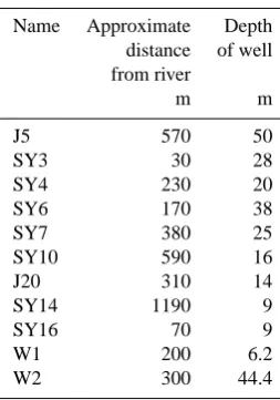
Table 1. The information of groundwater wells.
Name Approximate Depth
distance of well
from river
m m
J5 570 50
SY3 30 28
SY4 230 20
SY6 170 38
SY7 380 25
SY10 590 16
J20 310 14
SY14 1190 9
SY16 70 9
W1 200 6.2
W2 300 44.4
3 Methods
3.1 Data collection
The historical precipitation, shallow groundwater and sur-face water level data were collected from Annual Hydro-logical Report of the People’s Republic of China. In this study, the precipitation and surface water levels were mea-sured daily from Zhongmou and Xinzheng gauging station in the Jialu River basin. The groundwater levels correspond-ing to the surface water were measured at two monitorcorrespond-ing wells (Fig. 1) over the period 1972–1973. The two monitor-ing wells were located at Zhongmou site (W1) and Xinzheng site (W2), 300 and 200 m distances from the river gauging station, respectively (Table 1). The manual measurement fre-quency was six times per month.
3.2 Water sampling
[image:3.595.363.490.79.260.2]L. Yang et al.: Characterizing interactions between surface water and groundwater 4269
Table 3. Major ions and stable isotope concentrations in rain water in July 2010.
Name Date EC T pH HCO3 Cl NO3 SO4 Ca K Mg Na δD δ18O
µS cm−1 ◦C mg l−1 mg l−1 mg l−1 mg l−1 mg l−1 mg l−1 mg l−1 mg l−1 ‰ ‰
SY29 22 Jul 2010 40.3 28.3 – 18.6 1.6 0 11. 5 7.3 4.4 0.8 1.6 −88.1 −12.07
SY41 23 Jul 2010 26.3 – 8.60 24.7 7.7 0 5.3 10.6 1.3 1.8 0.5 −112.2 −15.57
Fig. 3. Major geological formation of the study area (data source: http://www.ngac.cn).
Surface water samples were collected at nine locations (Fig. 1). The groundwater samples were taken from 9 do-mestic wells in the Quaternary aquifer (Table 4). The depths of the wells ranged between 9 m (location SY14 and SY16 in Fig. 1) in Fugou and Xihua counties, and 50 m (location J5 in Fig. 1) in Xingyang, the northwestern part of the investigated area where the surface elevation is approximately 156 m with reference to the sea level.
Surface water samples were typically collected at bridges in the reaches at a depth of about 30 cm using a weighted polyethylene water collector. The existing village-supply wells were selected for sampling groundwater. The 100 ml polyethylene bottles used to store the unfiltered stream sam-ples were pre-rinsed with sample water three times before the final water sample was acquired. All samples were sealed with adhesive tape so as to prevent evaporation. The global positioning system (GPS) was used to locate the sampling locations.
3.3 Water analysis
Temperature, pH value and electrical conductivity of each sample were measured in situ using an EC/pH meter (WM-22EP, Toadkk, Japan). Oxygen concentration and redox po-tential were also determined using a Hach HQ30d Single-Input Multi-Parameter Digital Meter. The field water qual-ity parameters were monitored until these values were stabilized.
The water quality was measured at the Center for Phys-ical and ChemPhys-ical Analysis of Institute of Geographic Sci-ences and Natural Resources Research, Chinese Academy of Sciences (IGSNRR, CAS). All samples were analyzed for major ion composition, including Ca2+, Mg2+, Na+, K+,
SO24−, NO−3, and Cl−. Major cations were determined using
L. Yang et al.: Characterizing interactions between surface water and groundwater 4271
Fig. 4. Shallow groundwater levels in the Jialu River basin based on original source (Yang, 2012). The groundwater level contours (m a.s.l.)
are presented at uneven intervals. Arrows indicated the general groundwater flow.
The normalized inorganic charge balance, NICB, defined as (TZ+-TZ−)/TZ+, represents the deviation extent between the total cations and total anions (Edmond et al., 1995; Huh et al., 1998). It was indicated by Huh et al. (1998) that the measured major ions (Ca2+, Mg2+, Na+, K+, SO24−, NO−3, Cl−, HCO−3) are generally in the charge balance. A few of these water samples showed a charge imbalance with a positive charge excess, or some inversely with a negative charge surplus. The positive charge excess could be related to the fact that no analysis of PO34−was made and the nega-tive charge surplus could be attributable to the lack of NH+4 measurements. However, the chemical analysis results were adopted when the charge-balance error was within±10 % in the study.
Water isotopes (δD and δ18O) were determined at IGSNRR, CAS using off axis integrated-cavity output laser spectroscopy (Model DLT-100; LosGatos Research Inc.) and the method described in Lis et al. (2008). All samples were normalized to internal laboratory water standards that were previously calibrated relative to the Vienna Standard Mean Ocean Water (VSMOW, 0 ‰). Results were expressed as parts per thousand deviations from the VSMOW with ana-lytical precisions of±1 ‰ (δD) and±0.15 ‰ (δ18O).
4 Results
4.1 Water level variations
When the altitude of the river stage is higher than altitudes of groundwater levels in the nearby area, water flows from the river to the aquifer (a losing reach). Conversely, when the altitude of the river stage is lower, water flows from the aquifer to the river (a gaining reach).
At Zhongmou site, the level of the groundwater was higher than that of the river for most of the study period, including the period of the major flood (Fig. 5a). For example, the wa-ter table was, on average 1.6 m higher than the river and up to 3.6 m during the major flood. However, the groundwater was nearly close to the river at the beginning of the flood sea-son. At the Xinzheng site the level of the groundwater was 5.5–7.2 m higher than the river level (Fig. 5b).
4272 L. Yang et al.: Characterizing interactions between surface water and groundwater
[image:8.595.49.286.61.283.2]Fig. 5
Fig. 5. Comparison of groundwater level with surface water level at
Zhongmou (a) and Xinzheng (b). Daily precipitation is plotted in the right y-axis. Locations are in shown in Fig. 1.
4.2 Stable isotopic composition in waters
Stable isotopic compositions in water can be considered conservative and hardly affected by water-rock reactions under normal temperatures (McCarthy et al., 1992; Gat, 1996). Therefore, isotopic variations may occur within the catchment as a consequence of concentration variations in the input such as rainfall and surface water (Kendall and McDonnell, 1998).
TheδD andδ18O values of the surface and groundwater samples collected in July and September 2010 were plot-ted in Fig. 6 with the local meteoric water line (LMWL; precipitation in Zhengzhou; WMO/IAEA, 2010) giving ac-curate information on the input signal. These samples are well distributed along the LMWL, illustrating that surface and groundwater from the shallow Quaternary aquifer most probably originate from present-day precipitation.
Theδ18O values varied from−12.58 ‰ to−3.34 ‰, and theδD values changed from−91.33 ‰ to−35.48 ‰ in JR water (Table 2). Moreover, heavier isotopes were enriched in river water in the upper reaches, which resulted mostly from evaporation form reservoirs where these samples were collected (Fig. 6).
The two tributaries of Suoxu River and Dongfengqu flow into the JR in north and east Zhengzhou, respectively, and the resulting water sampled downstream (J10) should reflect the mixture of the two channels.
The surface water samples obtained in the second sam-pling campaign present a wide range of stable isotopic sig-natures. Isotopic composition of river water was mostly neg-ative. It could be due to precipitation with lighter isotopes.
Signatures of all of these groundwater samples except the sample SY3 remained the same during the flooding event and after the flooding event (Table 4), which indicates that the aquifer seems to be large enough to mask the seasonal iso-topic variation caused by rainfall. Sample SY3 was depleted in lighter isotopes after the flooding event, possibly indicat-ing that the riverbank-aquifer water may originate from a mixing of original groundwater and river water with more depleted isotope values.
4.3 Main geochemical parameters
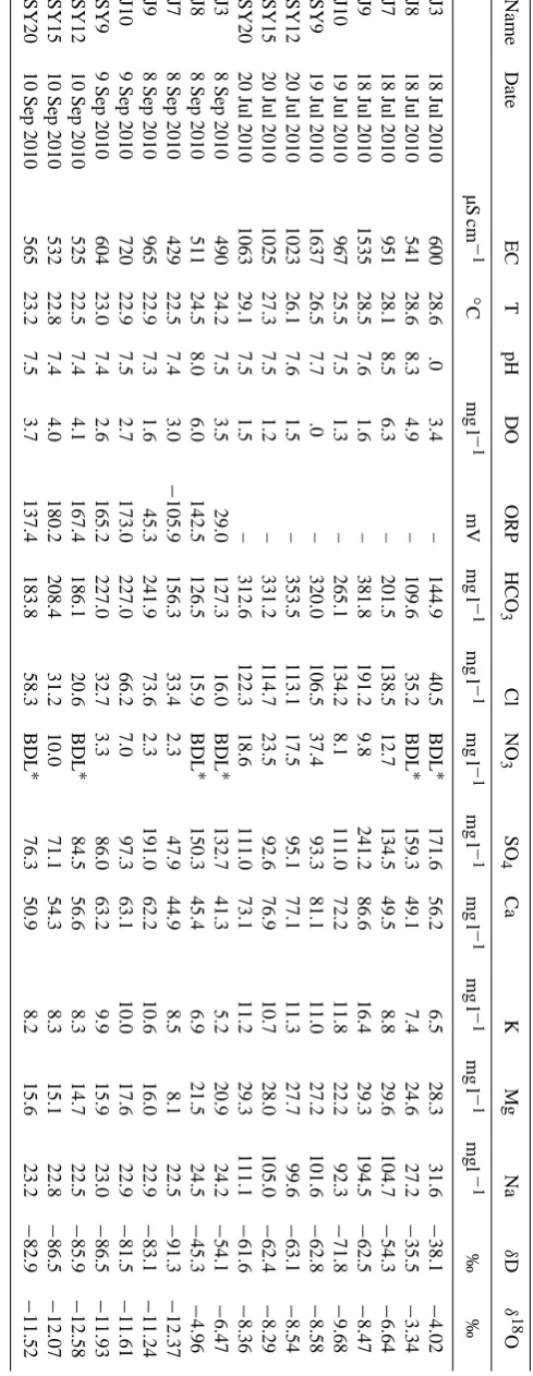
Electrical conductivity (EC) (Table 2) measured in surface water varied from 541 to 1637 µS cm−1 in July and 429– 965 µS cm−1 in September 2010. The former EC reflected the pollutant migration process in the river channel. The high level of EC in location J9 and SY9 was primarily due to samples collected before rain and during the flood peak pe-riod. The levels of EC in location J10, SY12 and SY15 were lower than that in location SY9, which is because the flood peak carrying a large amount of pollutant passed. The latter EC values were significantly lower during post-rain condi-tions, which is likely due to a considerable amount of dilu-tion of ion concentradilu-tion resulting from heavy precipitadilu-tion during this period. EC values in groundwater varied from 608 to 2280 µS cm−1, with the highest values observed in groundwater from Fugou (sample J20). The water temper-ature measured in surface water varied from 25.5–29.1◦ in July and 22.5–24.5◦ in September 2010, which were much higher than the temperature measured in groundwater in both campaigns (16.8 to 21.3◦). Most of the surface water showed
pH values between 7.0 and 8.0, whereas groundwater pH var-ied between 6.83 and 7.52 with no obvious variation during the campaigns. DO concentrations of the surface water and groundwater ranged from 1.2 to 6.3 mg l−1with an averaged concentration of 3.04 mg l−1 and 0.36–7.09 mg l−1, respec-tively. Most part of this study area was found to be under oxidizing conditions with Eh values ranging from−119 to 236 mV.
L. Yang et al.: Characterizing interactions between surface water and groundwater 4273
Fig. 6
[image:9.595.127.462.63.292.2]Fig. 7
Fig. 6. Relationships betweenδD andδ18O in water collected from JRB in July (a) and September (b) 2010.
Results of chemical analyzes of groundwater and surface water samples are shown in the Piper diagram (Fig. 7). In the upper stream water (J3 and J8), SO24− and Ca2+are the predominant ions, with concentrations ranging from 132 to 172 mg l−1 and from 49.08 to 56.17 mg l−1 (Table 2), re-spectively. Chloride is the second anion after HCO−3 over the lower reaches of reservoirs, with the highest concentra-tion being measured in north Zhenghzou during the flood-ing event (191 mg l−1, July 2010). There are many possible sources of Cl−, which may be related to untreated or inade-quately treated sewage and industrial activities. Sodium is the dominant cation of the river water during the flooding event, varying from 92 to 194 mg l−1, whereas, Ca2+ is the dom-inant cation except for north Zhenghzou after the flooding event, varying from 41 to 63 mg l−1. It showed most
vari-ations in Cl−and Na+content due to anthropogenic
influ-ences during the flooding event compared to after the flood-ing event.
The chemical composition of groundwater at SY3 varied from Ca-Na-Cl-HCO3 rich in July to Na-Ca-HCO3 rich in
September 2010. In contrast, the chemical composition of water from other wells did not change significantly during the study period, but the concentrations of major ions var-ied considerably from well to well. For example, ground-water from the area near the Chulou Reservoir is Ca2+ and HCO−3 dominant and is characterized as a Ca-Mg-HCO3water type, whereas groundwater in the lower reaches
Zhengzhou (SY14) is Ca2+ and Cl− dominant and is char-acterized as a Ca-Mg-Cl-HCO3water type. In the
ground-water of location J20, the concentration of K+was as high
as 51.49 mg l−1, which is 32 times higher than the
aver-ages of the other groundwater samples. Furthermore, clear
Fig. 6
Fig. 7
Fig. 7. Piper diagram of major ion chemistry for groundwater, river
water and lake water in the study area.
anthropogenic inputs are indicated in groundwater of loca-tion SY14 and J20 (Fugou County) where high NO−3 con-tents excess the World Health Organization Standard (WHO, 2008) and Chinese limitation value (10 mg l−1calculated as
N) for drinking water (Ministry of Environmental Protection, the People’s Republic of China, 2002).
[image:9.595.313.545.335.535.2]4274 L. Yang et al.: Characterizing interactions between surface water and groundwater
Table 5. Water saturation indices (SI) with respect to calcite in July
and September. The PHREEQC was used to compute the saturation indices.
SI/calcite July 2010 September 2010
Surface water
J3 0.47 −0.19
J8 0.66 0.34
J7 1.03 −0.15
J9 0.64 −0.06
J10 0.37 0.15
SY9 0.65 0.12
SY12 0.61 −0.05
SY15 0.43 0.01
SY20 0.46 −0.01
Groundwater
J5 0.08 0.22
SY3 0.46 0.32
SY4 0.25
SY6 0.3 0.33
SY7 0.51 0.40
SY10 0.28 0.31
J20 0.37 0.29
SY14 0.13 0.21
SY16 0.24 0.28
The surface water showed an oversaturation with respect to calcite (SI = 0.37∼1.03; Table 5) during the flood-ing event, while some of the water was undersaturated (SI =−0.19∼ −0.01; Table 5) after the flooding event. The SI values with respect to calcite indicate that the groundwater is slightly saturated with respect to this solid phase.
5 Discussion
5.1 Anthropogenic sources and impacts on surface water and groundwater
Human activity is one of the most important factors affect-ing hydrology and water quality. Water chemistry of rivers can reflect changes in watersheds, making rivers good indi-cators of land use (Meybeck and Helmer, 1989). Chemical alteration associated with human activity is related to the de-velopment of cities and intensification of agriculture, espe-cially the discharge of untreated sewage waste. Therefore, human activities driven by economic development, popula-tion growth, and urbanizapopula-tion jointly result in alterapopula-tions of river water quality.
The average concentration of sulfate was 8 mg l−1in the rain water, which was far less than that of the water in the upper stream. Although the isotope data that were used showed that the lake water was extremely enriched com-pared to the other water bodies, the increasing of sulfate was
[image:10.595.84.250.105.362.2]Fig. 8
Fig. 8. Major ion concentration/distance from river mouth profiles
for chloride and sodium in the main stream of the JR.
out of proportion to the rain. This would make it clear that the source of SO24−results from the oxidation of uncovered pyrite in headwater areas of the Suoxu River and JR, con-sidering mining in the upstream mountain area (Pang, 1994). Because the reservoir retains river water, the concentration of SO24− is accumulated. Similarly, the average of the con-centrations of Cl− and Na+ were 4 and 1 mg l−1, respec-tively, which were also less than that of the water in the river. The concentration-river distance profiles (Fig. 8) for the two indicator ions (Cl−and Na+) show the pronounced effects of urbanization on the major ion chemistry of the JR. Concentration of Cl− is below 30 mg l−1 in the upper
reaches of Zhengzhou, and then increases by a factor of 4.4 in the urban region of north Zhengzhou. It becomes rapidly diluted over the lower reaches of the city in July. The rea-son is that Zhengzhou is a big city with a population of 4.3×10⁶people, whereas the lower reaches of counties are relatively small with a population of 0.5–0.8×10⁶ people (Henan Provincial Bureau of Statistics, 2011). The untreated sewage waste (average 37 t day−1 between 2007 and 2009) in Zhengzhou was eventually discharged into the Jialu River. Chloride and sodium are major electrolytes in human urine (Kirchmann and Pettersson, 1995) and are therefore concen-trated primarily in waste water. The higher Cl−and Na+in the river could be coming from sewage wastes. Trends in Cl− and Na+after a flooding event are the same as those during
the flooding event. However, the concentration after a flood-ing event is lower than that durflood-ing the floodflood-ing event due to the precipitation.
L. Yang et al.: Characterizing interactions between surface water and groundwater 4275
10 counties growing vegetable in China. In 2009, Fugou had 361 000 rural employees, a total sown area of 144 730 ha, and 120 099 large animals (Henan Provincial Bureau of Statistics and Henan Survey Office of NBS, 2010). To increase crop yield and income, farmers are currently decreasing the use of organic fertilizer in favor of inorganic fertilizers with pro-portions of nitrogen, phosphorous, and potassium throughout agricultural regions of Fugou. This approach has led to losses of fertilizer into groundwater. Potassium concentration (J20) largely exceeds the mean potassium concentrations in drink-ing water, e.g. 2.5 mg l−1in the UK (Powell et al., 1987) and up to 8 mg l−1in Canada (Health Canada, 2008). Those re-sults are probably caused by the use of a large amount of fertilizer.
5.2 Interactions between surface water and groundwater
By synthesizing various types of field data obtained in this study, it is possible to provide a picture of the surface water and groundwater interactions within the basin. Groundwa-ter wells were generally categorized into two groups based on dissolved-solids concentrations and stable isotope values: (1) regional wells, in areas where groundwater did not in-clude water recently recharged from the river (all locations except the SY3 in the basin); and (2) transitional wells, in ar-eas where groundwater was possibly a composite of recharge from the river and water from regional systems during river high flow periods; and was only water from regional systems during river low flow periods (location SY3).
The regional wells ranged from 70 to 1190 m from the river and had water with a constant stable isotopic signature (δD,δ18O) throughout the hydrological cycle, which did not reflect seasonal variations although the river water isotope varied greatly due to precipitation. This illustrates that the groundwater never or rarely received recharge from surface water. Besides, from a conventional hydrogeological survey and comparison surface water with groundwater levels at two sites it is evident that the groundwater feeds the river, perhaps as a result of infiltration from the rain.
The transitional well of SY3, 30 m from the river, seemed to be closely connected to the nearest river water as the groundwater had similar trends of stable isotope signatures and chloride content with the river. The salient features of the isotope and hydrochemistry of groundwater at SY3 are as follows. Before the flood event (July 2010), theδD and
δ18O of water were −57.80 ‰ and −7.54 ‰, respectively. After the flood event (September 2010), the δD and δ18O was found to be depleted. In the same way, the Cl− con-tent in September 2010, was also diluted. That is because the recharge by river water via bank infiltration in Septem-ber 2010, could be characterized by lower Cl−and relatively depletedδD andδ18O signatures.
The composition of groundwater at SY3 in Septem-ber 2010 can be described by a mixture of two possible
sources, including groundwater from the regional system, and river water. The river water and rainwater sources were combined in one as river water because river floods in September 2010 were mainly from the precipitation.
Although one sample of observation seems to be less than satisfactory in detecting groundwater recharge in flooding events, it can provide information on the fraction of river to groundwater recharge for a specific period of time. When these water sources are considered as end members to the groundwater at SY3, it is possible to estimate mixing pro-portions between the waters using a mass-balance approach (Christophersen and Hooper, 1992; Clark and Fritz, 1997; Kendall and Mcdonnell, 1998).
Assuming that groundwater at SY3 in September 2010 was a result of mixing original groundwater (GW) and river water (RW), the following equation can be used to assess the fractional contributions of river water to the groundwater:
f = CS−CGW
CRW−CGW
×100 %
whereCSis the Cl−,δD orδ18O (mg l−1or ‰) of the mixed
water sample (location SY3 in September 2010); CRW is
the Cl−,δD orδ18O of river water (location J9 in
Septem-ber 2010); and CGW is the Cl−, δD or δ18O of original
groundwater in July 2010 that is not influenced by river recharge. Location SY3 in July 2010 was chosen as the orig-inal groundwater end-member because it has not recharged by the river.
The resulting fractional contrition percentages are 60, 61 and 70 % using Cl−,δD and δ18O, respectively. Mixing calculations suggest that the groundwater at SY3 in Septem-ber 2010 was composed of approximately 60–70 % river wa-ter, depending on the tracer employed. This result shows that more than half of water contamination of river water can be into the groundwater if the river water is severely polluted.
6 Conclusions
The Jialu River basin is being faced with environmental pres-sures mainly coming from anthropogenic influences. Hence, it is important to systemically monitor the Jialu River and groundwater to provide detailed isotopic and hydrochemical information for a greater understanding of these impacts on the river and groundwater and how to effectively manage of the basin in the future. The study comprised of EC, tempera-ture, pH, DO, Eh, the isotopes and the major dissolved inor-ganic ions along the Jialu River in July and September 2010. In addition, existing geological data, precipitation data and surface and groundwater level data were included in the anal-ysis. Major findings are as follows.
4276 L. Yang et al.: Characterizing interactions between surface water and groundwater
of untreated or slightly treated waste water. Nitrate and potassium show maximum concentrations in groundwa-ter in Fugou County. These high levels can be attributed to agricultural practices across this region, especially ar-tificial and manure fertilization and animals feeding. 2. All evidence shows that the surface water appeared to be
continuously recharged from the surrounding ground-water (locations J5, SY6, SY7, SY10, J20, SY14 and SY16) throughout the year. In addition, the river was recharged by groundwater at location SY3 in July 2010. The contaminated aquifers discharging to river can re-sult in a long-term contamination of surface water. 3. The transitional well of SY3 seemed to be recharged
by river water via bank infiltration in September 2010. Fractional contributions of the river water to the ground-water were calculated based on isotopic and chemical data using a mass-balance approach. The groundwater (SY3 in September 2010) was approximately composed of 60–70 % river water. This finding demonstrates that the river water contamination can be into the groundwa-ter if the river wagroundwa-ter is severely polluted.
Acknowledgements. The authors are grateful to Major Science and Technology Program for Water Pollution Control and Treatment (Grant No. 2009ZX07210-006) for supporting and financing the research. We would also like to thank Xiting Long (Guilin University of Technology, China), for his assistance in sample collection.
Edited by: A. D. Reeves
References
Christophersen, N. and Hooper, R. P.: Multivariate analysis of stream water chemical data: theuse of principal components anal-ysis for the end-member mixing problem, Water Resour.Res., 28, 99–107, 1992.
Clark, I. D. and Fritz, P.: Environmental Isotopes in Hydrogeology, Lewis Publishers, New York, 1997.
Edmond, J. M., Palmer, M. R., Measures, C. I., Grant, B., and Stal-lard, R. F.: The fluvial geochemistry and denudation rate of the Guayana Shield in Venezuela, Colombia, and Brazil, Geochim. Cosmochim. Acta, 59, 3301–3325, 1995.
Gao, S.: Groundwater Cycle Pattern and Renewability Evalua-tion of Groundwater in the Quaternary aquifer in Henan Plain, Ph.D. thesis, Jilin University, Changchun, 85 pp., 2008. Gat, J. R.: Oxygen and hydrogen isotopes in the hydrologic cycle,
Annu. Rev. Earth Pl. Sc., 24, 225–262, 1996.
Han, X., Wang, X., and Zhou, T.: Analysis of tertiary system water chemical characteristics of Henan plain, J. Jiaozuo Inst. Technol., 21, 357–359, 2002.
Health Canada: Guidance on Potassium from Water Softeners, Health Canada, Ottawa, Ontario, 2008.
Henan Provincial Bureau of Statistics, Henan Survey Office of NBS: 2010 Henan Statistical Yearbook, China Statistics Press, Beijing, 2010.
Henan Provincial Bureau of Statistics: The 6th national popula-tion census bulletin and Henan Provincial Bureau of Statistics, Zhengzhou, 2011.
Huh, Y., Tsoi, M., Zaitsev, A., and Edmond, J. M.: The fluvial geo-chemistry of the rivers of Eastern Siberia: I. tributaries of the Lena River draining the sedimentary platform of the Siberian Craton, Geochim. Cosmochim. Acta, 62, 1657–1676, 1998. Kendall, C. and McDonnell, J. J.: Isotope Tracers in Catchment
Hy-drology, Elsevier, Amsterdam, 1998.
Kirchmann, H. and Pettersson, S.: Human urine – chemical compo-sition and fertilizer use efficiency, Nutr. Cycl. Agroecosys., 40, 149–154, 1995.
Lis, G., Wassenaar, L. I., and Hendry, M. J.: High-precision Laser
spectroscopy D/H and18O/16O measurements of microliter
nat-ural water samples, Anal. Chem., 80, 287–293,2008.
Liu, A., Ming, J., and Ankumah, R. O.: Nitrate contamination in private wells in rural Alabama, United States, Sci. Total Environ., 346, 112–120, 2005.
Lu, D., Huang, W., Li, X., and Li, J.: Correlation of Zhengzhou City economic development and Jialu River Zhongmouchenqiao section water quality, Henan Sci., 26, 1117–1120, 2008. Ma, J., Ding, Z., Wei, G., Zhao, H., and Huang, T.: Sources of water
pollution and evolution of water quality in the Wuwei basin of Shiyang River, Northwest China, J. Environ. Manage., 90, 1168– 1177, 2009.
McCarthy, K. A., McFarland, W. D., Wilkinson, J. M., and White, L. D.: The dynamic relationship between ground water and the Columbia River: using deuterium and oxygen-18 as tracers, J. Hydrol., 135, 1–12, 1992.
Meybeck, M. and Helmer, R.: The quality of rivers: from pristine stage to global pollution, Palaeogeogr. Palaeocl., 75, 283–309, 1989.
Ministry of Environmental Protection, the People’s Republic of China: Environmental Quality Standard for Surface Water, GB 3838-2002, Beijing, 2002.
Pang, C.: Metal and Non-Metallic Mineral in Henan, Henan Educa-tion Press, Zhengzhou, 1994.
Petelet-Giraud, E., Negrel, P., Gourcy, L., Schmidt, C., and
Schirmer, M.: Geochemical andisotopic constraints on
groundwater-surface water interactions in a highly anthropized site, The Wolfen/Bitterfeld megasite (Muldesubcatchment, Germany), Environ. Pollut., 148, 707–717, 2007.
Powell, P., Bailey, R. J., and Jolly, P. K.: Trace Elements in British Tap-Water Supplies, PRD 706-M/1, WRc Enviroment Medmen-ham Laboratory, MedmenMedmen-ham, 1987.
Sophocleous, M.: Interactions between groundwater and surface water: the state of the science, Hydrogeol. J., 10, 52–67, 2002. WHO: Guidelines for Drinking-Water Quality, 3rd Edn.,
Incorpo-rating the First and Second Addenda, Volume 1 Recommenda-tions, Geneva, 2008.
Winter, T. C.: Ground water and surface water: the linkage tightens, but challenges remain, Hydrol. Process., 15, 3605–3606, 2001. Winter, T. C., Harvey, J. W., Franke, O. L., and Alley, W. M.:
L. Yang et al.: Characterizing interactions between surface water and groundwater 4277
WMO/IAEA: Global Network of Isotopes in Precipitation, The GNIP Database, available online at: http://nds121.iaea.org/wiser/ index.php (last access: May 2012), 2010.
Woessner, W. W.: Stream and fluvial plain ground water interac-tions: rescaling hydrogeologic thought, Ground Water, 38, 423– 429, 2000.
Xie, D., Zhao, H., Zhai, G., Ouyang, K., Liu, H., and Yang, S.: On the changes of water quality of Jialu River in Zhoukou region, J. Zhoukou Normal Univ., 25, 68–71, 2008.
Yang, L.: Mechanism of Interaction between Groundwater and Sur-face Water at the Polluted Channel in the Shaying River Basin, Ph.D. thesis, Graduate University of Chinese Academy of Sci-ences, Beijing, 2012.
Zhang, W. L., Tian, Z. X., Zhang, N., and Li, X. Q.: Nitrate pollution of groundwater in Northern China, Agr. Ecosyst. Environ., 59, 223–231, 1996.
Zhang, Y., Tang, C., Song, X., and Li, F.: Behavior and fate of alkylphenols in surface water of the Jialu River, Henan Province, China, Chemosphere, 77, 559–565, 2009.
Zhang, Y., Song, X., Kondoh, A., Xia, J., and Tang, C.: Behav-ior, mass inventories and modeling evaluation of xenobiotic endocrine-disrupting chemicals along an urban receiving waste water river in Henan Province, China, Water Res., 45, 292–302, 2011.