Full Length Research Article
INFLUENCE OF SEDIMENT TEXTURE ON BEACH MORPHODYNAMICS STATE
1
*Haerany Sirajuddin,
2Suriamihardja, D. A.,
3Imran, A. M. and
4Thaha, M. A.
1,4
Department of Civil Engineering, Hasanuddin University of Makassar, Indonesia
2
Department of Physics, Hasanuddin University, Indonesia
3
Department of Geology Engineering, Hasanuddin University, Indonesia
ARTICLE INFO ABSTRACT
Type of beach sediment is very important in determining what the beach looks like, beside waves, tides and wind factors. Different beaches have different types of sediment texture. Beach classification can be usefull coastal planner to group beaches of similar characteristics and behaviours. This paper aims to explain beach morphodynamic states based on sediment texture in Wright and Short method, so this aspect will be considered as one of the an important variable. The study use a method of field study, petrography analysis and using Gradistat software package besides past researches study to examine the coastal sediment and topography features along the beach of Lapakaka and Lumpue at Parepare Municipality also Ujung Lero, Tassiwalie, Jampue, Sibo, Kappe, and Maroneng at Pinrang Regency, South Sulawesi, Indonesia. The result indicate that beaches of Tassiwalie, Jampue, Maroneng and Lapakaka shows sediment texture of coarser sand with ranging from 25.2% to 42.4% so that including in beach mophodynamic state of reflective. Meanwhile, beaches of Ujung Lero, Sibo, Lumpue and Kappe including in beach mophodynamic state of disspative where consist a number of fine sand which range from 38.6% to 48.8%. Especially for Lapakaka beach consist of gravel with composition 41.3%.
Copyright © 2015 Haerany Sirajuddin et al. This is an open access article distributed under the Creative Commons Attribution License, which permits unrestricted use, distribution, and reproduction in any medium, provided the original work is properly cited.
INTRODUCTION
The study of coastal systems evolution is an important issue for a proper coastal management and planning of sandy beaches. For this reason, it is often recommended the use of morphodynamic classification of the beach system in order to forecast changes in beach morphology, when dealing with coastal management. The classification should be based on the mutual interaction of all hydrodynamic and morphological parameters (i.e. wave climate, mean grain size, beach shape) in order to provide a complete description of the physical processes occurring in coastal areas and affecting the beach response (Van Rijn, 1998; Stive et al., 2002 in Lisi et al., 2011). Sandy beach are accumulations of sand lying between modal wave base and swash limit. They are deposited primarily by waves, but also influenced by tides and topography. Their morphology and dynamics should therefore function of their sand size, the breaker wave climate, including height and periode, tide range and major topographic features.
*Corresponding author: Haerany Sirajuddin
Department of Civil Engineering, Hasanuddin University of Makassar, Indonesia
Each of this variable has considerable spatial and temporal variations, resulting in a range of beach types. At the level of an individual beach where sediment size may be assumed constant, temporal change in wave height and period and lunar tidal cycles induce beach response and change. At a regional level, change in both sediment and breaker wave height induce spatial and temporal change, while at global level a wide range of variable combinations and beach response occurs (Short, 1996). The objective of the study is to explain the beach morphodynamic state based on sediment texture of laboratory analysis result and field study. The study will first determine beach morphodynamic in areas Lapakaka and Lumpue at Parepare Municipality. Second, beaches of Ujung Lero, Tassiwalie, Jampue, Sibo, Kappe and Maroneng at Pinrang Regency.
The understanding of beaches is essential to coastal management (Abanades, 2015). In view of the accelerated pace of development of wave energy, a thorough understanding of the effects of nearshore wave farms on beach morphodynamic will soon be fundamental to coastal management. His paper examines the effects with references to the modal state of the beach using an empirical
ISSN: 2230-9926
International Journal of Development Research
Vol. 05, Issue, 08, pp. 5249-5254, August, 2015
International Journal of
DEVELOPMENT RESEARCH
Article History:
Received 13th May, 2015
Received in revised form 08th June, 2015
Accepted 21st July, 2015
Published online 31th August, 2015
Key words:
Sediment texture;
tidal regime. The spatial and temporal change to the modal state of the beach induced by the wave farm are investigated.
Beach Sediment
Beaches are wave-deposited accumulations of sediment located at the shoreline, extends from wave base where waves begin to feel bottom and shoal, across the nearshore zone, though the surf zone to the upper limit of wave swash. In the coastal zone ocean waves are transformed by shoaling, breaking, and swash. In doing so they interact with the seabed, and determine the beach morphology or shape, a process called beach morphodynamics (Short, 2012). All beaches consist of sediment, which can range in size from sand up to cobbles and boulders. The finer sand result in very low gradient (~1o), beaches while cobbles may be stacked as steep as 20o. Most beachles with fine to medium sand have a swash zone gradient between 1-8o. In the mid latitude, most beaches are composed of siliceous or quartz sand grains derived from erosion. In the tropics, coral reef detritus and shell known as carbonate sediment tend to dominate, while in higher latitude physical weathering produces coarse rock fragment and gravel (Short, 2012). Beaches are divided in to the three basic type wave-dominated, tide modified, and tide-dominated based on relative tide range (RTR) with accommodate the range of wave heights, tide range and beach sediment. Wave-dominated beaches consist of three states, namely reflective, intermediate and dissipative. Wright and Short (1984) in Short (1996), use the dimension fall velocity (Ω) to classify three distinctive beach types:
where Hb is the breaking wave height (m), T is the wave peak period(sec) corresponding to the breaking conditions and Ws is the sediment fall velocity (m/sec). Reflective beaches are produced by lower waves (H<0.5 m), occur where Ω < 1, longer wave periods, coarser sediment and cobble/boulder. They consist of a relatively steep beach face (5–20°), with waves breaking by surging and no bar or surf zone. Their dynamic is driven by surging breakers or collapsing over the step. The strong swash in turn build the steep, high beach face. Dissipative beaches occur where Ω > 6 and are characterised by fine sand, high wave energy, and preferably short wave periods, low gradient swash zone, a wide surf zone, containing two to five subdued parallel bars and troughs. Their dynamic is driven by spilling breakers. Intermediate beaches occur when 1 > Ω > 6, moderate to high waves, fine to medium sand and longer wave periods.
Study Area
The study area extends from Lapakaka to Maroneng (3°35'72" – 40 4’ 51”S and 119°30'.59" - 19°37'12." E) along the western coastal tract of South Sulawesi, Indonesia covering about 30 km. Bounded in the northern by Polewali Mamasa District, eastern by Sidenreng Rappang District; in the South by the Barru District and in the west by Makassar Strait. There are two river mouth consist of Saddang River in Pinrang District and Karajae River in Parepare Municipality (Figure 1). Some
which located Sulawesi Island in the center of the Indonesian archipelago, formed by the accumulation of micro plates derived from a variety of sources such as fragments of Asia, Pacific and Australia (Sirajuddin et al., 2014). Since its formation in the Tertiary period to the present, it consequently produces continuous complex geological and tectonic phenomena. Due to the insistence of influence/pressure by the three major plates, it becomes a very vulnerable condition and includes one of the most active islands in the world.
MATERIALS AND METHODS
The field observation and laboratory analysis has been done to complete this study. The purpose field observation is to see the beach appearance both the composition and topographiy. Laboratory analysis is done by petrography observation and for each fraction textural analysis was performed using D50 sieve size. All of sand samples were collected at 8 sandy beaches. Samples were taken at several the shore at locations with different morphological features (e.g. beach face, surf domain, troughs or bars). Samples dried 24 hours in the oven at 90°C and divided into sub-samples for sieving and petrography analysis. Dry sieve net analysis was performed using a series of sieves ranging in mesh size from 0.063 mm to 4.76 mm. Grain size distributions were determined using the GRADISTAT software package.
WsT Hb
RESULTS AND DISCUSSION
Geological coastal conditions (Sirajuddin et al., 2014) in study area can be described as follows.
Coastal Geology
[image:3.595.45.553.51.675.2]The coastal study area is hilly and rugged coastal base, as a result from tectonic formation, geological structure and
irregular shoreline. From the aspects of tectonics, uplift in Lumpue coast characterized by the coastal terrace and uncovering Quaternary coral reefs and also Quaternary alluvial flat, including emergence coast.
Lithology
The rocks found in study area (Sukamto, 1982) consists of lava, volcanic breccia, tuff (Upper Miocene), Quaternary sandstones and alluvial deposits. Lava, volcanic breccia and tuff are trachytic sourced from the eruption of Parepare and Pangkajene volcano (Kaharuddin, 2007) with Lumpue coastal caldera, alluvial and sandstones are Quaternary sediments from the terrestrial erosion processes.
Geological Structure
Geological structure that appear in the study area are join and fault. The joint in the form of open and closed irregular joint, while the fault through Bojo River in the east-west trending and I Karajae River in the north, both are dextral slip fault.
The morphodynamic state of the beaches along the study area can be divided into various types on the basis of their composition/texture sediment, gradient and topography features. The following are descriptions of beach mrphodynamic state based on Short classification (1996 and 2012).
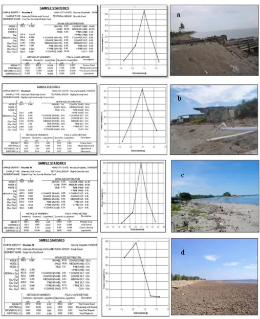
Beaches of Tassiwalie, Jampue, Maroneng and Lapakaka
[image:4.595.66.538.317.485.2]Along the study area, beaches are both sandy and rocky in nature. The fourth this beaches are grouped into the beach morphodynmic state of relective, with sediment texture consist of coarser sand with ranging from 25.2% to 42.4% (Figure 2). Especially for Lapakaka beach consist of gravel with composition 41.3%. In general, this beaches consist of relatively steep, swash dominated and found of mixture of sediment size, it appears that the coarsest material accumulates at the swash zone and forms a coarse steep step. There is no bar, waves break by surging or collapsing.
Fig.3. Fotomikrograph of coarse sand, show occurrences of (a) quartz, (b) rock fragments and (c) shells (carbonate sediment)
[image:4.595.140.458.517.763.2]By petrography analysis using smear slide, the beaches are composed of quartz sand grains derved from erosion of Saddang River. As well as it also found of shells, rock fragmen and gravel (Figure 3). The results of data processing by Gradistat software, showed that Tassiwalie contains of coarse sand 39.4%, medium sand 40,9% and fine sand 3.3%, Jampue consist of coarse sand 39.9%, medium sand 38.1% and fine sand 11.0%, Maroneng contain of coarse sand 42.4%,
medium sand 49.4% and fine sand 2.4%, Lapakaka contains of coarse sand 25.2%, medium sand 6.7% and fine sand 3.0%.
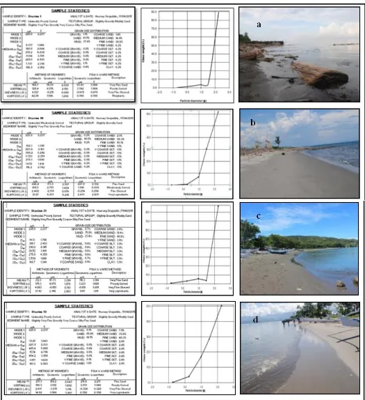
Beaches of Ujung Lero, Sibo, Lumpue and Kappe
[image:5.595.36.561.55.629.2]The fourth this beaches are inclued into beach mophodynamic state of disspative where consist a number of fine sand which
a wide, low gradient swash and consist of at least two bars. Their dynamic is driven by spilling breakers. By petrography analysis using thin section, the beaches are composed of quartz, orthoclase, biotite, volcanic glass, clay mineral and fossil. The occurrences of volcanic glass show that sediment material of beaches sourced from Parepare volcanic rock (Figure 4). The results of data processing by Gradistat software (Figure 5), showed that Ujung Lero contains of coarse sand 1.4%, medium sand 14,9% and fine sand 38.6%, Sibo has coarse sand 2.5%, medium sand 36.3% and fine sand 50.1%, Lumpue consist of coarse sand 2.8%, medium sand 19.4% and fine sand 48.8%, Kappe contains of coarse sand 7.9%, medium sand 33.6% and fine sand 40.3%. Mostly of sediment material of beaches derived from Karajae River and Bojo River.
Conclusions
The beach morphodynamic state reflective and dissipatve in study area described by different of sediment texture and the field appearance of them. The study area has morphology varies, composed of lava, volcanic breccias, tuffs and alluvial, cause of different beach material. Based on sediment texture of sand grain and compare with field data, Tassiwalie, Jampue, Maroneng and Lapakaka beaches including in beach morphodynamic state of reflective, meanwhile Ujung Lero, Sibo, Lumpue and Kappe beaches including in dissipative. The sediment material of beaches shows different because there are different source of rock. The research parameter presented in this paper maybe does not suffice to determine beach morphodynamic state so need furthermore research in order to supporting coastal planner to obtaining more accurate data.
Acknowledgements
The author are grateful to all my promoters which has provided motivation and support in the preparation of this journal. We would also like to thank Kaharuddin, Dr. Sakka, Humayatul Ummah, and student also assistance at Department of Geology and Department of Geophysics Hasanuddin University for help in the field and data processing at various times include. This study is contributed to the research in Civil Engineering Hasanuddin University and for scientific progress.
Abanades, J., Greaves, D., Iglesias, G., 2015. Wave farm impact on beach modal state, Marine Geology Journal 361, 0025-3227/2015 Elsevier B.V, p.126-135.
Goodfellow, B.W., Stephenson, W.J., 2005. Beach morphodynamic in a strong-wind bay: a low-energy environment?, Marine Geology Journal 214, 0025-3227/2004 Elsevier B.V, p.101-116.
Hughes, M.G., Aagaard, T., Badlock, T.E., Power, H.E., 2014. Spectral signature for swash on reflective, intermdiate and dissipative beaches, Marine Geology Journal 355, 0025-3227, Elsevier B.V, 2014, p.88-97.
Jackson, D.W.T., Cooper, J.A.G., del Rio, L., 2005. Geological control of beach morphodynamic state, Marine
Geology Journal 216, 0025-3227, Elsevier B.V, 2005,
p.297-314.
Lisi, I., Molfetta, M.G., Bruno, M.F., Risio, M.D., Damiani, L., 2011. Morphodynamic classification of sandy beaches in enclosed basins: The Case Study of Aliminy (Italy). Masselink, G., Short, A.D., 1993. The effect of tide range on
beach morphodynamics and morphology: a conceptual beach model, Journal of Coastal Research, Vol.9-3, p. 785-800.
Short, A.D., 2012. Coastal process and beaches, Nature Education Knowledge 3(10):15.
Short, A.D., 1996. The role of wave height, period, slope, tide range and embaymentisation in beach classification: a Rreview, Revista Chilena de Historia Natural 69, 589-604. Kaharuddin, 2007. The impact of quatenary tectonic to sea-level and climate global change in indonesia, case study in Dutungan Island, Barru Regency, Engineering Faculty Research Result Proceeding, ISBN 978-979127255-0-6, Vol.1, December.
Pendleton, E.A., Thieler, E.R., Williams, S.J., 2010. Importance of coastal change variables in determinng vulnerability to sea- and lake- level change, Journal of
Coastal Research Vol. 26 No. 1, p. 176-183.
Sirajuddin, H., Surimihardja, D.A., Imran, A.M., Thaha, M.A., 2014. Coastal vulnerability based on tectonics and shoreline change along coastal area of Lumpue Coast South Sulawesi, Proceeding 9th international sympotium on lowland technology, Saga, ISBN: 4 -921090-06-8, p.617-621.