GEOLOGY OF A PORTION OF THE SOUTHERN SIERRA NEVADA OF CALU'ORNIA: THE NORTHERN KERNVILLE QUADRANGLE.
by
Robert W. Webb
A thesis presented to the Division of the Geological Sciences of the Califor-nia Institute of Technology in partial fulfillment of the requirements for the degree of Doctor of Philosophy.
List of Illustrations Figures
Plates Abstract Introduction
TABLE OF CON-rENTS.
Purpose, selection, and scope of the study Field work and Field niethods
Unfinished Work Acknowledgments Geomorphology
Introduction
The Greenhorn Eountains Introduction
Character of the B.ange Drainage
summary
The :Main Fork Valley
Extent, Size, and Character
Characteristics of the River Course The East Side of the Valley
The Origin of the Kern River and Its Canyo11 The r;Ieadowlands
Introduction Boundaries Drainage The Meadows
Introduction Descriptions Types of MeadOVIS
The Sub-sum.mi t rJ;eadows Characteristics Problems in Origin
Consideration of Hypotheses Deformational Hypothesis
Similar I\Ieadows of Other Areas
Meadows of the olancha Quadrangle: The Defonnational Hypothesis
Discussion of' the Glacial Hypothesis General Statement
Evidence for the Glacial Hypothesis The Stages of T:leadow Development in the Area
The Lake stage The Meadow Stage The Trenching Stage Destruction
The Meadow Sediments
Other ~~idenoe of Glaeiation in the Region
Sununary The Headwater Meadows The Domelands Sub-province
Origin of the Domelands The Bartolas Flats
III.
.Page
The Oldlands 41
origin of the Oldlands 42
summary 42
Rockhouse Basin 45
South Fork Canyon 46
South Fork Valley 46
The Origin of the south Fork valley 47
Crestal Upland 50
Meadows 50
Summary 51
Piute Mountains 53
Ki av ah I.lo un t a. in 53
Migration of the Crestline of the Range 54
Summary 54
Correlation of Geomorphic Features 55
Correlation of surface Features vlithin the Area 55
Correlations with Other Regions 55
The Geologic Time Involved 59
Introduction 59
The Time Relations 60
Summary 61
Structural Geology 62
The Kern Canyon Fault 62
Introduction 62
Previous Geologic Investigation 62
Location and Extent of the Fault 62
IV•
.page
Physiographic Evidence 63
The scarp 63
Discordant Profiles of streams crossing the
Fault 63
Line of Cols and Canyons along the Fault Line within the Canyon of the Kern, with Resulting
Trellis Drainage 65
Structural Evidence 67
Rock Difference Adjacent to the Fault 67 Discordant Attitude between the Kernville series
and the Fault 67
Jointing 69
Breccia, I1iyloni t es, and Alterations 69
Miscellaneous EVidence 69
warm Springs 69
Activity of Solution 69
Coincidence of Fault and Intrusive Contact 70
Plan of the Fault 70
Character of the scarp 71
Displacements along the Fault 74
A Fault Line versus a Crustal Rift 74
Relative Time of iviovement along the Fault 76 Explanation of Geomorphic Discordance of the Kern with
the Fault 79
The Origin of the hledian Ridge 82
Possible Southern Continuation of Kern canyon Fault 83
The Durrwood Fault 86
The sacatar Canyon Fault 86
The Greenhorn Fault System Folds
Joints
The Geomorphic History Introduction
The Hypothesis of Hake Hypothesis of the Writer
Introduction
Character of Rejuvenated Surface Stages in the Favored Hypothesis summary
Petrology
The Rocks of the Crystalline Complex Descriptive section
Metamorphic Rocks
The Kernville series Introduction Litho logic Types
~eta-Conglomerate Quartzite
Phy11i tes a.nd l'iica schists Marbles
Meta-Volcanic Rocks Summary
Plutonic Rocks summit Gabbro
Areal Distribllt ion
VI.
Megascopic Description Ivlicroscopic Description sacatar Quartz-Diorite
Areal Distribution lviegascopic Description Microscopic Description
Facies of the Quartz-Diorite Gabbroic Facies
Granodioritic Facies Contaminated Diorite Isabella Granodiorite
General statement Megascopic Description tlicroscopic De script ion Facies of the Isabella Unit
Dioritic Facies
Granitic Facies (Foliated} Pegmatitio Facies
Porphyritic Facies Contaminated Facies Hypabyssal RoCks
Lamprophyre Dikes Granodiorite Dikes Aplite Dikes
Pegmatite Dikes
Silexite Dikes and Veins Interpretive section
:VII.
Page Discussion of Problems of Special Importance in the
History of the Crystalline Complex 123 Summary of Relations between the Crystalline units 123 Attitude of the Kernville series during and before
Intrusion 123
Relations of Intrusives and wall Rocks 129
.Mode of Emplacement 130
Some Hypotheses 130
zones of Weakness 130
Assimilation and stoping 131
Crowding by Force 133
Emplacement in Kernville and Adjacent Regions 133
Summary 135
Remnants of the Kernville series. xenoliths
versus Roof Pendants? 136
Introduction 136
StatllS of the Problem 137
Criteria for the Recognition of Roof Pendants 137 Parallelimn in Plan of Residual Areas of
Invaded Rock 137
Parallelism of structure within Residual
Areas to Regional Elongation 137 Shape of the Residual Masses 137
Host Rock Controls Structure of Invading
Mass 136
Hesidual Areas Composed of Rocks Resistant
to Assimilation 138
Size of the H.esidual Area 139
Summary 140
Special Features of the Plutonic RoOks 140
VIII.
Page Dark Inclusions in the sacatar Quartz-Diorite 140
Description 140
Origin 141
Previous Interpretations 141
Suggested Origin in the Kernville
Region 141
Dark Inclusions in the Isabella Granodiorite 142 Development of Structures in the Intrusive
RoCks 142
Volcanic RoCks 144
Descriptive section 144
Introduction 144 .
Previous Literature 144
Areal Distribution 145
The Bartolas Group 145
Introduction 145
Barto las Creek Unit 145
General Statement 145
Megascopic Description 146
Microscopic Description 146
8100 Hill 146
Megascopic Descriptions 146
Microscopic Description 148
Taylor Meadow Group 150
Introduction 150
Big Table Mountain 150
Little Table I\Iountain 152
IX.
Page
East of \Vhite Dome Flaw 154
Woodpecker Group 154
The Higgerhaad 157
Main Canyon of Kern 157
summary 159
Interpretive section 160
Special Problems of the Volcanic Suite 160 The Quartz in the Quartz-Basalts 160
Introduction 160
Historical Resume 160
The occurrence of the Quartz 160 Hypotheses for the Origin of Quartz in Basalts 162
Granodiorite Xenoliths 163
Size of the Granodiorite xenoliths 163
Shape of the Xenoliths 163
Distribution of the xenoliths 163
Other Features 163
Origin of the Xenoliths 164
Alteration of the xenoliths 166
Lata Introduction of Xenoliths 166
Origin of the Quartz 167
Origin of the coarse-Grained Lava, Facies of the
Taylor Meadows Group 167
Charact.er and Al tera.tion of the surfaces of Extrusion
The Relationships between the Lava Groups The Geologic Time Relations
Age of the Kernville Series
168 168
_
x.
Possible Fossil Remnants Inferences Regarding Age summary
The Age of the Summit G~bbro and the sacatar ~uartz-Diorite Introduction
Early Concepts of the Age of the Gabbro-Diorite Age Relations from the .Literature
Summary
Time of Intrusion of Mafic Units
The Age of the Isabella Granodiorite and rts Facies Age of the Volcanic ROCks
Bibliography
Explanation of Plates in Cover
page . 169
169 173 173 173 174 174 176 176 177 177 180
XI.
Page FIGURES.
Figure 1. Index Map, State of California, Showing Location of
Kernville Quadrangle. • • • • • • • • • • • • 1 2. Location, Greeru1orn mountains • • • • • • • • • • • • 6 3. Location, Main Fork valley. • • • • • • • • • • • 9 4. Gorge of Main Fork of Kern, south of Dry creek,
look-ing sout~ • • • • • • • • • • • • • • • • • • • • • • 10
5. Fault-line scarp along east side of median ridge
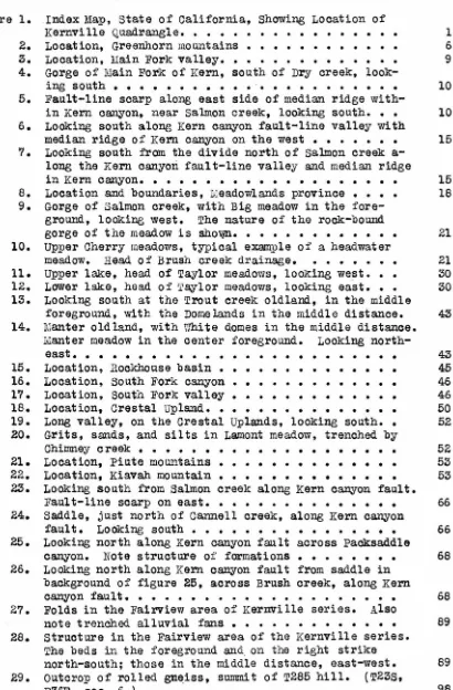
with-in Kern canyon, near salmon creek, lookwith-ing south. • • 10 6. LoOking south along Kern canyon fault-line valley with
median ridge of Kern canyon on the west • • • • • • • 15 7. Looking south from the divide north of salmon creek
a-long the Kern canyon fault-line valley and median ridge
in Kern canyon. • • • • • • • • • • • • • • • • • • • 15 8. Location and boundaries, Meadowlands province • • • • 18 9. Gorge of Salmon creek, with Big meadow in the
fore-ground, looking west. The nature of the rock-bound
gorge of the meadow is Sho~. • • • • • • • • • • • • 21 10. Upper Cherry meadows, typical example of a headwater
meadow. Head of' Brush creek drainage. • • • • • • • 21 11. Upper lake, head of Taylor meadows, looking we~t. • • 30 12. Lower lake, head of T~lor meadows, looking east. • • 30 13. Looking south at the Trout creek oldland, in the middle
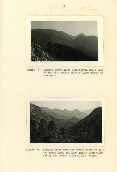
foreground, with the Domelands in the middle distance. 43 14. Manter old land, with Vlhi te domes in the middle distance.
Manter meadow in the center foreground. Looking
north-east. • • • • • • • • • • • • • • • • • • • • • • 43 15. Location, Rockhouse basin • • • • • • • • • • • • • • 45 16. Location, South Fork canyon • • • • • • • • • • • • • 46 17. Location, south Fork valley • • • • • • • • • • • • • 46 18. Location, Crestal Upland. • • • • • • • • • • • • • • 50 19. Long valley, on the Crestal Uplands, looking south. • 52 20. Grits, sands, and silts in Lamont meadow, trenched by
Chimney creek • • • • • • • • • • • • • • • • • • • • 52 21. Location, Piute mountains • • • • • • • • • • • • • • 53 22. Location, Kiavah mountain • • • • • • • • • • • • • • 53 23. Looking south from Salmon creek along Kern canyon fault.
Fault-line scarp on east. • • • • • • • • • • • • • • 66 24. Saddle, just north of Cannell creek, along Kern canyon
fault. Loolcing south • • • • • • • • • • • • • • • • 66 25. Looking north along Kern canyon fault across Paaksaddle
canyon. Note structure of' formations • • • • • • • • 68 26. Looking north along Kern canyon fault from saddle in
background of figure 25, across Brush creek, along Kern
canyon fault. • • • • • • • • • • • • • • • • • • • • 68 27. Folds in the Fairview area of Kernville series. Also
note trenched alluvial fans • • • • • • • • • • • 89 28. structure in the Fairview area of the Kernville series.
The beds in the foreground and on the right strike
north-south; those in the middle distance, east-west. 89 29. outcrop of rolled gn~iss, summit of T265 hill. (T23S,
Figure 30. 31. 32. 33, 35. 36. 37. 36. XII.
Typical outcrop of quartzite. Hear woodpecker meadows. Phyllite from the Fai.rview area of the Kernville
ser-ies. Three-quarters natural size • • • • • • • Typical outcrop of marble in the main valley of the Kernriver. (T22S, R32.E:, sec. 30.) • • • • • • • • •
and 34. Tourmaline concentrations in quartz-mica schists from the Big Pine meadow area of the Kernville series. Represents the most intense pnewnatolytic ac-tion found in the region. Three-quarters natural size. Typical biotite-rich phase of the Summit gabbro, from the gorge of Trout creek. Three-quarters natural size. Typical quartz-diorite of the sacatar unit. From the head of Sacatar canyon. Three-quarters natural size •• Dark inclusions in Sacatar quartz-diorite. Head of Sac at ar canyon. • • • • • • • • • • • • • • • • • • • Sacatar quartz-diorite (coarse), with fine-grained in-clusion. Near Kennedy meadows. Two-thirds natural
Page 96 101 101 102 105 106 113
size. . . • . . . . 113 39. Typical Isabella granodiorite. i'Jote the uniform
med-ium grain. Hear Big Pine meadow. '.rwo-thirds natural
size. . • . . . • . . . • . • • . . . . 115 40. Granitic facies of Isabella unit. Foliation less
marked in photograph than in the field. Three-quarters
natural size. Sirretta pass. • • • • • • •. • • • • • 119 41. Granitic facies of Isabella granodiorite. Highly
weathered. Near Round meadow. Three-quarters natural
size. . . • • . • . . • • • • • • • • • . • • . • • • 119 42. Coarsely foliated phase of Isabella granodiorite.
This has the composition of a granite. Near Big
mea-dow. Three-quarters natural size • • • • • • • • • • 120 43. .An unusual porphyritic phase of the Isabella unit.
orthoclase phenocrysts are present. Durrwood meadows.
Three-quarters natural size • • • • • • • • • • • • • 120 44, and 45. Inclusions of the Kernville series in
Isa-bella granodiorite, on Brush creek, near Burton camp. Attitudes within the inclusions parallel those of the
parent mass, about one-quarter mile to the east • • • 127 46. Granodiorite of the Isabella unit, from Cherry hill.
Taken from the west contact with the quartzite of Cher-ry hill metamorphic area. Sphene percentage in the specimen above is about eight per cent. Sphene is
outlined in the specimen. • • • • • • • • • • • • • • 132 47. flaty flow structure in quartz-basalt of Bartolas
creek group, Bartolas flats • • • • • • • • • • • • • 147 4S. :Pumiceous hornblende trachyte of 6100 hill, Barto las. 149 49. Big Table mountain, looking north from Bartolas flats. 151 50. Big Table mountain as seen from south end of Long
val-ley, looking west across the canyon of the south Fork. 151 51. Looking northwest across Black mountain flow, as seen
from summit of I:.ittle Table mountain. • • • • • • • • 153 52. · The Woodpeclcer flow, looking north. The Higgerhead in
the far distance. Note granodiorite-lava contact in
XIII.
page Figure 54.
55.
The Niggerhead, looking from the north. • • • • • • • 158
56.
57.;
58.
Flows of the main valley of the Kern river. Looking west across the river. on boundary of the Olancha
quadrangle. • • • • • • • • • • • • • • • • • • • • • 158 A quartz bleb in the basalt of the Bartolas creek
group, Bartolas flats. About five miles due north of
Onyx, Cali f'ornia. • • • • • • • • • • • • • • • • • • 161 Inclusion of granodiorite of Isabella unit in olivine
basalt of the Niggerhead. Note the tension cracks radi-ating from inclusion. • • • • • • • • • • • • • • • • 165 Graptolite-like rods in the Kernville series of the
Mine area .. • • • • • • • • • • • • • • • • • • • • • 170 59, and 60. Incrustations on marble in the Kernville
series, Ivline area. · Possible organic remains. one and one-half miles east of Rockhouse basin, junction of Fish creek and South Fork of the Kern river. • • • • • • • 171
PLATES.
Plate I. Round meadow, on headwaters of Brush creek, showing grassy levels, typical of upland meadows of Meadowlands
province. • • • • • • • • • • • • • • • • • • • • • • 20 II. Looking south aorqss Big meadow. This is the largest
meadmv of the Kernville area, and is an excellent
ex-ample of t4e meadow stage of meadowland development • 31 III. Looking southeast across upper Smith meadow, with 7705
dome in background. Notice how alluvial materials are encroaChing upon the meadow surface. such gravel de-posits are pro~ably followed by a new grass growth,
which, again, is erased by gravel encroachment. • • • 33 IV. Gravels in lower Smith meadow. Notice coarse
conglom-eratic sands, and fine organic mud layers. Visible
only in trenched stage of meadow destruction. • • • • 34
v.
Granitic slopes of Trout creek gorge, shmving residualboulders which simulate erratics. Notice character of
dome slopes. LOoking northwes~ • • • • • • • • • • • 37 VI. Headwater meadows on Cherry fork of Br~sh creek. Notice
skunk cabbage, and profuse floral growth. Taken in
.August, l. 935. • • • • • • • • • • • • • • • • • • • • 39 VII. Giant dome east of Smith meadow, with meadow in
fore-ground.· Note exposed sediments • • • • • • • • • • • 40 VIII. Looking northeast across Trout creek oldland, showing
amount of dissection of oldland surface >tith residual
boulders. Bald mountain in the background. • • • • • 44 IX. Map show:lng location of Kern canyon fault • • • • • • 64
X. Fault-line scarp along Kern canyon fault, at salmon creek. salmon creek falls are seen in the pioture.
Note notch cut by stream at crest of soa.rp. • • • • • 72 XI. Diagrammatic east-west profiles across I<:Tain Fork of Kern,
-Plate XII. XIII. XIV. x:;. XVI. XVII. XVIII • XIX.
xrv.
Intrusive relations between sacatar quartz-diorite and Isabella granodiorite, showing Isabella dikes
cross-cutting quartz-diorite. Looking west from south end of Long valley. East of \TJhi te dome flows on right.
.page
Notice the marked parallelism of the dikes. • • • • • 124 Panorama view from Bald mountain (Olancha quadrangle),
looking southeast. In west center foreground can be seen 'Noodpecker lava flow, occupying small hill, with bold, east-facing outcrops. In center, 'l'rout creek oldland, lying north of the Domelands, which are seen in the middle distance. The flat-topped summit in the center background is Sast of \Vhite dome lava unit. Chimney peak in the east background. Total distance
of view, east to west, twenty-five miles. • • • • • • 155 Panorama view. on south (left) is seen the Rockhouse
basin, with canyon of south Fork of Kern in background. The Domelands sub-province of the lieadowlands occupies
the center background. The center foreground and north (right) foreground pictures the Trout creek old land,
with the junction of Fish creek and South Fork of the
Kern in the central foreground. The high Meadowlands surface rises in the north background. Bald mountain is seen on the northern margin. Panor~na view of twenty-five miles. • • • • • • • • • • • • • • • • • • • • In Cover. Panorama view. Looking west from summit west of
nurr-wood meadows, aero ss the drainage of Brush creek,
to-ward main valley of the Kern. In the background, are the Greenhorn mountains. The main valley of the Kern lies just toward the observer from the Greenhorn range.
Between observer and main Kern valley lies the median
ridge east of which passes the Kern canyon fault, whose
fault-line valley can be seen in center foreground. Burton camp area of the Kernville series occup~es
cen-ter hill in foreground. Total extent of panorama, twenty miles. ~lavation of camera, 8950 feet • • • • ~ •• In cover. Topographic map of the Kernville quadrangle, showing
physiographic subdivisions of area studied. • • • • In cover. Geologic map of Kernville quadrangle. • • • • • • • In cover.
Geologic cross-section of Kernville quadrangle. • • In cover. "Kern Canyon Fault, southern Sierra navada." A
paper presented by Robert
w
.
Webb, to the JOl.lrnal of Geology, which embodies in part the studies of thex:v.
ABSTRACT.
The northern Kernville quadrangle lies on the great central plateau of the southern Sierra Nevada in Tulare~ Kern, and Inyo counties, California. It comprises about 600 square miles.
Geomorphically, the area consists of a great interior platform, bounded on the east by the Sierran escarpment and Sierra Nevada fault, and on the west by the Main Fork of the Kern river. The region is divisible in-to nine geomorpJ;lic provinces, each v;ith distinct characteristics. From west to east, these are: (a) the Greenhorn mow1tains, a range averaging 7000 feet in elevation, whose SWTh~ts are remnants of an ancient erosional level, (b) the Main Fork valley, a pronounced north-south valley of 3000 foot depth, traversing the entire quadrangle, (c) the Meadowlands, a high, rolling old-land, rernnant of an old erosional surface, (d) the south Fork canyon, (e) the Rockhouse basin, (f) the Crestal Upland, which marks the eastern crest of the Sierra Nevada, (g) the south :l!'ork valley, a wide, alluvia ted east-west valley, which bisects the area in an east-·west direction, (h) Kiavah mountain, and (i) Piute mountain. The origin of each of these subdivisions
is discussed. It is show·n. that a complex series of' events produced the pres-ent geomorphic featlll·es. The region has undergone l)la.nation, rejuvenation in at least two epochs, and subsequent erosion to the present time. A geo-morphic his tory attempts to harmonize all recorded events.
Structurally the region contains the important Kern Canyon fault, which parallels the Main Fork of the Kern for a distance of more than fifty miles, although not strictly coincident with it. It is sho\vn that the Kern Canyon fault is of very ancient date, probably pre-Pliocene, also that a high fault-line scarp is eroded along the Kern Canyon fault. Evidence is p re-sented to explain the discordance of the Uain Fork of the Kern river vvith the fault. It is suggested that superposition by alluviation prevented the river from taking a course alo1~ the fault, as the stream was revived.
Petrologic and field studies in the area show the following rock units to be present:
(1)
a series of metamorphic rocks of probable Carbon-iferous age, classed as the Kernville series, composed primarily of quartz-ites, phyllquartz-ites, schists, and roorbles; these are invaded by (2) an horn-blende-gabbro to biotite-gabbro, which is closely associated with (3) a quartz-diorite, which invades the gabbro. The date of emplacement of these units is suggested as late Carboniferous. (4) The Isabella granodiorite, varying to granite, invaded all the other formations, and is the final im-portant intrusive unit. This invasion probably accompanied the major diastrophic disturbance of the Sierra, generally set at late Jurassic toearly Cretaceous. Tertiary and Quaternary lavas preserve erosional surfaces formed across the crystalline units. some swamp and. lake deposits, together with present and older alluvium, complete the IJetrologic sequences.
1.
Figure 1.
San Francisco
e
Bakersfield2.
INTRODUCTION.
Purpose, selection, and scope of the study.
The study of the northern Kernville quadrangle as a sample area
of southern Sierra Nevada geology was undertaken to provide basic material for a thesis for the degree of Docto~ of Philosophy in Geology at the Cali-fornia Institute of Technology. The problem was suggested by Professor
w
.
J. Miller, of the University of California at Los Angeles. The thesisconsists of a complete treatment of the general geology, with special
em-phasis on petrology and petrologic problems.
Field work and Field Methods.
A reconnaissance of the general region was made in the fall of 1933;
work was continued at intervals throughout the spring of 1934. Detailed work on the areal map began in the summer of 1934, and was continued in the
swnmer of 1935. Subsequent trips were made to the region in the winter of
1935-36, and fall 1936. In all, over nine months were spent in active
field work.
In the summer of 1934, a base camp was established on Kennedy mea-dows, on the South Fork of the Kern river. (Plate XVI.) This base
camp
offered ready accessibility to the heart of the area, Rockhouse basin and the Domelands. In the.summer of 1935, a base camp was established on Horse
meadows, on ~he headwaters of Salmon creek. sub-base camps were occupied for various lengths of time at Taylor meadows, Bartolas flats, RoCkhouse
3.
A three weak rapid reconnaissance survey of the Olancha quadrangle
was made for the purpose of comparing geological problems in it and the
Kernville region.
On the geologic map accompanying this report, the geology of Tulare
and Inyo counties is by the writer; that of Kern county, modified, after
w.
J. Miller. (See map in pocket.)UnfiniShed Work.
In all, three-fpurths of the area of the Kernville quadrangle has
been mapped. The completion of the map, accompanied by a survey of the
mineral resources of the quadrangle is soon to be finished by W. J. Miller,
of the University of California at Los Angeles, and the writer, who expect
to publish this survey in the near future. It has also been planned to carry on further investigations of the gepmorphology, and of the volcanic
4.
ACKNOWLEDGMENTS.
In the completion of a study of this type one contacts many per-sons who have extended courtesies in the course of the v.ork. To all of these the writer expresses his appreciation.
In particular, the writer wishes to thank all of the members of the staff of the Division of the Geological Sciences of the California Institute of Technology for making the presentation of this work possible. Special thanks is,due Dr. Ian Campbell, Associate Professor of petrology, who gave hours.of his time in aiding all phases of the work, and under whom the ma~or work was conducted. To Dr. J.p. Buwalda, Professor and
Chairman of the Division of the Geological Sciences, the writer owes the privilege of conference on the thesis, and related problems, and for
con-stant advice during his stay at the Institute. To Dr. George H. Anderson, Curator of Geology at the California Institute, and former colleague of the writer, he owes thanks for critical and friendly advice offered on many of the thesis and general problems. The entire faculty of the Division, and numerous graduate students, have aided by discussions and suggestions.
To Dr.
w.
J.
Miller, Professor and Chairman of the Department of Geology of the University of california at Los Angeles, and colleague ofthe writer, he owes ~he suggestion of the problem, and thanks for constant advice and enoouragment, both in the field and in the preparation of this manuscript.
Dr. Catherine Campbell read the entire physiographic and structural sections of the thesis, and offered many excellent suggestions on its
5.
To Dr. F. E. Matthes, of the United states Geological survey, the
writer owes thanks for a long conference on the general problems of the
Sierra Nevada, with which Dr. Matthes is partic~larly familiar.
Mr. Robert p. Bryson, graduate student in the Division of Geological
Sciences of the California Institute, accompanied the ~~iter d~ring two
field seasons, and contrib~ted inval~bly to the preparation of this
manu-script and to the problems and their sol~tion in the region. In addition,
most of the photographic work of the thesis was done by Mr. Bryson.
The writer was assisted in the field in the summer of 1935 by
Mr. Thomas Donlon and :Mr.
w.
Ross Cabeen, st~dents in the Department ofGeology of the university of California at Los Angeles.
Many residents of the area offered assistance in the field work.
In partic~lar, thanks are d~e Mrs. Cliff Willoughby, of the Porter Ranch,
Brown, California; and. to Mt'· Char~es Andress, of Weldon, California.
Finally, the v~iter wishes to thank his colleag~es, Miss. Myrta
Lisle McClellan, Assistant Professor of Geography; Dr. FrederiCk
c.
Leonard, Associate Professor and Chairman of the Department of Astronomy; and Dr.Joseph M~rdoch, Assistant Professor of Geology; all of the University of
California at Los Angeles, for constant mental stim~lation and friendly
6.
GEOMORPHOLOGY.
Introduction.
The Sierra Nevada are, broadly viewed, a great geomorphic province
of homogeneous form. Their simplicity was early recognized by Le Conte
(1889, p. 261) when he showed them to be a great tilted fault bloCk, in
whiah he recognized complications that have since been much investigated.
The southern Sierra, although simulating this simplicity, is not truly a
tilted bloCk, but, as has been pointed out by Miller (1931, p. 333), is a
horst-bloQk of rather simple form, w1 thout westward tilt.
The geomorphic investigations conducted by the writer have led to
subdivision, description, and interpretation of
a.
number of geomorphicprovinces within the region. Although investigated in detail only within
the northern Kernville quadrangle, these provinces have been traced north
and south for sufficient distance so that interpretations of the
geomor-phology apply to most of the southern Sierra.
The Greenhorn Mountains.
GEOMORPHIC DIVISIO\'JS - · ..
--
.. - ... --~ ..Introduction.
From the San Joaquin valley
on the west rising through a
ser-ies of foothill steps, occur a
group of north-south sub-parallel
ridges that are probably separated
by faults. (Hake, 1928; Miller,
1931~ These ridges, from twenty
to forty miles in length, become
7.
progressively higher toward the east. The easternmost of these ridges is
called the Greenhorn mountains.
Character of the Range.
The fault block character of this range was suggested originally
by Lawson (1906, p. 399), and later by Hake (1926, P• 1026) and Miller
(1931, p. 335). Hake says:
"The southward continuation of this scarp [a scarp previously described in the Kaweah area] is the steep western flank of Greenhorn Mountain, which rises precipitously some 2,000
to 4,000 feet above the a.l,luviated vaU.ey of Poso Creek, which parallels the base of the mountain. The general configuration of this
slope suggests that it is an eroded fault-scarp, and the spurs which lie between the young s~reams now dissecting it are interrupted by steplike declivities that stand approximately in line, suggesting distributed faulting."
The general elevation of the Greenhorn mountains is about 8000
feet, With minimum elevations of 5000 feet in the southern part.
Dissec-tion of the east sl,ope of the range decreases the boldness of the mountain
block, which gives the observer the idea. that this block is of subordj,.na.te
importance as compared to adjacent uplands.
To the south, the Greenhorn mountains merge more or less with the
lower heterogeneously grouped ridges and valleys of the Tehachapi
moun-taina. To the north, they
are
absorbed by the more complex areas west ofthe Great Western divide.
Drainage.
The western drainage of t.he Greenhorn mountains is into the san
8.
Geomorphically important east flowing streams draining the Greenhorn bloak are, from south to north, in the area of detailed study, Bull Rwn, Tobias, South, ru1d Dry creeks. All have steep uniform profiles, are of consider-able ~ength, but merge into the Main Fork valley with strikingly di~ferent topography and structure.
Bull Run creek, the longest tributary, enters the Kern five miles north of Kernville. It is a permanent stream, of steep gradient, entering the Kern at accordance; it flows from the r.ange in a valley which rapidly widens toward the point of confluence with the master stream. A large al-luvial fan, deposited by the stream in a previous stage, is trenched near the point of juncture.
Tobias creek has a Shorter, steeper course than Bull Run. It en-ters the Kern accordantly twelve miles above Bull Run creek. It has a uniform profile from head to mouth, flawing in a distinct V-5P~ped canyon. Tobias creek, similar to Bull Run, has trenched an alluvial fan at its
junction with the Kern.
Four miles north of Tobias creek enters south creek, which flows in a sharp V-shaped canyon from the crestal backland in a northward and then eastward course. Its gradient is in distinct contrast to that of other tributaries of the Kern. It is steep in places, sluggish in others where temporary base levels have been established. rts confluence with
the Kern is accordant.
9.
SUTlllilary.
The Greenhorn mountains are a mass of granitic rocks, undergoing
rapid stream erosion, in late youth to early maturity in a second cycle
of erosion. The remnants of the first cycle are preserved in the flat-topped summits of the highly dissected block.
The ~ain Fork Valley.
Extent, Size, and Character.
The valley or canyon occupied by the Kern river extends in a north
and south direction through the central and southern Sierra for more than
GEO'.i..,R?IIIC DIVS101,!S
Location, Main Fork Valley. (Figure 3)
one hundred miles. Remnants of an
earlier cycle valley are preserved
along most of its length. The area
of detailed study includes about
twenty-five miles of the canyon.
Of the course of the Kern w.i thin the Main Fork valley, Olmsted ( 1901, p. 14), in a reconnaissance paper
on the Kern river basin says;
"The length of Kern River from King [s] River summit, on
its main fork, to the mouth of the canyon above
Bakers-fie~d is 118 miles. The channel is in granite [and metamorphic rocks], a,nd, With the exception of a
few drops in the lower reaches of the stream, the grades are fairly uniform. In the 62 miles above Kernville the stream falls 5,600 feet, and in the 48 miles below Kernville it falls about 2,100 feet •11
10.
Figure q,. ti-o.rge of lain Fork of
Kern, south of Dry
creek, looking south.
Figure 5. Fault-line scarp along east side of median
11.
the mouthes of the larger tributaries. North and south of Kernville, a temporary graded reach has been established above the junction of the south Fork of the Kern, where aggradation has occurred. Here the canyon has its maximum width.
The canyon in which the Kern river runs does not comprise the en-tire width of the Main Fork valley. Within the valley, east of the river itself, and on the east side only, lies a median ridge which rises as high as 6500 feet, fully 3000 feet above the average elevation of the canyon floor. This median ridge is separated from the true boundary of the Main Fork valley province by a line of canyons, out by minor tributaries of the Kern river. (Figure 7.) The line of canyons, with intervening east-west divides, runs the enti,.re length of the east s.ide of the valley from Kernville to the confluence with the Little Kern river about thirty-five miles to the north. The eastern wall of the line of canyons rises as a bold west-facing front, marking the western boundary of the Meadowlands province.
Characteristics of the River Course.
At the point at which the river enters the Kernville quadrangle, it is running in a roOk-cut, rock-floored gorge, fully 400 feet deep, in massive granodiorite. _ Less than one-quarter mile from the boundary of ~he quadrangle, the first tributary stream, Dry creek, join$ the Kern from the west. The path of the Kern above Dry creak is roughly north-northeast
12.
between the granitic rocks and their facias, and the Kernville series (Miller, 1931, P• 335) of complex metamorphic rocks. After crossing the contact, South creek enters £rom the Greenhorn mountains. At the south creek junction, the Kern turns N450W-S45~, (parallel to the strike of ~he Kernville series) and, following this direction £or a very short distance,
Changes to an east-west course, even trending somewhat northeast; in the course of less than one-half mile, it again flows north-south until it reaches Bru~ oreelc, one of the major af:fluents of t,he Kern, and one of the major streams draining the Meadowlands province.
From the Brush creek confluence, the river follows a meandering course, first parallel to the structure o£ the Kernville series, then across it, finally emerging again into the granitic terrane where Tobias creek joins the Kern £rom the Greenhorn mountains.
:From Topias creek southward to Kernville, all tributary streams from the west, and some from the east, sho\'1 the same general character-istics. A general statement regarding the western tributaries was made by Lawson (1906, p. 403). He says:
"Purs\ling now our observations up f!:rom Ke:rn-Yille northward; the description above is £rom north to south] the Kern River above Kernville, we find the stream flowing in a profound but re-markably straight canyon. The general trend of the canyon is much more nearly a straight line than is the course of the atrea.m mich flows in it. on the west side o£ the canyon the crest of the mquntains [Greenhorn] is in general about ten miles back from the river. Numerous tribu-tary stre;;!ms enter from this side and all of them, ·as far as Tobias Creek, twenty miles above Kernville, have built up huge alluvial cones which indicate a marked lack of accordance
13.
Four miles below Tobias creel~, from the east, enters Salmon creek,
the major tributary which emerges directly from the I'IIeadowlands. This stream enters the river at accordance, but it is extremely oversteepened in gradient in the lower part of its course; it shows no evidence of al-luvial fan accumulation at the point of confluence with the Kern.
Several miles south of Salmon creek, Bull Run creek joins the Kern from the west. Here the influence of the graded reach at the junction of the Main Fork and the South Fork of the Kern is apparent, and the Kern is a sluggish stream more or less braided, flowing on a large flood plain.
A generalization strikingly applicable to the drainage relations of the Main Fork province and the adjacent ones, is that, from the Green-horn mountain side many small tributaries, closely spaced, enter the Kern, while from the Meadowlands province, widely spaced tributaries of
consider-able si~e enter. This is due to the median ridge which concentrates the streams entering from the eastern upland, diverting them along the line of saddles and caeyons which is sub-paraUel to the Kern.
The East Side of the Valley.
As pointed out by Lawson (1906, p. 504),
''The geomorphic features of the east side of the Kern Canyon from the vicinity of KerAville to the mouth of the Little Kern are in remark-able contrast to those of the west side. In general the east side of the canyon is more pre-cipitous than the west side, and it appears to be the edge of a high uneven plateau. @alled in this paper 'the Meadowlands'_;) The streams are shorter and frequently fall in cascades over the steeper portions of the canyon wall in notches of no great depth. The Kern in the first twenty miles of the stretch under consideration is crowd
14.
These facts in themselves i1micate a rather strik-ing contrast in the geomorphic aspects of the two sides of the ca~on, but the most notable feature of the east side and one which is en-tirely absent on the west side, is a series of high and prominent ridges and butte-like peaks which are arranged along the canyon side in an almost straight line. These ridges and buttes extend along the whole length of the c~on from near Kernville to the Little Kern. Qlbout thirty-two mi las~ They lie within the canyon and reach
in general from about one-half to two-thirds the height of the canyon wall, and they are separated
in each case from the main canyon wall by a de-file or col which is generally several hundred feet lower than the summit of the ridge or butte.
[The line of canyons and saddles referred to abovej Between these ridges or buttes flow transversely
the affluents of the Kern from the notches in the main canyon wall. The entire series present the appearance of a continuous ridge, separated from the main canyon wall by an equally continuous
~rrow defile, which has been dissected by the affluents of the Kern which now pass through it."
(Figures 6 and 7.)
One or two supplementary remarks are necessary to complete the
pic-ture. As the lateral tributaries of the Kern anerge £rem the eastern
up-land and flow down the edge of the valley wa.ll, they are joined by lateral
streams flowing along the defile. :fila.ey- of these laterals do not flow
ex-actly parallel to the defile, but at a slight angle to it. Thus the
drain-age is of crude trellis pattern.
Where streams cross the defile and the ridge west of 1 t, they
deposit alluvial mate~ials behind the median ridge and in the defile in
the form of large alluvial fans, which are extremely blunt at their
west-ern margins where they impinge upon the median ridge; they taper rapidly
toward the escarpment at the east edge of the c~on. This detritus is
thick at the base of the median ridge, and thin at the margin of the
es-carpment. The material is coarse, and unsorted. Fans showing this relation
15.
Figure 6~ Looking south along Kern canyon iaul~-~:~~
valley with median ridge of Kern canyon on
the west.
F1gure 7. Looking south from the divide north of Sal-mon creek along the Kern canyon fault-line
16.
Breccia creek; along Brin and Packsaddle creeks to the south, and along Salmon creek, also along the next southward tributary from the east (called here Siphon creek) where the defile and median ridge are subordinate due
to a decrease in height of the median ridge. This decrease in height of the ridge causes Siphon creek to extend its fan into the Main canyon and Kern channel, thus leaving no differentiation of defile fan and river fan. FUrther south, Cannell, and to a lesser extent Cowell creek, shows the same features.
Thus, it may readily be seen t:tlat the valley of the Kern, at least in the area of detailed study, shows physiograph~c features that well justify its assignment to a separate geomorphic province.
The Origin of the Kern River and Its Canyon.
Examination of any map of the Sierra Nevada brings out at once the striking discordance of the rivers of the southern Sierra Nevada, especially the Kern, with those of the central and northern part of the range. This discordance was commented upon by Drake (1897, p. 570). He says:
11The Kern River is the first to break the
gen-eral westward course and flow south for most of its lengih before turning toward the
Cali-fornia Valley."
This discordance may ha,ve been developed in one of two stages in the geomorphic cycle. The southern trend of the stream lines may have been established in the Neva.dian1 range, and upon rejuvenation by faulting to initiate the present form, the Kern, and other •trea.ms, may have main-ta.ined their courses; in other words, a.n inherited drainage. or, the drainage pattern may have been established in the early stages of deform-at ion which produced the Sierra, either by a. southward t i1 t, a. structural
1
17.
weakness, or a combination of these. Yet a third hypothesis might involve a combination of factors produced in both cycles.
The evidence available is meager. The writer agrees with Drake ( 1897, P• 570), and believes that the drainage of the Kern basin was well established, possibly along the Kern canyon fault, with drainage basins well defined, before the inauguration of the present range. This would
indicate inheritance of form from the Nevadian cycle, in whiCh a southern course of the Kern was well established. This hypothesis is strictly ten-able according to the views of Lawson {1904, P• ~6~), who points out that the eastern part of the Nevadian range was reduced to a surface of moderate relief, not a peneplain, which had greater relief in the south than in the north.
The concept of long established southward drainage is supported by ( l) the benchlands of an earlier cycle preserved high up on the Kern can-yon margins, (2) the fault-line scarp, to the east of the river, which was eXhumed by the river after planation of the drainage area, and (~) the seemingly ancient date of the Kern canyon fault (see P•
7e).
Southward tilting during rejuvenation at the time of initial de-formation of the Sierra Nevada is not essential in maintaining the south-ward flow of the Kern, if. the southsouth-ward drainage was established in the Nevadian cycle. Howev.er, the amount of downcutting accomplished by the Kern in the period of time since the inauguration of the sierran cycle,
strongly suggests impetus added by a south~rd tilt at the time of the in-itial Sierra defo~ation. This idea is supported by the observations of Miller (19~1, P• ~~4), when he states that
18.
@he :Meadowlands and Greenhorn provinoesJ The southerly courses of the two main forks of the Kern River • • • • are believed by the writer to be direct responses to this southerly tilt of the old upraised surface."
Any hypothesis which attempts to integrate the history of the
geo-morphia features of this region must adequately account for the discordant
drainage of the Kern.
The Meadowlands.
rntroduct ion.
The Meadowlands province is the largest physiographic subdivision
in the area. It contains the highest elevations, and the greatest
diver-sity of physiographic form. Described under this province are three
sub-provinces: the Domelands, the Bartolas flats, and the Oldlands. Probably the features of greatest interest within the province are the extensive
system of meadows found on the upland surface.
Boundaries.
The accompanying figure
in-dicates the limits of the :M
eadow-lands province. Its northern limit
has not been determined. It is
cer-tain that it extends at least
twenty-five miles northward; in fact, it
appears to be traceable into the
region of glaciation.
Location and boundaries, M eadow-lands province.
19. Drainage.
The Meadowlands are drained by a large number of streams, all even-tually contributing to the flow of the Main Fork of the Kern. The westward
flowing streams have short, steep courses, with pronounced gradient breaks where they enter the Kern canyon. From north to south the most important watercourses are Brush, salmon, Cannell, and Cowell creeks. The eastward flowing streams h~e longer, less steep courses. They are far more numer-ous, and seem to drain basins which are remnants of an old high valley sys-tem. Chief among these are, from north to south, Trout and Little Trout, Fish, Manter, Taylor, Bartolas, and Fay creeks.
The accompanying group of photographs indicate the characteristics of the region drained by these streams.
The Meadows. Introduot ion.
The dominant feature of the Meadowlands province is the presence of more than twenty distinct meadows, varying in size from a fraction of a square mile to as much as four square miles. These meadows are of suf-ficient importance in the geomorphic history to warrant detailed descrip-tions of some of them. The meadows are not confined to the Kernville area, but are also present ~n the Olancha quadrangle to the north (plate XVI)t Where the meadows are generally much larger.
Descriptions.
R ound m e a do w , on h e a d wa t e rs of B rus h cre e k, sho w ing g r a ss y levels, t yp ic a l of u p l a nd m e a do v1 s of :M e a do w -lands p rovince. I
<.J 1--' ~ ro N 0
.
21.
Figure 9. Gorge of Salmon creek, with Big .meadow in the foreground, looking west. The nature of the roCk-bound gorge of the meadow is shm~.
22.
fo~r sq~are miles, it is covered with lux~iant grass. The meadow is
drained by salmon creek whiCh meanders over it in no well-defined channel,
t~rning the meadow into a marsh whenever a large vol~e of water is in the
stream. The meadow margins are typically irreg~lar, with long entrants
of meadow encroaching into the wooded margins. Between these are timbered
salients. In almost every case, and especially in Big meadow, the o~tlet
of the stream draining the meadow is rock-bound. Vfuenever this is tr~e,
the margin of the meadow adjacent to the o~tlet is relative~y straight.
At these o~tlets, large springs generally emerge to augment the stream
flow.
some streams have trenched their meadows, while others flow over
them witho~t channel, as in the case of Big meadow. When trenching occ~rs,
it is generally to depths varying from two to twenty-five feet.
where streams have trenched their meadows, it is sometimes
pos-sible to see the character of the meadow fill. In some cases, the b:edrook
is exposed in the stream trench; in others alternate layers of fine sands
and fine gravels, with organic and mud layers are seen. Where the bedrock
is exposed, it is generally tr~e that the soil cover is thin, and has the
approximate composition of the bedrock itself, suggesting origin in situ.
Often on the meadows, away from the streams (especially in Long meadow) one
finds projections of What is inferred to be bedroCk sticking through the
soils. In s~ch cases the soil cover ~ be considered to be dominant~y
re-sid~al; where no bedrock projections are seen, a reasonable inference seems
to be that most, if not all, of the material in the meadow is transported.
These inferences are justified by the freq~ency with which one sees known
bedroCk in meadows witho~t stratified fill, as compared to those where fill
23.
The small meadows are best developed on the headwaters of streams which emerge from springs; they are best described as mu.ddy marshes, which
have small streams in them formed by water oozing u.p from springs. These meadows are very small, sometimes scarcely more than spring terraces; they vary to some that are grasslands 200 to 300 yards long and fifty yards
across. These meadows never have rock-bou.nd outlets; the streams draining them coatesce into a channel, develop normal gradient, and join master tribu.taries lower down. Sirretta meadows is a good example of this type. Other examples are Rou.nd and Little Rou.nd meadmvs, the Cherry meadow
sys-tem, and Woodpecker meadows. (Plate I, and figu.re 10.}
An
interesting sidelight on the trenching of these meadmvs is the program of soil and meadow conservation institu.ted recently by the Federal government. In the area, bru.sh and small earth fill dams have been con-stru.cted at closely spaced intervals within the meadows in an effort tocause deposition, and to prevent their destru.otion by the streams.
Types of Meadows.
The meadows of the province may be divided into two types, the first being far more important. The large meadows are those of the 11su.b-sU!.!llllit
rneadows11 olass, to which most belong. The second are called the "headwater
meadows"; they are fou.nd dominantly on the headwaters of the streams.
The Sub-surnmi t Meadows. Characteristics.
The su.b-summit meadows are characterized by (1) their size, vary-ing from one-quarter to two or three squ.are miles (2) their position along
24.
large springs emerge in meadows close to the summit of the province (3)
the occurrence of more than one meadow at successively lower levels along
the course of a single stream (4} the presence of a gravel series in each
meadow, of varying thiokness, and kind (5) the almost uniform trenching
of all meadows (6) the relatively lower elevation of the meadow sl.lrf.ace
giving a basin-like effect (e.g., Big meadow, plate II and figure 9) (7)
the rock-bound outlets of all meadows, and (8) the fact that they are
closed basins except for the roc~bound outlet.
Problems in Origin.
It can be seen
a.t
once that the explanation of the origin of thesub-summit type of meadow must account for many varied conditions. The
greatest problem lies in accounting for enclosed basins, of slight
sedimen-tary fill, and for the rock-bound outlets. It seems almost necessary that
the one-time presence of closed basins must be postulated to account for
these 1.1nique forms.
Consideration of Hypotheses.
Upon critical analysis of the problems to be explained, it seems
that only two hypotheses (1) glaciation and (2) deformation, co1.1ld possibly
p~oduce closed basins of the type found in the region. The evidence is
meager. The writer favors the glacial hypothesis as most nearly satisfying
the facts, although it m~ well be that it is incorrect. Further studies
may bring new information to light, however. The writer hopes to pursue
work in the region for a number of years to come, in an effort to throw
25.
Deformational Hypothesis.
First, let us briefly consider the hypothesis involving
deforma-tion. It has been of interest to obtain the reactions of others upon
brief visits to the area. several have favored the deformational
hypothe-sis; it is admitted that it would be the simpler of the two. If, by
fault-ing, olosed basins were formed, the evidence would be quickly removed and
such features might result. The \vriter is convinced, however, that in
the numerous cases of meadow development in this province and others in
adjacent regions, that some positive evidence of faulting should be found.
Considering the defonnational hypothesis from the point of view of warping,
it would seemingly be a coincidence that so many local warps of small
ex-tent and non-region&l character oould have formed. one finds streams
draining in all directions from the meadows; in suoh oases warping would
have to take place across each stream course in order to enclose the basin.
Thus, axes of mrping would "box the compass"• However, the writer
pre-fers an hypothesis for whi~, he believes, there is more evidence, and to
which fewer objections may be raised.
Simi~ar Meadows of Other Areas.
Areas of what appear to be. similar meadows occur in other places
that have been geomorphically studied in southern california and elsewhere.
In explanation of them writers have offered various hypotheses.
In a paper by Lawson (1906, 2), several alluviated valle,ys in the
Tehachapi mountain region were discussed which seem to have some features
in oommon with ~hose of the Kernville area. These are, it is suggested,
due to deformation by faulting, wnich has caused alluviation. The
26.
1920) has, however, added evidence v.hioh places the deformational
hypothe-sis for these valleys in a more favorable light.
Baker (1911), in describing the geomorphic features in Bear and
other valleys in the san Bernardino mountains s~ests that these meadows
and lakelands have been formed by solution of the limestone areas which he
says underly much of the meadow areas. These meadows are strikingly
simi-lar to those of the area under consideration.
Vaughan (1922), in discussing the same features of the san
Bernar-dino mountains, has shown that Baker's contention cannot be upheld, because
the meadows of the san Bernardino range are not underlain by soluble rooks.
He, instead, proposes the theory that they are preserved remnants of a
second cycle of erosion which produced wide valleys.
Meadows of the Olancha Quadrangle: The Deformational Hypothesis.
Knopf (1918, p. 84}, in describing geomorphic features of the
Olan-cha quadrangle in the vicinity of Templeton meadows, offers the following
to explain a meadow, in a closely associated area, known to be of the same
type as the ones of the Kernville area. He says:
"Many of' the broad grassy meadows in the summit region south of the southern limit of glaciation are • • • • drained by the South Fork of Kern River, a stream that displays
cer-tain pecqli~ities demanding explanation. At
Templeton 1ieadows South Fork meanders upon the
floor of a broad valley • • • • Farther south-ward it enters a deep gorge several miles long,
from which it emerges upon the broad Monaohee
Meadows • • • • Farther southeast it enters a
Z7.
the canyons represent downcutting across zones of upwarp whose axes lie athwart the stream course. The recognition that deformation of this kind has accompanied the uplift of this part of the Sierra Nevada introduces a new element of complexity in the decipherment of the physiographic history."
The writer agrees that such features are suggestive of deformation.
It seems that Knopf's hypothesis is weakened by the fact that no other
evi-denoe of extensive warping has been uncovered in detailed studies of
ad-jacent areas. It scarcely seems necessary to point out that defor.mation,
if such is the cause of the meadows, would be along no uniform axes, as
meadows, having rock-bound outlets, drain in all directions. This seems
to the writer to be an insurmountable obstacle in the way of a deformational
hypothesis.
Discussion of the Glacial Hypothesis.
General Statement.
It has been suggested that glaciation was the cause of the closed,
sediment-filled basins, which today are meadows. It is probable, at a very
early time in the glacial history of the Sierra, that isolated "nivation'1
glaciers filled matureland areas on the sumni t of the Meadowlands block,
and scoured and deepened valley heads sufficiently so that when the
gla-ciers melted, small la,ll:es were left into which the sediments of the present
meadows were deposited. This contention is strengthened by the relatively
small size of the basin areas, and their isolation. This hypothesis is,
of course, in direct contr:ad.iction to the opinion of Dr. Ma.tthes1, who
be-lieves that the lower limit of glaciation is in the near neighborhood of
10,000 feet, and that 8000 foot levels farther south than the now recognized
28.
limit of glaciation in the Sierra, probably did not have glaciers even in an early stage.
The findings of some other workers favor glaciation at elevations nearly as low as those of the Meadowlands block in closely similar regions. For instance, Blackwelder ( 1931) points out that evidence for the earliest
(McGee) glacial stage in the central Sierra is meager, chiefly in the form of old bouldery moraines, and that (p. 906)
''. • • • the land surface of that age has been so largely consumed • • • • that there can be little hope of finding many or large remnants of this drift •"
In the san Bernardino mount~ins at elevations of about 13,000 feet, Fairbanks and Carey (1910), and later vaughan (1922, P• 335) have shown conclusively that glacial features are present.
In the san Gabriel mountains, Miller (1926) has shovm that certain forms on the summits of the range are suggestive of glaciation, and
ex-plains them thereby.
It seems logical, if these glacial occurrences in the mountains
of southern California are bona fide, tl~t glaciation in an early stage (Blackwelder, 1931, P• 881) in the Sierra, at levels of from 7500 to 8000 feet, would not be improbable.
Evidence for the Glacial Hypothesis. The Stages of Meadow Development in the Area.
There are recognizable in the region four distinct stages in the
evolution of the meadows. It is not considered that these are the only
29.
The Lake Stage: Two meadow areas are indicated on the map as
intermittent lakes. ~ower and Upper lakes in the Taylor creek drainage]
A first distinct stage is here represented. It is inferred that these
lakes are remnants of the glacial lakes which have been drained by the
down-cutting of their outlets, and by filling with sediment. In general,
both Upper and Lower lakes are filled with marsh grass, and are nothing
more than stagnant pools in which the deer wallow in search of food. They
are not fed by underground springs, but result from the ponding of rain
water and melting snow. No evidence of dams of any kind are present in
any of the meadows. Landsliding, morainal accwmulations, etc., could not
account for them.
That these are representatives of the earliest meadow stage is
indicated by: (1} the fact that the lake areas, when dry, have all the
characteristics of the present day meadows, {2} the depth of the lakes is
but five to fifteen feet below the present outlets, which are rook-bound,
and which are being rapidly reduced by erosion, (3) the position of the
lakes along the stream course, similar to meadow positions on other streams.
The Meadow sta.ge: The meadow stage is represented by accordance
of the meadow level with the outlet, and complete filling of the bottom
lands. In this stage, the entire surface of the meadow is grasslands.
Most meadows of the ~ea are now at the close of this stage. Slight
trench-ing of the meadow by the stream indicates the transitional approach to the
next stage.
The Trenching Stage: As the outlets of the meadows are cut down,
streams draining them tend to work headward and remove the sediments
de-posited in the basins. Where this has taken place, the sediments are well
exposed. The best example of this stage is Smith meadow, a small, but
30.
Figure 11, Upper lake, head of Taylor meadows, looking west.
,31.