_____________________________________________________________________________________________________ *Corresponding author: Email: rebeka.rda@gmail.com;
1(2): 1-13, 2018; Article no.SAJSSE.40849
Land Ownership and Land Management System in
Chars: A Study in Sariakandi Upazila under Bogura
District of Bangladesh
A. K. M. Zakaria
1, Rebeka Sultana
1*, Md. Al Mamun
1and Md. Menhajul Alam
2 1Rural Development Academy, Bogura, Bangladesh. 2District Police, Kurigram, Bangladesh.Authors’ contributions
This work was carried out in collaboration between all authors. Author AKMZ designed the study, designed the conceptual framework and wrote the protocol. Author RS performed the statistical analyses and wrote the first draft of the manuscript. Author MAM managed the literature searches. Author MMA managed different legal documents about literature review. All authors coordinate the data collection process. Finally all authors read and approved the final manuscript.
Article Information
DOI: 10.9734/SAJSSE/2018/v1i225787 Editor(s): (1) Angel Paniagua Mazorra, Department of Economics and Politics, Scientific Researcher of OPIS, Instituto de Políticas y Bienes Públicos, Spain. Reviewers: (1) Antonio D. Juan Rubio, Universidad Internacional de La Rioja, Spain. (2) B. P. Bhaskar, National Bureau of Soil Survey and Land Utilisation Planning, India. Complete Peer review History: http://prh.sdiarticle3.com/review-history/25013
Received 6thMarch 2018 Accepted 14thMay 2018 Published 6thJune 2018
ABSTRACT
Bangladesh is an agricultural country. Her Per capita land in comparison to the number of people is very insignificant and hence the management of land system holds a vital role in the economic and social aspects of the country. Scarce land and the rapid increase of population of the country are creating high pressure over land-man ratio. The present land management system undergone a long process and is not fully computerized. A research was conducted in four villages namely Nayapara, Karamjapara, Dighapara and Karnibari of Hatsherpur union of Sariakandi upazila under Bogura district to know the land ownership of the residents of the chars and to review the existing land management system in chars. It was found that most of the peoples (98%) in chars live in leased land areas who take lease from land owner. Half of the respondents of the study are fully satisfied with the service of the Surveyor. The inhabitants of the char, lacking resources and capital to generate new income take loans from local money lenders in high interest. More than two-third people (71%) opined that there is no land related conflict. Women in
the char areas are becoming empowered by increasing their income by involving in agricultural activities. Farmers expect training on different aspects of agriculture like seed technology, livestock rearing etc. Land Information System (LIS) may be the most accountable and feasible systematic approach for developing an up-to-date land administration and management.
Keywords: Land ownership; land management; char land and khas land.
1. INTRODUCTION
Bangladesh has a population of about 15.58 million with a total territory of 147,570 Sq/km, which makes it the most densely populated in the world after some city states [1]. As a South-Asian developing country is characterized by very high population growth and scare land. It spills out jumbled and spontaneous land development within urban areas as well as other areas within the country. The rapid increase of population is continuously reducing the land-man ratio of the country. The rate of land transfer and land conversion is also very high in Bangladesh. Rapid population growth combined with fast rate of land transformation urges for an effective land administration and management system. Char a tract of land surrounded by the waters of an ocean, sea, lake, or stream; it usually means, any accretion in a river course or estuary.
Bangladesh Bureau of Statistics [2] suggests that in the relatively lower reaches, where land is more fertile, cropping intensity in the chars appears to be between 150 and 185, which is quite similar to the average intensity of 165 for the entire country. However, the island and attached chars appear to be less productive than adjacent mainland areas. The major reasons for this are the relatively less favourable soil conditions in some of the chars, uncertainties caused by erosion and frequent floods. About 75% of the chars persisted between one and nine years, while only about 10% lasted for 18 years or more [3].
Secure land and property rights are critical for reducing poverty and for enhancing economic development, gender equality, social stability and sustainable resource use. When land is poorly managed, the associated problems often lead to disputes, land degradation and lost socio-economic development opportunities. Secure tenure can be safeguarded by various mechanisms provided that the rights of land
customary rights and informal settlements. This range of possible forms of tenure has become internationally recognized as being a continuum, along which each form of tenure provides a different set of rights and different degrees of security and responsibility (Kasimbazi, 2017).
Land grabbing, meanwhile, is on increase; it occurs when individuals and/or local communities lose access to land that they previously used, a loss which threatens their livelihoods. This land is acquired by outside private investors, companies, governments, and national elites. It is used for commodity crops, including agro fuels, which are then sold on the overseas market. Whether by force, intimidation, or deception, communities that lose access to their land are left without the means to sustain their livelihoods, ending up landless and dispossessed. Poor smallholders with insecure land tenure, pastoralists, and indigenous populations are particularly vulnerable. Land grabbing is often accompanied by severe environmental degradation, the destruction of healthy ecosystems, and the pollution of water, soil and air [4].
Chars in Bangladesh have been divided into five sub-areas: the Jamuna, the Ganges, the Padma, the upper Meghna and the lower Meghna rivers. It is estimated that in 1993 the total area covered by chars in Bangladesh was 1,722 sq km [3]. According to the International Fund for Agricultural Development (IFAD), Bangladesh experiences a net accretion of some 20 square km of land per year “newly formed land of about 52 square km minus eroded land of around 32 square km” as the coastline shifts, river beds dry up and floods and siltation leave little mounds of earth behind. With an assumed density of 800 people per square km, IFAD estimates, “this means that each year approximately 26,000 people lose their land in Bangladesh [5].
shows that the Jamuna contained a total of 56 large chars, each longer than 3.5 km. There were an additional number of 226 small chars, varying in length between 0.35 and 3.5 km. This includes sandy areas as well as vegetated chars [6].
During 1984-1992 period, the area within the banks of the Jamuna has increased by 15%, out of which the increase in sand area accounts for more than half. Increases in water area and vegetated land area account for about one-sixths and one-thirds of the total increased area respectively. This signifies that widening of the braided belt of the Jamuna and corresponding floodplain erosion during the above period has been compensated to a substantial extent by the increases in sand and vegetated land areas. In the Jamuna the period between 1973 and 2000, chars have consistently being appeared in the reaches opposite to the Old Brahmaputra, north and east of Sirajgani and in the southernmost of the Ganges.
Chars are the most underprivileged areas of Bangladesh and most of the char areas are far away from fundamental needs. The land ownership pattern and land management is under a conflict as the river erosion becoming affected the people. There are few research and baseline survey have been conducted to figure out the real scenario of the chars. A study is essential to find out the real situation of the land management of chars. From this point of view, this research covers the major areas of land ownership pattern of land. In this context, this research will be very much helpful for the academicians, national planners, development workers, and the policy implementers of Bangladesh.
1.2 Objectives of the Study
a) General objective: The general objective of the research is to scrutinize the land ownership and land management system of the chars.
b) Specific Objectives: The specific objectives of the study are:
a) To know the land ownership of the residents of the chars;
b) To overview of present land administration and management in Bangladesh
c) To know the socio economic conditions of the char people
d) To determine the level of women empowerment in chars
e) To know the expectations of the char people
1.3 An Overview of Present Land Administration and Management in Bangladesh
At present, three different Ministries practice land administration and management in Bangladesh, namely Ministry of Land (MoL); Ministry of Law, Justice and Parliamentary Affairs (MLJPA); and Ministry of Establishment (MoE). Land record system in Bangladesh forms an integral part of land administration, encompassing preparation of Record-of-Rights (ROR) through surveying and mapping of land plots, registration of deeds during transfer of land and updating ownership records. Directorate of Land Record and Survey (DLRS) under the MoL prepares ROR. However, updating of ROR (mutation) is done by the Upazila administration which is under the jurisdiction of MoE. Furthermore, registration of transfer deed is under obligation of registration Department that is under the MLJPA. Land record preparation, upgrading of ROR and land transfer registration are the integral parts of land administration and these should be coordinated well enough. However, these offices work separately with little coordination among them [7].
been prepared through revisional settlement operation are reliable [9]. Land registration is a deed of maintenance of a public register, which is a record of an isolated transactions. Sub-Register (SR) registers transfer of any parcel of land through a deed with stamp on the property value as Immovable Property Transfer Tax (IPTT). When any deed is registered in Registration office, Land Transfer (LT) notice is to be sent to the Office of the Assistant Commissioner’s (AC, Land) Office [7]. Mutation is the process of revising and updating the ROR on transfer of land ownership and on subdivision and amalgamation of landholdings. The AC (Land) working under Deputy Commissioner (DC) updates or revises partially these land records through mutation process. There are two ways of mutation [9] i) Mutation according to LT; and ii) Mutation in response to application to the Upazila Land office. After the finalization of land records in survey operation the DLRS sends khatians, mauza maps to the DC office that preserves them in the District Record Room. At present, a Record Room is also maintained in the AC (Land) Office. These land records provide the base to conduct further survey and preparation of
master plan, structure plan, infrastructure development plan, valuation of property tax, etc. Furthermore, these records are used as the base for functioning of public and private development and by the companies providing utility services.
2. METHODOLOGY
Appropriate methodology used in research helps to collect valid and reliable data and analyze the information purposively and to arrive at correct decision. This enables the researcher to collect valid and reliable information. The methods and procedures followed in conducting this research have been discussed below.
2.1 Locale of the Study
The present study was conducted in four villages namely Nayapara, Karamjapara, Dighapara and Karnibari of Hatsherpur union of Sariakandi upazila under Bogura district. This area comprises of char lands where the regular shifting of people’s houses observed due to char breakdown. A map of Sariakandi upazila under Bogura district including its villages has been presented in Fig. 1.
Fig. 1. Map of Sariakandi upazila under Bogura district (Study areas)
2.2 Sampling Procedure
Multi-stage random sampling procedure was followed in this study. Sariakandi upazila under Bogura district was purposively selected due to presence of different char areas in this upazila which is highly affected by the flood of Jamuna river. Among the unions of Sariakandi upazila Hatsherpur union was selected randomly. After that four villages of Hatsherpur union namely
Nayapara, Karamjapara, Dighapara and
Karnibari were selected purposively from 14 villages of Hatsherpur union. There are 1912 peoples living in these four villages consisting the population of the study. Among which 92 (about 20%) of them were selected randomly as sample for data collection. A reserve list of 9 farmers was prepared so that these farmers could be used for interview in case of unavailability of any farmer included in the original sample in spite of utmost effort during collection of data.
2.3 Research Instrument
An interview schedule was prepared mostly with close form questions. Simple questions and statements were included in the schedule. Scales were developed for suitable scores. The schedule was translated in Bengali for clarification to the respondents. The schedules were pre-tested in actual field situation before using the same for final collection of data among 10 respondents of the study area. Necessary correction, additions and alternations were made in the interview schedule on the basis of results of pre-test.
2.4 Data Collection Methods
The Study is based on both primary and secondary Data. Questionnaires for survey, Focus Group Discussion (FGD), Key Informant Interview (KII), Participatory Rural Appraisal (PRA) and Observations were used as a key instrument for collecting primary data. Secondary data were collected from books, journal and periodicals etc. Data were collected by expert team of BCS foundation course trainee during September to October 2017.
3. FINDINGS AND DISCUSSION
A. Existing land system of Bangladesh [10]
The current land system of Bangladesh can be inspected from two major view points. These are:
1. Land Surveying 2. Land Management
A short summary of the existing land management system can be grasped from the below.
1. Land surveying
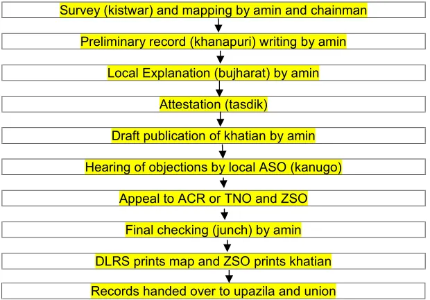
Land surveying system of Bangladesh is conducted traditionally. The term land settlement has taken up the responsibility of land survey and it is managed by the Directorate of Land Records and Surveys (DLRS). A diara settlement officer is the in charge who look after over sees surveys of riverine areas and major urban areas where frequent land ownership alteration occurs. The land surveying system involves two tasks-land measurement and the map drawing but in a very primitive process, where little modification is highly required. The land measurement is done by some people known as Amin, a person who measures the land and collect its data. Measuring tape is used to assess the length of the land, as it is placed around the boundary accordingly, to get the proper length and width of it. The updated value of the measured land was recorded and placed at the land office for its evaluation. The land surveying process can be described using 10 phases. The first phase is cadastral survey in which Amin and 2 chainmen draw the altered mouza map displaying changes in area, location and characteristics of land followed by demarcations or boundaries.
DC, thana and union land offices, which is entailed into Fig. 2.
2. Land management
The land management system Bangladesh is totally obsolete and outdated. The complete system depends entirely on the manpower efforts. The land management includes maintaining the records of the land, selling and buying of the land, Ownership transfer of the land in various ways, creating the land deeds and their maintenance, Land related disputes management, Updating the land map and information, tax and revenue collection and many other things. There are many land offices throughout the country and every land office has its land staffs for maintaining the land management activities. Each land office has a land officer and many land staffs that collectively perform the management of land.
There are two types of land owner- individual landowner and organization based land owner. All the landowners regardless of their types need to get various ser-vices from the land offices. The services include getting the land deeds, land measurement, ownership transfer activities including selling and buying, getting resolution of the land disputes etc. For getting all the services, the land owner is bound to go to land office. For
getting the land deeds the land owner has to apply to the land office for the land deed. The request is approved by the land officer and the land deed is prepared accordingly. For selling and buying of the land the land owner has to go to the land office to complete the land ownership transfer. There are a group of people who are known as deed writers. The land owner has to prepare a landownership transfer deed by the help of deed writers. The deed is approved by the land office and the ownership transfer is complete. The whole process requires a couple of days to complete [10] (Fig. 2).
B. Land Management System in Chars 1. Land ownership
There are two types of land ownership in chars. Most of them live in leased land and some of them in own land. The distribution of farmers according to land ownership is presented in Fig. 3.
The research has revealed that almost 98 percent people claim that they don’t have their own land. Only a few people (2%) of the chars have their own land. They take lease from the land owner. The villagers said that they have to pay 10,000-12,000 Tk. Per year for average of 0.33 acres (1 bigha) of land in chars.
Survey (kistwar) and mapping by amin and chainman
Preliminary record (khanapuri) writing by amin
Local Explanation (bujharat) by amin
Attestation (tasdik)
Draft publication of khatian by amin
Hearing of objections by local ASO (kanugo)
Appeal to ACR or TNO and ZSO
Final checking (junch) by amin
DLRS prints map and ZSO prints khatian
Fig. 2. Steps of land surveying in Bangladesh
Fig. 3. Distribution of farmers according to land ownership 2. Service from Surveyor (Amin)
The research investigates the satisfaction level of farmers by the service from the Surveyor (Fig. 4).
The research revealed that half (50 percent) of the respondents of the study are fully satisfied with the service of the Surveyor (Amin) while 25 percent said that they are not fully satisfied and other 25 percent are dissatisfied with the service.
3. Familiar with the land ownership related jargon
Farmers’ familiarity with the land ownership related jargon was also observed. The results have been presented in Fig. 5.
It was observed that most of the people (almost 50 percent) have no or a little idea about land related jargons. The rest half of the people have average to good idea with the land ownership related jargon.
4. Land-related security
The findings revealed that near about all (98 percent) people opined that they don’t get any threat from anyone. Only a very little (2%) proportion of the peoples are fearful about their land security (Fig. 6).
5. Conflict regarding land ownership
Survey shows that more than two-third people (71%) said that there is no land related conflict. But the data from KII it might be said that there are a few conflict in Chars regarding Land Management in Chars.
6. Women’s land ownership
The research observed that 62 percent people opined that women get land from their husband while 38 percent get land from their fathers’ side (Fig. 8).
7. Taking women's opinion for selling of land
In primitive time women opinions were not taken into account. The research showed that most of the cases (71%) women’s opinion is being ignored regarding land selling. Only 29% womens opinion is considered in decision making (Fig. 9).
8. Idea about CLP and M4C programs of RDA
The research observed that 50 percent people have good or a little idea about the various program of RDA in chars (Fig. 10).
C. Socio-economic Conditions of Peoples in the Chars
Fig. 4. Satisfaction of farmers by the service from the surveyor (Amin)
Fig. 5. Familiar with the land ownership related jargon
Fig. 6. Distribution of respondents according to facing threat about land related security 1. Age
According to Zope and Smith [11] an individual’s age is one of the most important factors pertaining to his personality makeup, since his need and the way in which he thinks and behaves are all closely related to the number of years he has lived. It is a norm in Bangladeshi traditional cultures that people respect the elder
ways they have long experience in many spheres of life.
The data revealed that most of the respondents were belong to the range of 35 to 70 years.
2. Educational qualification
The research found that most of the respondents
50%
0% 10% 20% 30% 40% 50% 60%
a) Satisfied
4
0 2 4 6 8 10
a) No idea b) A little bit
Fig. 4. Satisfaction of farmers by the service from the surveyor (Amin)
Fig. 5. Familiar with the land ownership related jargon
Fig. 6. Distribution of respondents according to facing threat about land related security 1. Age
According to Zope and Smith [11] an individual’s age is one of the most important factors pertaining to his personality makeup, since his need and the way in which he thinks and behaves are all closely related to the number of years he has lived. It is a norm in Bangladeshi traditional cultures that people respect the elder
ways they have long experience in many spheres of life.
The data revealed that most of the respondents were belong to the range of 35 to 70 years.
2. Educational qualification
The research found that most of the respondents
25%
25%
b) Average satisfaction c) No service
7
5
8
b) A little bit c) Average
Idea d) Good Idea
Series1
2%
98%
a) Yes b) No
Fig. 4. Satisfaction of farmers by the service from the surveyor (Amin)
Fig. 5. Familiar with the land ownership related jargon
Fig. 6. Distribution of respondents according to facing threat about land related security 1. Age
According to Zope and Smith [11] an individual’s age is one of the most important factors pertaining to his personality makeup, since his need and the way in which he thinks and behaves are all closely related to the number of years he has lived. It is a norm in Bangladeshi traditional cultures that people respect the elder
ways they have long experience in many spheres of life.
The data revealed that most of the respondents were belong to the range of 35 to 70 years.
2. Educational qualification
The research found that most of the respondents c) No service
Fig. 7. Conflict regarding the ownership of land of chars
Fig. 8. Women's land ownership
Fig. 9. Ignorance level of women’s opinion in land selling
education and only 1.9% had above secondary education (Fig. 12).
3. Monthly income and expenditure
The source of income of the char people is primarily agricultural work. They are also involved in fisheries, daily labour etc. The
comparison between monthly
income-expenditure of the respondents has been presented in Fig. 13.
D. Women Empowerment in Chars
In the Chars, women have contribution in the source of income. Most of the women are involved in agricultural activities alongside the male. In this way, the women exercise their 71%
38%
71%
Fig. 7. Conflict regarding the ownership of land of chars
Fig. 8. Women's land ownership
Fig. 9. Ignorance level of women’s opinion in land selling
education and only 1.9% had above secondary education (Fig. 12).
3. Monthly income and expenditure
The source of income of the char people is primarily agricultural work. They are also involved in fisheries, daily labour etc. The
comparison between monthly
income-expenditure of the respondents has been presented in Fig. 13.
D. Women Empowerment in Chars
In the Chars, women have contribution in the source of income. Most of the women are involved in agricultural activities alongside the male. In this way, the women exercise their 17%
12%
71%
a) Seldom
b) very few incidences c) No
62%
38% a) No
b) from father c) from husband
29%
71%
a) Yes b) No
Fig. 7. Conflict regarding the ownership of land of chars
Fig. 8. Women's land ownership
Fig. 9. Ignorance level of women’s opinion in land selling
education and only 1.9% had above secondary education (Fig. 12).
3. Monthly income and expenditure
The source of income of the char people is primarily agricultural work. They are also involved in fisheries, daily labour etc. The
comparison between monthly
income-expenditure of the respondents has been presented in Fig. 13.
D. Women Empowerment in Chars
power in family decision making process. They go to hospitals and markets while necessary. They are also aware about the family planning.
E. Expectations of the Char People
The char person expects the following things from concern authorities.
a) Training on seed production, processing, preservation and marketing.
b) Livestock training
c) Developing land communication d) Market in char
e) Expansion of social safety net (e.g. VGD, VGF, Food for Work)
f) Assurance of their children’s education g) Lease of GovernmentKhaslands
F. Problems of Land Management in Chars
1. The current land management system of Chars is backdated.
2. The obsolete procedure and lack of utilization of the technological resources have made the system more accessible to corruption.
3. The whole system is conducted manually without modern concepts, equipment and technology. As a result huge amount of disputes and confusions exist in the management of land.
4. There are many middle persons who create a lot of problems in performing the land related tasks. They keep liaison with the land staffs and build a strong network that jointly run the corruption based system.
1. FGD Findings of the study
Four FGD were conducted to further justify the results. The results of FGD have been presented in this section.
a) Land ownership and management
Most of the participants of FGD opined that they do not have the land ownership for both cultivable land and residential land. They avail the land in rental basis and pay Taka 6000 per year per Bigha (33 decimal). Sometimes tension among the people arises regarding land ownership but the frequency is very low. The land owners have to update their document if they have to claim over new char appears. The tax on the land had been waived since 2002 by the then Deputy Commissioner considering the poor condition of the people.
b) Problems of the chars
The FGD participants identified two main problems – i) Flood and ii) River Erosion which are the prime causes that threaten and destroy the livelihood of the people of that area.
Fig. 10. Idea about CLP and M4C programs of RDA
50% 13%
45
20 40 60 80power in family decision making process. They go to hospitals and markets while necessary. They are also aware about the family planning.
E. Expectations of the Char People
The char person expects the following things from concern authorities.
a) Training on seed production, processing, preservation and marketing.
b) Livestock training
c) Developing land communication d) Market in char
e) Expansion of social safety net (e.g. VGD, VGF, Food for Work)
f) Assurance of their children’s education g) Lease of GovernmentKhaslands
F. Problems of Land Management in Chars
1. The current land management system of Chars is backdated.
2. The obsolete procedure and lack of utilization of the technological resources have made the system more accessible to corruption.
3. The whole system is conducted manually without modern concepts, equipment and technology. As a result huge amount of disputes and confusions exist in the management of land.
4. There are many middle persons who create a lot of problems in performing the land related tasks. They keep liaison with the land staffs and build a strong network that jointly run the corruption based system.
1. FGD Findings of the study
Four FGD were conducted to further justify the results. The results of FGD have been presented in this section.
a) Land ownership and management
Most of the participants of FGD opined that they do not have the land ownership for both cultivable land and residential land. They avail the land in rental basis and pay Taka 6000 per year per Bigha (33 decimal). Sometimes tension among the people arises regarding land ownership but the frequency is very low. The land owners have to update their document if they have to claim over new char appears. The tax on the land had been waived since 2002 by the then Deputy Commissioner considering the poor condition of the people.
b) Problems of the chars
The FGD participants identified two main problems – i) Flood and ii) River Erosion which are the prime causes that threaten and destroy the livelihood of the people of that area.
Fig. 10. Idea about CLP and M4C programs of RDA
37%
50%
13% a) Have clearconcepts
b) a little bit concept c) No idea
45
70
35
50
45
power in family decision making process. They go to hospitals and markets while necessary. They are also aware about the family planning.
E. Expectations of the Char People
The char person expects the following things from concern authorities.
a) Training on seed production, processing, preservation and marketing.
b) Livestock training
c) Developing land communication d) Market in char
e) Expansion of social safety net (e.g. VGD, VGF, Food for Work)
f) Assurance of their children’s education g) Lease of GovernmentKhaslands
F. Problems of Land Management in Chars
1. The current land management system of Chars is backdated.
2. The obsolete procedure and lack of utilization of the technological resources have made the system more accessible to corruption.
3. The whole system is conducted manually without modern concepts, equipment and technology. As a result huge amount of disputes and confusions exist in the management of land.
4. There are many middle persons who create a lot of problems in performing the land related tasks. They keep liaison with the land staffs and build a strong network that jointly run the corruption based system.
1. FGD Findings of the study
Four FGD were conducted to further justify the results. The results of FGD have been presented in this section.
a) Land ownership and management
Most of the participants of FGD opined that they do not have the land ownership for both cultivable land and residential land. They avail the land in rental basis and pay Taka 6000 per year per Bigha (33 decimal). Sometimes tension among the people arises regarding land ownership but the frequency is very low. The land owners have to update their document if they have to claim over new char appears. The tax on the land had been waived since 2002 by the then Deputy Commissioner considering the poor condition of the people.
b) Problems of the chars
The FGD participants identified two main problems – i) Flood and ii) River Erosion which are the prime causes that threaten and destroy the livelihood of the people of that area.
Fig. 12. Distribution of the respondents according to educational qualification
Fig. 13. Comparison between monthly income and expenditure of the respondents
c) Knowledge about Char Livelihood Programme (CLP)
The most of the inhabitants of the char has several experiences of being affected by floods which damaged their houses and they had to rebuild it again. At present there is no NGO or Government program active for the development of the livelihood of the peoples. However, the landowner knows about Char Livelihood Program (CLP) from which they got livestock and plinth raising facilities.
d) Money lending mechanism
The inhabitants of the char, lacking resources and capital to generate new income take loans
from local money lenders in high interest. The interest is taka 500 in six months per thousand taka lend which equals to 100% interest rate in a year. Since there is very little scope of getting capital help, the farmers have no other choice but to take loan from local money lenders.
4. CONCLUSION
Char is the most vulnerable but emerging location of the country where prevails the most interesting developing potentialities. The char area may be an important source of resources from where the national GDP may be incorporated if the char area may be properly managed and the land administration of char 68.3
0
20
40
60
80
Can sign only
(0.5) Primary level(1-5)
1 2
5000
3000 4000
2800
Monthly income
Fig. 12. Distribution of the respondents according to educational qualification
Fig. 13. Comparison between monthly income and expenditure of the respondents
c) Knowledge about Char Livelihood Programme (CLP)
The most of the inhabitants of the char has several experiences of being affected by floods which damaged their houses and they had to rebuild it again. At present there is no NGO or Government program active for the development of the livelihood of the peoples. However, the landowner knows about Char Livelihood Program (CLP) from which they got livestock and plinth raising facilities.
d) Money lending mechanism
The inhabitants of the char, lacking resources and capital to generate new income take loans
from local money lenders in high interest. The interest is taka 500 in six months per thousand taka lend which equals to 100% interest rate in a year. Since there is very little scope of getting capital help, the farmers have no other choice but to take loan from local money lenders.
4. CONCLUSION
Char is the most vulnerable but emerging location of the country where prevails the most interesting developing potentialities. The char area may be an important source of resources from where the national GDP may be incorporated if the char area may be properly managed and the land administration of char
11.5 18.3
1.9
Primary level
(1-5) level ( 6-10)Secondary secondary levelAbove (>10)
Series1
3 4 5 6
5000
7600
0
5000
4700 4560
3000
4900 Monthly income Monthly expenditure
Fig. 12. Distribution of the respondents according to educational qualification
Fig. 13. Comparison between monthly income and expenditure of the respondents
c) Knowledge about Char Livelihood Programme (CLP)
The most of the inhabitants of the char has several experiences of being affected by floods which damaged their houses and they had to rebuild it again. At present there is no NGO or Government program active for the development of the livelihood of the peoples. However, the landowner knows about Char Livelihood Program (CLP) from which they got livestock and plinth raising facilities.
d) Money lending mechanism
The inhabitants of the char, lacking resources and capital to generate new income take loans
from local money lenders in high interest. The interest is taka 500 in six months per thousand taka lend which equals to 100% interest rate in a year. Since there is very little scope of getting capital help, the farmers have no other choice but to take loan from local money lenders.
4. CONCLUSION
Char is the most vulnerable but emerging location of the country where prevails the most interesting developing potentialities. The char area may be an important source of resources from where the national GDP may be incorporated if the char area may be properly managed and the land administration of char
Series1
area become secured. Most of the peoples in chars live in leased land areas who take lease land from land owner. Half of the respondents of the chars are fully satisfied with the service of the Surveyor. Households in the chars are more food insecure, the quality of the diet is worse and more children and women are malnourished than elsewhere in the country. This is partly due to the high vulnerability to flooding and riverbank erosion, which attracts only those with no better alternative, but also because there are few opportunities for employment, inadequate infrastructure, a lack of government and NGOs services, and because opportunities for homestead food production that are adapted to the special ecological conditions have yet to be developed in many areas.
5. RECOMMENDATIONS
Interventions are needed to improve living conditions in the chars and to help the char dwellers make best use of their available resources.
1. Proper distribution of land and khash land
among the farmers. Improving
transportation networking and connection with the main land
2. Plinth raising that will act as a shelter during flood
3. Intervention of government for providing livelihood support e.g. provide loan, give cows/goats to old aged females and widows,
4. Provide good quality seeds from RDA technical support to preserve new seeds. 5. Homestead food production and home
gardening should be encouraged through proper training
6. Nutritional security of foods must be ensured.
6. POLICY RECOMMENDATIONS
Some policies may be taken to solve the problems and development of the land management system:
1. Proper land survey and land mapping should be done.
2. ICT for data record related to land should be used. Computerized information
3. It is very emergency to take policy to reduce the discrimination of ownership of land in the chars.
4. Increasing the monitoring of land surveyors and union land office.
5. Recruitment of manpower who will be solely responsible for the Land Management of chars.
COMPETING INTERESTS
Authors have declared that no competing interests exist.
REFERENCES
1. BBS. Statistical Year Book of Bangladesh.
Bangladesh Bureau of Statistics, Ministry of Planning, Government of the People’s Republic of Bangladesh; 2014.
2. BBS. Statistical Year Book of Bangladesh.
Bangladesh Bureau of Statistics, Ministry of Planning, Government of the People’s Republic of Bangladesh; 2011.
3. Saidhur R, Davis J. A Survey of Rural Livelihood and Enterprise Development Opportunities in the Chars of Bangladesh.
DFID Poverty Oriented Research
Programme, Dhaka, Bangladesh; 2005. 4. Kasimbazi E. Land Tenure and Rights for
Improved Land Management and
Sustainable Development. Global Land Outlook Working Paper. United Nations Convention to Combat Desertification; 2017.
5. Rahman M. Char Development and
Settlement Project Phase IV. Protection from climate change on coastal chars. Government of the Peoples Republic of Bangladesh, Dhaka; 2017.
6. Rahman MR. Impact of Riverbank
Erosion Hazard in the Jamuna Floodplain Areas of Bangladesh. Journal of Science Foundation. 2010;8(1-2):55-65.
7. Aziz MA. Land Record System in
Bangladesh: An Analysis of Problems and Possible Solutions; 2003.
Available:http://www.google.com.bd/searc h?q, Land Information System in
Bangladesh
8. Ahmed KU. Land survey methods and
technical rules, Dhaka: Payara
9. Siddiqui K. Land management in South Asia- a comparative study. Dhaka: The University Press Limited; 1997.
10. Talukder SK, Sakib MII, Rahman MM. Digital land management system: A new initiative in Bangladeh. International
Conference on Electrical Engineering and Information & Communication Technology (ICEEICT), Dhaka; 2015.
11. Zope PE, Smith JE. Principles of Inductive Rural Sociology. Philadelphia: F.A. Devis Co.; 1970.
© 2018 Zakaria et al.; This is an Open Access article distributed under the terms of the Creative Commons Attribution License (http://creativecommons.org/licenses/by/4.0), which permits unrestricted use, distribution, and reproduction in any medium, provided the original work is properly cited.
Peer-review history: