ANDROID BASED HEALTHCARE SYSTEM USING
AUGMENTED REALITY
Raksha Shelar
1, Shweta Patil
2, Vaishnavi Chidgopkar
31, 2, 3 Department of Computer Engineering, Padmashree.
Dr. D. Y. Patil Institute of Engineering,Management and Research, Pune,(India)
ABSTRACT
In Digital Age people use their mobile device for many purpose like searching any location or information using
GPS and internet, playing games, etc. People in unknown area face difficulties to find hospital. The aim of this
paper is to build Healthcare system using Augmented Reality concept and provide flexibility to people to
access medical information, like doctors’ address and contact numbers, contact details of Ambulance service
and also can find out nearer medical store and hospital at anytime from anywhere. AR (Augmented Reality) is
innovative technology which provides a real time world environment and let you present an enhanced view of
real world [4]. Location tracking technology could make a big influence on human health and well being in
future. This system provides all the information on the android device. Using JSON parsing we will keep
updated record about doctor‘s contact details and their location.
Keywords
—Android operating system, Augmented Reality, Google map, GPS, JSON.
I. INTRODUCTION
Now days it is necessary to have a proper healthcare system. This application is based on Android device. It
helps people to get the hospital location, contact details of ambulance services provided by social organization
and the location of medical stores. People can easily access all the healthcare utility despite of their current
location. We are implementing Augmented Reality concept on android phone [5]. This Healthcare system uses
camera of phone to access location. Augmented reality (AR) is one type of virtual reality. This technology
mainly works with the sensors [4]. It can be used on any type of connected devices and screen. AR is used in
many applications like medical, manufacturing and repair, engineering design, entertainment, manufacturing,
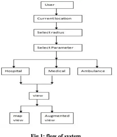
robotics, military training etc. In Our application first user selects the radius, after selecting radius, user will
select the category of doctors, process the data, plot the location of hospital, and provide proper doctor‘s contact
details using JSON parsing. This technology uses various sensors embedded in the mobile device.
II.PROPOSED
SYSTEM
In this application user can access hospital despite of his current location, and it can also locate the ambulance
service provider and nearby medical store. The important feature of this application is augmented reality. AR
makes use of various sensors embedded in the android phone [4], like Location sensors i.e.:- GPS, the location
between any two locations but it simply deliver the top view of the map so it make complex situation for user
between the mobile standard north (that is fixed), and the frequent change in position of the user in real time.
Fig 1: flow of system
To overcome this problem we are developing an application that allows user to select location and then gives
options to select parameters like category of doctors, medical store or ambulance .(The flow of proposed system
is given in above diagram ) If user selects category of doctor then application provides list of doctor‘s type then
user can select the type of doctor from list like Dermatologist, cardiologist, optician, dentist, pediatrician,
gynecologist, neurologist, orthopedic, etc. and it automatically identify your current location and plots it on a
Google map using an marker and provide an short depiction on it about the hospital. If user selects Ambulance
as parameter then application provides list of the contact numbers of ambulance services provided by social
organization in that particular area. The system supports two navigation modes and the user can switch between
them by pressing a button on the mobile device
A. Map view
In map view, the system is continuously choosing the higher accuracy location sensor by comparing between its
GPS and signals from the network provider, and using these to determine the user’s location. After the device initialises the user’s location, it displays that location on the map. After determining the user’s desired
destination, the system connects to the Google server using the Google Maps Application Programming
In this application all data is link through Google (as we are using JSON parsing). There is no need to manage
separate data base.
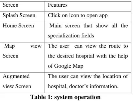
Screen Features
Splash Screen Click on icon to open app
Home Screen Main screen that show all the
specialization fields
Map view
Screen
The user can view the route to
the desired hospital with the help
of Google Map
Augmented
view Screen
The user can view the location of
hospital, doctor’s information.
Table 1: system operation
The location need to be real time because all users have access to the map, they need to know where their exact
location is. There are two types of location coordinate to find exact location of user.
1. Network Location Provider.
2. GPS Location Provider.
Network and GPS Location Provider are two different ways to get Android device location (Lat and Long).Both
have got their own advantages .for example ,In in-door situation GPS may not provide location quickly and
Network Location Provider is quick. Network Location Provider uses our mobile connectivity provider and
gives nearest tower location where GPS give exact location where user is stand.
GPS Location Provider
GPS is a technology which determining a location using signals from a network of satellites. This satellite
transmits data continuously. All that's needed is a GPS receiver and a clear view of the sky to receive signals
from at least three or four GPS satellites. The signal contains data that a receiver uses to compute the locations
and make other adjustments which are needed for accurate positioning. The basic GPS service provides users
with approximately 7.8 meter accuracy, 95% of the time, anywhere on or near the surface of the earth. Common
uses of GPS include vehicle navigation, tracking the location of business assets, mapping for outdoor recreation.
III.SYSTEM
ARCHITECTURE
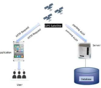
Following”fig” represents architecture of proposed system. It consists of GPS, Google Server, LBS (Location
Fig 2: system architecture
C. Working of system
Retrieving GPS data and sending an automatically-generated message
System receives GPS signals from satellites and stores it in user’s vicinity, and then GPS unit calculates data
which include three-dimensional velocity, position and time information.
Processing of GPS data and storing of GPS data into database
GPRS communication Network is involved to act as an intermediary that connects the both ends the user and the
server. GSM terminals are used at both ends. GSM terminal at sender’s side process the location information
acquired from the GPS unit and sending it to web server via Short Message Service and the other GSM terminal
at the server side is responsible for transferring the data to the local device. Finally, the program embedded in
the device will plot users’ position onto Google Maps.
Propose system allow user to use Augmented Reality Concept. So a user can create query by scanning the
nearby street with a camera in real space and searches accessible content along the street using information
space. Then, system plots the results on both sides of the street so it solves the issue of Overlapping.
D. LBS (Location Base Sensor)
Location-based services use geo-data of mobile device to provide information. It is refer as set of applications
that accomplish the knowledge of the geographical location of a mobile device in order to provide services
based on that information [2]. LBS is use to track user location and also provides traffic information, it also
provide security for device.
IV.TECHNOLOGY
AND
CONCEPT
Location based AR
Projection AR
Recognition AR
Outline AR
We are use Location based AR. It consists of Marker based and Marker Less AR. Marker based AR uses camera
while Marker less AR uses GPS and Digital compass sensor.
V.CONCLUSION
In this paper we have presented an android based healthcare application with augmented reality. so in
emergency situation or at unknown place our system provides facility to find hospital location, doctor’s address
and contact details. augmented reality concept simplifies navigation problem of google map.
REFERENCE
[1] Global Illumination for Augmented Reality on Mobile Phones: Yong Beom Lee§ Samsung Advanced
Institute of Technology Samsung
[2] Amit Kushwaha, Vineet Kushwaha ‗Location Based Services using Android Mobile Operating
System‗International Journal of Advances in Engineering & Technology, © IJAET ISSN: 2231-1963.
[3] M. Alcaniz, D. C. Perez- Lopez, and M. Ortega, ―Design and Validation of an Augmented Book for
Spatial Abilities Development in Engineering Students‖, Computers & Graphics, 2010, 34(1), pp. 77-91.
[4] J. Joachim, R. Newcombe, and A. Davison. Real-time surface lightfield capture for augmentation of planar
specula surfaces. In Proceedings of the 2012 IEEE International Symposium on Mixed and Augmented
Reality (ISMAR), pages 91–97, Atlanda, USA,Oct. 2012.
[5] Francois Andry, Lin Wan and Daren Nicholson, ―A Mobile Application Accessing Patients‘Healthcare
Records through a Rest API, ‖IEEE 2012.
[6] Onlive. Onlive Last accessed: 28 March 2013. http://www. onlive.com/.
[7] Hand-held Mobile Augmented Reality for Collaborative Problem Solving: A Case Study with Sorting: