www.clim-past.net/8/1973/2012/ doi:10.5194/cp-8-1973-2012
© Author(s) 2012. CC Attribution 3.0 License.
Climate
of the Past
Pollen-based reconstruction of Holocene vegetation and climate in
southern Italy: the case of Lago Trifoglietti
S. Joannin1,2,3, E. Brugiapaglia4, J.-L. de Beaulieu5, L. Bernardo6, M. Magny2, O. Peyron2, S. Goring7, and B. Vanni`ere2
1CNRS – USR3124 MSHE Ledoux, Besanc¸on, France
2CNRS – UMR6249 Laboratoire Chrono-Environnement, Universit´e de Franche-Comt´e, Besanc¸on, France 3CNRS – UMR5276 LGL TPE, Universit´e Lyon 1, Villeurbanne, France
4Dipartimento di Scienze Animali, Vegetali e dell’Ambiente, Universit`a degli Studi del Molise, Campobasso, Italy 5CNRS – UMR7263 IMBE, Universit´e d’Aix-Marseille, Aix en Provence, France
6Orto botanico, Universit`a della Calabria, Cosenza, Italy
7Department of Geography, University of Wisconsin-Madison, Wisconsin, USA
Correspondence to: S. Joannin (sebastien.joannin@univ-lyon1.fr), E. Brugiapaglia (e.brugiapaglia@unimol.it),
J.-L. de Beaulieu (jacques-louis.debeaulieu@imbe.fr), L. Bernardo (l.bernardo@unical.it),
M. Magny (michel.magny@univ-fcomte.fr), O. Peyron (odile.peyron@univ-fcomte.fr), S. Goring (goring@wisc.edu), and B. Vanni`ere (boris.vanniere@univ-fcomte.fr)
Received: 1 June 2012 – Published in Clim. Past Discuss.: 15 June 2012
Revised: 10 October 2012 – Accepted: 12 November 2012 – Published: 7 December 2012
Abstract. A high-resolution pollen record from Lago
Tri-foglietti in Calabria (southern Italy) provides new insights into the paleoenvironmental and palaeoclimatic changes which characterise the Holocene period in the southern Italy. The chronology is based on 11 AMS radiocarbon dates from terrestrial organic material. The Holocene history of the veg-etation cover shows the persistence of an important and rela-tively stable Fagus forest present over that entire period, of-fering a rare example of a beech woodstand able to withstand climate changes for more than 11 000 yr. Probably in rela-tion with early Holocene dry climate condirela-tions which af-fected southern Italy, the Trifoglietti pollen record supports a southward delay in thermophyllous forest expansion dated to ca. 13 500 cal BP at Monticchio, ca. 11 000 cal BP at Tri-foglietti, and finally ca. 9800 cal BP in Sicily. Regarding the human impact history, the Trifoglietti pollen record shows only poor imprints of agricultural activities and anthopogenic indicators, apart from those indicating pastoralism activities beneath forest cover. The selective exploitation of Abies ap-pears to have been the strongest human impact on the Tri-foglietti surroundings. On the basis of (1) a specific ratio between hygrophilous and terrestrial taxa, and (2) the Mod-ern Analogue Technique, the pollen data collected at Lago Trifoglietti led to the establishment of two palaeoclimatic
1 Introduction
The major climate changes which developed from the end of the last Glacial to the Holocene are now relatively well estab-lished in Europe (e.g., Bj¨orck et al., 1996, 1998). On the con-tinent, climate history is recorded through different indica-tors including vegetation changes driven by variations in the orbitally-induced insolation change and associated variations in climate parameters such as precipitation and growing-season temperature. Whereas the Holocene climate may ap-pear as a relatively stable temperate period, it was, netherthe-less, punctuated by numerous rapid cold events such as the Preboreal and Boreal oscillations (Bj¨orck et al., 1997, 2001; Fleitmann et al., 2007; Yu et al., 2010), the 8.2 kyr event (Wiersma and Jongma, 2010) and the Neoglacial climate cooling at ca. 6000–5000 cal BP (Magny et al., 2006b; Miller et al., 2010).
These events are also recorded in the Mediterranean area, where they suggest a strong connection between higher and lower latitude regions (e.g., Asioli et al., 1999; Favaretto et al., 2008; Magny et al., 2006a, 2007b, 2009; Combourieu Nebout et al., 2009; Pross et al., 2009; Fletcher et al., 2010). However, on closer examination, paleoenvironmental records point to regional diversity in the effects of rapid climate change throughout the Mediterranean region (e.g., Roberts et al., 2011a; Magny et al., 2011a). This underscores the complexity of the Mediterranean climate, which may re-flect contrasting influences from both higher latitudes (e.g., deglacial events, the North Atlantic Oscillation) and lower latitudes (e.g., the tropical monsoon) which, for instance, may have affected westerly activity and associated precipita-tion changes over the Italian Peninsula (Magny et al., 2002, 2007a; Zanchetta et al., 2007).
Moreover, particularly in the Mediterranean regions where human impact has been widespread at least since the Ne-olithic (Guilaine, 2003), it is sometimes difficult to dis-entangle the climatic and anthropogenic forcing factors in palaeoenvironmental records (De Beaulieu et al., 2005; Roberts et al., 2011b). This complexity is reinforced by a possible climate determinism for human societies and by human-induced environmental changes (on a wider-than-local scale) which are expected to enhance regional climate impact (Jalut et al., 2009; Tinner et al., 2009). While the pollen proxy does not escape this ambiguity in paleoenvi-ronmental reconstructions and interpretations (Sadori et al., 2010), it may be of great interest in providing direct and/or indirect evidence of anthropogenic activities (Mercuri et al., 2010).
Southern Italy is a place where climate and human influ-ences are superimposed, with (1) orbitally induced long-term climate changes and possible short-term time-transgressive climate oscillations developing according to latitude (Di Rita and Magri, 2009), and (2) major cultural changes such as the Neolithic expansion in southeastern Italy between 9000 and 8000 cal BP and in south-western Italy between 8000 and
19
20°E 18°E
16°E 14°E
18°E 16°E
14°E 12°E
12°E 42°N
40°N
40°N
38°N
38°N
36°N Elevation (m)
0 500 1 000 1 500 2 000 2 500 3 000
Tyrrhenian Sea
Adriatic Sea
Lago Trifoglietti
ATLANTIC OCEAN
MEDITERRANEAN SEA
LP-GB LPer
LGM
GL LA-LN
CN
LAP C106
Napoli
Palermo
BG LB
BS7938
AD91-17 MD90-917
0 2550 100 150 200 Kilometers
GC
BS7937 BS7922
Fig. 1. Location of study site and other sites considered in the text: Lago Albano and Nemi (Ariztegui et al., 2000 and references therein), Lago Battaglia (Caroli and Caldara, 2007), Lago Alim-ini Piccolo (Di Rita and Magri, 2009), Lago Grande di Monticchio (Allen et al., 2002), C106 (Di Donato et al., 2008), Grotta di La-tronico (Colonese et al., 2010), Canolo Nuovo (Schneider, 1985), Lago di Pergusa (Sadori and Narcisi, 2001), Biviere di Gela (Noti et al., 2009), Grotta di Carburangeli (Frisia et al., 2006), Gorgo Basso (Tinner et al., 2009), Lago Preola (Magny et al., 2011b; Cal`o et al., 2012), AD91-17 (Sangiorgi et al., 2003), BS7938 (Sbaffi et al., 2004), MD90-917 (Siani et al., 2012).
7500 cal BP (Guilaine, 2003; Berger and Guilaine, 2009). Thus, southern Italy is of great importance when discussing natural vs. anthropogenic forcing of vegetation changes. However, on the other hand, pollen-based Holocene vegeta-tion records from southern Italy are still sparse and most of them are from low altitudes (Fig. 1). Only Lago Grande di Monticchio (656 m a.s.l.; Allen et al., 2002) and Lago di Per-gusa in Sicily (667 m a.s.l.; Sadori et al., 2011) are located in the collinean belt, which are separated by 450 km, provide a forest development asynchronism of ca. 4000 yr.
Palynological study of the Trifoglietti site in the merid-ional part of the Apennines help to fill the gaps between pre-vious studies. It may give evidence of elements characteris-ing long-term vegetation dynamics in a place close to glacial refugia, as well as of the possible influences of Holocene rapid climate changes and the Neolithic expansion on vege-tation. Finally, it may provide additional data for a better un-derstanding of regional climate variability and possible con-trasting changes in seasonality between central and southern Italy (Magny et al., 2011a).
Spring
Communities of Alnus cordata
Communities of Fagus sylvatica
Forest of Fagus sylvatica
including plantations of conifers
Pastures and scrublands
Wetlands and water bodies
Communities of Castanea sativa
Cores
Pollen surface samples (moss)
S2
S1
S3 1
2
3
5
4
b
a
Lago Trifoglietti
1 1048
m a.s.l. Lago dei due Uomini
Lago Trifoglietti
Fig. 2. (a) Actual vegetation map; (b) coring sites, surface samples and relev´es localisation.
intermediate location between central Italy and Sicily, and (2) to reconstruct possible palaeohydrological (climatic) variations reflected by changes in vegetation.
2 General description of the site
2.1 Location
Lago Trifoglietti (39◦330N, 16◦010E; 1048 m a.s.l.) is
lo-cated in southern Italy (Fig. 1), near the town of Fagnano Castello in Cosenza province. Overlooked by Monte Caloria (1183 m), Lago Trifoglietti is part of a natural high-altitude lucustrine system inhabited by endemic amphibians (Sper-one et al., 2007). Thus, protected within a Natura 2000 z(Sper-one (SIC IT9310060 – Laghi di Fagnano), the lakes are located in the Catena Costiera Mountains which stretch parallel along the Tyrrhenian coast for 70 km with altitudes ranging from 1060 and 1541 m (Sperone et al., 2007). This part of the Catena Costiera belongs to the Liguride complex outcrop and is formed of metamorphic terrigenous deposits of a solid-textured green rock which is, consequently, only weakly eroded (Ogniben, 1973; Ogniben and Vezzani, 1976). The soils, classified as Dystric Cambisols by the World Refer-ence Base (WRB) and as Dystrudept in Soil Taxonomy (AR-SSA, 2003), are composed of high organic matter input to the mineral fraction units resulting in thin acid soils with a dark brown and lumpy texture.
The origin of the Catena Costiera lakes is not well estab-lished. Guerricchio (1985) suggests that they were created by large landslides and were filled by spring overflow. Initially, the lakes had an elongated shape, following the direction of depression created behind the landslide body, but subsequent
0 20 40
Fagnano Castello (516 m a.s.l.) 15 °C 1850 mm
0 100 200 300 mm °C
J F M A M J J A S O N D
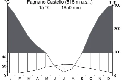
Fig. 3. Ombrothermic diagram of the meteorological station of Fag-nano Castello, about 3 km away from Lago Trifoglietti. This station is on the eastern side of the mountain range, and the record ran for 42 yr (1921–1968; Ciancio, 1971).
infilling with material from mountain runoff progressively gave them a rounded shape.
At Trifoglietti nowadays, a spring flows into the lake from the north; an outflow runs southward (Fig. 2a–b). To combat summer drought, the Municipality of Fagnano Castello built a small earthen dam in 2000. With a surface area of 0.973 ha and a catchment area covering 0.370 km2, the lake reaches a depth of up to 1.50 m.
2.2 Climate and phytogeography
2.2.1 Climate
Due to its geographical position and to its relatively high ele-vation a.s.l., the climate of the Trifoglietti region is greatly in-fluenced by warm and humid air masses from the Tyrrhenian Sea. Despite the strictly Mediterranean latitude of the study area, annual rainfall can reach more than 1800 mm yr−1 (Fig. 3), though a relatively short dry period develops in sum-mer (Ciancio, 1971). According to the bioclimatic classifica-tion proposed by Rivas-Martinez (1993) and based on both corrected summer ombrothermic index (Iovc) and the cor-rected thermic index (Itc), the Trifoglietti area falls within the “lower mesotemperate bioclimate belt” of a temperate region and the ombrotype is “upper hyperhumid”. Mean an-nual temperature is 15◦C, with 24◦C for August and 7.5◦C for January.
2.2.2 Phytogeography
The Catena Costiera vegetation is dominated by Fagus
syl-vatica, Quercus cerris and Castanea sativa. The lake is
sur-rounded by a beech forest attributed to Anemono
apenninae-Fagetum with some Pinus nigra subsp. laricio. Scrub
vege-tation, with Erica arborea, Cistus salvifolius, Helichrysum
italicum, Sarothamnus scoparius and Alnus cordata trees,
A B C D E
F F
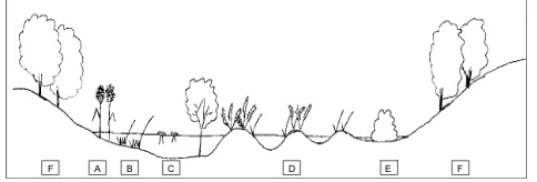
Fig. 4. Transect of actual vegetation around Lago Trifoglietti. A: Sparganium erectum; B: Carex vesicaria; C: Potamogeton natans, P. nodosus and Alnus cordata trees; D: Carex paniculata, Osmunda regalis; E: Carex pendula, Mentha aquatica, Rubus ulmi-folius; F: Fagus.
A schematic transect of present-day vegetation is pre-sented in Fig. 4. The lake vegetation comprises of a mosaic of different plant communities, partly linked with dynamic suc-cessions due to variations in water level and soil composition. Most of the lake surface is occupied by a Carex paniculata swamp (D). This tall sedge grows in spaced tussocks pro-truding from the water surface, the living plant progressively builds up around a small peaty hill, often covered by a carpet of Sphagnum palustre and Aulacomnium palustre. Between tussocks the water attains a depth of 60 cm, and since vegetal fibres accumulate in the ground, which tends to dry up, the sedge is, therefore, progressively invaded by other helophyte and mesophyte species. In shallow areas (E), Carex
panic-ulata develops with Osmunda regalis, Angelica sylvestris, Carex pendula and nemoral herbs such as Lysimachia nemo-rum, Arisarum proboscideum and Oxalis acetosella. The
lit-toral mires are invaded by Rubus hirtus and R. ulmifolius (E) and two isolated bushy communities of Salix caprea very near the surrounding beech forest (F).
From the centre of the lake to the southern edge, the depth increases and the open surface is discontinuously colonised by communities of Potamogeton natans (C). The lake’s west-ern shore is supplied by the rills, where a belt of vegetation is found characterised by Sparganium erectum (A). Alisma
plantago-aquatica and Ranunculus fontanus are rare in this
community, the sedge bed being dominated by Carex
vesi-caria (B) within the belt and outside of the peaty soil.
A limited stand of Alnus cordata (C) develops near the lake centre (deeper water) and appears to be in regression. We hypothesise that this tree species grew in the sunniest area around the lake when the marshes were in a dry phase. The anthropogenic rise in water depth, however, is not compati-ble with the alder’s ecological needs. The importance of Lago Trifoglietti depends on the presence of the endemic amphib-ians and on endangered aquatic and hygrophilous habitats in the Mediterranean area (Sperone et al., 2007). The dam, thus, provides the appropriate water depth ensuring continu-ity of all interesting aquatic habitats and species. The increas-ing depth, however, has certainly submerged and damaged species such as Sphagnum palustre and Osmunda regalis.
3 Methods
3.1 Core sampling and sedimentology
Coring was undertaken using a 1 m long Russian peat corer with a 6.3 cm diameter. Three cores were taken (S1, S2 and S3; Fig. 2b) along a transect from centre of the lake toward the northeastern shore to find a sediment sequence capable of documenting the entire Holocene in high resolution. Thus, the core S2 sequence was chosen for laboratory investiga-tion and was obtained from twin cores taken from the lake’s north-east edge. Segments were extracted on site, wrapped in plastic, transported to the University of Franche-Comt´e and stored at 4◦C.
The cores were split longitudinally into two halves, pho-tographed and logged with a GEOTEK Multi Sensor Core Logger in order to obtain geophysical measurements (scan-ning of lithology, measurements of magnetic susceptibility, MS) at 1 cm intervals. The master core (MC) was established based on lithological changes (with observation of key refer-ence horizons) in combination with MS profiles. This study, thus, refers to the MC constructed from the twin cores (S2A and S2B).
The MS, mainly dependent on magnetite concentration in sediments, was measured in electromagnetic units to deter-mine the inorganic allochthonous sediment content (Gedye et al., 2000). As the development of pedogenesis under forest cover may have favoured a mineral magnetic increase in soils (de Jong et al., 1998), low MS recorded in sediments is to be expected during phases of stabilised vegetated slopes (Whit-lock et al., 2011), while increased magnetic concentrations may be related to changes in sediment sources and to erosive processes of soils (Dearing et al., 1996; de Jong et al., 1998; Vanni`ere et al., 2003; Cruise et al., 2009). Nevertheless, when ferrimagnetic mineral concentration is low (magnetite and maghaemite), the value of MS may be largely influenced by diamagnetic minerals (quartz, carbonates) (Thompson and Oldfield, 1986).
3.2 Radiocarbon dating
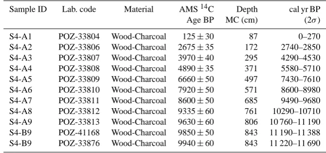
Table 1. AMS-radiocarbon dates with 2σ range of calibration from Lago Trifoglietti’s S2A and S2B cores.
Sample ID Lab. code Material AMS14C Depth cal yr BP
Age BP MC (cm) (2σ)
S4-A1 POZ-33804 Wood-Charcoal 125±30 87 0–270
S4-A2 POZ-33806 Wood-Charcoal 2675±35 172 2740–2850
S4-A3 POZ-33807 Wood-Charcoal 3970±40 295 4290–4530
S4-A4 POZ-33808 Wood-Charcoal 4890±35 371 5580–5710
S4-A5 POZ-33809 Wood-Charcoal 6660±50 497 7430–7610
S4-A6 POZ-33810 Wood-Charcoal 7920±50 571 8600–8980
S4-A7 POZ-33811 Wood-Charcoal 8600±50 685 9490–9680
S4-A8 POZ-33812 Wood-Charcoal 9335±60 761 10290–10710
S4-A9 POZ-33813 Wood-Charcoal 9630±60 806 10 760–11 190
S4-B9 POZ-41168 Wood-Charcoal 9850±50 843 11 190–11 388
S4-B9 POZ-33876 Wood-Charcoal 9940±60 843 11 220–11 690
3.3 Pollen analysis
3.3.1 Surface samples
Studying the relationship between pollen rain and actual veg-etation is essential for the interprveg-etation of fossil pollen spec-tra. The pollen rain depends primarily on the internal param-eters of the plant (production potential and dispersion) and external factors (topography and climate). Barthelemy and Jolly (1989) consider that the most important factor is the to-pography: the wind that rises along the slope, carrying the pollen that falls to the ground where the slope is interrupted by a shelf. The deposit is then behind the edge of the shelf into the basin (Brugiapaglia et al., 1998). At Trifoglietti, the filter effect operated by the dense forest vegetation that sur-rounds the lake is also taken into account. In order to interpret the fossil diagram, five moss samples were collected (Fig. 2b) and treated both chemically (NaOH, HCl, HF, acetolysis) and physically (sieving 300 and 180 µm). To emphasise the cor-relation between pollen rain and vegetation, we provide the corresponding phytosociological relev´es of actual vegetation (Pignatti, 1953) (Table 2) along with the five surface sam-ples, using the TILIA 1.12 programme. A pollen diagram of selected taxa from surface samples is provided in Fig. 6.
3.3.2 Pollen samples
Sediment samples of 1 cm3 of sediments were treated both chemically (HCl, KOH, HF, acetolysis) and physically (siev-ing) following standard procedures (Moore et al., 1991).
Ly-copodium tablets were added for estimating pollen
concen-trations (grains cm−3). Samples were taken at four centime-tres resolution on the 8.5 m of the core. A total of 170 pollen samples were analysed under a light microscope at a stan-dard magnification of×400. 178 pollen types were identi-fied using photo atlases (Reille, 1992–1998; Beug, 2004) and the reference collection at the University of Franche-Comt´e. A sum of at least 300 terrestrial pollen grains was counted,
excluding dominant terrestrial taxa along with water and wet-land plants, as well as pteridophyte spores. Percentages were calculated based on the total pollen sum.
Using the TILIA 1.12 programme, a pollen diagram of selected taxa is provided in Fig. 7. Local pollen assem-blage zones (LPAZ) were defined according to the CONISS function of the TILIA 1.12 programme. Two drawn and twelve dashed lines define limits between statistically first-and second-order splits. Table 3 sums the main, common and rare pollen types in each LPAZ. In order to describe vegetation changes, taxa have been grouped according to their present-day ecology, with the help of field observa-tion and according to their affinities with human-induced activities. Figure 7 represents taxa as follows (from left to right): trees, total Arboreal Pollen (APt), plants from open-land vegetation, anthropogenic indicators (Apiaceae, Apium,
Meum, Peucedanum tp., Bupleurum tp., Plantago, Plantago major/P. media, Cannabaceae, Urticaceae, Papaver, Linum)
and Cerealia tp. (Cereal tp. 40–60 µm, Triticum, Secale tp.). All pollen taxa percentages have been calculated according to the total counted terrestrial pollen grains. Figure 8 presents a simplified pollen diagram with major arboreal and non-arboreal taxa and the sum of anthropogenic indicators.
Hygrophilous plants have been placed separately in the il-lustrations (Table 3; Figs. 7 and 8). They are composed of aquatics (pollen: Cyperaceae, Carex tp., Scirpus tp.,
Cype-rus tp. Alisma, Ceratophyllum sp., Cladium mariscus, Lysi-machia, Mentha, Myriophyllum, Nymphaeaceae,
Ranuncu-laceae tp. Batrachium, Sparganium, Typha latifolia, Typha
minima, Lythrum), of spore producers (Osmunda), of pollen
producer (Ast. Asteroideae Eupatorium) and of algae
(Botry-ococcus). Spores and algae have been added to the total
has been calculated by excluding main hygrophilous taxa (Aquatics and Eupatorium) from the NAP.
3.3.3 Pollen-based climate reconstruction
A multi-method approach of the Trifoglietti pollen sequence is applied in order to provide robust quantitative estimates of the Holocene climate and to better assess reconstruction error. We have chosen two “standard” methods based on different ecological concepts: the Modern Analogues Tech-nique (MAT, Guiot, 1990), and the Weighted Average Partial Least Squares regression (WAPLS, ter Braak and Juggins, 1993). These methods are usually applied to reconstruct cli-mate changes in Mediterranean area during the Lateglacial or the Holocene (e.g., Davis and Brewer, 2009; Dormoy et al., 2009; Di Donato et al., 2008; Joannin et al., 2011, 2012; Peyron et al., 2011; Combourieu Nebout et al., 2012). The WAPLS NMDS/GAM is a true transfer function based on a calibration between environmental variables and modern pollen assemblages whereas the MAT does not require real calibration. This method is based on a comparison of past as-semblages to modern pollen asas-semblages and used a modern pollen dataset that contains more than 3500 modern spectra (Dormoy et al., 2009) and in which surface sample spectra from Lago Trifoglietti surroundings, from Mount Altesina (close to Lake Pergusa, Sicily) and Lake Preola (Sicily) have been included. Annual precipitations (MAT Pann, WAPLS Pann) have been reconstructed and represented in Fig. 9f. Winter and summer precipitations are also reconstructed and discussed in the paper of Peyron et al. (2012) which propose a climatic reconstruction based on a multi-method approach (MAT, WA, WAPLS, NMDS/GAM) on four Italian pollen records (Lakes Ledro, Accesa, Trifoglietti, Pergusa). More details on the methods and their application to Trifoglietti’s pollen record are given in this paper. Note that Alnus is ex-cluded in the climate reconstructions performed with both the MAT and the WAPLS and that the values of precipitation calculated for the surface samples taken close to the Trifogli-etti site have been corrected according to the ombrothermic diagram of the closest meteorological station (1850 mm).
4 Results and interpretation
4.1 Sediment and age model
4.1.1 Lithological and magnetic susceptibility changes
Gyttja and peaty sediments are the main components of core S2 at Trifoglietti (Fig. 7). The stratigraphy was as follows:
– from 850 to 843 cm: gyttja layer,
– from 843 to 805 cm: silt layer,
– from 805 to 700 cm: mixed gyttja and silt layer,
0 1000 2000 300 0
4000 5000 6000 7000 8000 9000 100001100012000
100
200
300
400
500
600
700
800
900
Dates (1 and 2 sigma ranges)
Holocene Lateglacial
Master
Core (cm)
Age (years cal. BP)
125 ± 30
2675 ± 35
3970 ± 40 Age (BP)
4890 ± 35
6660 ± 50
7920 ± 50
9335 ± 60 8600 ± 50
9630 ± 60 9940 ± 60 9850 ± 50
0
Core scan
Fig. 5. Lithology and age-depth model of mastercore based on ra-diocarbon calibrated ages (AMS, see Table 1).
– from 700 to 530 cm: gyttja layer interrupted by a silt
layer from 595 to 548 cm,
– from 530 to 482 cm: dark peaty deposits,
– from 482 to 380 cm: gyttja/peat layer,
– from 380 cm to the top: deposits are characterised by
an alternation of peat and dark peat sediments that in-clude thin gyttja layers (292–289, 213–200 and 100– 97 cm) and gyttja/silt layers (162–152, 122–117 and 107–100 cm).
In general, MS values measured in gyttja and peat sedi-ments are low (Figs. 7 and 8). However, three major peaks are observed with strong values in the silt deposit at 844– 804 cm, in a woody-remains layer at 173–169 cm, and in a silt layer at 122–117 cm. In this last level, strong MS values are not explained as no volcanic minerals have been found.
4.1.2 Age-depth model
the Holocene up to around 3000 cal BP, giving an aver-age temporal resolution of about 60 yr/sample. The rate de-creases upwards. The average temporal resolution is esti-mated at ca. 70 yr/sample for the entire Holocene and at-tains a maximum of 37 yr/sample for the period 10 000– 9000 cal BP.
4.2 Pollen analysis
4.2.1 Surface samples
The five surface samples represent the different vegetation types that grow around the lake and contribute to the inter-pretation of the fossil pollen spectra. The pollen sum is about 500 grains (AP + NAP) per surface sample.
Lago Trifoglietti pollen rain broadly mimics the corre-sponding types of vegetation: in fact the filter effect, there-fore, determines that the regional pollen rain is poorly recorded, while a good assessment of the local vegetation is well demonstrated by the results obtained in the diagram (Fig. 6). On the whole, the Pinus abundance recorded in open land (3 %) is in better accordance with reality than in
Fa-gus wood (1 %). Pollen grains of Quercus robur tp., Olea
and Castanea are produced by plants absent (almost absent in the case of Castanea) from around the lake. Pollen catch-ment is likely to include lower-altitude vegetation signals due to the topography of the Catena Costiera Mountains and by ascending air flow along the slopes. Hygrophilous vegeta-tion with Carex (relev´es 1 and 2) is represented with over 40 % of Cyperaceae. The Osmunda percentages (10–30 %) are in accordance with the Osmunda vegetation (20–60 %).
Lysimachia vulgaris is represented by 10 to 30 % of pollen. Angelica pollen is recorded by 1 to 15 %. Eupatorium pollen
is present from 1 to 5 %. The trees of Alnus cordata are over-represented in the pollen rain (10–30 %). The transition of lake vegetation to Fagus vegetation (relev´e 3) is dominated by Rubus and Carex, which are, however, under-represented in the pollen rain (<1 %). Fagus and Alnus cordata are nor-mally and over-represented, respectively. The Fagus wood (relev´e 4) is well represented (60 %), whereas the other species are under-represented though Alnus cordata is over-represented (15 %). Under trees of Alnus cordata (relev´e 5), this pollen grain is over-represented (70 %) while the scrub vegetation is under-represented (Erica, 2 %; Clematis, 2 %).
Pollen rain from relev´es 1 and 2 faithfully reproduce the hygrophilous vegetation associated with the wet environment of Lago Trifoglietti while relev´es 3 and 4 represent terrestrial vegetation (i.e., mixed beech-oak forest) growing indepen-dently of the lake.
4.2.2 Pollen sequence and terrestrial vegetation dynamics
According to the14C dates, the sequence starts with the be-ginning of the Holocene (zone T-1,<11 400 cal BP; Table 3).
The pollen record identifies the regional presence of Fagus,
Abies, Ostrya and several temperate trees. Although Quer-cus robur tp. and Fagus pollen grains are abundant (more
than 25 and 10 %, respectively), NAP percentages (ca. 60 %), diversity of herbaceous taxa and occurrences of Juniperus and Ephedra all indicate that the site is likely to have re-mained above the timberline at this time, surrounded by oro-Mediterranean meadows. The decrease of AP percentages could be due either to a lowering of the tree limit or to a poor pollen productivity of the temperate trees as a consequence of the cooling. Oaks and Fagus were likely not far off, on the steep slopes between the sea and the lake (9 km from Ce-trano, on the seaside). Ascending winds from the west prob-ably explain the high amount of well-dispersed oak pollen at Trifoglietti.
From ca. 11 400 to ca. 11 000 cal BP (zone T-2), an in-crease in percentages of Cichorioideae, Caryophyllaceae and
Artemisia suggest a strong cooling. NAP reach 75 % and
sug-gest that the site may have been above the timberline at that time, with a long persistence of meadows during the early Holocene at the Trifoglietti altitude. In spite of the cool-ing, Abies expands slightly. Noteworthy also is the quasi-absence of Pinus during the early Holocene (the percent-ages are lower than 10 % in T-1 and T-2, and even less after 11 000 cal BP). The few pollen grains observed must corre-spond to a wind transport, possibly from the Mediterranean belt. But less than 100 km to the north, in mountains such as the Pollino Ridge, biogeographers have described popu-lations of an indigenous Pinus nigra subsp. laricio (Conti et al., 2005; Tomaselli, 2007). These endemic trees must have occupied extremely restricted surfaces at least since the end of the Last Glacial. If so, as mentioned in the case of Cor-sica today (Reille, 1992–1998), the absence of subalpine tree species may explain a relatively low timberline.
At around 11 000 cal BP (zone T-3) the rapid increase in
Fagus corresponds to the local establishment of a
moun-tain forest ecosystem dominated by Fagus and Abies trees. High values of AP suggest that the site is now below the timberline. Abies percentages also increase progressively to ca. 20 % and always remain lower than those of Fagus. Nev-ertheless, regular occurrences of Abies stomata ensure that the trees grew alongside Fagus in the lake’s immediate sur-roundings. Considering the poor dispersal of Abies pollen grains (Mazier, 2006), this conifer was probably as abun-dant as Fagus. The present Fagus (beech) forest is directly inherited from the remote early Holocene, thus, furnishing a rare example of beech woodstands maintained in the same place for more than 11 000 yr. The beech forests or stands, nowadays scattered across the mountain belt from the Cen-tral Apennines to Madonie Mountains in Sicily, are the relics of a long continuous presence as confirmed by genetic inher-itance (Magri et al., 2006).
Table 2. Relev´e of vegetation from the peat/lake numbered 1 to 3, and from the surrounding forest of Fagus (4) and maquis with Alnus
cordata (5). Codification of surface sample cover is as follows: 5 = 100–80 %; 4 = 80–60 %; 3 = 60–40 %; 2 = 40–20 %; 1 = 20–1 %; + =<1 %.
1 2 3 4 5
Carex Carex Transition Fagus Transition
paniculata paniculata lake sylvatica maquis to
vegetation vegetation vegetation wood Alnus
to Fagus cordata
slvatica wood
wood
Surface m2 5 5 5 20 50
Herbaceous layer cover 100 100 90 100 100
Depht of water cm 60 50 10
Carex paniculata 5 5
Osmunda regalis 2 3 1
Angelica sylvestris 1 1
Lysimachia vulgaris + 1
Eupatorium cannabinum + 1
Oxalis acetosella + 1
Rubus hirtus + +
Lycopus europaeus + + +
Solanum dulcamara +
Alnus cordata + 1
Athyrium filix-foemina + +
Lonicera sp. +
Holcus lanatus +
Arisarum proboscideum +
Carex distans 1
Mentha aquatica + 1
Carex acutiformis 2
Rubus ulmifolius 2
Carex pendula 1
Fagus sylvatica 1 5
Vinca minor 4
Cyclamen hederifolium 2
Polysticum aculeatum 1
Pinus nigra subsp. laricio +
Erica arborea 3
Cistus salvifolius 2
Helichrysum italicum 2
Sarothamnus scoparius 2
Clematis vitalba 1
Trifoglietti surface samples
selected pollen types, % values
1
2
3
4
5
Pinus
20 40 60 80
Alnus Quercus robur tp.
Os trya
Cory lus Frax
inus ornus
20 40 60
Fagu s
Hedera helixCas tanea
JuglansEric
aceae
OleaPhillyreaQuerc us iIex
Ilex Apiac
eae
Alis ma
20
Lysi mach
ia
Chenopodiaceae
Poac eae
Bras
sicaceae
Cereal t
p.
Plant ago Ru mex Clem
atis Angelic
a
Solanum
20 40
Ca rex
tp.
AchilleaGalium
20
Os munda
Ephedra Juniperus Betula Pinus 20 Quercus robur tp. 20 Ostrya Corylus Fraxinus ornus Ulmus Tilia 20 40 60 Fagus Hedera helix 20 40 Abies S tom at es Abies Castanea Juglans 20 40 60 80 Alnus Fraxinus excelsior Vitis Erica arborea Olea Pist ac ia Quercus ilex 20 40 60 80 100 Helianthemum 20 Rumex 20 Ast. Cichorioideae 20 40 Poaceae 20 C ar yop hy llaceae Chenopodiaceae La m iac ea e 20 Artemisia Bra ss ic ac ea e Centaurea Li liac ea e Mercurialis 20 Solanum dulcamara Scrophulariaceae R osa ceae bac Fa ea e Api ace ae Plantago C ann abac ea e Urt ica ceae Papaver Li nu m Sanguisorba minor Anthropogenic In dica tor s Cerealia tp. 20 40 C yper ac ea e Ny m ph ae a S par gani um 20 40 60 80 50
100 150 200 250 300 350 400 450 500 550 600 650 700 750 800 850
9
940 ± 60
9850 ± 50
9 6 3 0 ± 60 9 3 3 5 ± 60 8 6 0 0 ± 50 7 9 2 0 ± 50 6 6 6 0 ± 50 4 8 9 0 ± 35 3 9 7 0 ± 40 2 6 7 5 ± 35 125 ± 3 0 De pth (cm) Radiocarbone AMS-dates
Trifoglietti selected pollen types, % values exaggeration x10 Gyttja Gyttja/Peat
Wood
Gyttja/silt
Peat (dark) Silt
Lithology AP t AP wa 20 40 A qua tics 20 40 Ast . Ast eroideae ( Eupatorium ) 20 40 60 80 100 Botryococcus Pt er idium 20 T o ta l su m o f sq u a re s Local Pollen Zones CONISS analyse T-1 T-2 T-3 a T-3 b T-3 c T-7 T-8 T-9
T-11 T-10 T-6 T-5 T-4
T-1 2 T-1 3 0 10 20 30 40 0 200 400 600 800 Concentrations (x 1000 gr/g)
De pth (cm)
MS
10
-5 SI
100 200 300 400 500 600 700 800
Sp or es ( Osmunda ) 100 20
Trees and Shrubs
Herbs and grasses
Aquatics, Algae and ferns
10 00 200 0 300 0 400 0 500 0 600 0 700 0 800 0 900 0 1000 0 1100 0
Ages cal. BP
Table 3. Inventory of local pollen zones with depth and estimated ages, main taxa, total of arboreal pollen (AP), common and rare pollen types and palynomorphs used for hygrophilous vegetation. Note that two ratios APtand APwaare used (arboreal pollen without Alnus (APwa)
has been calculated by excluding main hygrophilous taxa – Aquatics and Eupatorium – of the NAP).
LPAZ Depth (cm) Main taxa Total of Common pollen types (CPT) Palynomorphs Age (yr cal observed Arboreal Rare pollen types (RPT)
BP) Pollen %
T-13 46–40 Fagus APt60 CPT: Deciduous Quercus, Ostrya, Castanea, Alnus, Osmunda and aquatics 33–0 APwa40 Olea, Poaceae, Cyperaceae development
RPT: Abies, Juglans, Fraxinus excelsior, Erica arborea, Pistacia, Quercus ilex, Rumex, Ast. Asteroideae
T-12 106–46 Fagus-Alnus APt88–98 CPT: Deciduous Quercus, Ostrya, Olea, Cyperaceae Osmunda and aquatics 800–33 APwa50–78 RPT: Corylus, Castanea, Juglans, Pistacia, Quercus reduction
ilex, Rumex, Poaceae
T-11 144–106 Fagus-deciduous APt88–98 CPT: Ostrya, Quercus ilex, Poaceae, Cyperaceae Osmunda and aquatics 2100–800 Quercus-Alnus APwa68–80 RPT: Hedera helix, Abies, Olea, Ast. Asteroideae development
T-10 210–144 Fagus-deciduous APt75–95 CPT: Ostrya, Hedera helix, Poaceae, Cyperaceae Osmunda and aquatics 3500–2100 Quercus-Abies- APwa67–88 RPT: Pinus, Olea, Quercus ilex, Ast. Asteroideae development
Alnus
T-9 246–210 Fagus-Alnus APt90–98 CPT: Ostrya, deciduous Quercus, Abies, Poaceae Osmunda reduction, rare 3950–3500 APwa81–90 RPT: Hedera helix, Olea, Quercus ilex, Cyperaceae, aquatics and Pteridium
Ast. Asteroideae
T-8 308–246 Fagus-deciduous APt80–95 CPT: Ostrya, Alnus, Poaceae, Cyperaceae Osmunda and aquatics 4650–3950 Quercus-Abies- RPT: Betula, Hedera helix, Erica arborea, Quercus ilex, reduction
Alnus Ast. Asteroideae
T-7 338–308 Fagus-deciduous APt65–80 CPT: Ostrya, Alnus, Poaceae, Cyperaceae Osmunda and aquatics 5100–4650 Quercus-Abies RPT: Ulmus, Hedera helix, Olea, Quercus ilex, Rumex, development
Ast. Asteroideae
T-6 408–338 Fagus-deciduous APt85–98 CPT: Abies, Hedera helix Osmunda and aquatics 6150–5100 Quercus-Alnus- RPT: Pinus, Ulmus, Olea, Quercus ilex, Rumex, reduction
Ostrya Poaceae, Cyperaceae, Ast. Asteroideae
T-5 484–408 Fagus-deciduous APt65–92 CPT: Hedera helix, Alnus, Fraxinus excelsior, Quercus Osmunda and aquatics 7300–6150 Quercus-Abies- ilex, Rumex, Poaceae, Cyperaceae, Ast. Asteroideae
Ostrya RPT: Fraxinus ornus, Tilia, Corylus, Olea, Lamiaceae, Scrophulariaceae, Rosaceae, Cerealia tp.
T-4 654–580 Fagus-deciduous APt40–93 CPT: Ulmus, Corylus, Fraxinus ornus, Hedera helix, Osmunda and aquatics 9400–8900 Quercus-Abies- APwa71–93 Quercus ilex, Poaceae, Solanum dulcamara, development
Ostrya Scrophulariaceae, Ast. Asteroideae RPT: Erica arborea, Rumex, Rosaceae
T-3c 654–580 CPT: Hedera helix, Alnus, Erica arborea, Poaceae 9400–8900 RPT: Betula, Ulmus, Castanea, Olea, Rumex,
Scrophulariaceae, Cyperaceae, Ast. Asteroideae T-3b 720–654 CPT: Betula, Corylus, Ulmus, Erica arborea, Hedera
10 000–9400 helix, Poaceae
RPT: Pistacia, Rumex, Cyperaceae, Ast. Asteroideae T-3a 804–720 CPT: Ulmus, Betula, Pinus, Hedera helix, Poaceae,
11 000–10 000 Rumex
RPT: Fraxinus ornus, Quercus ilex
T-3 804–580 Fagus-deciduous APt80–95 Botryococcus (algae) is
11 000–8900 Quercus-Abies- strongly developed
Ostrya despite a marked
variability
T-2 842–804 deciduous APt25–40 CPT: Betula, Pinus, Abies, Helianthemum, Rumex, Ast. 11 400–11 000 Quercus- Cichorioideae, Chenopodiaceae, Plantago, Ast.
Poaceae- Asteroideae
Caryophyllaceae- RPT: Juniperus, Ulmus, Alnus, Centaurea, Lamiaceae Artemisia
T-1 850–842 deciduous APt50–55 CPT: Betula, Pinus, Alnus, Helianthemum, Rumex, Ast. Before 11 400 Quercus-Fagus- Cichorioideae, Chenopodiaceae
indicating that the oak belt must have been closer on the mountain slope. In spite of the vicinity of the Mediterranean belt, sclerophyllous taxa (Olea, Quercus ilex type) which ap-pear at the beginning of zone T-3 are scarce (which will be the case until the top of the sequence). Their pollen trans-portation by ascending winds was not efficient here. Three hypotheses may explain this evidence: (1) due to the steep slope, the surface occupied by the Mediterranean belt was limited to a narrow fringe near the sea, unable to produce and disperse a large quantity of pollen grains, (2) westerly winds from the sea brought heavy rainfall to the Catena Costiera Mountains, thus, limiting surfaces occupied by dry Mediterranean ecosystems, and (3) the dense Abies/Fagus forest around the lake acted as a filter for regional rainfall.
Zones T-3b and T-3c (ca. 10 000–8900 cal BP) correspond to an optimum for Fagus and a regression for oak. Two sharp drops in the APt rate which are centred at ca. 9800 and 9200 cal BP (Fig. 8) suggest Fagus forest openings. In T-4 (ca. 8900–7300 cal BP), terrestrial vegetation was stable be-fore the 8200–7500 cal BP interval which is marked by a re-gression of both Abies and Fagus. In zone T-5 (ca. 7300– 6150 cal BP) Abies becomes more abundant than Fagus.
In zone T-6 (ca. 6150–5100 cal BP), the regression of
Abies to the benefit of Fagus also suggests a dry episode.
Zone T-7 (ca. 5100–4650 cal BP) is mainly characterised by an apparent reduction in mountain trees, but this is partly in-fluenced by the auto-correlation between taxa percentages due to the high percent of aquatic plants and Osmunda. However, after stabilisation of Fagus and Abies in T-8, T-9 marks the beginning of forest regression at ca. 4000 cal BP. This change is probably due to generalised forest opening by Bronze Age populations, though anthropogenic indicators are almost absent; a minor increase of Pteridium spores is nevertheless observed in this zone: known to take advantage of forest fires, this fern is an indicator of human disturbances. Zone T-10 (ca. 3500–2100 cal BP) is characterised by a moderate Fagus/Abies forest restoration which remains un-stable; frequent occurrences of Rumex, Chenopodiaceae and
Plantago suggest pastoral activities in the woods.
The major event during zone T-11 (ca. 2100–800 cal BP) is the quasi-disappearance of Abies from the local for-est, probably due to timber exploitation beginning in Ro-man times and/or to climate change. A positive correla-tion between Ostrya/Carpinus orientalis and Hedera
he-lix (r= 0.52; p <0.001) is observed as these two taxa had developed and co-varied since 10 500 cal BP. In present-day Calabria, particularly in the Catena Costiera, Hedera
helix is very common in the Ostrya wood communities
where mesophyllous underwood development is favoured by high atmospheric moisture (Blasi et al., 2006). The quasi-disappearance of Hedera, however, seems more concomitant with that of Abies and, therefore, underscores lower mois-ture or pastoral activities within the woods. In the upper part of T-11 also begins the continuous occurrences of
Cas-tanea and Juglans. Rare but regular CasCas-tanea pollen grains
are identified throughout the Holocene. The early presence of chestnut reported in central and southern Italy (Lago di Lagdei, Bertoldi, 1980; Schneider, 1985; Mercuri et al., 2012) strengthens the hypothesis of an indigenous chestnut in these areas. Nowadays, it is intensively cultivated on the Monte Caloria slopes around Fagnano Castello where it has played an important economic role since medieval times, but it was apparently neglected by the Roman civilisation. On the contrary, there is no indication of the presence of Juglans before its early medieval introduction.
Zone T-12 (ca. 800–33 cal BP) is characterised by regional mixed-oak forest reduction and by anthropogenic indicators that are more frequent though not abundant. In Zone T-13, the collapse of Alnus and the increase of aquatic plants strongly influence pollen assemblages and prevent a reasonable read-ing of vegetation changes.
4.2.3 Pollen sequence and hygrophilous vegetation
From ca. 11 500 to ca. 11 000 cal BP (zones T-1 and T-2), hygrophilous taxa are represented by sparse aquatics indi-cating shallow water (Table 3). From 11 000 to 8900 cal BP (T-3), abundant Botryococcus (colonies) are recorded, typi-cal of an open lake with deep water (Testa et al., 2001) and gyttja sedimentation.
In zone T-4 (ca. 8900–7300 cal BP), open water receded to the benefit of a marginal swamp as illustrated by the abrupt reduction of the Botryococcus algal colonies and the expan-sion of marsh plants. Close attention to the abundant As-teroideae pollen grains shows them to belong to the genus
Eupatorium; this plant still grows on the lake shore (Eu-patorium cannabinum). The continuous curve of Osmunda
confirms the infilling of the lake towards a pond as well as the sediment types, that records a change from gyttja to peat at ca. 8200 cal BP, and is contemporaneous with Eupatorium expansion. In zone T-5 (7300–6150 cal BP) the marsh is in-vaded by Osmunda; the Cyperaceae curve shows a slight ex-pansion of Carex paniculata which is still abundant on the site today.
In zone T-6 (ca. 6150–5100 cal BP), for the first time
Al-nus invades the margins of the pond. The rise in the AlAl-nus
pollen curve occurs when the sediment is still a detritus gyt-tja, later replaced latter by a wooded peat guaranteeing that the tree was present at the coring point. This alder expansion may correspond to a terminal phase of lake infilling tending towards peatland, but the regression of Abies to the bene-fit of Fagus also suggests a dry episode. The deeper water recorded between ca. 5100 and 4650 cal BP (zone T-7) ex-tinguished the Alnus fen to the benefit of Osmunda, Cyper-aceae and PoCyper-aceae (which may correspond to Phragmites nowadays being well developed in the Lago dei Due Uo-mini; Fig. 2). During zone T-8 (ca. 4650–3950 cal BP),
Al-nus again invades the marsh, arriving at an optimum
0 500 1000 1500 2000 2500 3000 3500 4000 4500 5000 5500 6000 6500 7000 7500 8000 8500 9000 9500 10000 10500 11000 11500 20 20 20 40 60 20 20 40 60 80 20 40 60 80100 20 40 20 20 40 Aq uatics 20 40 Ast . Ast eroideae (mainly Eupatorium ) Poaceae Anthropogenic indicators Cerealia tp. Artemisia Quercus robur Q ue rc us ro bur tp. tp. Ostrya O strya Fagus Fa gus Abies A bies Castanea C asta nea Juglans Ju gla ns Olea O lea AP t Quercus ilex Q uerc us ilex Alnus Aln us
Local Pollen Zones
T-1 T-2 T-3a T-3b T-3c T-4 T-5 T-6 T-7 T-8 T-9 T-10 T-11 T-12 T-13
Botryococcus 20 40 60 80 100 MS 10 -5 SI Osmunda Eupatorium Eupatorium Aquatics Sedge + aquatics belt Sedge + aquatics belt Sedge + aquatics belt Osmunda Osmunda Alder carrs lake Alder carrs Alder carrs Alder carrs pond peatland AP wa
Age cal. BP
Trees
Herbs
Trifoglietti
selected pollen types, % values
exaggeration x10 Gyttja Gyttja/Peat Wood Gyttja/silt Peat (dark) Silt Hygrophilous plants
Lake
dynamic
Sp ores (mainly Osmunda ) 20 40 60 80 100 a b9850 ± 50 9630
± 6 0 9335 ± 6 0 8600 ± 5 0 7920 ± 5 0 6660 ± 5 0 4890 ± 3 5 3970 ± 4 0 2675 ± 3 5 1 2
5 ± 30
9
940 ± 60
marked by alder decline to the benefit of aquatic plants and
Osmunda. Within T-11 (ca. 2100–800 cal BP), two sub-zones
can be distinguished T-11a (ca. 2300–1500 cal BP) and T-11b (ca. 1500–800 cal BP) (Fig. 8), the first characterised by a de-crease in water depth with abundant Alnus, the second, by a return to sedges hummocks and deeper water. Zone T-12 (ca. 800–33 cal BP) is characterised by new alder expansion. This phase probably corresponds to a final episode in pro-gressive lake infilling, abruptly stopped in zone T-13 reflect-ing the artificial present-day dammreflect-ing of the lake in order to maintain the hygrophilous ecosystem. The collapse of Alnus and increase of aquatic plants suggest that the objectives of recent anthropogenic lake restoration have been attained. Ac-cording to Landi and Angliolini (2010), riparian alder-woods (Alnus glutinosa) and alder swamps have similar ecological characteristics and are associated to Osmunda regalis in Tus-cany (Italy). Moreover, the Osmundo-Alnion phytocoenoses can be identified by their generally oligotrophic nature and presence in watercourses that do not dry up in summer, in contact with the water table or near springs. In the case of Lago Trifoglietti, this association is observed in the modern surface sample 1 (Fig. 6), however, when looking at the fos-sil record, abundant variations of Alnus and Osmunda are op-posed. This suggests slight differences in ecological require-ments of these two taxa.
4.2.4 Changes in water-depth
Variations in the hygrophilous taxa shown by the Trifogli-etti pollen record reflect fluctuations in water depth. These can be reconstructed using ratios between indicators of lake development and those characteristic of peatland. This hygrophilous group was mainly composed of algae, fern spores (Osmunda and monoletes) and Alnus. First order clus-tering obtained from CONISS analysis clearly separates sam-ples where algae (Botryococcus) and more terrestrial taxa (spores and Alnus) are dominant (Fig. 7). Thus, a first ratio can be proposed: (Botryococcus + 1)/(Alnus + spores + 1). A second ratio of (Alnus + 1)/(spores + 1) is established to syn-thesise the opposition between Alnus and spores. In those mathematic ratios, the value 1 is used so as to avoid val-ues nullification. Finally, a ratio which combining the two previously defined ratios, is generated in order to infer en-vironmental evolution; this uses a logarithmic representation illustrated in Fig. 9d.
The pollen-based water-depth curve shows relatively deep water conditions from ca. 11 000 to 9000 cal BP, intermediate water depth from ca. 9000 to ca. 6000 cal BP, and shallower water from ca. 6000 cal BP to the present. This latest phase also gives evidence of second-order variations with shallower water episodes at ca. 6100–5200, 4650–3500 and 2400– 1700 cal BP, and deeper water episodes at ca. 5100–4650, 3500–2500 and after 1700 cal BP. Such a general decreasing trend since ca. 11 000 cal BP (Fig. 9d) is consistent with the lithological change from silty-gyttja to peat sediments
that may reflect natural lake infilling with detritic parti-cles and organic matter. The progressive overgrowth of the lake favoured the development of alder carr. However, both long- and short-term changes in water-depth may also re-flect climate-induced paleohydrological changes (more par-ticularly during summer) as evidenced in central Italy and in Sicily (Ariztegui et al., 2000; Sadori et al., 2004; Giraudi et al., 2011; Magny et al., 2007a, 2011a,b).
4.2.5 Pollen-based quantitative reconstruction of precipitation
The quality of the MAT reconstruction appears acceptable for all the Holocene: the adopted threshold is 61.99, and only 2 samples between ca. 7950 and ca. 7500 yr cal BP have been removed because the number of analogues selected was too low. For all other samples, 8 modern analogues have been selected for the climate reconstruction. The modern analogs selected are located in Italy (samples close to Lago Trifoglietti), Alps, and Pyrenean areas, except for the period between ca. 11 500 to ca. 11 200 cal BP. This strong precipi-tation anomaly is driven by a switch from regional to extra-regional analogues, from Italy to high-elevation East regions (Greece, Turkey). The dissimilarity coefficients are, however, acceptable in this part of the reconstruction, as for the entire sequence.
To test the MAT results and to obtain a more reliable cli-mate reconstruction, results provided by the WAPLS have been added. These results are in accordance with the annual precipitation based on the MAT. Annual precipitations recon-structed at Trifoglietti are around 900–1000 mm (1100 mm for the first part of the Holocene, when Fagus percentages are particularly high) and the error bar is close to 1200 mm (it can reach 1800 mm, not shown in the Fig. 9 for clarity). The quality of the reconstruction is acceptable, but the pre-cipitations can appear underestimated taking into account the extremely high modern values (1850 mm). This underestima-tion may be related to the fact that this staunderestima-tion is located at lower altitude (516 m a.s.l.) and is facing east (while Trifogli-etti is facing west). Despite these uncertainties, when the cli-matic parameters – temperature or precipitation – are very low or high, all the methods often fail to reproduce such pattern (Combourieu Nebout et al., 2009). Therefore, it is preferable to discuss in terms of trend instead of raw values. The climate trend reconstructed at Lago Trifoglietti during the Holocene is consistent with closest sites such as Lake Preola in Sicily (see Peyron et al., 2012) and with the es-timates obtained for a marine core located in the Gulf of Salerno (Fig. 9c) by Di Donato et al. (2008). These curves also seem in agreement with the fact that at present the nat-ural populations of Mediterranean Abies live in areas where mean annual precipitations are above 1000 mm.
The abrupt Fagus re-development at ca. 11 200 cal BP sug-gests a rapid increase in annual rainfall (1200 mm). This increase then continued progressively from ca. 10 700 to ca. 8700 cal BP (1250 mm) which favoured Abies expan-sion. WAPLS Pann show similar variations and trends although range of values appears smoothed compared with MAT Pann (1300 mm between ca. 11 200 and ca. 8700 cal BP).
Both precipitation reconstruction show a long-term pro-gressive drying from ca. 9500 to 1700 cal BP. Contrary to local hygrophilous vegetation dynamics which can be in-fluenced by the lake-basin infilling, the climate reconstruc-tion is quantified on the basis of terrestrial vegetareconstruc-tion and, therefore, supports the Holocene drying trend observed in southern Italy and Sicily (Magny et al., 2007a, 2011a,b). Pluri-secular variations also appear to be superimposed on this millennial-scale trend such as a relatively humid pe-riod during the mid-Holocene climate optimum (ca. 9500 to 6000 cal BP), drying phases (with low Abies values) at around 11 300 cal BP, ca. 8200–7500 cal BP, and a marked drying around 4200 cal BP.
Since 1700 cal BP, and despite Abies disappearance as well as oak regression and APwadecrease, Fagus forest again at-tains the prevalence attested at the early Holocene and proba-bly explains the final increase in the MAT Pann (1300 mm). However, this increase is not corroborated by WAPLS Pann and did not prevent the terminal colonisation of alder as the lake was finally overgrown.
5 Discussion
5.1 Millennial-scale environmental and climatic trends
During the last decade several pollen studies have shed new light on southern Italy’s vegetation history (e.g., Lago Battaglia, Caroli and Caldara, 2007; Lago Alimini Piccolo, Di Rita and Magri, 2009; Lago Grande di Monticchio, Allen et al., 2002; Lago di Pergusa, Sadori et al., 2008; Tavoliere Plain, Di Rita et al., 2011; Fig. 1), though most of these concern lowlands. Lago Trifoglietti, however, appears as a unique example of a well-dated pollen sequence from the mountain belt of southern Italy.
On a millennial scale, given the relatively late and weak human impact observed in the Trifoglietti pollen record, changes in the vegetation as well as in the water-depth and annual precipitation may help to recognise long-term climate variations which have affected southern Italy since the early Holocene.
5.1.1 Early Holocene expansion of mesophyllous forests in southern Italy
The Trifoglietti pollen record with NAP values near 60 % (see above, Sect. 4.2.2) suggests that the site was above the timberline at the beginning of the Holocene. At Monticchio
(ca. 656 m a.s.l.), an abrupt expansion of the mesophillous forests is recorded for the beginning of the lateglacial inter-stadial (LGI) (Watts et al., 1996, Allen et al., 2002). There, deciduous oaks reach at an optimum (with abundant Tilia and Fagus continuous pollen curves) just before the Younger Dryas (zone 2). Thus, it may be that, on the Catena Costiera Mountains around Lago Trifoglietti, the timberline reached at least the same altitude. Nevertheless, the status above the timberline of Trifoglietti is surprising if we compare this site with those of the northern Apennines such as Prato Spilla A (1550 m a.s.l.) or Lago Padule (1187 m a.s.l.) (Lowe and Wat-son, 1993; WatWat-son, 1996; Fig. 1) where Pinus and Abies are quite abundant during the LGI and where the very begin-ning of the Holocene is marked by expansion of deciduous forests and persistence of fir in the mountains. At Padule, AP percentages above 80 % indicate that the site was below the timberline. How does one, thus, explain a lower early-Holocene timberline at Trifoglietti in spite of lower latitude? In Sicily, at Lago di Pergusa (667 m a.s.l., Sadori and Narcisi, 2001; Sadori et al., 2011), oak expansion occurs progres-sively during the early Holocene (with abrupt development at ca. 9800 cal BP, Fig. 9h), along with low pollen-inferred pre-cipitation (Magny et al., 2011a). In the littoral sites of Sicily, such as Preola and Gorgo Basso (Tinner et al., 2009; Magny et al., 2011b; Cal`o et al., 2012) or Biviere di Gela (Noti et al., 2009), open Mediterranean sclerophyllous shrubs were dominant and low lake-levels are recorded for the first part of the Holocene (Fig. 9g). All these observations suggest an increasing delay from northern to southern Italy where arid conditions persisted during a large part of the early Holocene (Magny et al., 2011b). These relatively dry conditions in the early Holocene may also have affected Calabria and may ex-plain both a low-altitude timberline and a later expansion of
Fagus at Trifoglietti.
5.1.2 A preboreal oscillation cold event?
800 1000
600 1200
400
Water depth (logarithmic scale)
3-point moving average
20 40 60 80 100
APt APwa
Age cal. BP 0
1000 2000 3000 4000 5000 6000 7000 8000 9000 10000 11000
Pann (without Alnus) (mm)
-1
0
1
2 Lake-level
fluctuations
higher
lower shallower
0,001
0,01
0,1
1
10
100
60 80
100 (%) Lake Grande
di Monticchio (40°56’N, 656 m a.s.l.)
Quercus deciduous
AP (trees + shrubs) Lake Pergusa
(37°31’N, 667 m a.s.l.) Lake Preola (37°37’N, 4 m a.s.l.)
20 40 60 80 100 (%)
20 40 60 80 100 (%)
0
deeper
(without Alnus, Salix, Populus and Humulus)
AP
Lake Trifoglietti (39°33’N, 1048 m a.s.l.)
20 40 60 80 100 (%)
Valle di Castiglione (41°53’N, 44 m a.s.l.)
AP
Age cal. BP 0
1000 2000 3000 4000 5000 6000 7000 8000 9000 10000 11000
700 900 1100 1300
Tyrrhenian Sea C106 (40°28’N)
Pollen-based Pann (mm) A
B
C
D
E
F
G
H
CA scores
n m
e n
t
l
s
e
s
o
t m
s o
l P d
v
h
3-point moving average Error bars WAPLS MAT
Fig. 9. Comparison of paleorecords from Valle di Castiglione (A; Di Rita et al., 2012), Lake Grande di Monticchio (B; AP changes; Allen et al., 2002), C106 marine core [C; pollen-based annual precipitation (Pann); Di Donato et al., 2008], Lago Trifoglietti [D, pollen-based water-depth; E, APtand APwa(Arboreal Pollen total or Without Alnus); F, pollen-based annual precipitation (Pann) using MAT and WAPLS
2012). At Lake Accesa in central Italy, the climate conditions prevailing during the PBO around 11 300 to 11 150 cal BP are characterised by increased Artemisia and by low lake level (Magny et al., 2007a; Finsinger et al., 2010). Further south, a PBO has recently been reported in Valle di Castiglione where it corresponded to a decrease in AP at ca. 11 450– 11 200 cal BP and to dry climate conditions (Fig. 9a; DiRita et al., 2012). At Trifoglietti, the return of an open vegetation landscape (probably situated above the timberline) is syn-chronous with the deposition of a silt layer in the lake basin. Furthermore, pollen-inferred annual precipitation is marked by a minimum while the reconstructed water depth (Fig. 9d) shows a dry interval. Thus, a growing body of records sup-port the past occurrence of a dry PBO in central and south-ern Italy (Magny et al., 2007b). Nevertheless, the magnitude of the PBO observed at Trifoglietti, in terms of both NAP increase (and associated timberline decline) and water-table lowering, may appear to be excessive in comparison with other regional records. Further investigations at Trifoglietti and elsewhere in the southern Italy will be needed to repli-cate the data presented above, so as to control the chronol-ogy of the Trifoglietti record by additional radiocarbon dates and to check whether or not the marked palaeoenvironmen-tal changes observed at Trifoglietti were simply a strong re-sponse to the PBO due to local particularities.
5.1.3 The early Holocene (ca. 11 000–9000 cal BP)
Regarding the vegetation history for the period following the PBO, pollen records from mountainous zones remain scarce in southern Italy. As noted above, one can mention lakes Zapano (1420 m a.s.l.) and Remmo (1525 m a.s.l.) in Monte Sirino, studied by Chiarugi (1937) and by Reille (1992– 1998) in the seventies (communication of unpublished data) showing dominant beech forests during the late Holocene. In Calabria also, at Canolo Nuovo (900 m a.s.l.) a simplified di-agram by Schneider (1985) suggests a landscape shared be-tween oak and beech forests throughout the Holocene. The interval corresponding to zone T-3 (major phase of beech ex-pansion, between ca. 11 000 and 8900 cal BP) is marked at Monticchio and Pergusa by a moderate maximum of Corylus which is weakly expressed in the Trifoglietti pollen record. This suggests that Corylus and its associated mesophyllous mixed-oak forest were not able to penetrate the fir/beech belt. At Monticchio, Ostrya/Carpinus orientalis is present during the LGI, but begins to expand at ca. 10 500 cal BP, i.e., at the same time as at Trifoglietti. It was favoured by increasing an-nual precipitation at Trifoglietti and synchronous with higher lake level at Preola in Sicily (Magny et al., 2011b). Sclero-phyllous taxa (Olea, Quercus ilex type) are very scarce as their pollen transportation by ascending winds was probably insufficient here. This is also the case for Pistacia, abundant in the coastal sites of Sicily (Noti et al., 2009; Tinner et al., 2009), but extremely rare in the Trifoglietti record.
5.1.4 The mid-Holocene climate optimum (9000–6000 cal BP)
Annual precipitation reconstructed at Trifoglietti is high from ca. 9500 to 6000 cal BP and attain its maximum at ca. 8700 cal BP. The wettest conditions are reported through-out the central Mediterranean region (e.g., Ariztegui et al., 2000; Sadori and Narcisi, 2001; Drescher-Schneider et al., 2007; Frisia et al., 2006; Zanchetta et al., 2007; Sadori et al., 2008; Leng et al., 2010; Colonese et al., 2010; Finsinger et al., 2010) and are contemporary with enhanced rainfalls over the northern borderlands during the deposition of sapro-pel (organic-carbon-rich sediments) S1 in the Adriatic Sea (Siani et al., 2010) and in the central-eastern Mediterranean Basin (e.g., Ariztegui et al., 2000).
In this case, despite the natural lake-infilling dynamic at Trifoglietti, the pollen-based water-depth record suggests deep water in the context of increasing annual precipitation up to 8800 cal BP. This is broadly consistent with changes in the clay mineral assemblage from the Gulf of Salerno (core C106 in the Tyrrhenian Sea; Fig. 1), which indicate in-creasing precipitation in the source area, but at longer time intervals (i.e., 9500 to 6000 cal BP; Naimo et al., 2005). It is also consistent with lower salinity reconstructed fromδ18O record in the marine core MD90-917 (Siani et al., 2012) and is in accordance with snail shell composition recorded from the Latronico 3 cave in southern Italy (Fig. 1). There, de-creasing measuredδ18O values are associated with enhanced rainfall and lower evaporation rates, possibly triggered by in-creases in westerly activity (Colonese et al., 2010).
From the Mid- to the Late Holocene, water depth as well as annual precipitation show a general decrease at Trifogli-etti. This is consistent with a fall in lake level observed in Sicily (Fig. 9g; Magny et al., 2011b) while a contrasting paleohydrological pattern has been reconstructed for cen-tral Italy (Magny et al., 2007a). Thus, the water-depth de-crease since 9500 cal BP at Trifoglietti may have resulted from the combined effects of lake-basin infilling and a gener-ally drier climate in the south-central Mediterranean. Consid-ering its intermediate location between palaeohydrological records from central Italy and Sicily, the water-depth record of Lago Trifoglietti (Fig. 9d) supports the working hypothe-sis discussed by Magny et al. (2011a) of contrasting patterns in precipitation seasonality north and south of latitude 40◦N
in the central Mediterranean in response to orbitally-induced climate changes.
5.1.5 Towards the late Holocene (from ca. 6000 cal BP to the present)
Canolo Nuovo site (945 m a.s.l.; Fig. 1) reflected by a
Quer-cus ilex expansion and a fen development with Alnus, Os-munda regalis and Sparganium around 5000 uncal BP (i.e.,
ca. 5800 cal BP). In the Tyrrhenian Sea, the typical present-day foraminiferal association recognised in the core BS7922 testifies to the onset of deep winter water convection and ver-tical mixing starting at 6 ka which characterise the modern Tyrrhenian Sea (Fig. 1; Sbaffi et al., 2001). Since this date, the long-term salinity trend in the Adriatic Sea has been sta-ble, despite higher frequency changes (Siani et al., 2012). It may, therefore, suggest that stabilised marine circulation around the southern Italian peninsula coeval with inland sta-ble hydrological pattern in southern Italy. It has been related to effects of Neoglaciation in the Mediterranean, North At-lantic and Arctic areas since ca. 5700 cal BP (Marchal et al., 2002; Miller et al., 2010; Giraudi et al., 2011).
5.2 Centennial-scale environmental and climatic changes
The data collected at Trifoglietti also illustrate high-frequency climate variability during the Holocene in the southern Italy.
5.2.1 Early and mid Holocene
Two sharp drops in AP centred at ca. 9800 and 9200 cal BP (Fig. 9e) correspond to beech forest openings and in-creases in aquatic taxa, coincided with dein-creases in Pann (Fig. 9f). Taking into account radiocarbon-age uncertainty, these events may be related to the well-known cold Bo-real oscillations recognised at higher latitudes (Magny et al., 2001; Rasmussen et al., 2007; Fleitmann et al., 2007; Yu et al., 2010; Fletcher et al., 2010). In other terres-trial archives, an AP decrease is recorded at Monticchio at ca. 9800 cal BP, while at Valle di Castiglione the AP record shows lower values at ca. 9300–9200 cal BP (Di Rita et al., 2012; Fig. 9a). In the Tyrrhenian Sea, core BS7938 (Fig. 1) gives evidence of two peaks in cold foraminiferal species (particularly Neogloboquadrina pachyderma, right coiling) at ca. 9800 and 9000 cal BP (Sbaffi et al., 2004).
From ca. 8200 to 7500 cal BP, an APwa reduction marks changes in climate conditions at Trifoglietti (Fig. 9e). More arid conditions recorded in Pann (1150 mm, Fig. 9f) and re-duced fir and beech woods favoured the expansion of marsh plants and the deposition of dark peat characteristic of shal-lower water. Around 8200 cal BP, a general cooling asso-ciated with the 8.2 kyr event was recorded in the Mediter-ranean region (e.g., Bordon et al., 2009; Pross et al., 2009; Fletcher et al., 2010; Sadori et al., 2011). As observed in the eastern Mediterranean (Dormoy et al., 2009), this 8.2 kyr event is also associated with dryer climate conditions, but spans only ca. 200 yr (Pross et al., 2009). Therefore, no vegetation change spanning several centuries has been ob-served in other pollen records (e.g., Sadori and Narcisi, 2001;
Allen et al., 2002). At Lake Preola, Magny et al. (2011b) observed a moisture decrease phase from 8300 to 6900 in the central core LPBC and two phases at 8400–8200 and 7400 cal BP in the littoral core LPA, which may be com-pared with the two successive cool and dry events recorded at ca. 8200 and 7500 cal BP in carbone- and oxygen-isotope records from speleothems in northern Sicily (Frisia et al., 2006). As discussed by Rohling et al. (2002), the interrup-tion of Sapropel 1 during the 8.2 kyr event (Ariztegui et al., 2000) probably corresponded to a strengthening of the winter Siberian High responsible for cooler and drier climatic con-ditions with more frequent polar/continental outbreaks over the eastern Mediterranean. Around the Italian Peninsula, ma-rine sequences from the Adriatic and Tyrrhenian Seas also reveal a bi-phased Sapropel 1 interrupted at ca. 8200 cal BP (Siani et al., 2010) or from ca. 8000 to 7500 cal BP (Ariztegui et al., 2000), marked by changes in faunal, organic and isotopic contents. According to Siani et al. (2010, 2012), short-term SST cooling spell recoded in MD90-917 core is responsible for the resumption of deep-water formation and re-oxygenation phases in the South Adriatic basin at 8.2 ka during the S1 interruption. According to Sangiorgi et al. (2003), surface waters in the Adriatic Sea (as reflected by core AD91-17; Fig. 1) were relatively unaffected by low-ered temperatures, but winter winds were responsible for the sapropel interruption and associated water mixing and re-oxygenation. On the basis of SST records from core BS7938 in the Tyrrhenian Sea, Sbaffi et al. (2004) reported a short cooling episode (labeled SCE5 event) of about 2–2.5◦C from ca. 8200 to 7500 cal BP. Ariztegui et al. (2000), using terres-trial (i.e., Lakes Albano and Nemi in central Italy; Fig. 1) and marine data (i.e., core MC82-12 in the Tyrrhenian Sea) came to the conclusion that both continental and marine realms underwent a reduction in precipitation and/or fluvial inflow from ca. 8200 to 7500 cal BP. During this time, the impact of more frequent outbreaks of Siberian dry winter air masses in the eastern Mediterranean may have extended toward south Italian Peninsula. In MD90-917, the SSTs drop of about 3◦C during the cold 8.2 ka event, is followed by a short-lived cen-tennial lighter cooling (1◦C) between 7.8 and 7.5 ka at the time of sapropel S1b (Siani et al., 2012). It can, therefore, suggest that several short events added and/or mixed during the time interval 8200–7500 cal BP due to low temporal res-olution and chronological uncertainties.
![Fig. 9. Comparison of paleorecords from Valle di Castiglione (A; Di Rita et al., 2012), Lake Grande di Monticchio (B; AP changes; Allenmethods], Lake Preola (G; lake-level changes; Sicily, Magny et al., 2011b) and Lake Pergusa (H; AP changes and deciduouset al., 2002), C106 marine core [C; pollen-based annual precipitation (Pann); Di Donato et al., 2008], Lago Trifoglietti [D, pollen-basedwater-depth; E, APt and APwa (Arboreal Pollen total or Without Alnus); F, pollen-based annual precipitation (Pann) using MAT and WAPLS Quercus; Sicily,Sadori et al., 2011).](https://thumb-us.123doks.com/thumbv2/123dok_us/37050.1504302/15.595.99.496.80.632/comparison-paleorecords-castiglione-allenmethods-deciduouset-precipitation-trifoglietti-precipitation.webp)
