World Maritime University World Maritime University
The Maritime Commons: Digital Repository of the World Maritime
The Maritime Commons: Digital Repository of the World Maritime
University
University
World Maritime University Dissertations Dissertations
11-5-2017
Improving maritime surveillance in Kenya's remote coastal
Improving maritime surveillance in Kenya's remote coastal
islands: application of renewable energy solutions
islands: application of renewable energy solutions
John Churchill Omondi
Follow this and additional works at: https://commons.wmu.se/all_dissertations Part of the National Security Law Commons
Recommended Citation Recommended Citation
Omondi, John Churchill, "Improving maritime surveillance in Kenya's remote coastal islands: application of renewable energy solutions" (2017). World Maritime University Dissertations. 569.
https://commons.wmu.se/all_dissertations/569
This Dissertation is brought to you courtesy of Maritime Commons. Open Access items may be downloaded for non-commercial, fair use academic purposes. No items may be hosted on another server or web site without express
IMPROVING MARITIME SURVEILLANCE IN
KENYA’S REMOTE COASTAL ISLANDS:
APPLICATION OF RENEWABLE ENERGY
SOLUTIONS.
BY
JOHN CHURCHILL OMONDI
Kenya.
A dissertation submitted to the World Maritime University in partial
Fulfilment of the requirements for the award of the degree of
MASTER OF SCIENCE
In
MARITIME AFFAIRS
(MARITIME ENERGY MANAGEMENT)
2017
WORLD MARITIME UNIVERSITY
Malmö, Sweden
iii
Acknowledgements
Firstly, my appreciations go to the Almighty God for the strength and commitment to undertake this study. Special thanks go to my supervisor, Associate Professor Dimitrios Dalaklis for his immense support and guidance in the attainment of the overall goal. His deep insight, mentorship and encouragement has largely shaped the outcome of this thesis.
I am also very grateful to Professor Aykut Olcer and the entire academic fraternity of the World Maritime University, in particular those affiliated with the Maritime Energy specialization, for their very kind support and advise on various aspects of this work especially in relation to the research component. My heartfelt gratitude also goes to my WMU Donor, the Government of Qatar, for the generous offer of scholarship, which made it possible to embark on this academic journey, and to the library team at WMU for their availability and kindness, during the compilation of this thesis.
iv
ABSTRACT
Title of Dissertation: Improving Maritime Surveillance in Kenya’s remote Coastal Islands: Application of renewable energy solutions.
Degree: MSc
Maritime Surveillance encompasses tools and activities designed to enable governments gain understanding of everything in the maritime environment that can pose security threat. Such threats can take the form of piracy and armed robbery, organized crime such as, human and drug trafficking, smuggling, illegal exploitation of marine resources or the destruction of marine resources through dumping and pollution. Kenya’s geographical position, in the vicinity of a piracy prone region inevitably puts her at risk.
This thesis analyses Kenya’s maritime surveillance regime as currently constituted, with a view to identifying gaps and possible areas for improvement. The absence of grid connection has often been cited as a major handicap to the installation of robust electronics for maritime surveillance. The Kenyan Maritime Administration, which has the overall regulatory mandate on maritime affairs in Kenya was incorporated in May 2004 and is in the process of setting up the necessary infrastructure for maritime surveillance. Among the projects earmarked for prioritization in this regard is a coastal surveillance system. Of particular concern are remote Islands making up the Lamu archipelago, near the maritime boundary with Somalia.
It is very difficult to change or upgrade an energy system after it has been established. In order to choose the right system and technology for a specific application, budget, and geographical location, it is important to take into account all the underlying factors and externalities. This helps in avoiding future switching costs while rendering the performance of the selected option more efficient. In terms of maritime surveillance, each region presents unique challenges, which need to be specifically investigated, in order to leverage available facilities and capabilities in the context of inter-agency engagement.
This thesis concludes that with the available energy resources in Kenya, and mature status of wind and solar energy technologies, maritime surveillance of remote outlying coastal islands in Kenya can be greatly improved through renewable energy power solutions. The aim is therefore to deliver powerful information for decision-makers responsible for planning in the maritime administration.
v
Table of Contents
i
Declaration ... ii
Acknowledgements ... iii
ABSTRACT ... iv
Table of Contents ... v
List of figures: ... ix
List of Tables ... x
Abbreviations ... xi
1 CHAPTER 1 ... 1
1.0 Background ... 1
1.1 Research objectives ... 3
1.2 Research questions ... 4
1.3 Research Methodology ... 4
1.4 Thesis outline ... 5
1.5 Delimitations. ... 6
2 CHAPTER 2 ... 7
2.1 Literature Review ... 7
2.2 Renewable Energy ... 7
2.3 Renewable Energy Potential ... 8
2.4 Costs and Trends in Renewable Energy uptake ... 8
2.5 Levelised Cost of Electricity (LCOE) ... 9
2.5.1 Capital Expenditure (CAPEX) and Operating Expenditure (OPEX) ... 10
2.5.2 Capacity factor (Load Factor) ... 10
2.5.3 Society’s Cost of Energy. ... 11
2.5.4 Maritime Surveillance Systems powered by Solar and Wind: ... 11
2.5.5 Solar Energy ... 12
2.5.6 Photovoltaics ... 13
vi
2.5.8 Wind Power ... 14
2.5.9 Hybrid Photovoltaic/ Wind Energy plus Battery System: ... 15
2.6 Hybrid Optimization Model for Electric Renewables (HOMER) Software. ... 16
2.7 Renewable Energy technologies for Maritime Surveillance applications ... 16
2.8 Energy situation in Kenya: ... 17
2.8.1 Management of the Energy Sector in Kenya ... 18
2.8.2 The National Regulatory Framework on Renewable ... 19
2.8.3 Kenya Electricity Grid Network:... 19
2.8.4 Renewable Energy potential in Kenya: ... 20
3 CHAPTER 3 ... 21
3.0 Maritime Surveillance ... 21
3.1 Legal basis for Maritime Surveillance: ... 21
3.2 IMO instruments pertaining to the safety of shipping ... 22
3.3 Surveillance systems ... 24
3.3.1 Military surveillance systems ... 24
3.3.2 Commercial Surveillance and Ship reporting systems ... 24
3.3.3 Automatic Identification System (AIS) ... 25
26 3.3.4 Long Range Identification and Tracking (LRIT) ... 26
3.3.5 Very High Frequency (VHF) Digital Selective Calling (DSC) ... 27
3.3.6 Maritime Safety and Security Information System (MSSIS) ... 28
3.3.7 Automated Mutual Assistance Vessel Rescue System (AMVER) ... 28
3.3.8 Vessel Monitoring System (VMS):... 29
3.3.9 Vessel Traffic Service (VTS) ... 29
4 CHAPTER 4 ... 30
4.0 Management of Kenyan waters. ... 30
4.1 The Institutional framework for Maritime Safety & Security in Kenya. ... 30
vii
4.3 Kenya Maritime Authority (KMA) ... 32
4.3.1 Mombasa Regional Maritime Rescue Coordination Centre (RMRCC) ... 32
4.3.2 Operational roles of RMRCC Mombasa. ... 33
4.4 Discussion of the various systems and arrangements ... 35
4.5 Maritime Surveillance challenges. ... 36
4.6 Maritime surveillance challenges in remote Islands: Causal Mechanisms ... 37
4.6.1 Lamu Island. ... 38
4.7 The Piracy challenge. ... 39
4.7.1 Maritime Incidents in Lamu ... 41
4.7.2 Safety related incidents. ... 42
4.8 Analysis using Pareto 80-20 rule. ... 42
4.8.1 Analysis of the Kenyan scenario. ... 43
5 CHAPTER 5 ... 45
5.0 Maritime surveillance in Papua New Guinea (PNG), A case study ... 45
5.0.1 Country background ... 45
5.1 PNG Maritime Surveillance System. ... 46
5.1.1 Discussion of the PNG Maritime Surveillance System: ... 47
5.1.2 Power arrangements and energy profile:... 48
5.2 Improvement of Maritime Surveillance in Kenya ... 49
5.2.1 Policy context and key issues ... 49
5.2.2 Institutional framework for the improvement of Maritime Surveillance.50 5.2.3 Improvement of incident reporting: VHF Radio Repeater network. ... 51
5.2.4 Antenna arrangement: ... 54
5.2.5 Proposed Station Solution: ... 55
56 5.2.6 Estimated solar power requirement for each station: ... 57
5.3 Conclusion ... 57
viii
6 References ... 60
7 Appendix 1 Levelised cost of Renewable Energy ... 64
7.1 Appendix 2 ... 65
66
ix
List of figures:
Figure 1: Map of Kenya ... 1
Figure 2: Solar System Installed Cost: Worldwide Trend ... 13
Figure 3: Kenya's Energy mix ... 17
Figure 4: Electricity Grid Network in Kenya ... 19
Figure 5: Maritime Jurisdictions... 22
Figure 6: IMO Conventions ... 23
Figure 7: AIS System slot mapping architecture, ... 26
Figure 8: LRIT System architecture, ... 27
Figure 9: MSSIS Display at Mombasa RMRCC, ... 28
Figure 10: RMRCC Mombasa SRR, ... 33
Figure 11: Communication facilities at RMRCC Mombasa ... 34
Figure 12: RMRCC Mombasa, LRIT 1000 NM Polygon activation, ... 35
Figure 13: Lamu Island... 38
Figure 14: AIS density map... 39
Figure 15: Mpeketoni in Lamu, ... 41
Figure 16: Papua New Guinea, ... 45
Figure 17: Maritime Surveillance System for PNG, ... 47
Figure 18: Papua New Guinea AIS Map ... 47
Figure 19: Information Layers (Nonhierarchical), ... 51
Figure 20: Dips in the VHF Range ... 53
Figure 21: VHF antenna structure ... 56
x
List of Tables
Table 1: LCOE Elements ... 10
Table 2: Solar PV Technologies, ... 13
Table 3: Government Bodies responsible for Energy Management in Kenya ... 18
Table 4: Maritime incidents recorded along the Kenyan Coastline ... 42
Table 5: PNG Maritime Surveillance System: Power demand, ... 48
Table 6: Dips in the VHF Range,... 53
Table 7: Range for various antenna heights ... 54
xi
Abbreviations
AIS Automatic Identification System
BIMCO Baltic and International Maritime Council BMP Best Management Practice
BMU Beach Management Unit
CBP - USA US Customs and Border Protection CCTV Closed Circuit Television
CMS Coastal Monitoring System DC Direct Current
DCoC Djibouti Code of Conduct DSC Digital Selective Calling EEZ Exclusive Economic Zone EU European Union
EUNAVFOR European Union Naval Force GEF Global Environment Fund
GMDSS Global Maritime Distress and Safety System GOC General Operator’s Certificate
GPS Global Positioning System GRT Gross Registered Tonnes
GSM Global System for Mobile Communications HOA Horn of Africa
HRES Hybrid Renewable Energy Systems ICS International Chamber of Shipping IHO International Hydrographic Office IEA International Energy Agency IMB International Maritime Bureau IMO International Maritime Organization
IRENA International Renewable Energy Association ISC Information Sharing Centre
ITU International Telecommunication Union IUU Illegal, Unreported and Unregulated Fishing KMA Kenya Maritime Authority
KMPU Kenya Maritime Police Unit
KNBS Kenya National Bureau of Statistics KWS Kenya Wildlife Service
LCOE Levelised Cost of Energy
LRIT Long Range Identification and Tracking MCS Monitoring, Control and Surveillance MID Maritime Identification Digits
xii
MSSIS Maritime Safety & Security Information System NATO North Atlantic Treaty Organization
NREL National Renewable Energy Laboratories PNG Papua New Guinea
RCC Rescue Coordination Centre RDF Radio Direction Finder
REN21 Renewable Energy Policy Network for the 21st Century.
RF Radio Frequency
RLAN Radio Local Area Network
RMFO Regional Marine Fisheries Organization
RMRCC Regional Maritime Rescue Coordination Centre RR Radio Regulations
SAR Search and Rescue
SIDS Small Island Developing States
SOTDMA Self-Organized Time Division Multiple Access SUA Suppression of Unlawful Acts Convention SWERA Solar and Wind Resource Assessment
UNCLOS United Nations Convention on the Law of the Sea UNEP United Nations Environment Program
USGC United States Coastguard Agency VHF Very High Frequency
1
1 CHAPTER 1
1.0 Background
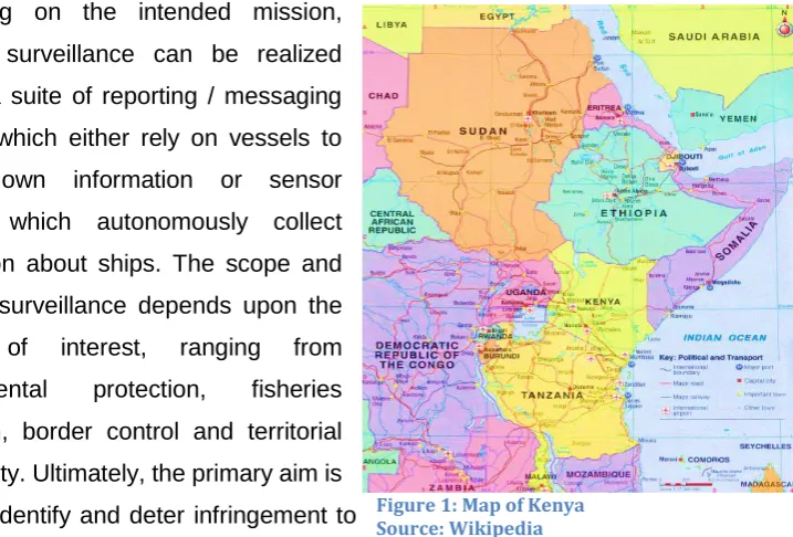
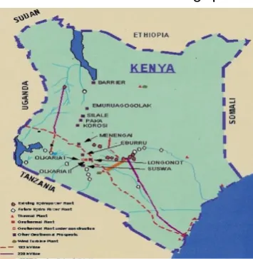
The approach to ports, coastlines and navigation channels constitute vital transportation infrastructure that require protection from a myriad of risks and challenges. Kenya has 614 Km. of coastline and 143,000 km2 of Exclusive Economic
Zone (EEZ) (IHO- Kenya National Report to South African and Islands Hydrographic Commission (SAIHC), as well as a busy shipping lane and remote islands, as depicted in figure 1 below. According to the European Commission’s (EC) Joint Research Centre, “Surveillance is a key element to exercise national sovereignty at sea” (2008, EC Joint Research Centre). These sea areas require continuous surveillance and protection.
Depending on the intended mission, maritime surveillance can be realized through a suite of reporting / messaging systems which either rely on vessels to provide own information or sensor systems which autonomously collect information about ships. The scope and mode of surveillance depends upon the domain of interest, ranging from environmental protection, fisheries protection, border control and territorial sovereignty. Ultimately, the primary aim is either to identify and deter infringement to
regulations or to ensure safety and security. Africa’s coastline, measuring around 30,500 km is confronted with a myriad of challenges. “The vastness of Africa’s maritime domain provides great opportunity for exploitation by terrorists. Terrorist
2
activities therefore constitute a latent threat….” (O.S Ibrahim, 2009). This complicates the maritime surveillance challenges, and calls for complete paradigm shift from the traditional approaches to more proactive and security-focused approach.
Large portions of Kenya’s coastline are very remote and lack reliable communication infrastructure, mainly attributed to lack of connection to the national power grid. At the peak of the piracy menace off Somalia waters, numerous acts of piracy were staged on vessels destined to the port of Mombasa. Such sporadic attacks also targeted fishing boats and dhows, which were then used to further orchestrate the crime (use of mother boats). Between 2013 and 2015, virtually no successful acts of piracy were reported within waters of this region (IMB Piracy Reports on trends of piracy).
However as recent reports show, piracy is still a huge regional challenge because underlying causes, such as illegal fishing and dumping in the Somalia piracy context remain unresolved. The economic cost of maritime piracy is on an upward trajectory, as Somali pirate networks resume attacks on ships. According to a recent report by “Oceans Beyond Piracy” Group, the cost attributable to piracy in Somalia increased to 1.7 Billion Dollars in 2016, from 1.3 Billion Dollars in 2015. This includes costs paid by shipping operators for increased insurance, labour, armed guards and other protection measures, as well as ransoms paid by insurers and the cost of naval deployments. So far in 2017, there have been two high-profile hijackings by Somali pirates: The Aris Tanker in March and an Indian flagged commercial ship in April (Oceans Beyond Piracy, 2017)
3
necessary, and focus seems to be gravitating towards Maritime Domain Awareness (MDA)1.
The sea route bordering the State of Somalia and through the Horn of Africa, is very critical for global trade. International Maritime Organization (IMO), European Union (EU), United States of America (USA) and Regional Governments have made heavy investment in capacity building and technology transfer to make this sea area safe. Under the Global Search & Rescue (SAR) arrangements, Kenya has obligations relating to Search and Rescue coordination over an expansive portion of this sea area as well as 614 km of immediate territorial coastline dotted with a number of small remote islands. A thriving community of fishermen, with generally good understanding of local maritime environment and well-organized Beach Management Units (BMUs), dominates these remote islands. This fishing community can be engaged for proactive roles in maritime situational awareness. However, this capability can be impeded by lack of constructive engagement and poor state of communication infrastructure.
According to a 2013 Watercraft and Baseline Survey Report by Kenya Maritime Authority (KMA) there are 206 fish landing sites along Kenya’s Indian Ocean Coastline, with a substantial number of these in private hands. Out of 16,805 surveyed watercrafts, 1894 were anchored and operated on privately owned sites. Given the remoteness of most of these regions, security ramifications can be severe.
Therefore, analysis of the status of existing maritime surveillance forms the gist of this research undertaking. The immediate motivation is to establish the potential for renewable energy solutions in addressing communication gaps, hence improving maritime situational awareness in the areas.
1.1 Research objectives
Despite the compelling need for functional maritime surveillance systems to improve security situation in sea routes and archipelagic waters around Kenya’s Indian Ocean coastline, the challenges relating to power source have not come to a fruitful end. In seeking a solution, this thesis will:
4
a. Explore the viability of wind and solar power harvesting in these remote Islands for applications in maritime surveillance systems.
b. Then assess how the identified, viable renewable energy options can be effectively used to power maritime surveillance equipment.
c. Analyze the existing surveillance structure in the context of evolving maritime challenges in the region, and how renewable energy can deliver improvements.
1.2 Research questions
For an exhaustive investigation of the topic, answers to the following research questions are sought:
a) Can renewable energy technologies be harnessed for application in maritime surveillance systems in Kenya’s remote Coastal Islands?
b) Are there additional measures and facilities that can deliver improvements to Kenya’s overall Coastal Surveillance arrangements within the constraints of the maritime administration and civilian stakeholder agencies’ capabilities?
Furthermore, an in-depth analysis of the current operational structure of maritime surveillance will lead to improved understanding of gaps that need to be addressed. In this context, the research questions are,
c) What are the inherent risks of weak maritime surveillance in these remote coastal Islands? Based on case studies of successful implementations of maritime surveillance systems, how will the envisaged improvements to the maritime surveillance system enhance incident reporting and response capability in these areas?
1.3 Research Methodology
5
laboratories (NREL), the International Renewable Energy Agency (IRENA) and the World Energy Council.
Several company documents and expert references were also perused for data on the research topic. Information on the current vessel reporting systems and maritime surveillance arrangements was obtained from Kenya Maritime Authority and Mombasa Regional Maritime Rescue Coordination Centre (RMRCC). Information on the international legal framework and maritime security reports was sourced from the International Maritime Organization (IMO), the Baltic and International Maritime Council (BIMCO), North Atlantic Treaty Organization (NATO) Shipping Centre, International Chamber of Shipping (ICS), International Maritime Bureau (IMB) and Oceans Beyond Piracy.
A practical field survey covering the whole stretch of the Kenyan coastline is included. The physical survey was limited to obtaining GPS coordinates, area elevation above sea level and assessing accessibility. GPS data and area elevation are essential parameters for ascertaining conditions for effective Very High Frequency (VHF) triangulation. This thesis is organized in three thematic areas. The first part discusses renewable energy technologies, with a focus on the economic drivers surrounding renewable energy applications in maritime surveillance. The second part broadly examines maritime surveillance from the standpoint of facilities and arrangements at the disposal of the Maritime Authority and Civilian Agencies in Kenya. The third part analyses the current scenario and arrangements, and concludes with recommendations for the improvement of maritime surveillance.
1.4 Thesis outline
Chapter 1 contains a synopsis of this dissertation task, highlighting the nature of the problem, objectives of the study and the research scope. Chapter 2 is an extensive literature review of contemporary applications of renewable energy technologies and Kenya’s policy framework on renewable energy.
6
context of national, regional and international obligations and arrangements are also examined.
Chapter 4 discusses Kenya’s multi-agency approach to maritime surveillance, and civilian agencies’ input with respect to maritime safety and security. These are weighed in terms of their adequacy to the huge regional challenge of piracy and maritime crime. Reported maritime incidents are analysed to establish correlation between absence of robust maritime surveillance and the preponderance of incidents. The causal mechanisms approach is applied.
Chapter 5 features a case study pertaining to the successful implementation of maritime surveillance. It examines how Papua New Guinea (PNG), with a coastline measuring 20,197 km and EEZ covering 3,120,000 km2, has successfully
implemented a surveillance system fully powered from renewable energy sources. The chapter delves into the scope for improvement in Kenya’s surveillance arrangements, by juxtaposition to the PNG system. This is followed by a consolidation of the main outcomes and assumptions, into a coherent and focused roadmap for the overall improvement of maritime surveillance. Conclusions and recommendations drawn from the study are presented in this chapter.
1.5 Delimitations.
7
2 CHAPTER 2
2.1 Literature Review
This chapter reviews some studies so far undertaken on renewable energy. The focus is on the economic considerations pertinent to planning and uptake of renewable energy for maritime surveillance applications in remote coastal islands. Generally, prospects for the application of renewable energy technologies across many facets of human endeavours appear bright. The Renewable Energy Policy Network for the 21st
Century (REN21) reported in 2016 that 44 million off-grid pico-solar products had been sold globally by mid-2015, representing an annual market of 300 million US Dollars. There are huge prospects for maritime surveillance systems to tap into the fast expanding renewable energy sector.
2.2 Renewable Energy
Renewable energy is a concept that is fast capturing global attention. It has been variously described, as energy from a source that is not depleted when used, and according to “Dictionary.com”, it is “any naturally occurring, theoretically inexhaustible source of energy for instance biomass, solar, wind, tidal wave and hydro, that is not derived from fossil or nuclear fuel” (Dictionary.com)
A more concise and encompassing definition is by Islam et al, (2014) which states that renewable sources are “those that are abundant in nature, and derived from natural processes with no depletion in the course of utilization” (Islam, Shahir, Uddin, & Saifullah, 2014).
8
energy sources. The approach emphasized attention to site-specific environmental aspects.
Weisser (2004) analysed the dynamics of power generation in Small Island Developing States (SIDS) and extolled the unique characteristics in SIDS that make fossil fuel-based electricity generation very costly. He emphasized the need for paradigm shift in energy planning. The conclusions of his study immensely lend themselves to the scenario under review in this thesis.
Bergmann et al. (2006) evaluated external benefits and costs with respect to renewable energy investment. Although the study was based on the Scotland scenario, the conclusions on external costs and benefits to be considered for optimal investment in renewable energy options have universal applicability. Mondal et al. (2010) analysed the drivers, barriers and strategies for implementation of renewable energy technologies in rural areas in Bangladesh, through an innovative approach with immense applicability in developing regions with similar circumstances.
2.3 Renewable Energy Potential
To maximize the benefits obtainable from a renewable energy technology in a country, it is important to weigh the technology in the context of existing energy strategies and plans, financial, institutional as well as legal frameworks. J. P. Painuly, (2000) proposed three dimensions upon which to gauge potential: technological potential, techno-economic potential and economic potential.
2.4 Costs and Trends in Renewable Energy uptake
9
In a similar assessment, the Renewable Energy Policy Network for the 21st Century
(REN21) concluded that: “Rapid growth, particularly in the power sector, is driven by several factors, including the improving cost competitiveness of renewable energy technologies, dedicated policy initiatives, better access to financing, energy security and environmental concerns as well as growing demand for energy in the developing and emerging economies” (REN21, 2016).
2.5 Levelised Cost of Electricity (LCOE)
The World Energy Council defines LCOE as the price that has to be received per unit of output as payment for producing power, in order to reach a specified financial return or put simply “the price that a project must earn per megawatt hour in order to break even.” (World Energy Council, 2013).
According to the Frankfurt School FS-UNEP Collaborating Centre for Climate change and Sustainable Energy Finance, (2017) it is the “all-in one cost of generating each MWh of electricity from a power plant, including not only fuel used, but also the cost of project development, construction, financing, operation and maintenance”. (Frankfurt School FS-UNEP Collaborating Centre, 2017)
Analytically, LCOE2 is denoted by:
𝐿𝐶𝑂𝐸 = Lifecycle Cost ( $)
2𝑎𝐿𝑖𝑓𝑒𝑡𝑖𝑚𝑒 𝑃𝑟𝑜𝑑𝑢𝑐𝑡𝑖𝑜𝑛 (𝑘𝑊ℎ) … … … 𝐸𝑞𝑢𝑎𝑡𝑖𝑜𝑛 1
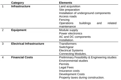
LCOE Computation
Based on National Renewable Energy Laboratories’ (NREL) Solar‐PV Manufacturing Cost Model, the Plant envelope incorporates the following elements
10
Table 1: LCOE Elements
Category Elements
1 Infrastructure Land acquisition
Site preparation
Installation of underground components Access roads
Fencing
Operations buildings and related maintenance
2 Equipment Module supply
Power electronics AC and DC components Installation.
3 Electrical Infrastructure Transformers Switchgear Electrical Systems Connecting Modules.
4 Financial Costs Preliminary Feasibility & Engineering studies Environmental studies
Permits Legal Fees Insurance costs Development Costs
Property taxes during construction.
.In this study, a Levelised Cost of Energy calculator was used to compare the LCOE cost of 17 technologies. The results and excel extract are included in appendix. For solar power the LCOE is US$ 85/MWh while for onshore wind, it is US$ 58/MWh.
2.5.1 Capital Expenditure (CAPEX) and Operating Expenditure (OPEX)
The World Energy Council defines CAPEX as the total cost of developing and constructing a plant, excluding any grid-connection charges. Feldman et al, (2015) and also Beamon and Leff, (2013), view CAPEX as representing the total expenditure required to achieve operation in a given year. On the other hand, OPEX is “the total annual operating expenditure from the first year of a project’s operation, given in per unit of installed capacity terms.” (World Energy Council, 2013).
2.5.2 Capacity factor (Load Factor)
11
generated at continuous full-power operation, or 8,760 (per annum) full hours” (World Energy Council, 2013).
2.5.3 Society’s Cost of Energy.
This ascribes a much broader scope to the cost of energy, by taking into account factors such as the number of jobs created by energy source, subsidies, transmission costs, variability costs, geopolitical risk impact, besides also taking into account the Levelised Cost of Energy (LCOE). It was proposed by Siemens “to measure the true cost of electricity generated by various sources” (Siemens AG, 2014)
2.5.4 Maritime Surveillance Systems powered by Solar and Wind:
Several studies have been undertaken to establish the suitability of renewable energy for powering up surveillance systems in remote areas lacking connection to the national power grid. In 2011, the Border and Maritime Security Division (BMD) of the United States (US), the U.S. Department of Energy (DOE) and National Renewable Energy Laboratories (NREL) conducted a joint study on border-security energy demands. The rationale of their study was to ensure that advances in renewable energy and energy storage would be reflected in improved security situation..
They summarized the factors that make renewable energy particularly attractive for applications in maritime surveillance and border security, including the following: Operational continuity arising from grid failure. Installed renewable energy sources can sustain critical loads until grid service is restored. The greater the proportion of renewable energy technologies, the longer the operations can be sustained without grid power.
12
On the other hand, aging energy infrastructure poses a threat to national security. Electricity generated near the load reduces reliance on the grid infrastructure, thereby eliminating the operational burden relative to the grid infrastructure. Renewable energy offer strategic advantages by helping hedge against volatile fuel prices and supply interruptions, as well as reducing dependence on fossil fuels supplied from regions of conflict. Renewable energy technologies are also clean, sustainable and mostly emission-free.
To ascertain whether the power requirements of a given surveillance system can be met from renewable sources, it is necessary to establish the operational energy profile of the unit, in terms of peak power consumption, the duration of consumption (volts (V), amps (A), watts (W), phase, and whether it draws alternating current or direct current. It is also necessary to establish whether the unit is optimized for off-grid deployment, whether there is need for emergency backup and if so, the redundancy level necessary.
2.5.5 Solar Energy
Solar Energy can be processed either through Photovoltaic (PV) systems that directly convert the solar energy into electrical, or Concentrated Solar Power (CSP) systems which first convert the solar energy into thermal energy, then onwards to electrical engine through a thermal engine.
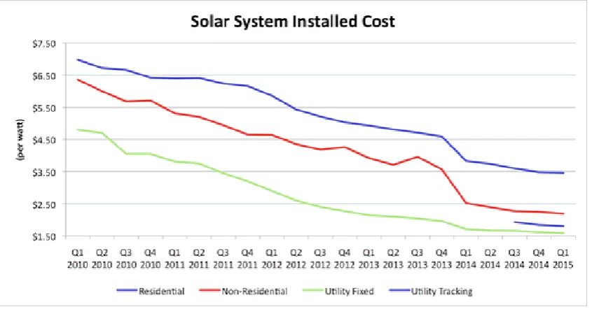
13
Figure 2: Solar System Installed Cost: Worldwide Trend Source: IRENA, 2017
Table 2 below provides a snapshot of typical efficiency figures for thin film and wafer technologies in the category of Commercialized PVs.
Table 2: Solar PV Technologies, Source: NREL
PV technology Variation & Properties Efficiency
1 Thin Film Lower cost per unit of power produced
Amorphous Silicon 7% Cadmium Telluride 11% Copper, Indium, Gallium,
Selenide (CIGS)
11%
2 Wafer PV Have greater efficiencies than thin film technologies
14% to 20%
3 Multi-junction PV Capture different spectra of light, thus increasing overall efficiency of the composite system.
Up to 30% efficiency in systems that concentrate sunlight by up to 500 times
2.5.6 Photovoltaics
14
of stealth. Some of the shortcomings cited with respect to photovoltaics include their requirements for additional equipment such as inverters to convert DC to AC, storage batteries for on-grid connections and the fact that land mounted PV panels require relatively large areas for deployment, thereby committing the land for 15 to 20 years or longer. PVs also feature relatively low efficiencies (between 14 to 25%) compared to other renewable energy technologies. PV panels are fragile and susceptible to easy damage, necessitating additional overheads on insurance costs.
2.5.7 Wind
According to the NREL, the economic viability of a wind project depends on the cost of the wind resource compared to that of electricity. A strong wind resource (Class 5 and Class 6) can compete against electricity. A modest wind resource (Class 2 and Class 3) can compete against high-priced electricity. According to NREL, “the high cost of electricity in an environment where there is strong wind makes wind a compelling option with a short payback” (NREL, 2016)
Over the past decade, wind energy has experienced annual growth rates in installed capacity of more than 30%. The wind industry has several distinct sectors, each characterized by specific technology and deployment strategies. Each of these wind sectors essentially envisage different technologies, assessment methods, economics, environmental considerations, and factors that serve as the drivers for those sectors. According to NREL, “There is no one design or size that is “the best in all applications”; rather, there are applications that favor certain sizes and designs, as they provide the better relative economics and performance within the application driven constraints” (NREL, 2016).
2.5.8 Wind Power
15
P = A Ρv3/2
Where;
P = power of the wind (watts)
A = windswept area of the rotor (blades) = πD2/4 = π r2 [m2] (π r2 [10.76 ft2])
ρ = density of the air [kg/m3] (2.2 lb/3.28 ft3) (at sea level at 15°C)
V = velocity of the wind [m/s] (3.28 ft./sec)
Wind power (P) is proportional to velocity cubed (V3). If wind velocity is doubled, wind
power increases by a factor of eight (23 = 8). Consequently, small differences in
average speed cause significant differences in energy production.
2.5.9 Hybrid Photovoltaic/ Wind Energy plus Battery System:
Hybrid renewable energy projects involve the siting of different renewable energy projects within the same location: like solar and wind, or solar thermal and geothermal. The main attraction here includes the ease of distribution resulting from the sharing of one grid connection, production of more electricity per hectare of land, economy in operating and maintenance costs, and reduction of overall intermittency. “Mini grids are particularly viable in developing countries and on remote Islands especially with wind and solar or wave paired with batteries or even diesel back-up generators” (Frankfurt School (FS)-UNEP Collaborating Centre for Climate Change and Sustainable Energy Finance, 2017)
Various researchers have evaluated Hybrid Renewable Energy Systems (HRES) using different methods such as energy to load ratio, battery to load ratio, and non-availability of energy. In order to select an optimal combination of a HRES to meet the demand, evaluation may be carried based on reliability and economics of power supply.
16
worldwide. There is huge potential for this number to grow significantly in the years ahead, as developers take advantage of synergies from co-locating two or more technologies.
2.6 Hybrid Optimization Model for Electric Renewables (HOMER) Software.
HOMER renewable energy optimization software application, developed by the National Renewable Energy Laboratory (NREL) in the United States, is helpful in designing and evaluating technical and financial variables for off-grid and on-grid power systems in remote, stand-alone and distributed generation applications. The software enables assessment of a large number of technology options to account for energy resource availability and other variables.
Using the HOMER software a user can input an hourly power consumption profile and match renewable energy generation to the required load. Okedu et al, 2014 summed up the powerful tools unleashed by HOMER software: “it allows a user to analyze micro-grid potential, peak renewables penetration, ratio of renewable sources to total energy, and grid stability, particularly for medium to large scale projects. Additionally, HOMER contains a powerful optimizing function that is useful in determining the cost of various energy project scenarios” (Okedu & Uhunmwangho, 2014)
The HOMER software simulates real technological scenarios in renewable energy, providing very detailed results for analysis. It enables the determination of possible combinations of technologies and sizes, hence powerful tools for optimization. On the flip side, its accuracy entirely depends on the quality of input data. In terms of the research topic under review, the HOMER software can provide convenient metrics for comparing between the various power generating technologies, without practically engaging the rigorous field research process.
2.7 Renewable Energy technologies for Maritime Surveillance applications
17
systems. The second scope covers maritime surveillance equipment, primarily powered by solar, with wind as a standby source (similar to the system used by Papua New Guinea3 )
The assessment of prospects for stand-alone wind/ solar power generation in remote Islands of Kenya necessitates an analysis of the environment, the regulatory context of renewable energy generation in Kenya and cost aspects such as LCOE, CAPEX, OPEX and Capacity Factor.
2.8 Energy situation in Kenya:
According to Kenya’s Energy Regulatory Commission, Kenya’s energy mix consists of biomass (68%), hydrocarbons (22%), electricity (9%), solar and other forms of energy (1%), with petroleum and electricity dominating the commercial energy sector. “As at June 2015, Kenya had an installed electricity generation capacity of 2,299MW” (Energy Regulatory Commission Annual Report, 2016). This energy mix is depicted in figure 3 below, which projects the relative significance of each source in the country’s overall energy mix.
Figure 3: Kenya's Energy mix
3 Papua New Guinea Maritime Surveillance System is analysed in chapter 5
Energy Type %
Biomass
Hydrocarbons
Electricity
Solar & Others
Total Electricity generated 2299 MW
Hydro
Thermal
Geothermal
18
2.8.1 Management of the Energy Sector in Kenya
Several Government bodies are responsible for management of the energy sector in Kenya. These are listed in table 3 below. Overall operation and administration of the sector is under the remit of the Ministry of Energy & Petroleum.
Table 3: Government Bodies responsible for Energy Management in Kenya
Government Bodies
Body Mandate
1. Ministry of Energy and Petroleum
Provides policy direction and prepares the least cost energy development plan for the whole country.
Operates four Directorates, reflecting the various forms of energy sources. These are Electric Power, Renewable Energy, Geothermal, Oil and Petroleum.
2. Energy Regulatory Commission, (ERC)
Established through the energy Act 2006- provides technical, economic and regulatory oversight on the energy sector in Kenya.
3. Rural Electrification Authority (REA),
Incorporated in 2007- has the mission to implement rural electrification program.
4. The Energy Tribunal Has responsibility for arbitration between the Energy Regulatory Commission (ERC) and aggrieved stakeholders in the energy sector.
Electricity (Power) generating companies
1. Kenya Generating Company (KenGen)
Generates 76% of the total country output, equivalent to 1238 MW. It is government owned.
2. Independent Power Producers (IPPs)
Generate 24% of the total energy produced, equivalent to 391 MW.
Distribution
1. Kenya Power & Lighting Company (KPLCo)
Distribution of electricity to end users/ retailing.
2. Kenya Electricity Transmission Company (KETRACO)
Incorporated in 2008- is responsible for planning, designing, constructing, owning, operating and maintaining new high voltage (>132 KV) transmission grid and regional interconnections.
3. Geothermal Development Company (GDC)
19
2.8.2 The National Regulatory Framework on Renewable
Energy Regulations in Kenya are anchored in Sessional Paper No: 4 of 2004,the Energy Act of 2006, Energy Policy of 2004, which lays the foundation for the current energy policy and the Feed-in Tariffs policy of 2008 (Revised in 2012), which together encourage electricity generation through renewable sources. A key pillar with regard to renewable energy is the Feed-in Tariff policy (FiT) initiated in 2008, which provides investment security and market stability for investors while motivating private investors towards renewable energy
technology.
The National Climate Change Response Strategy enacted in 2014 aims to strengthen and focus nationwide actions towards climate change adaptation and GHG emission mitigation. Another important feature is the zero-rating of import duty and removal of Value Added Tax (VAT) on renewable energy equipment and accessories.
2.8.3 Kenya Electricity Grid Network:
The national grid network in Kenya comprises over 30400 km of both transmission and distribution lines, made up of some 1323 km of 220 kV lines, 3767 km of 132 kV and 630 km of 66 kV lines. Figure 4 below depicts the transmission network (Solar & Wind Resource Assessment- Kenya)
According to a study report dubbed “Scaling-Up Renewable Energy Program (SREP) Joint Development Partner Scoping Mission, February 7-11, 2011”,: “inadequate
power supply and weak electricity network infrastructure is a brake on Kenya’s economic performance and threatens Kenya’s ambition set out in its overarching development program (Vision 2030) to be a middle-income country by 2030”
Figure 4: Electricity Grid Network in Kenya
20
(Government of Kenya, 2011). This provides further impetus to the need to consider self-sustainable off-grid sources for critical infrastructure.
2.8.4 Renewable Energy potential in Kenya:
In its 2002 Kenya Country Report, the Solar and Wind Resource Assessment (SWERA) projected that about 25% of the country was compatible with current wind technology. Along the coast, the wind resource varies between 5-7 m/s at 50 metres height. This finding reflects the fact that Kenya, generally, and her coastal region in particular, is endowed with adequate wind resources
21
3 CHAPTER 3
3.0 Maritime Surveillance
Maritime surveillance involves the application of various tools and techniques to monitor a state’s territorial waters and Exclusive Economic Zone (EEZ). Dalaklis, 2016 viewed maritime surveillance from two perspectives:
NATO perspective: Maritime Situational Awareness (MSA) is “the understanding of military and non-military events, activities and circumstances within and associated with the maritime environment that are relevant for current and future NATO operations and exercises -where the Maritime Environment (ME) is the oceans, seas, bays, estuaries, waterways, coastal regions and ports” (Dalaklis, 2016)
IMO perspective:Maritime Domain Awareness (MDA) is “the effective understanding of anything associated with the maritime domain that could impact the security, safety, economy, or environment”. In the later definition, the maritime domain includes all areas and things of, on, under, relating to, adjacent to, or bordering on a sea, ocean, or other navigable waterway, including all maritime related activities, infrastructure, people, cargo, and vessels and other conveyances” (Dalaklis, 2016)
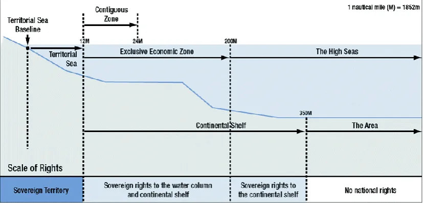
3.1 Legal basis for Maritime Surveillance:
22
Figure 5: Maritime Jurisdictions
As provided for in UNCLOS, a Coastal State has exclusive rights to undertake monitoring and surveillance in connection with economic exploitation and exploration of its EEZ. Further, all States have the implied right to undertake monitoring and surveillance in the high seas, subject to not interfering with the exercise of the freedom of the high seas by ships flying a foreign flag. Search and Rescue (SAR) regions, with purely functional purpose and no correlation with maritime zones claimed pursuant to UNCLOS, constitute an important basis for maritime surveillance.
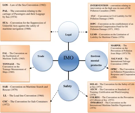
3.2 IMO instruments pertaining to the safety of shipping
23
Figure 6: IMO Conventions Courtesy: Dalaklis, 2016
In the context of this study, the SAR Convention and the SOLAS Conventions embody the international regulations that underpin maritime surveillance. SOLAS Convention covers equipment specification, while the SAR Convention lays down the operational framework for maritime surveillance. In Kenya, IMO Conventions are enshrined in the Merchant Shipping Act, 2009, following domestication of the IMO Statutes by Kenya.
IMO
Legal Environ mental protectio Safety TradeLOS – Law of the Sea Convention (1982)
PAL – The convention relating to the carriage of Passengers and their Luggage by Sea (1974)
SUA – Convention for the Suppression of Unlawful Acts against the safety of maritime navigation (1988)
SAR – Convention on Maritime Search and Rescue (1979)
LL – The Load line Convention (1966)
CSC – The Convention for Safe Containers (1972)
SOLAS – The Convention for the Safety of Life at Sea (1974)
STCW – The Convention on Standards of Training, Certification and Watch keeping (1978)
COLREG – The Convention on the Prevention of Collision at Sea (1972)
INMARSAT – The Convention on the International Maritime Satellite Organisation (1976)
MARPOL – The Convention on the Prevention of Pollution from Ships (1973/78)
SALVAGE – The International Salvage Convention (1989)
OPRC – The Convention on Pollution Preparedness, Response and Cooperation (1990)
FAL – The Convention on the Facilitation of Maritime Traffic (1965)
TONNAGE – The Convention on the Tonnage Measurement of Ships (1969)
INTERVENTION – convention relating to intervention on the high seas in cases of Oil Pollution Casualties (1969)
CLC – Convention in Civil Liability for Oil Pollution Damage (1969)
IOPC - Convention on the establishment of an International Compensation Fund for Oil Pollution Damage (1971, 1992)
24
3.3 Surveillance systems
Surveillance systems include visual sightings, still cameras, closed circuit television (CCTV), radar and infrared imaging. Such systems and techniques are pivotal in the construction of a maritime picture in situations where either data is not provided under a reporting regime (whether deliberately or not), in respect of (typically smaller) vessels that are not subject to a reporting regime.
3.3.1 Military surveillance systems
Gathering of surveillance data is an integral component of the roles undertaken by navies for defense purposes. This came in the aftermath of the International Ship & Port Security (ISPS) Code - primarily designed to deter terrorism. Ascertaining precise amount and scope of data within the purview of military surveillance is not easy, owing to the confidentiality that surrounds this. Nonetheless, standard modes of gathering such data include physical observation from military vessels and aircraft, unmanned vehicles and drones, remote sensing, coastal radars, and underwater sensors. Military surveillance systems are characterized by their robustness and rigorous energy requirements.
3.3.2 Commercial Surveillance and Ship reporting systems
These feature less stringent requirements in terms of robustness and energy consumption, but are applied to fulfil specific monitoring or surveillance needs. Ship reporting systems include LRIT (Long Range Identification and Tracking) as mandated by IMO via SOLAS chapter V, Regulation 19-1 in 2008, AIS (Automatic Identification System) by the International Telecommunication Union (ITU) vide: ITU-M 1371, 2014 (Rev) and Vessel ITU-Monitoring System (VITU-MS) for fishing vessels, mandated by the Food and Agriculture Organization (FAO) - 1998, plus non‐automatic reporting through transceiver radio call‐in.
25
they are going: i.e. to know the Maritime Situational Picture” (Greidanus, et al., 2013). This requirement is consistent with obligations pertaining to maritime safety and security.
Popa, (2011), analysed the success of LRIT in addressing the challenge of piracy, while Chen, (2014) made a comprehensive comparison between LRIT and Satellite – based AIS in terms of costs, communications scheme, coverage, information scope and credibility and emphasized the complementary roles delivered when both systems are operated concurrently.
Ship reporting systems are provided for in Regulation 11, Chapter V of SOLAS. Several ship-reporting regimes are incidental within European waters. These include mandatory systems that apply to specific stretches of water, general obligations to notify the Ports of destination, and reporting regulations under Vessel Traffic Services (VTS).
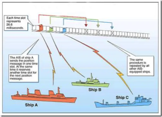
3.3.3 Automatic Identification System (AIS)
Based on Regulation 19 of Chapter V of the International Convention for the Safety of Life at Sea (SOLAS), AIS is mandatory for all vessels of 300 GRT and above on international voyages, cargo ships of over 500 Gross Registered Tons (GRT), and passenger vessels irrespective of size. Warships and government owned vessels are exempted.
26
and navigational status, plus manually entered static data. The messages are transmitted un-encrypted over open frequencies (161.975 MHz & 162.025 MHz for terrestrial communications and 156.775 MHz & 156.825 MHz for satellite communications) (ITU-R, 2012) hence allowing everyone with suitable equipment to receive it. AIS reduces the workload for authorities tasked with monitoring and controlling coastal and offshore vessels calling at Ports. The slot mapping architecture of the AIS system is based on Self Organized Time Division Multiple Access (SOTDMA), depicted in figure 7 above.
3.3.4 Long Range Identification and Tracking (LRIT)
LRIT is a collection and distribution system for basic information on vessels. Following IMO’s adoption of amendments to SOLAS chapter V, Regulation 19-1 in 2008, LRIT regulations apply to the following ships engaged on international voyages: all passenger ships including high speed craft, cargo ships, including high speed craft, of more than 300 GRT, and mobile offshore drilling units. These categories of vessels are required to automatically transmit their identity, position, and time at six hourly intervals, with the ability to increase this rate to once every fifteen minutes when requested while on international voyages.
27
SOLAS Contracting Governments bear operating costs of the system. The system allows member States to receive position reports from vessels operating under their flag, vessels seeking entry to a port within their territory, and vessels operating in proximity to a Member State’s coastline (up to within 1000 nm). Besides enhancing security and environmental protection, LRIT offers safety/search-and-rescue benefits. The system architecture is depicted in figure 8 below.
Figure 8: LRIT System architecture,
Source: International Mobile Satellite Organization (IMSO)
3.3.5 Very High Frequency (VHF) Digital Selective Calling (DSC)
28
3.3.6 Maritime Safety and Security Information System (MSSIS)
The Maritime Safety and Security Information System (MSSIS) is an unclassified, near real-time AIS data collection and distribution network. It promotes collaboration and data sharing among international participants, with the primary goal of increasing maritime security and safety. Data sources may range from a single sensor to an entire national vessel-tracking network.MSSIS enables password-protected, Internet-based sharing of AIS data using encrypted data links.
The client software for MSSIS runs on Trans view (TV32), providing a common system interface and vessel tracking display for users. Apart from a suite of standalone display features, it also serves as a platform for users to access and contribute to the aggregated, global data.
3.3.7 Automated Mutual Assistance Vessel Rescue System (AMVER)
AMVER is a worldwide voluntary vessel reporting system operated by the US Coastguard to promote safety of life at sea. Mooted in the wake of the Titanic disaster in 1912, AMVER’s main contribution is to quickly provide Search and Rescue Authorities with accurate information on the positions and characteristics of vessels near a reported distress.Request for AMVER assistance with respect to a vessel in
29
distress is sent to the US Coast Guard. The request should specify position, vessel’s details, the center and radius, and request for SURPIC (surface picture). The US Coastguard promptly faxes back the result, with a rich amount of detail regarding ships within vicinity of the distressed craft from whom assistance may then be promptly sought, in tandem with GMDSS distress response procedures.
3.3.8 Vessel Monitoring System (VMS):
Vessel monitoring systems help fisheries administrations to monitor vessel position, course and speed, with a view to ensuring fishing vessels are doing the right thing. It is one of the most widespread cooperative surveillance tools currently used for fisheries management. A VMS system incorporates a transceiver unit that transmits its GPS coordinates via a communications satellite to a monitoring station ashore. Currently VMS uses satellite GPS technology that provides position data within 10 m resolution globally. While there are currently no binding global agreements regarding the use of VMS, most Regional Fisheries Management Organizations (RFMOs) as well as many States have mandated its use on larger commercial fishing vessels.
3.3.9 Vessel Traffic Service (VTS)
30
4 CHAPTER 4
4.0 Management of Kenyan waters.
Management of Kenyan waters is a shared responsibility among several Government Agencies, with Kenya Maritime Authority (KMA) having the lead role in regulatory aspects. KMA collaborates with several government bodies like the Kenya Ports Authority (KPA), Ministry of Fisheries, Kenya Maritime Police Unit, Kenya Ferry Services Ltd, Kenya Wildlife Services (KWS) and Kenya Navy among others. Maritime policies provide a framework that guides the growth of the sector while ensuring compliance with international and institutionalized approach to maritime issues. Each Agency’s mandate is stipulated in their respective enabling Acts. KWS’ main role involves protection and conservation of the marine environment in the five gazetted national marine parks and reserves through the Wildlife Conservation and Management (Amendment) Act, 1989. The Kenya Navy mans and patrols the EEZ against external aggression and illegal activities besides offering support in search and rescue operations for persons in distress at sea. The Kenya Maritime Police unit patrols the territorial waters, and supports search and rescue activities at sea. The Unit was established in April 2007 as a law enforcement agency to deal with maritime activities to provide security along the seas and lakes in Kenya.
4.1 The Institutional framework for Maritime Safety & Security in Kenya.
31
Lead Government Agency Maritime Security component
Kenya Maritime Authority Maritime Search & Rescue and Pollution control
Kenya Navy Patrolling / securing Kenya’s EEZ
Kenya Ports Authority VTMS and Mombasa port compliance with ISPS code
Kenya Wildlife Services Preservation of marine environment/ Law enforcement capabilities.
Kenya Maritime Police Unit Patrolling territorial waters/ Law enforcement Kenya Revenue Authority Border control/ Prevention of contraband goods Kenya Fisheries Prevention of illegal fishing activities
Immigration Department Border control & prevention of illegal immigrants
Criminal Investigations Department Investigations/ prosecution
National Security Intelligence Services Gathering of intelligence related to piracy/ terrorism.
4.2 The regulation of watercraft in Kenya.
The existing regulatory framework incorporates rules and guidelines for safety, security and protection of the environment and registration, certification, licensing and authorization documents, which govern the management of the maritime sector. The enshrining documents include:
1. The Merchant Shipping Act 2009, (Revised 2012)
2. The Kenya Maritime Authority Act 2006 – Cap No. 5 of 2006, 3. The Fisheries Act, 1989 –Cap 378 - August 1989
4. The Fisheries (Beach Management Unit) Regulations, 2007 5. The Ports Authority Act, 1987-Cap 391 - January 1978 6. The Ferries Act-Cap 410, October 1936
32
8. Lakes and Rivers Act-Cap 409, December 1930
4.3 Kenya Maritime Authority (KMA)
Kenya Maritime Authority (KMA) was incorporated in June 2004 as a semi-autonomous agency with regulatory oversight over the Kenyan maritime industry. It operates under the Ministry of Transport and Infrastructure, with head office in the coastal city of Mombasa. Pollution control, Port and Flag State Control are among core functions of KMA (KMA Act, 2006). The Authority bears overall responsibility for the enhancement of Kenya’s regulatory and institutional capacities for maritime safety and security, effective implementation of international maritime conventions and other mandatory instruments relating to maritime safety and security. It is also responsible for the promotion of maritime training, coordination of Search and Rescue, prevention of marine pollution and promoting preservation of the marine environment besides generating an enabling environment for trade and maritime investment. These responsibilities are anchored in the Merchant Shipping Act, 2009 (amended in 2012). KMA has the mission to strengthen maritime administration in Kenya.
4.3.1 Mombasa Regional Maritime Rescue Coordination Centre (RMRCC)
Mombasa RMRCC was established following the Florence Conference 2000, which set up a Search and Rescue (SAR) Global Fund and recommended the establishment of five Regional SAR Centres to cover sea areas adjacent to the African continent (IMO, 2006). It was commissioned by the IMO Secretary General on 5th May, 2006,
in the implementation phase of the Florence 2000 recommendations, and became the first Regional Centre in Africa to be so established. The three Sub-Centres that operate under Mombasa RMRCC are Dar es Salaam, Seychelles, and Somalia Search region, which still has no GMDSS/ SAR infrastructure in place.
33
4.3.2 Operational roles of RMRCC Mombasa.
The Centre was commissioned as the Regional Maritime Rescue Coordination Centre (RMRCC) for the East Coast of Africa in May 2006. On 31st March, 2011 the Centre
took up additional roles as a Piracy Information Sharing Centre (ISC) within the framework of Regional anti-piracy grouping (Djibouti Code of Conduct).
Other delegated functions include collecting data on, and tracking vessels calling at the Port of Mombasa, receiving and maintaining a database on Kenyan registered/ owned dhows and their areas of operation as a strategy for enhancing Maritime Domain Awareness. Mombasa RMRCC maintains a 24/7 GMDSS watch and is fitted with a number of both Satellite and Terrestrial GMDSS and emergency communication facilities. The MMSI number of the Centre is 00 634 1000. The table below is a summary of equipment and cost data relative to the operation of the various systems and facilities from the RMRCC in Mombasa.
34
System Connection Platform Primary function Area of applicability Cost Implication to the Centre (US$) 1. LRIT Internet Vessel tracking 1000 NM and
global for flag vessels
Annual fixed cost @ 1,200 USD. Tracking expenses charged per vessels tracked.
2. AIS Vessel tracking 30 – 40 NM
within port vicinity
Quarterly maintenance
3. Electronic Chart (C-Map)
Internet Vessel location and Distance estimation
Worldwide Regular software updates 4. 111 Toll
free line
GSM Network Incident reporting by non-SOLAS vessels & fishing boats. Territorial waters, subject to GSM network coverage. Monthly ISDN standing charges @ 300 USD. Billing also done as per usage. 5. GMDSS
Console Radio communications & Satellite Alerting function and communication with vessels in distress
Sea Areas A1 to A4
Annual maintenance of equipment
6 Mercury System
Secure Internet Real time tracking and anti-piracy messaging and chats.
Closed system - Restricted to authorized entities.
Nil.
7. MSSIS Sea Vision
Satellite AIS delivered via Internet
Locating vessels of interest and safety related vessel tracking.
Global Nil
8. ISC VOIP Facility
Internet Voice
communication with other ISCs and National Focal Points on Piracy. Djibouti Code of Conduct Partner States and National Focal Points. Nil.
35
4.4 Discussion of the various systems and arrangements
The consolidated effect of the various facilities, arrangements, regulations and agreements give effect to Maritime Domain Awareness. Weaknesses in the various systems and arrangements are reviewed below.
The LRIT system obligates SOLAS Contracting Governments to bear operating costs of the system. The high cost of tracking vessels does not favour small flag states and tracking is only possible when the ship borne transmitter equipment is switched on. Vessel position reports are made available to other Member States for purchase, whenever a vessel is within 1000 nautical miles of the purchasing coast, or when a vessel seeking entry to a Member State’s port is at a pre-determined distance or time period from that port. When the LRIT system in Mombasa is activated on the 1000NM polygon, vessels as far away as the Gulf of Aden are tracked. This is depicted in the figure below.
36
The AIS System is primarily a collision avoidance system with a protocol that involves a simple and easily manipulated exchange of electronic data via unsecured connections. While vessels are obligated to transmit their position through the AIS, there is no system to validate whether the information transmitted is accurate (Windward Assessment Report, 2014). There are a number of loopholes in the system, which can be used to manipulate real world AIS/ Satellite data, including: neglecting to transmit a vessel’s final destination, shutting AIS transmissions, creating ‘Ghost ships’ and manipulating the GPS information.
Vessel Monitoring Systems (VMS): Due to its status as a cooperative system, VMS does not help much with IUU fishing and does not monitor non‐participating vessels. Vessels can also evade VMS regulations by registering with states which do not require its use, are not members of RFMOs that require its use, or which require VMS use but lack the will or capacity to enforce regulations. Vessels may also tamper with their VMS and disable the equipment, jam signals, or broadcast false position data.
Kenya has not yet operationalized VMS as a fisheries vessel-monitoring tool.
4.5 Maritime Surveillance challenges.
Wambua, 2010, examined the nature and severity of these challenges. In his assessment: “IUU fishing and maritime security issues stand out as the two main challenges that have had the greatest impact on the African nations and on the entire maritime world” (Wambua, 2010). The main challenges facing African states in their quest to bring order and sound governance to their maritime zones are summarized below:
1. Challenges pertaining to the delimitation of the maritime zones
2. Weak legal and institutional frameworks for governance of the maritime zones
3. Lackluster focus on training facilities and institutions to develop a pool of competent human resources for the governance process
4. Funding challenges for the exploration of and research on marine resources 5. Threat of marine pollution from land-based and ship-based sources
37
7. Piracy, armed attack against ships and hostage taking
8. Inadequate preparedness to deal with maritime Search and Rescue 9. Illegal immigration
10. Drug trafficking
11. Smuggling and contraband goods and arms 12. Inadequate port security
B. Hamand, 2016 conducted a study on maritime terrorism (why East Africa community is the next potential target of maritime terrorism) and observed that the terrorist activities in the East African Community (EAC) have so far been staged on land, and mainly in Kenya. The study concluded that “lack of a regional maritime security strategy (including a Maritime Domain Awareness program), unpoliced maritime waters and poor cooperation between Kenyan and Tanzanian maritime law enforcement agencies makes the region extremely vulnerable to maritime terrorism” (Hamand, 2017)
4.6 Maritime surveillance challenges in remote Islands: Causal Mechanisms
The Kenyan coastline extends for 614 km, stretching along four administrative Counties: Lamu, Malindi, Mombasa and Kwale and supports approximately 9,000 fishermen, directly through fisheries. According to the Kenya Marine Fisheries Research Institute (KMFRI) Kenya’s EEZ, measuring some 143,000 km2 is located
within the rich Tuna belt in the South Western Indian Ocean. Statistics gathered by the MRCC in Mombasa indicate that most of maritime incidents reported in Kenyan waters happen very close to the shore and in the Inland lakes and affect small vessels ferrying passengers and fishing community. These vessels are generally ill equipped with lifesaving and emergency communication facilities, but provide a source of livelihood for a significant proportion of the nation’s maritime community.