PRECISE GPS POSITIONING IMPROVEMENTS
BY REDUCING ANTENNA AND SITE DEPENDENT EFFECTS
Günter Seeber, Falko Menge, Christof Völksen
Institut für Erdmessung, Universität Hannover, D-30167 Hannover, Germany Gerhard Wübbena, Martin Schmitz
Geo++, D-30827 Garbsen, Germany
ABSTRACT
In order to estimate the characteristics of GPS antennas this paper describes a new approach for the estimation of absolute phase center variations (PCV) in a field calibration. The main objective of this approach is the elimination of multipath from the GPS observable and the elimination of any influence of the reference antenna. This is achieved by forming the so called mean sidereal day time difference between observations of successive days. Since the satellite geometry of GPS satellites repeats every mean sidereal day multipath does as well. Therefore, by differentiating observations of two different days multipath can be eliminated. To gain information about the PCV special rotations have to be applied to the antenna of interest. The paper shows the results for three different antenna types.
A second application of the mean sidereal day time difference shows the estimation of small position changes between consecutive days. The mean sidereal day time difference is formed in the same manner as for antenna calibration, however, without any rotation. Therefore multipath and PCV are eliminated from the observable. We achieved with observation periods of 10 minutes a horizontal position resolution of only 1.2 mm which is better than results from standard data processing.
INTRODUCTION
Precise positioning with GPS has now reached a level of accuracy where the remaining error sources are identified as effects caused by phase center variations (PCV) of the antenna and site effects like multipath. Phase center corrections are generally important for GPS observations with mixed antenna design to take into account the different phase patterns of each antenna type. In addition it is not easy to separate between tropospheric errors and phase center biases. Multipath can have a significant influence on precise positioning depending on the site. Therefore the impact of multipath on the position estimation should be considered carefully.
So far the PCV are estimated by two different methods. In an absolute sense it is possible to determine the PCV in an anechoic chamber [1] and in a relative sense by a field procedure [2] with a known antenna as a reference, whose PCV are estimated based on the first method. The main disadvantage of the relative field calibration is the influence of the used sites. One can never assume that the field calibration is free of multipath. Therefore it is very likely that the determined PCV highly depend on the multipath effects and are correlated with the selected site. With a new method [3] we have shown a field procedure for the calibration of antennas in an absolute sense. This new method is based on the elimination of multipath by using observation data of different days.
ELIMINATION OF MULTIPATH
A site which is totally unaffected by multipath does not exist. Thus, field procedures for an antenna calibration as well as short time GPS observations are disturbed by this effect. The results are incorrectly estimated PCV values which are site dependent and a decreased resolution for the point positioning with short observation times.
A short summary of the basic concept for the method to eliminate multipath is given in this paragraph. It is based on the repeatability of the satellite geometry and therefore of the multipath signals after one mean sidereal day [4, 5]. New investigations concerning the exact period for the repeatability of the satellite constellation during a four days test in 1997 revealed slightly different values for each satellite in a range between 240 s and 256 s instead of the generally assumed value of 3 min 56 s (236 s). The period for the constellation repeatability was estimated by three methods. First of all, double differences of two successive days were cross-correlated in the time domain. The maxima show the time lags and clearly indicate the significant periodical appearance of multipath after a mean
sidereal day (see [3]).
Furthermore the periods are calculated from the correlation of elevation/azimuth time series and from individual ephemeris. The results of these three methods are in good agreement. Figure1 shows the orbiting times for different satellites computed from the ephemeris of four days. The periodical appearance is used to greatly reduce the effect of multipath by subtracting the undifferenced GPS observable of two successive days, taking into account the evaluated time lag for the difference between a mean solar and a mean sidereal day, which should be calculated from the data sets. The following is a simplified linearized notation of the phase observation equations lΦ
in meters containing the design matrix subvector a; the receiver coordinate corrections x; the receiver and satellite clock error dt and dT, respectively, scaled to meters by the speed of light c0; the ambiguity N scaled to meters by the wavelength λ; the error terms d for
ionosphere (ION), troposphere (TROP), multipath (MP), and phase center variations (PCV); and the noise of the phase εφ:
l c dt dT N d d d d i j i j i i j i j ION i j TROP i j MP i j PCV i j φ =a ⋅ + ⋅x 0 ( − )− ⋅λ − + + + +εΦ. (1)
The subscript i and superscript j stand for receivers and satellites, respectively. Building a mean sidereal day time difference δSID
eliminates the multipath, phase center variation and the complete geometric information. The following observation equation does not contain any information about geometry, since the design elements a are almost identical on two successive days: δSID δ δ λ δ δ δ δ ε i j SID i SID j SID i j SID ION i j SID TROP i j SID lΦ = ⋅c0 ( dt − dT )− ⋅ N − d + d + Φ. (2) The remaining terms comprise the mean sidereal time differences of every component, which are small for a short baseline (i.e. atmospheric errors) and/or are correctly modeled in the GPS processing package GEONAP [6] (i.e. clock errors). The noise level of the observable changed due to error propagation to δSIDε
φ. In our paper [3] we demonstrated
the elimination of multipath applying the mean sidereal day time difference δSID
. Together with the dramatically reduced multipath the resolution of the phase measurements improved by a factor of 1.5.
MODELLING AND ESTIMATION OF ABSOLUTE PHASE CENTER
VARIATIONS (PCV)
Although the mean sidereal day time difference eliminates site dependent errors, this approach can be used for the determination of absolute phase center variations. Observations are carried out on two days. One antenna is identically orientated on both days, whereas the antenna to be calibrated performs vertical and horizontal rotations on the second day only. Now, in extension to equation (2), the linearized observation equation (3) for the time difference δSID
of the rotated antenna contains PCV of two different orientations: δ δ δ λ δ δ δ δ ε α α α SID i j SID i SID j SID i j SID ION i j SID TROP i j PCV z i j PCV z z i j SID l c dt dT N d d d d Φ ∆ ∆ Φ = ⋅ − − ⋅ − + + − + + + 0 0 0 0 0 ( ) . ( , ) ( , ) (3)
The observable for the estimation of the absolute PCV is the difference in the PCV of two antenna orientations to an identical satellite:
-10 -8 -6 -6 -4 -4 -2 -2 -2 -2 -2 -2 -2 0 0 0 0 0 2 2 2 2 2 6 0 30 60 90 Elevation [ o] 0 30 60 90 120 150 180 210 240 270 300 330 360 Azimuth [o] a) -8 -6 -6 -6 -4 -4 -4 -4 -2 -2 -2 0 0 0 2 2 2 4 4 6 8 0 30 60 90 Elevation [ o] 0 30 60 90 120 150 180 210 240 270 300 330 360 Azimuth [o] b) -6 -4 -2 -2 -2 -2 -2 0 0 0 0 0 0 2 2 2 2 4 4 6 8 0 30 60 90 Elevation [ o] 0 30 60 90 120 150 180 210 240 270 300 330 360 Azimuth [o] c)
Fig. 2: L1-PCV [mm], a) Ashtech 700228 Rev. B, b) Trimble 4000 ST L1/2 Geod, c) Trimble Dorne Margolin Choke Ring.
In equation (4) α0 und z0 are the orientation parameter of the first day, while ∆α and ∆z
represent the applied orientation changes on the second day.
As noted before, relative observables are used for the generation of the absolute phase pattern. Thus, only the topology of the pattern can be described. The absolute size is not known, but will be treated as a constant clock error or a hardware delay in the GPS position solution. The term "absolute antenna calibration", however, is still valid for the approach, because the phase center variations are determined independently from the phase pattern of a reference antenna. For the estimation of the elevation (and azimuth) dependent PCV serves a spherical harmonic function [3]:
dPCV z Anm m B m P z m n nm nm n n
( , ) ( cos sin ) (cos ).
max α = α+ α = =
∑
∑
0 0 (5)Pnm are normalized associated Legendre functions. Azimuth α and zenith angle z refer to
the position of a particular satellite in the antenna coordinate system. To enable horizontal rotations and vertical tilts of the GPS antenna, a special mount must be used. Through the tilts a reception of undisturbed satellite signals from higher elevations contribute to a reliable PCV determination at low elevations in the antenna coordinate system, even at elevation zero.
Using this approach three different antenna types have been calibrated so far (Ashtech 700228 Rev. B Notches, Trimble 4000 ST L1/L2 Geod, Trimble Dorne Margolin Choke Ring). The L1- and L2-PCV are determined by a spherical harmonic function of degree 10 and order 5. Only the L1-PCV of these antenna types are shown in figure 2. The calibration for the Ashtech and the Trimble Choke Ring antenna was verified in a second independent experiment showing good agreement. Clearly, elevation and azimuth dependent variations are visible. All antennas have very large variations at low elevations in common, especially for the Trimble Choke Ring reaching up to several cm. The performance of the antennas seems to be rather poor at very low elevations.
DETECTION OF SMALL DEFORMATIONS
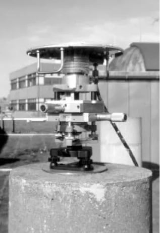
Another application of the proposed observable δSIDis feasible for the determination of small position changes. A baseline is observed on two different days. The linearisation, identical on both days for each station, is performed in the same manner as shown in equation (1). Using the reduced observable, i.e. the mean sidereal day time difference, one should yield the baseline components with a higher precision due to the improved phase measurement resolution. In an experiment for the verification of this approach a short baseline was observed on two different days. One of the antennas was mounted to a special mechanical sledge (figure 3) which allows shifts in two horizontal directions normal to each other. These can be performed with high precision (better than 0.1 mm). The observations on the first day were carried out without changing the position of the sledge. Small position changes at a rate of 2 mm were applied during the second day. The sledge was shifted every 10 minutes, first to the north and then to the east. This procedure was repeated several times. The dashed lines in figure 4 and 5 show the performed shifts.
Fig. 3: Sledge
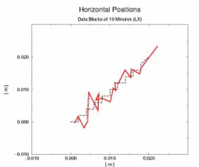
Figure 4 shows the displacements computed from the observations of the second day only. The positions were estimated with a simultaneous adjustment of L1 and L2, called LX. It is clearly visible that the agreement with the known shifts is rather poor. In figure 5 one can see the estimated positions after applying the mean sidereal day time difference with the GEONAP software module GNSDIF. The agreement between the computed displacements and the actual displacements is very good. Therefore the shifts of the sledge can easily be monitored by the mean siderial day time difference. The accuracy of the horizontal position estimation is in the order of 1.2 mm for an observation windows of 10 minutes only. Hence, with this method it is possible to monitor rather small deformations at the 1mm-level, even with very short observation times. Although observations on two days with an identical setup (mount, antenna etc.) are required, a number of applications are conceivable (e.g. dam monitoring).
CONCLUSIONS
Multipath is still the most limiting factor for precise positioning. With the proposed approach, the mean siderial day time difference, it is possible to eliminate multipath from the GPS observables. This derived observable can be used to observe small position changes from one day to another or estimate absolute PCV of an antenna.
The main advantages of the absolute antenna calibration are that it is a field procedure, free of multipath, and independent from a reference antenna's phase pattern. Through the rotations and tilts of the antenna areas without any observations are avoided, i.e. northern hole or low elevations, and the antenna is completely covered. Still, further examinations are requisite, e.g. errors introduced by the mount (errors in the rotation), influence of the
Fig. 4: True positions (dashed line) versus estimated positions (solid line) without δSID
.
mount on the multipath environment, and comparison with other sources by applying the PCV in operational GPS evaluations. A future goal is the automatic calibration with a very precise robot to avoid instrumental erros of the mount and save observation time.
The first experiments with the mechanical sledge for the determination of small deformations are already promising. The resolution of the positioning is clearly improved. Further experiments have to be carried out in order to improve this method for different applications, e.g. deformation monitoring in permanent GPS arrays.
Acknowledgment: Parts of this work are funded by the German Bundesministerium für Bildung, Wissenschaft, Forschung und Technologie (BMBF, No. 03PL022B).
REFERENCES
1. Schupler, B.R., T.A. Clark, R.L. Allshouse: Characterizations of GPS User Antennas:
Reanalysis and New Results, In: Beutler, G. et al. (Eds.). GPS Trends in Precise
Terrestrial, Airborne, and Spaceborne Applications. IAG Symposium, No. 113, Boulder, Colorado, USA, 1995.
2. Rothacher, M., S. Schaer, L. Mervart, G. Beutler: Determination of Antenna Phase
Center Variations Using GPS Data, Workshop Proceedings, IGS Workshop Special
Topics And New Directions, May 15-18, Potsdam, Germany, 1995.
3. Wübbena, G., F. Menge, M. Schmitz, G. Seeber, C. Völksen: A New Approach for
Field Calibration of Absolute Antenna Phase Center Variations, Proceedings of ION
GPS-96, 9th International Technical Meeting, September 10-17, Kansas City, Missouri, USA, 1996.
4. Bock, Y.: Continuous Monitoring of Crustal Deformation, GPS World, June 1991, pp. 40-47, 1991.
5. Genrich, J.F.,Y. Bock: Rapid Resolution of Crustal Motion at Short Ranges With the
Global Positioning System, Journal of Geophysical Research, Vo. 97, No. B3, pp.
3261-3269, 1992.
6. Wübbena, G.: The GPS Adjustment Software Package -GEONAP- Concepts and
Models, Proceedings of the Fifth International Symposium on Satellite Positioning, Las
![Fig. 2: L1-PCV [mm], a) Ashtech 700228 Rev. B, b) Trimble 4000 ST L1/2 Geod, c) Trimble Dorne Margolin Choke Ring.](https://thumb-us.123doks.com/thumbv2/123dok_us/1821924.2762984/4.892.265.622.114.343/ashtech-trimble-geod-trimble-dorne-margolin-choke-ring.webp)