This is a repository copy of Open access, open source and cloud computing: a glimpse into the future of GIS.
White Rose Research Online URL for this paper: http://eprints.whiterose.ac.uk/136095/
Version: Accepted Version
Book Section:
Pettit, C, Stimson, B, Barton, J et al. (4 more authors) (2020) Open access, open source and cloud computing: a glimpse into the future of GIS. In: Geertman, S and Stillwell, J, (eds.) Handbook of Planning Support Science. Edward Elgar Publishing , Cheltenham , UK , pp. 56-71. ISBN 9781788971072
https://doi.org/10.4337/9781788971089.00011
© Stan Geertman and John Stillwell 2020. This is a draft chapter. The final version is available in Handbook of Planning Support Science edited by Stan Geertman and John Stillwell, published in 20xx, Edward Elgar Publishing Ltd
https://doi.org/10.4337/9781788971089
[email protected] https://eprints.whiterose.ac.uk/ Reuse
Items deposited in White Rose Research Online are protected by copyright, with all rights reserved unless indicated otherwise. They may be downloaded and/or printed for private study, or other acts as permitted by national copyright laws. The publisher or other rights holders may allow further reproduction and re-use of the full text version. This is indicated by the licence information on the White Rose Research Online record for the item.
Takedown
If you consider content in White Rose Research Online to be in breach of UK law, please notify us by
CHAPTER 6
Open access, open source and cloud computing: a
glimpse into the future of GIS
Chris Pettit, Bob Stimson, Jack Barton, Xavier Goldie, Philip Greenwood, Robin Lovelace, Serryn Eagle-son
Author Details
Chris Pettit
Professor of Urban Science University of New South Wales
Built Environment, Red Centre West Wing UNSW Sydney NSW 2052, Australia [email protected] ORCID: 0000-0002-1328-9830 Bob Stimson E P G S P T U Q S E E S , Steele Building The University of Queensland
St Lucia QLD 4072, Australia [email protected]
ORCID: Jack Barton
Outreach Manager, G R I D
University of New South Wales
Built Environment, Red Centre West Wing UNSW Sydney NSW 2052, Australia [email protected]
ORCID: 0000-0002-4483-5179
Xavier Goldie Outreach Manager
Australian Urban Research Infrastructure Network (AURIN)
L T C B
The University of Melbourne VIC , Australia [email protected]
ORCID: 0000-0002-2362-2457
S S D
Australian Urban Research Infrastructure Network (AURIN)
L T C B
The University of Melbourne VIC 3010, Australia [email protected]
ORCID:
Robin Lovelace
University Academic Fellow - Transport and Big Data University of Leeds Faculty of Environment L LS JT UK [email protected] ORCID: 0000-0001-5679-6536 Serryn Eagleson Deputy Director
Australian Urban Research Infrastructure Network (AURIN)
L T C B
The University of Melbourne VIC , Australia [email protected]
ORCID: 0000-0001-9696-6886
List of Figures
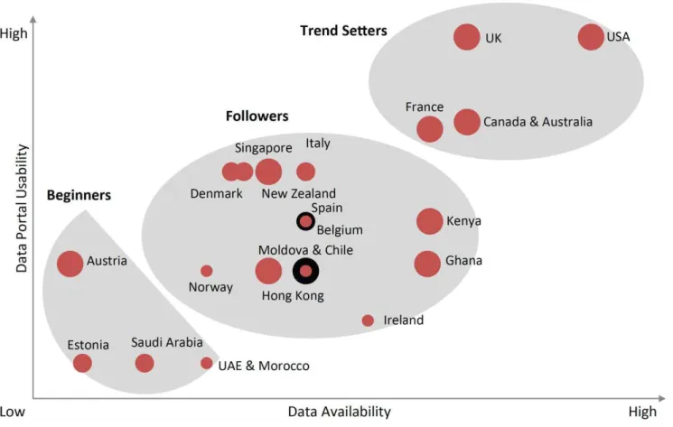
Figure 6.1: Analysis of open data initiatives in 23 countries (2012) in both availability (‘positioning’) and usability (‘pace of adoption’), with bubble size representing level of governmental support (Source: Capgemini Consulting 2013)
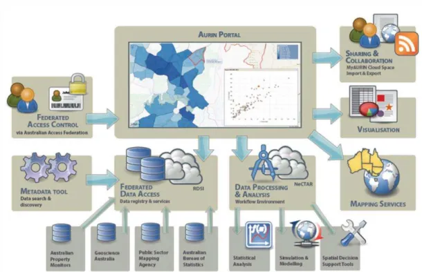
Figure 6.2: AURIN System Architecture for Workbench (Adapted from: Sinnott et al. 2014; Pettit et al. 2015)
Abstract
Open access data, open source software and cloud computing are three parallel and mutually reinforcing drivers of change in the field of applied Geographical Information Systems (GIS). While these developments create many new opportunities for GIS users and companies, they are also associated with under-explored risks. This chapter investigates ‘cloud GIS’, focusing on the Australian Urban Research Infrastructure Network (AURIN), an online, cloud-based data portal and GIS designed explicitly for Australian urban research and public-sector planning applications. AURIN provides direct access to datasets (4,000+), spatial analysis tools (100+) and powerful computational resources that are typically available in desktop GIS. The experience of developing, communicating and using AURIN has provided insight into the great opportunities unleashed by new models of GIS research. This chapter explores the opportunities, such as greater accessibility, transparency and consistency in decision-support for public policy, and risks of ‘cloud GIS’ and its potential uses for social benefit.
Keywords
Open access, open source and cloud computing: a
glimpse into the future of GIS
1 Introduction
The future of GIS is changing in ways that could barely be imagined only a few decades ago. We argue that these changes – which revolve around open access data (which we define to be: findable, openly licenced, able to be readily accessed and high-quality), coupled with open source software and cloud computing – constitute a paradigm shift in the way GIS work is undertaken. It is the aim of the chapter to explore the features of the new paradigm and provide insights that enable the GIS community to harness them, to tackle pressing societal problems of the 21st Century.
With technological change and intellectual advance, there are usually pioneering 'early adopters' and risk averse 'laggards' (Campbell et al. 2012, p.1322). The field of GIS is no exception. Provided their experience is well-documented and communicated (Haines & Jones 1994), early adopters also provide a glimpse into the future, allowing the community to make informed decisions about the best course of action. Many GIS users will continue using 'legacy' GIS regardless of new developments, but more often, the choices in GIS are about
when, how and why adapt than whether to change. Insight from early adopters of the 'new
paradigm' can help answer these questions.
The authors' experience of designing, developing, using and disseminating cloud-based GIS - the Australian Urban Research Infrastructure Network (AURIN) - provides a unique
opportunity to consider the implications of change on the GIS industry. The insights apply to GIS in general and the specific usage case of national institutions tasked with providing critical evidence to planners and other public sector decision makers.
2 Visions of GIS: future and past
Strategic plans depend on visions of the future. This can be seen in GIS-related fields including quantitative geography (Longley 2000), applied planning (Drummond & French 2008) and retail location analysis (Birkin et al. 1996). If the future turns out to be different from expectations, organisations holding these false expectations may be 'overthrown' by 'new entrants' (Tripsas 1997, p.342). In GIS, visions of the future can help plan effective teaching programs, applied projects and research initiatives. Moreover, strategic plans which account for future uncertainty tend to be more resilient or 'anti-fragile' than plans that do not (Taleb 2012). For this reason there has been much contemplation about the future of GIS.
Three of the most important developments driving current change in GIS are:
• Open access data: high-quality data provided on an open licence: the global
phenomenon of governments, the third sector and some private companies providing datasets aligned with the FAIR (Findable, Accessible, Interoperable, Reusable) data framework. That is, the data is shared in a way that will enable maximum use and reuse for public, industry and academic use.
• Open source software: the decentralized and self-organising movement and
intellectual property licensing paradigm that has allowed advanced GIS packages to be accessed free of charge, empowering millions of people worldwide, reducing the
financial costs of GIS and challenging incumbent monopolies.
• Cloud computing: in some ways the antithesis of the open-source software
development, this involves the centralisation of GIS activity onto remote 'server farms' providing an interface to users through a web portal.
None of these interrelated processes can be fully understood without reference to the ongoing and accelerating 'digital revolution' sweeping through an increasingly interconnected yet atomized global society (Rushkoff 2010). Each trend is also linked to the increasing size, complexity and dynamism of available datasets often labelled by the umbrella of 'big data' (Kitchin 2013; Boyd & Crawford 2012).
Pre-empting this 'big data' paradigm 15 years ago, Goodchild and Longley (1999, p.579) forecast that the ‘relative importance of conventional, governmental data providers is set to diminish’. Whether the importance of official datasets will or should diminish is open to debate (Bollier & Firestone 2010), and the ‘big data’ bandwagon certainly has its critics (Taleb 2013). In any case GIS is well-placed to adapt to the demands of large datasets (Crampton et al. 2013) and can even help reduce the size of enormous datasets via geographical aggregation. In the era of 'big data', quality control, cross-validation and scalability become critical to a project's success (Lovelace et al. 2016). The promise of cloud-based GIS is that each of these features can be provided to users without the need for advanced technological skill. This is also one of the central aims of AURIN, making it an ideal case-study to explore possible GIS futures.
Others have envisioned futures in which GIS tackles poverty, hunger, social inequality and environmental issues (Longley et al. 2005; Campagna 2005). To enable such dreams to become reality, technological and practical steps have been taken to make GIS more
participatory (Carver 2003; Simão et al. 2009; Elwood 2008), open (Byrne et al. 2013) and
collaborative (Pettit 2005). In a recent synthesis of participatory GIS software, Brown & Kyttä
(2014) outlined how the range of options for engaging the public in spatial planning has grown following increased access to data, software and online portals. The implementation of the ‘softGIS’ paradigm (Rantanen & Kahila 2008), for example, has been boosted by custom-made online portals. Online tools, if implemented in ways that are engaging and localized, ‘provide the foundation for smaller-scale, interpersonal engagement and discourse in the planning process’ (Brown & Kyttä 2014, p. 134). Such a direction offers diverse and optimistic alternatives to more centralized visions of cloud computing futures (Mansfield-Devine 2008). However, it appears that each of these visions was created assuming continued dominance of the desktop-based GIS paradigm. The revolutionary potential of cloud computing, open
source software and accessible datasets has yet to be assessed based on practical
experience of implementing a large-scale cloud-based GIS system, and therefore this chapter can contribute to a new vision for the future of GIS.
3 Drivers of change
In this section we focus on three of the most important drivers of change disrupting GIS (open access data, open source software and cloud computing) and how they relate to the AURIN project and GIS overall.
Open access data
A simple definition of open data is that which is available to the public free of charge (see Kitchin 2014, chapter 3, for more detailed definitions). With the advent of the 'data.gov' open data movement around 2008, there has been a significant global effort to make government data openly available (Figure 6.1). In GIS, this has been driven by support for public
engagement, urban research and spatial planning (Delaney & Pettit 2014).
Figure 6.1: Analysis of open data initiatives in 23 countries (2012) in both availability (‘positioning’) and usability (‘pace of adoption’), with bubble size representing level of governmental support (Source: Capgemini Consulting 2013)
However, change is not driven simply by data availability; data must also be usable (as communicated in Figure 6.1). We therefore use the term open access data to describe data that is findable, openly licenced, able to be readily accessed and high-quality. Although it is difficult to quantify the increase in the number of datasets available under open data licences, there has clearly been a proliferation in the open data licensing options that accompany
proliferation of open access data sources. The UK's Open Government Licence (OGL)ii, Open Street Map's Open Database License (OdbL)iii and the Australian Government's Open Access and Licensing Framework (AusGOAL)iv provide a few recent examples.
Motivations for opening-up datasets to public scrutiny may seem straightforward. The
'evidence-based policy' agenda demands that information be available to the public as soon as it 'can' be; it has advantages for transparency and the democratisation of decision making. In the US, for example, 40% of adults were found to search for government data online, indicating high latent demand for open data (Ding et al. 2011). Yet open data is often less neutral than it seems. Bates (2012), for example, explains how the UK government only adopted an open data strategy after it was lobbied for by industry. The same paper also challenges the assumption that open data is empowering to disadvantaged groups. ‘The social background of core OGD advocates tends to be elite: highly, often elitely, educated white men from the higher social classes’ (Bates 2012, p.2). One could argue, for example, that the increasingly popular GeoJSON file-type is a format for the 1%: the relatively small group of people who understand such files and how to visualize them (e.g. via code sharing website GitHub). This barrier to 'data understanding' is perhaps greater than the barrier of data access. Simply placing datasets online in proprietary formats does not necessarily equate to public empowerment.
These insights suggest that data disseminators need to not only serve data raw, but also explain how these files can be used and interpreted – in addition to installing, configuring and using proprietary or open source GIS software (discussed in the next section). Probably the most significant global effort to deal with the democratisation of geospatial data is the EU INSPIRE project, which provides templates, recommendations and tools for the dissemination of geospatial data and metadata (Bartha & Kocsis 2011; Trilles et al. 2017). This has also resulted in the INSPIRE Directive which legislates that all government funded geospatial data should be properly documented. The UK's Ordnance Survey also represents good practice in this area, providing information about file formats and software available from their website, in addition to a QGIS 'style file' for improving the display of their data on open source softwarev.
Open source software
There has been a gradual shift over the last decade from proprietary GIS software to the use of Open Source Geospatial technologies. This is not just a technological shift. There is a growing community building around the new code and software products captured by the term 'Free and Open Source Software for Geo' (FOSS4G), which is also the name of global,
regional and national conferences on the subject. FOSS4G products include desktop applications (e.g. QGIS, GRASS and gvSIG), low-level 'workhorse' GIS libraries (e.g. Geotools, GDAL and geos) and map servers (e.g. MapServer and Geoserver) amongst a plethora of other diverse tools. Some of these are highly innovative.
The Open Source Geospatial Foundation (OSGeo) supports the collaborative development of such open geospatial technologies and promotes their widespread use, especially for
worldwide education. There are a number of benefits that open source software provides, as summarized in a United States Military paper (Scott et al. 2011), including (i) increased agility and flexibility, (ii) faster delivery, (iii) increased innovation, (iv) reduced risk, (v) information assurance and security, and (vi) lower cost.
The commercial GIS market is still dominated by standalone applications designed primarily for use on a desktop computer. The implicit assumption in the majority of GIS research, methodological design and software development has been that this will continue. Yet many
FOSS4G products are becoming increasingly mature and feature-rich, in some cases surpassing the capabilities of proprietary GIS. These trends look set to transform the GIS landscape, yet little research has explored how these changes may unfold, let alone in the context of the trend towards cloud computing.
Cloud computing
During the digital revolution there have been three broad approaches to computing, from chronological to evolutionary: (1) centralized mainframe model; (2) desktop computing; (3) cloud computing. In the former, GIS was an expert-led, centralized activity – and in desktop computing it became more accessible to those who owned computers, provided they were trained in its use.
Cloud computing encapsulates the tendency of more and more computational work to be done on remote servers. Under this model, users can usually control the operations being undertaken on their PCs, but the 'heavy lifting' and 'mission critical' work is increasingly undertaken at distance, often by locating the GIS software on vast ‘server farms’. Therefore, an internet connection is needed to perform GIS work.
An excellent review of cloud approaches for geospatial data and analysis is provided by Evangelidis et al. (2014). As outlined in this chapter and elsewhere, the advantages of the cloud computing model over the mainframe and PC models are as follows:vi
Reduced IT costs: Specialist expertise, direct costs and capital expenditure can be offset to the provider
Scalability: Users can easily upscale or downscale their cloud usage according to business needs
Business continuity: Vulnerability to data loss is reduced with off-site distribution in the cloud
Collaboration efficiency: Secure access to common files regardless of the user’s location
Flexibility of work practices: One user working in multiple locations has consistent access to repositories
Access to automatic updates: Users transparently benefit from cloud-side software updates and hardware upgrades
With broadband internet being rolled out at an accelerating rate worldwide, increasingly geographically dispersed working patterns and international collaboration, the attractions of cloud-based solutions become clearer still. Yet ‘the current generation of GIS software lacks accessibility; there is no easy way for the simple sharing of data and projects with a person at the desk next to you, not to mention [over] larger distances’.vii
4 AURIN: a fully featured cloud GIS
Some research centres have responded in real-time to the emerging pressures outlined thus far, and AURIN is one such example, becoming an 'early adopter' in the GIS industry. For a greater sense of the cloud-based GIS space, we first review select state-of-the-art
alternatives.
Alternative cloud-based GIS tools
The National Renewable Energy Laboratory (NREL) in the USA has created the Secure Transportation Data Center.viii This online portal provides access to a large store of travel data from across the USA including (given appropriate permissions) individual-level travel data and second-by-second acceleration history (Neubauer & Wood 2013). It includes processing capabilities 'in the cloud' using a variety software packages such as QGIS and R.
INSPIRE is a large European Union project which seeks to unify spatial information under a coherent schema and which includes provision and visualisation of the data (Baranski et al. 2011). The desire to make the data available and of use to society has resulted in a number of efforts towards cloud-based GIS, including a system for 3D visualisation of Greek water resources (Kallergis et al. 2014).
Perhaps most ambitious of all, the CyberGIS Center is working on a number of portals and online applications for researchers and the public. At the moment of writing (September 2018) the Gateway was hosting twelve Apps including CGPySal for spatial regression in the cloud and Flumapper, for online analysis of social media data.ix
Amongst these projects, AURIN stands out as the most advanced in terms of features, data provision and real-world applicationsx - predominantly to public-sector and academic
researchers. But what makes AURIN uniquely placed to shed new insight into the future of GIS?
What is AURIN?
AURIN (www.aurin.org.au) is a web-based virtual environment (e-Infrastructure) offering secure access to diverse, distributed and heterogeneous data sets. AURIN combines data from many different agencies and provides both analytical and visualisation tools to
interrogate these data.
The primary aim is to support a range of urban researchers and planners to access, visualize and analyse official datasets for evidence-based research and policy development. Reflecting this 'target audience', the two main functions underlying AURIN's technical design are (1) data access and (2) a suite of tools for interacting with the data.
There are three main features of the AURIN infrastructure: (1) AURIN Portal - a web portal complete with access to data and analytical tools; (2) AURIN Map - a map for the visualisation of research output data; and (3) AURIN Open API - an API for direct data access to data with
an open licence.
The main features of the AURIN Portal (data access part of the web portal) are:
Access to heterogeneous datasets from multiple sources and data owners, integrated by a common format (GeoJSON) and typically aggregated via a standard set of geographical boundaries.
Single sign-on for anyone with an Australian academic email, via the Australian Access Federation (AAF), and restricted data sources upon application. Before AURIN, access would often need to be arranged on a per dataset basis.
User-friendly data browsing, search, filtering and query by geographic region.
AURIN's suite of tools enable data manipulation, visualisation and analysis in the cloud. The aim is to ensure that the data is not only available but useful. These tools have been integral to AURIN's design and deployment, enabled by:
A suite of specialist spatial data analysis tools that are not widely available. A select group of statistical analysis tools that are the staple of any analysis and
modelling.
A comprehensive set of data manipulation tools to facilitate the use of the above analytical tools.
Dynamic web-map with a choice of backdrops, including satellite imagery, Open Street Mapxi and stylized maps provided by Stamen.xii
User-friendly data browsing, search, filtering and query by geographic region.
Different visualisation tools, including a choropleth map with the web portal, and a full suite of all well-known graphical tools.
An overview of the AURIN system is provided in Figure 6.2. Readers interested in the technical aspects of AURIN are directed towards Sinnott et al. (2014).
Figure 6.2: AURIN System Architecture for Workbench (Adapted from: Sinnott et al. 2014; Pettit et al. 2015)
Data hosting
Critical to AURIN is the provision of data. It is a federated data architecture, meaning that data is requested from the original source when it is required. The reasons for this distributed structure are as follows:
AURIN developers do not need to understand all the datasets if they are hosted externally.
Computing resources can be allocated more towards the visualisation and analysis of data rather than data hosting.
Changes in datasets will be automatically updated by the data provider. However, where historical data is required, AURIN has a connection to the Australian Data Archive (ADA) as well as a local repository to save snap shots of the data over time – which assists in temporal analysis capability and saves records of data before they are over-written.
Both users and providers harness the benefits of cloud computing.
AURIN is built on open source software, avoiding the licensing issues associated with
propriety software, and has cloud-based access, creating the potential for national economies of scale. A series of data hubs have been established across the country to connect federated repositories with end users. This federated architecture allows data providers to maintain control over how much data is accessed and retain the right to 'turn-off' the supply of data at
any moment. It also allows cautious providers to provide access to progressively larger datasets over time, to their discretion.
Urban data, in its unit-level, granular form can contain spatial identifiers including secure information such as names, addresses, or building contents. Surveyed data can be expensive to collect and maintain – especially when costed with quality control, geographic coverage and the frequency of time-series surveys. This not only represents an investment from the data custodian in their own data assets, but an opportunity to share de-identified, aggregated data with the research community plus letting the custodian provide graduated, merit-based access to authorized users.
As such, AURIN is freely available across Australia for any member of the academic/research community with a university affiliation. A user logs in through their respective institution’s Identity Provider (IdP) attached to their standard ‘edu.au’ email address. Further to this, the public/government sector may log in with an account on a Virtual Home Organisation (VHO). As there is no IdP spanning the entire Australian government, these accounts are set up upon application. Currently, some 800 users in the government sector are using AURIN, and every member of the Australian academic community has access to AURIN. Up to date user
statistics are published at https://userstats.aurin.org.au/.
Data analysis in the cloud
A number of tools are provided within AURIN to users. To ensure robust capabilities during this data processing stage, R was chosen as back-end for processing and analysis. This allowed domain experts in the field of spatial statistics, such as researchers based at CofFEE, to provide spatial statistical tools in reproducible code. CofFEE researchers were employed directly to implement a full suite of spatial statistical data analysis tools, customize functional zones, widen the number of levels of data access, and demonstrate and test AURIN's data analysis capabilities.
User testing and engagement
Longitudinal user testing has measurably improved user experience and technical delivery during the beta phases of AURIN development (Pettit et al. 2014). Structured feedback has been gathered, via surveys, during:
unguided, online testing as part of a monitoring and evaluation survey semi-guided, laboratory-based user testing sessions, and
guided tutorials, workshops, and masterclasses.
Upon collation and analysis, common user issues were identified, prioritized and then re-integrated into the subsequent beta phase of the agile development process.
When designing map-based systems, navigation cues rely heavily on graphic elements, and subtle changes to these can have measurable effects on system usability. Ease-of-use is a
critical aspect of maximising uptake and has also been identified as a major barrier for acceptance of online portals (Vonk et al. 2005). An intuitive interface helps first-time users familiarize themselves with the system and also facilitates up-skilling for ‘non-expert’ users to interact with ‘expert’ users and directly manipulate data or research methods. This is
important not only within large organisations, but also the broader community. Community participation in spatial decision making plays a critical role in obtaining consensus amongst diverse groups of stakeholders (Brown & Kyttä 2014; Simão et al. 2009). To facilitate user collaboration the AURIN Portal has implemented the ability to share projects.
Practical Application in Teaching and Learning
User uptake is a critical measure of the success of AURIN as a resource for urban researchers. The open and web-based nature of the tool makes it ideal for supporting
university-level teaching and learning initiatives. During the beta phase many bugs were fixed, and feature requests added. As of the 31st August 2018, AURIN has a regular user
community of 3000+ students, and around 800 professional researchers. During the development phase and onward, AURIN is being deployed to labs of 20-80 students. The system is introduced through introductory exercises and documentation, allowing use for their own studies. This environment also provides an opportunity for load testing the concentration of concurrent users in a classroom. During these lab sessions, students tended to work at a similar pace, calling tools and functions at the same time. Behind the scenes, the developers monitored the system resources following use of AURIN by 80+ users.
An example of AURIN in teaching is ‘Urban Informatics’, a masters-level elective first run in mid-2014 and subsequently late-2015. The students were given a brief to interface with the Melbourne2030 plan, as published by the Metropolitan Planning Authority (MPA). This
presented the opportunity for students to directly engage with professionals from the MPA and conduct research with real-world application. An integral component of Melbourne2030 was the establishment of a series of ‘National Employment Clusters’ (NECs). This policy has been designed to balance Melbourne’s urban growth by offsetting the pressure on a
highly-centralized CBD with peri-urban developments, encouraging polycentric travel patterns. In small groups, students developed a report focussing on one of the NECs, as if they were delivering a professional report as consultants. This brief encouraged students to draw on the data available to them through AURIN to build a site-specific evidence-base communicated through graphics, including charts, photographs, maps and urban illustrations. Students also proposed a ‘blue-sky’ scenario to rapidly convey a speculative vision that the NEC might develop. This provided complemented quantitative analysis with experimental and aspirational proposals.
The topics selected by students included:
• Sourcing population, dwelling and land data from the Australian Bureau of Statistics • Sourcing employment by ANZSIC category
• Generating maps of land use, population density • Running the employment clustering tool
• Running the walkability tool
The latter tools process input datasets in the cloud-based services in the background. The cloud-based architecture provided access to the tools without specialized software installed locally. The concurrent use of AURIN's data provision and analysis capabilities, often involving mistakes and a process of trial and error from the students, put pressure on the system, providing a valuable test for system testing for future use in mission-critical applications.
Programmatic Access to Data and Tools
Following user testing and engagement, many users have requested access to data and tools, not only through AURIN's user interface, but via programmatic access. The next phase of AURIN's development will further open access to data and tools via a public application interface (AURIN Open API). This public API allows users to build their own applications, or to use existing clients such as QGIS or ArcGIS to access AURIN tools and data.
One important feature of AURIN is that it converts the multitude of data formats into an existing standard and exposes them via a Web Feature Service (WFS). Some data, while publicly accessible, are in formats that are not widely adopted and therefore are difficult to be ingested into other applications. Other datasets are not publicly available or easily obtainable. By using the AURIN Open API, these datasets can be ingested by client applications fluent in the WFS standard, and then used in much broader ways.
Similarly, tools can the made available as a service by the Web Processing Service (WPS) standard. Therefore, tools not available elsewhere, such as AURIN's spatial statistics tools, can be accessed by a wider audience for applications beyond their original presentation in the web portal; for example, as a custom mobile application. Clients already exist, such as QGIS, that can access tools exposed as a WPS (and use QGIS’s basic data manipulation tools alongside them). QGIS also contains a visual scripting environment. At the time of writing, this environment cannot yet connect to tools exposed via WPS, but this feature is likely to be adopted, following in the footsteps of early adopters such as ArcGIS.
5 Discussion
The three main drivers of change we discussed – open access data, open source software, and cloud computing – are all observed in AURIN and provide an example of how these capabilities can contribute to the evolution of GIS.
Our earlier observations commented on the need to go beyond data provision to explain how the files can be used and interpreted. AURIN provides visualisation and analysis tools,
accompanied by a user-friendly interface, to remove some of the barriers to open data usage. Its periodic user feedback provides a way to make incremental improvements over time. To manage the balance between open data access and security, AURIN allows data providers to define and adjust the levels of access themselves. In this way, trust is established between data providers and users, in addition to providing the AURIN team with valuable insights into
the best way to host robust and trustworthy data sets.
As development of AURIN continues, exposing tools as a WPS will allow other software products to access these and apply them innovatively; in addition, visual scripting could help train newer users and provide better validation for research results. Both of these additions will provide better integration with open source software, creating greater incentives for companies to move away from proprietary GIS.
Finally, the flexibility of cloud computing responds to the demands of a globalized world. AURIN’s multi-user student projects have created a way to test the efficiency of simultaneous access within AURIN. This signifies to software developers that cloud computing can be built to the same standards as desktop computing but offer reduced costs and streamlined
maintenance along the way.
The experience of working with AURIN provides insight into the future of GIS that, we argue, goes beyond theoretically or historically based speculation. Because AURIN is already being used in mission-critical real-world applications with policy impact, for instance in addressing affordability and biodiversityxiii, it provides more insight into the 'near-market' of GIS evolution, rather than 'blue sky' thinking. It has also inspired subsequent research, for instance, the Propensity to Cycle Tool, an online mapping tool to prioritize cycling investment (Lovelace et al. 2017). This project demonstrates the importance of such tools for informing policy: it is now a key part of the legally binding responsibility of English Local Authorities to create Local Cycling and Walking Plans. The tool is much simpler than AURIN and raises the question of where priorities should lie between creating many small, modular mapping sites aimed at addressing specific policy questions and the clearly-documented benefits of a one-stop shop.
6 Conclusion
Should international organisations such as the UN invest in a ‘global AURIN’? While the answer to that question remains unclear, we can advise that the public sector adapt to
changes in the GIS market rather than resist change. The AURIN infrastructure is connecting communities of researchers and decision-makers nationally, enabling fast-tracked access to urban data, greater transparency and consistency in decision-support for public policy. ‘Cloud GIS’, equipped with easy-to-use visualisation tools, allows for open data to be interpreted by both new users and experts. Removing barriers to entry in the use of could computing helps address the concern that open data will exacerbate inequality (Bates 2012) – by empowering the public sector to use its capabilities to address societal issues with
evidence-based analyses, bringing closer a future where GIS is used to address poverty, hunger, environment and inequality (Longley et al. 2005; Campagna 2005). The clear benefits of online geographic data portals such as AURIN suggest they are highly worthwhile and are only set to grow world-wide, with major implications for the future of GIS.
References
Baranski, B., Foerster, T., Schäffer, B. and K. Lange (2011), ‘Matching INSPIRE Quality of Service Requirements with Hybrid Clouds’, Transactions in GIS, 15 (s1), 125–142. Bartha, G. and S. Kocsis (2011), ‘Standardization of Geographic Data: the European
INSPIRE directive’, European Journal of Geography, 2 (2), 79–89.
Bates, J. (2012), ‘ “This is what modern deregulation looks like”: co-optation and contestation in the shaping of the UK’s Open Government Data Initiative’, The Journal of Community
Informatics, 8 (2), 1–7.
Birkin, M., Clarke, G., Clarke, M.P. and A.G. Wilson (1996), Intelligent GIS: location decisions
and strategic planning, London, UK: Geoinformation Group.
Bollier, D. and C.M. Firestone (2010), The promise and peril of big data, Washington, DC, USA: Aspen Institute, Communications and Society Program.
Boyd, D. and K. Crawford (2012), ‘Critical Questions for Big Data’, Information,
Communication & Society, 15 (5), 662–679.
Brown, G. and M. Kyttä, M. (2014), ‘Key issues and research priorities for public participation GIS (PPGIS): A synthesis based on empirical research’, Applied Geography, 46, 126– 136.
Byrne, J.M., Lindsay, J. and A.A. Berg (2013), ‘Open Source GIS based integrated watershed management,’ abstract H11K-04 presented at 2013, Fall Meeting, American Geophysical Union, San Francisco, CA, 9-13 December.
Campagna, M. (2005), GIS for sustainable development, Boca Raton, FL, USA: CRC Press. Campbell, A.R., Ryley, T. and R. Thring (2012), ‘Identifying the early adopters of alternative
fuel vehicles: A case study of Birmingham, United Kingdom’, Transportation Research
Part A: Policy and Practice, 46 (8), 1318–1327.
Capgemini Consulting (2013), The Open Data Economy Unlocking Economic Value by
Opening Government and Public Data, accessed 6 September 2018 at
https://www.capgemini.com/resources/the-open-data-economy-unlocking-economic-value-by-opening-government-and-public-data/
Carver, S. (2003), The future of participatory approaches using geographic information: Developing a research agenda for the 21st century’, URISA Journal, 15 (1), 61–71. Crampton, J.W., Graham, M., Poorthuis, A., Shelton, T., Stephens, M., Wilson, M.W. and M.
Zook (2013), ‘Beyond the geotag: situating “big data” and leveraging the potential of the geoweb’, SSRN Electronic Journal, 40 (2), 1–29.
Delaney, P. and C. Pettit (2014), ‘Urban Data Hubs Supporting Smart Cities’, paper presented at Research@Locate ’14, Canberra, Australia, 7-9 April.
Ding, Lebo, T., Erickson, J.S., DiFranzo, D., Williams, G.T., Li, X., Michaelis, J., Graves, A., Zheng, J.G., Shangguan, Z., Flores, J., McGuinness, D.L. and J.A. Hendler (2011), ‘TWC LOGD: A portal for linked open government data ecosystems’, Web Semantics:
Science, Services and Agents on the World Wide Web, 9 (3), 325–333.
Drummond, W.J. and S.P. French (2008), ‘The future of GIS in planning: Converging
technologies and diverging interests’, Journal of the American Planning Association, 74 (2), 161–174.
Elwood, S. (2008), ‘Volunteered geographic information: future research directions motivated by critical, participatory, and feminist GIS,’ GeoJournal, 72 (3-4), 173–183.
Evangelidis, K., Ntouros, K., Makridis, S. and C. Papatheodorou (2014), ‘Geospatial services in the Cloud’, Computers and Geosciences, 63 (2011), 116–122.
Goodchild, M.F. and P.A. Longley (1999), ‘The future of GIS and spatial analysis’, in P.A. Longley, M.F. Goodchild, D.J. Maguire and D.W. Rhind (eds), Geographical Information
Systems: Principles, Techniques, Applications and Management, New York: Wiley, pp.
567–580.
Haines, A. and R. Jones (1994), ‘Implementing findings of research’, BMJ: British Medical
Journal, 308 (6942), 1488.
Kallergis, D. Papacharalampou, C., Chimos, K., Chavakis, T. and C. Douligeris (2014), ‘A Hybrid Cloud Computing Approach for Managing Spatial Data: A Case Study for Water Resources in Greece’, paper presented at Computing for Geospatial Research and Application (COM. Geo) Fifth International Conference, Washington, DC, 4–6 August. Kitchin, R. (2013), ‘Big data and human geography: Opportunities, challenges and risks’,
Dialogues in Human Geography, 3 (3), 262–267.
Kitchin, R. (2014), ‘The data revolution: Big data, open data, data infrastructures and their
consequences’, Thousand Oaks, CA, USA: Sage.
Longley, P., Goodchild, M., Maguire, D.J. and D.W. Rhind (2005), Geographic information
systems and science, 2nd Edition, USA: John Wiley & Sons.
Longley, P.A. (2000), ‘The academic success of GIS in geography: Problems and prospects’,
Journal of Geographical Systems, 2 (1), 37–42.
Lovelace, R., Cross, P., Clarke, M. and M. Birkin (2016), ‘From Big Noise to Big Data: towards the verification of large datasets for understanding regional retail flows’, Geographical
Analysis, 48, 59–81.
Propensity to Cycle Tool: An open source online system for sustainable transport planning’, Journal of Transport and Land Use, 10 (1), 505–528.
Mansfield-Devine, S. (2008), ‘Danger in the clouds’, Network Security, 2008 (12), 9–11. Neubauer, J.S. and E. Wood (2013) ‘Accounting for the Variation of Driver Aggression in the
Simulation of Conventional and Advanced Vehicles’, paper presented at the SAE 2013 World Congress & Exhibition, Detroit, MI, 16–18 April.
Ordnance Survey (2018), OS VectorMap Local, accessed 6 September 2018 at
https://www.ordnancesurvey.co.uk/business-and-government/products/vectormap-local.html
Pettit, C., Barton, J., Goldie, X., Sinnott, R., Stimson, R. and T. Kvan (2015) ‘The Australian urban intelligence network supporting smart cities’, in S. Geertman, J.J. Ferreira, R. Goodspeed and J. Stillwell (eds), Planning support systems and smart cities,
Switzerland: Springer International Publishing, pp.243–259.
Pettit, C., Glackin, S., Trubka, R., Ngo, T., Lade, O., Newton, P. and P. Newman (2014), ‘A co-design prototyping approach for building a precinct planning tool’, in S. Li and S.
Dragicevic (eds), Joint International Conference on Geospatial Theory, Processing,
Modelling and Applications, Toronto, Canada, pp. 47–53.
Pettit, C. (2005), ‘Use of a collaborative GIS-based planning-support system to assist in formulating a sustainable-development scenario for Hervey Bay, Australia’, Environment
and Planning B: Planning and Design, 32 (4), 523–545.
Rantanen, H. and M. Kahila (2008), ‘The SoftGIS approach to local knowledge’, Journal of
Environmental Management, 90, 1981–1990.
Rushkoff, D. (2010), Program or Be Programmed: Ten Commands for a Digital Age, New York: OR Books.
Scott, J., Wheeler, D.A., Lucas, M. and J.C. Herz (2011), Open Technology Development
(OTD): Lessons Learned and Best Practices for Military Software, government report,
U.S. Department of Defence.
Simão, A., Densham, P.J. and M. Haklay (2009), Web-based GIS for collaborative planning and public participation: An application to the strategic planning of wind farm sites’,
Journal of Environmental Management, 90, 2027–2040.
Sinnott, R.O., Bayliss, C., Bromage, A., Galang, G., Grazioli, G., Greenwood, P., Macauley, G., Mannix, D., Morandini, L., Nino-Ruiz, M., Pettit, C., Tomko, M., Sarwar, M., Stimson, R., Voorsluys, W. and I. Widjaja (2014), ‘The Australia urban research gateway’,
Concurrency and Computation: Practice and Experience, 27 (2), 358–375.
Taleb, N.N. (2013), ‘Beware the Big Errors of “Big Data”’, accessed 12 September 2018 at http://www.wired.com/2013/02/big-data-means-big-errors-people.
Trilles, S., Díaz, L. and J. Huerta J. (2017), ‘Approach to Facilitating Geospatial Data and Metadata Publication Using a Standard Geoservice’, International Journal of
Geo-Information, 6, 126.
Tripsas, M. (1997), ‘Surviving radical technological change through dynamic capability:
Evidence from the typesetter industry’, Industrial and Corporate Change, 6 (2), 341–377. Vonk, G., Geertman, S. and P. Schot (2005), Bottlenecks blocking widespread usage of
planning support systems’, Environment and Planning A: Economy and Space, 37 (5), 909–924. iihttp://www.nationalarchives.gov.uk/doc/open-government-licence/version/3/ iiihttp://opendatacommons.org/licenses/odbl/ ivhttp://www.ausgoal.gov.au/the-ausgoal-licence-suite vhttp://www.ordnancesurvey.co.uk/resources/carto-design/cartographic-stylesheets.html vi See
https://www.business.qld.gov.au/business/running/technology-for-business/cloud-computing-business/cloud-computing-benefits (Last accessed 9/17/2018)
viiSee http://www.giscloud.com/blog/the-future-of-gis-lies-in-the-cloud/ viiiSee http://www.nrel.gov/vehiclesandfuels/secure_transportation_data.html ixSee http://sandbox.cigi.illinois.edu/home/
xSee https://aurin.org.au/case-studies/
xi See http://www.openstreetmap.org/ (Last accessed 9/1/2014) xii See http://stamen.com/ (Last accessed 9/1/2014)
xiiiSee https://aurin.org.au/case-studies/