ETH Value Lab: A framework for managing large-scale urban projects
Jan HALATSCH, Antje KUNZE, Remo BURKHARD, Gerhard SCHMITT(Chair for Information Architecture, ETH Zurich)
Abstract: In this paper we discuss how the planning of complex urban systems can be supported by combining (a) dynamic, complimentary visualization software toolkits for planning, project management and visualizing neighborhoods, (b) interactive real-built information architecture, (c) multi-touch, large format display devices and (d) collaboration techniques into a tool for modeling and designing future cities called Value Lab. Finally, we show comprehensive examples from research, application, and teaching.
Keywords: Urban planning management, multi-touch displays, information architecture, environmental simulation, city modeling
1
Introduction
1.1 Background and Motivation
Future Cities – as a synonym for today’s evolving mega-cities – can be interpreted as networks that encompass dynamic properties and attributes operating on different spatial scales with instant stimuli on dimensions like social, cultural and economic measures. Infrastructures and the environment have to be adapted in response to the fast and large growing rate in mega cities like Shanghai. New sustainable urban development strategies have to be elaborated. Especially on a long-term view the quality of life in mega cities has to be ensured. Planners, designers, officials and even the public are heavily stressed to understand, to plan, and to communicate the effects of persistent increasing demands regarding the use and the forms of energy or the consumption of natural resources as well as high expectations on transportation and communication infrastructure. Therefore, for large scale planning projects it is crucial to avoid missing links between experts and laymen. Because of the inherent complexity and its dynamic manner it is often very hard to perceive, to represent, and to communicate sophisticated problems or solutions since the matter covers an interdisciplinary challenge, where many different skills may be combined: Computer Science, Environmental Studies, Sociology, Design, Communication, Urban Planning, Strategic Management, Architecture, and Aesthetics, and even feedback from the general public.
The endeavor of this paper is to create a shared vision, to map the desires of the involved participants and to contribute the challenge of participatory planning processes with the help of the urban planning framework ETH Value Lab. In this paper we present the major milestones and technical achievements of the ETH Value Lab project.
1.2 Contributions
We group the main contributions of this presented framework into the following branches:
Environmental Simulation: A simulation and visualization software system for the creation of large urban environments, evaluation of occupant movement, and high quality real-time visualization of simulation results.
GIS-based Project Management: A GIS-layer oriented software for project management that is easy to use with touch gestures and works in large-scale multi-screen setups.
Display and Interaction Systems: A state-of-the-art large-scale multi-screen setup equipped with multi-touch technology that is connected to online and graphic computing resources that are situated outside the presentation room. At the same time all possible configuration data is brought to the user within a few fingertips.
Information Architecture: An architectural interior design that governs the processes and workflows within in a collaborative working setup and takes care of the usability of the display and interaction system.
1.3 Overview
This paper is organized as follows: Section 2 starts with an overview of available related work within each branch of the framework. Section 3 states the main concepts of our framework and in section 4 we present the associated implementation in more detail. In section 5, we show examples from real world scenarios and teaching. Section 6 outlines our conclusion and comprises future work.
2
Related Work
Related work is structured as follows in:
Environmental Simulation: We adapted the systems described by Aschwanden et al. [1], Halatsch et al. [2], Ulmer et al. [3], and Müller et al. [4] for the use in the ETH Value Lab. It seems to be promising to evaluate resulting geometry of shape grammar computations for urban environments [5] with crowd simulation methods [1]. For more details on the used shape grammar system please refer to [4]. For an extensive overview on crowd animation systems please refer to Magnenat-Thalmann [6].
Display and Interaction Systems: Display and Interaction Systems had been quite recently explored by Gross et al [7]. Examples of room-sized multi-projector displays such as six planar display walls include the CAVE™ and tiled display walls, such as the PowerWall are often limited in contrast ratios and daylight use. Multi-user experiences and direct-on-display surface interaction of the systems described above are quite unclear. We discard active and passive 3D screens and projection-based systems in favor of touch interfaces and to establish multi-user setups.
Information Architecture: The paradigms and ideas behind the term Information Architecture [8, 9] had strongly influenced the final design of the ETH Value Lab. For more information please refer to Burkhard [10], Halatsch and Kunze [11].
3
Methodologies for managing Future Cities
Future Cities, especially mega cities have to be understood as a dynamic system - a network that bridges different scales, such as local, regional, and global scales. Since such a network comprises several dimensions, for example social, cultural, and economic dimensions it is necessary to connect active research, project management and urban planning as well as communication with the public for example to establish a mutual vision, or to map the desires of the involved participants. In the following we present the main components of our framework. Further we will discuss uprising needs and possible solutions. Environmental Simulation: Although several software-based methods are available to simulate and evaluate certain aspects of urban environments, they a) are often limited in data exchange and project organization, b) require expert knowledge to operate and understand the software, c) lack in multi-user interaction that is needed for collaborative planning, d) offer only limited real-time exploration of simulation results for evaluation of a design. We like to answer that needs with an urban simulation and visualization system that is capable of importing standard CAD and 3D geometry via common exchange standards like Collada and Autodesk FBX. The platform can be run on large multi-screen environments and offers present information to large user groups such as in workshops. At the moment our system offers the visualization of large-scale urban environments and the simulation of occupant movement that can be evaluated in real-time.
GIS-based Project Management: Common software-based project management tools offer powerful methods to manage resources and durations. Since a typical urban planning project associates all processes with geographic information it is strictly necessary to keep that geographic information present at all planning and project management stages to establish a shareable vision between all stakeholders. This is a
gap that available project management tools cannot offer. Our solution brings GIS-information together with sketch-based touch-display interaction and is multi-user and multi-screen capable. Our GIS-based project management software keeps information present and interactive on up to five (5) large-scale high-resolution screens. That is necessary since typical board meetings in urban planning consist of up to fifteen stakeholders.
Display and Interaction Systems: A major milestone presents the accessibility both of our Environmental Simulation and our GIS-based Project Management system from one large-scale interactive display space. The explorable screen size and available human computer interaction methods of todays office and meeting rooms installation are focused to fulfill single user requirements. A multi-screen setup can drastically enhance collaboration and participatory processes by keeping information present to all attendees for example of an urban housing workshop. Therefore, we promote such a configuration and complete it with full multi-touch support for direct on screen interaction. The corresponding hardware has to be open to standard software while delivering full computing and graphics performance. The system has to be easy to operate for average skilled computer users.
Information Architecture: The authors developed the ETH Value Lab as a new example for collaboration and interaction in an architectural space. Special components such as large area multi-touch displays enhance collaboration no matter if users are present within the ETH Value Lab or are connected to it via network infrastructure from outside. An advanced architectural design is vital for a complete understanding of the workflows within such a special location. The authors analyzed the different states of operation on a hardware layer as well as on an abstracted layer that is visible to the users.
4
Technologies for the planning of large urban environments
In the following we like to promote the technologies embedded in our urban planning framework that consist of a) Environmental Simulation, b) GIS-based Project Management, c) Display and Interaction Systems and d) Information Architecture. They can be understood as a first starting point to guide and visualize long-term planning processes while intensifying the focus on the optimization of infrastructures (e.g., transportation, water, communication systems) and buildings through new concepts, new technologies and new social behaviors to cut down CO2 emissions, energy consumption, traffic load, and to increase the quality of life.
4.1 CityEngine and Massive software: Toolkits for environmental simulation
In this section we introduce two ongoing research projects in the branch of environmental simulation that contribute as design tools for the development of future cities in the ETH Value Lab.
This first project explores how shape grammars can be integrated into the urban design process. We extended a system called CityEngine [4] that now can be used to visualize master planning scenarios in high polygonal resolution. To this system we contributed the ability to describe urban design patterns in the form of hierarchical ones. This system can be applied (1) to the field of urban planning as well as to project development for the pre-visualization of large urban areas - especially in cases where common building regulations exist and (2) to evaluate simulation criteria on an urban scale e. g. in order to achieve lower CO2 emissions within cities (3) to the field of architectural history and archeology for the reconstruction of building designs and cities [12,4], (4) to the field of architectural theory e.g. for the analysis and synthetic construction of unbuilt city utopias, and (5) to the curriculum in education as a systematic learning tool to understand and encode architecture. This system had been initially introduced by Parish and Müller [13] for the production of city-like structures and computer generated architecture by Müller et al. [4]. We adapted this system into a novel framework for grammar-based planning of urban environments to use inside the ETH Value Lab. For more information on the use of shape grammar tools in urban planning we like to refer the reader to [2, 5].
Motion planning and path finding have been studied extensively, both for productions in game development, in film and broadcast productions, and has a strong background in robotic research and areas covering knowledge mining and artificial intelligence. We apply these insights with our second research
project with an implementation based on the Massive crowd animation software [18]. Our method aims to analyze synthetic architectural mid-scale urban models and inherent spatial configurations in a virtual environment with agents that represent typical occupants of the considered area. Important goals are a) to evaluate the functionality of local networks that can later on be used as representations of modeled urban objects. These distributed objects can be urban goals like train stations, pedestrian crossing, corner shops, office buildings, and courtyards with private zones) and b) the corresponding load that a investigated area will achieve. Standard 3D geometry serves as a design input that will be evaluated with adapted agents for urban simulation. The outcomes are a) specific visualization maps showing the movement, residence time, and the density of crowds in a certain area over time, b) 3d animations which can be easily explored in real-time, and c) animated footages for each agent and or agent groups.
4.2 Future City Designer: A GIS-based collaborative project management tool
In cooperative planning it is very challenging to establish a shared understanding among the involved partners. In this case, the coordinative functions of visual representations are a significant help. A static strategy map or roadmap for example can facilitate aligning all partners to one mutual “big picture”. While a static map designed by one author already offers support, the most valuable effects can be measured when a group designs the map in a moderated process. If a group of people develops a visual representation in collaboration, they will accept it and adhere to it more strongly. In contrast, if they are not actively involved, they will read it and most likely forget it, but certainly not enthusiastically share it with peers. Because the co-creation of a big picture is a proven way to gain a shared vision and mutual understanding and because no tool exists today we are currently implementing our own tool. The emphasis lies on the integration of GIS functionality along with project management tool behavior and simple user interaction paradigms like design sketching and image annotation as well as roadmap drafting. The working title is “Future City Designer” and is customized for the ETH Value Lab. The software allows to add background images of the planned area and to include individual elements on different layers. Such elements are: projects, reference images, texts, sketches, and project members as well as tasks.
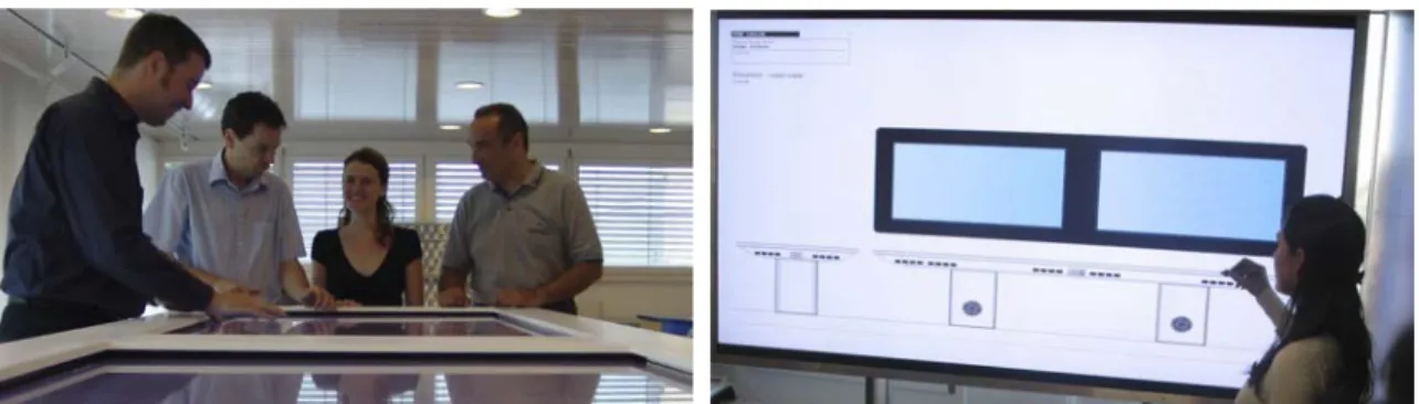
4.3 ETH Value Lab hardware: A platform for urban simulation and participatory planning
Figure 1. First experiments with touch table and touch board (right figure).
The ETH Value Lab (approximately 8 m in width, 10 m in length, 6 m in height) consists of one display table that is equipped with two (2) 65 inches LCD screens. Furthermore it offers a large interactive display board (see figure 1), which has implemented three (3) LCD-screens where each one measures 82 inches in diameter. Both, the display table and the display board features multi-touch screen overlays to enable users to work with contents directly and interactively. The system is tightly coupled and connected via fiberglass to the online and graphical computing platform in the basement of the building. Additionally, three FullHD projectors are installed. Two projectors form a concatenated high-resolution projection display with 4 Megapixel in resolution. That configuration will be used for real-time landscape visualization. The third projector delivers associated views for videoconferencing, presentation and screen sharing. A sophisticated multi-channel sound system is in charge of videoconference and echo-cancelation demands as well as over traditional audio playback needs. The computing resources, display and interaction system produces a tremendous amount of possible configurations especially in combination with the connected computing
resources. Therefore, the system had to fulfill strong criteria’s in usability and for ergonomics. The whole system is operated through activities the user selects via a touch panel. They describe common use cases of the ETH Value Lab. Activities can be easily customized since we rely on the AMX touch controller protocol. As an effect users do not need to care about certain states of the system and single components like turning single displays and computers on and off. Most of the system resources like computers and operating systems are covered by the user. The user perceives the system through an abstracted layer as a holistic system that behaves like a standard computer with a standard operation system and application. The system manages all computing resources, operation systems, displays, inputs, storage and backup functionality in the background as well as lighting conditions and different ad hoc user modes.
5
Examples
5.1 Singapore, Pungol
The district of Pungol in Singapore consists of a large high density housing area (see figure 2). This area is aimed to answer the rising demands of housing of the fast growing population. The district‘s layout and the building shapes consist of regulated forms. The repetitive geometrical appearance of the facades and greening is an ideal example that can be interpreted by our environmental simulation system (see figures 3 and 4).
Fig. 2. Typical street view of Pungol. Fig. 3 middle. Synthetic reconstruction of Pungol. Fig. 4 right. The resulting master plan
5.2 Student work
The example in figure 5 shows the application and variation of a design pattern to describe a facade generated with the CityEngine. The different resulting geometries can be evaluated later for micro-climatic studies such as shading and wind flow. Such urban environments as well as traditional inputs can be evaluated by our system with the simulation of occupant movement (see figures 6 and 7).
Fig. 5. Different facade variations based on the original facade. Fig. 6 middle. Visual fingerprint of the evaluated urban environment. Fig. 7 right: Perspective showing occupant movement.
6
Conclusions and future work
For special studios and interactive simulations the ETH Value Lab will be the dominating environment as it offers software and hardware that will become affordable and mainstream in the coming decade.
This article discussed how todays urban design tasks can be significantly enhanced in planning, understanding, and communicating future cities, especially when different stakeholders are involved. The paper described a framework that can help to solve urban planning issues: It introduced new workflow strategies in environmental simulation, which bring together insights from simulation and discussion in order to establish a participatory planning process. Because of the rising demands on multi-user usability and participatory information manipulation we introduced the ETH Value Lab’s display and interaction system, which is strongly embedded into an architectural designed space with the necessary attributes for ergonomics and architectural quality. We expect plenty of future research that will stick to our framework regarding workflow issues and psychology, the mapping between simulation results and real-world data, adding simulation-based city layout optimization as well as object oriented urban design.
We would like to thank Andreas Ulmer, Christian Schneider, and Martina Sehmi-Luck for their continuing support and for many helpful discussions as well as the review team and our students Gideon Aschwanden, Jonas Epper, and Pascal Hendrickx.
References
[1] Aschwanden G, Halatsch J, Schmitt G. Crowd simulation for urban planning. eCAADe 2008, Antwerp, 2008. (to appear)
[2] Halatsch J, Kunze A, Schmitt G. Sustainable master planning using design grammars. 25th PLEA Conference, Dublin, 2008. (to appear)
[3] Ulmer, A, Halatsch J, Kunze A, Müller P, Van Gool L. Procedural Design of Urban Open Spaces. In Proceedings of eCAADe 2007: p. 351-358, Frankfurt, 2007.
[4] Müller P, Wonka P, Haegler S, Ulmer A, Van Gool L. Procedural Modeling of Buildings. In Proceedings of ACM SIGGRAPH 2006 / ACM Transactions on Graphics (TOG), ACM Press, Vol. 25, No. 3, pages 614-623, 2006.
[5] Halatsch J, Kunze A, Schmitt G. Using Shape Grammars for Master Planning. Third conference on design computing and cognition (DCC08), Atlanta, 2008.
[6] Magnenat-Thalmann, N., Thalmann, D. (eds.). Handbook of virtual humans, ISBN 0470023163, Wiley, Chichester, 2004.
[7] Gross M, Würmlin S, Naef M, Lamboray E, Spagno C, Kunz A, Koller-Meier E, Svoboda T, Van Gool L, Lang S, Strehlke K, Moere AV, Staadt O. blue-c: a spatially immersive display and 3D video portal for telepresence. In ACM SIGGRAPH 2003 Papers, San Diego, 2003.
[8] Schmitt G, Information Architecture; Basis and Future of CAAD. Birkhäuser, Basel, 1999.
[9] Engeli M, bits and spaces: architecture and computing for physical, virtual, hybrid realms. Birkhäuser, Basel, Boston, Berlin, 2001.
[10] Burkhard R, Learning from Architects: Complementary Concept Mapping Approaches. Information Visualization Journal 5, 225-234, 2006.
[11] Halatsch J, Kunze, A, Value Lab: Collaboration in Space. 11th International Conference on Information Visualization, 376-381, Zurich, 2007.
[12] Guidi G, Frischer B, et al, Virtualizing ancient Rome: 3D acquisition and modeling of a large plaster-of-paris model of imperial Rome, Videometrics VIII, JA Beraldin, SF El-Hakim, A Gruen, JS Walton (eds), SPIE, Vol. 5665, 119-133, 2005.
[13] Parish Y, Müller P, Procedural modeling of cities. In Proceedings of ACM SIGGRAPH 2001, ACM Press, E. Fiume (ed.), pp. 301–308, 2001.