A
Zum EMatthias
Attila Lü
infügen des auf diese T Textbox wi Æ Einfüge Æ Grafik in Dimensions Gather
üttmerdin
s Bildes Textbox klic ird NICHT a n Æ Grafik n die gewün nen ziehen(ed.)
ng (ed.)
cken (Achtu aktiv) nschten ng,Transport infrastructure between
the
Adriatic
and
the
Baltic
Sea
the
Adriatic
and
the
Baltic
Sea
Transport infrastructure between the Adriatic and the Baltic Sea
Transeuropean Networks of Transport in Central Europe
Simulation and modelling, forecasting and infrastructure
Proceedings of the 2
ndSoNorA University Think Tank Conference
The SoNorA project is implemented through the
CENTRAL EUROPE programme co-financed by the ERDF
Editors: Matthias
Gather
Attila
Lüttmerding
16
thof June 2009
Transport and Spatial Planning Institute (Institut Verkehr und Raum)
University of Applied Sciences Erfurt (Fachhochschule Erfurt) Altonaer Straße 25
99085 Erfurt, Germany
phone: +49 / 361 / 6700 396 fax: +49 / 361 / 6700 757
email: [email protected], [email protected] internet: www.verkehr-und-raum.de
Contents
INTRODUCTION ... 1 BARRIERS IN REALIZATION OF TEN-T CORRIDORS IN BALTIC AREA IN THE CONTEXT OF TRANSPORT POLICY IN THE NEW MEMBER STATES
(Przemysław Borkowski, Monika Bąk) ... 3 A STUDY ON HIGH-SPEED TRANSPORT IN PAN-EUROPEAN CORRIDOR IV
(Wolfgang Fengler) ... 13 ACCESS TO THE SLOVAK RAILWAY INFRASTRUCTURE
(Eva Nedeliaková, Anna Dolinayová) ... 27 TRANSPORT INFRASTRUCTURE INVESTMENTS IN NORTH-SOUTH TEN-T
CORRIDORS AS A FACTOR ACTIVATING POLISH SEAPORTS
(Aleksandra Koźlak, Barbara Pawłowska) ... 35 TECHNICAL CHARACTERISTICS OF THE SOUTH-NORTH PART OF MULTIMODAL CORRIDORS IN SLOVAK REPUBLIC
(Jozef Gašparík, Juraj Čamaj) ... 47 APPLICATION POSSIBILITIES OF GENERAL EQUILIBRIUM MODELS TO ESTIMATE FREIGHT TRANSPORT DEMAND
(Árpád Török, Zoltán Bokor) ... 55 LIST OF AUTHORS ... 61
INTRODUCTION
SoNorA (South-North Axis) is a transnational cooperation project of the European Union which aims to improve the infrastructure and services in the south-north orientation within Central Europe. An integral and important part of SoNorA is the University Think Tank as a network of transport scientist which has three main roles and tasks within the project:
Firstly, it aims on the creation and consolidation of a network of universities in Central Europe which are related to research and education in transport and/or spatial planning. These partners participate in SoNorA conferences, round-table discussions, the writing of scientific articles, and further research projects emerged out of SoNorA.
Closely related to point one, the second task of the Think Tank is to generate inputs for the whole project. The Think Tank gives methodological support to project partners and creates strategies and inputs for SoNorA. These scientific papers are presented on separate conferences during the regular SoNorA consortium meetings.
Thirdly, the Think Tank reviews the 24 core outputs of the project which are generated by the project partners. The core outputs will be presented to the Think Tank by the partners on the consortium meetings and then will undergo a scientific review process including ex-post-analysis and best-practice identification.
The first SoNorA University Think Tank conference was held on the 12th of February 2009 in Prague and was mainly focussed on the presentation of the members of the Think Tank and their scientific background. The Think Tank consists of transport researchers of different faculties of various Central European countries. It is planned to organise ten Think Tank conferences, thus one on each consortium meeting. Each conference deals with a specific topic of transport research which is related to the content of the core outputs to be delivered on that time. The planned topics of the Think Tank conferences are the following: No Date Place Topic
1 Feb '09 Praha Get to know
2 Jun '09 Gdynia Transport infrastructure between the Adriatic and the Baltic Sea
3 Oct '09 Berlin Railway policies, High speed trains 4 Feb '10 Koper Infrastructure and regional development
5 Jun '10 Erfurt Transport in the wood-paper / solar-wind sector, Economic cooperation
6 Oct '10 České
Budějovice Future of rail freight
7 Feb '11 Trieste Harbour hinterland transports 8 Jun '11 Szczecin Transport and the environment,
sustainable transport
9 Oct '11 Bologna Preparation final conference 10 Feb '12 Venezia Final conference
The topics of the 2nd SoNorA University Think Tank conference are:
• Infrastructure between the Adriatic and the Baltic Sea
• Transeuropean Networks of Transport in Central Europe
• Simulation and modelling, forecasting and infrastructure
Selected members of the Think Tank have written six scientific papers on different aspects of these topics which were presented at the conference in Gdynia, Poland, on the 16th of June 2009. The authors are from the University of Gdańsk (Poland), Technical University of Dresden (Germany), University of Žilina (Slovak Republic), and the Budapest University of Technology and Economics (Hungary).
The papers are dealing with the opportunities and challenges of an improvement of the south-northwards oriented infrastructure in the area between the Adriatic and the Baltic Sea. The possibilities of a realisation of specific railway sections are discussed as well as the role of the European instrument of Transeuropean networks on the development of transport infrastructure in Central Europe. Furthermore, aspects of the harbour-hinterland connection of ports, the inclusion of certain regions in the south-north network as well as the freight transport demand are analysed by the authors. This is the first volume of a series of “Proceedings of the SoNorA Think Tank Conferences” where all accepted contributions of the authors are presented. It shall provide a basis for further discussions and be the start of a successful scientific network in the field of transport and spatial planning.
BARRIERS IN REALIZATION OF TEN-T CORRIDORS IN BALTIC AREA IN THE
CONTEXT OF TRANSPORT POLICY IN THE NEW MEMBER STATES
Przemysław Borkowski, Monika Bąk University of Gdańsk
Department of Comparative Analysis of Transport Systems Armii Krajowej 119/121, 81-824 Sopot, Poland
[email protected], [email protected]
ABSTRACT
TEN-T network in Baltic area constitutes northern part of Central European North-South axis, an important transport link which is supposed to connect Scandinavia and other states on the Baltic Sea (Poland, Germany, Latvia, Lithuania, Estonia) with Balkans and Italy. TEN-T was decided in order to establish a single, multimodal network that integrates land, sea and air transport networks throughout the European Union and allows goods and people to circulate quickly and easily between Member States. Within the 30 key projects, 18 are railway projects, 3 are mixed rail-road projects, 2 are inland waterway transport projects and one refers to Motorways of the Sea. In the Baltic area there are several specified TEN-T projects: axis no 23 (Gdansk – Warszawa – Brno / Bratislava – Wien), axis no 25 (Motorway axis Gdansk – Brno / Bratislava – Vienna and "Rail Baltica" axis no 27 (Warsaw-Kaunas-Riga-Tallinn-Helsinki).
Major transport links within this part of the network are still underdeveloped or within planning stages of development. Although addition of New Member States (NMS) to the EU has created great growth opportunities for the Community as a whole and each country separately it is conditioned by better infrastructure. Although the idea of North-South axis which will allow for better inclusion of NMS area into EU wide transport network is not new and had been in fact discussed even before accession its development is still lacking.
This paper deals with major barriers and problems that handicap development of North – South axis within NMS. It concentrates mainly on Baltic region as it is both northernmost part of the axis and at the same time area where most new investments should be done. From theoretical point of view it provides also a very good example for showing policy inconsistency. Development slowness and general problems with transport infrastructure related to that axis are not only as common wisdom says result of insufficient funding for infrastructure but in no lesser degree effects of confused national transport policies goals and local priorities which often rival those set up on European scale.
Major policy issues like lack of political will, support for different axes and lack of international cooperation in development of N-S axis are discussed. Most important issues in national transport plans of involved countries which negatively impact this project are analyzed. Barriers are described and necessary steps to better coordinate axis investments and their timing are proposed. Along with political also economic, environmental and social problems encountered during realization of integrated transport network are considered.
INTRODUCTION
Enlargement of European Union opened new eastern dimension for European transport policy. It is both opportunity as new potential for economic growth opens and challenge since New Member States have peculiar needs for infrastructure improvement as current state of its development is falling behind EU-15. In the Baltic there are 4 new members of the EU – Poland, Lithuania, Latvia and Estonia. Primary transport policy
objective of the Community is integration of national networks into one sustainable Europe-wide network. The vehicle used to accelerate this aim is TEN-T system of Trans-European infrastructure projects. Accordingly major infrastructure investments should be primarily located within Pan-European transport corridors. At the same time when TEN-T concept gains momentum within EU-15, NMS countries face dangerous state of deteriorating infrastructure and need to modernize existing transport links in parallel with new investments. Since NMS network in almost all nodes of transport is underdeveloped in comparison to EU-15 additional needs arise – usually much broader than those defined by TEN-T. It is therefore often a situation when national infrastructure development aims of NMS prioritize different than EU-level policy objectives. This leads to significant confusion in regard to financing, infrastructure planning and policy measures. One of the most notable examples is development of North-South axis. On European level set of projects accompanying this route is given top priority, at the same time NMS are often rather more interested in creation of west-east links. In Baltic area within NMS group, infrastructure network policy is dominated by choices made by Poland both due to its sheer size and geographic location between EU-15 and Baltic States of Lithuania, Latvia and Estonia. Moreover from the point of view of N-S axis northernmost part of it is set at major ports of Poland. Other Baltic States are also interested in linking their land based infrastructure with this northern tip of N-S axis. Necessary investments have to be done quickly, otherwise there is a significant risk of petrifying unbalanced European system for many years to come as NMS infrastructure under new usage patterns (4-5 time increase in traffic volumes after transformation) will begin to deteriorate rapidly. Unfortunately development of new infrastructure in NMS and even more importantly its coordination with European transport policy goals faces number of barriers: political, financial, environmental and social which might handicap its realization.
POLITICAL AND TRANSPORT POLICY BARRIERS
Political barriers in development of transport infrastructure on North-South axis in NMS could be mainly contributed to differences between EU level transport policy aims and Baltic Area countries objectives. While from the European point of view balanced transport system of south-north and east-west axes is sought, from the perspective of NMS it is useful in the future but current needs determine prioritization of west-east transport links.
This is primarily case of Poland where investments along second and third Pan-European transport corridors are quite advanced while investments along 6th corridor are few and those of the first corridor (at least in road part of the corridor) are almost nonexistent. Other NMS Baltic States (Lithuania, Latvia, Estonia) each has its own transport strategy not necessarily compatible with that of other NMS. From all NMS Baltic States Poland is the biggest and it is Poland on which territory northern part of N-S axis lies. Therefore all policy issues regarding networks connecting to N-S axis have to be tilted towards Polish priorities.
Strategy for development of road network in Poland is established within general frame of the strategy of transport policy and states that most new investment will take place in four axes in the financial perspective of 2008-2012 [7]:
• Corridor I: on sections between Budzisko and Warsaw,
• Corridor II on sections between Swiecko and Kukuryki,
• Corridor III on sections between Olszyna / Zgorzelec and Korczowa,
• Corridor VI on sections between Gdansk and Cieszyn / Gorzyczki / Zwardon.
Unfortunately after one year of activities there are already some postponements. Section of Corridor II between Siedlce and Terespol has already been considered certain candidate for
move into next financial frame ending 2020. In other policy documents we might also read than primary objective is finishing links between Warsaw and German border in central Poland and Krakow and German border in southern part of the country [10].
At the same time Baltic States of Latvia, Lithuania and Estonia have differing transport policy objectives. Estonia primary concern is on development of close links with Finland, Latvia struggles to connect its land based infrastructure to this of neighboring countries. Lithuania has sound and clear goal of connecting with western parts of EU through Via and Rail Baltica. This link is also important from the north-south axis point of view. Although Lithuanian policy aims primarily at establishment of land connection with Poland and through Poland further to Germany those links will add to the northern tip on N-S axis, improving economic condition of neighboring areas as well as creating additional transport demand justifying increased investments in the axis.
The main vehicle allowing for completion of the above policy aim is realization of Via Baltica. Here major political obstacle lies. From the point of view of Poland – this project is secondary or maybe even tertiary after development of W-E link and N-S link along Corridor 6. Also from the rational investment point of view it would be very sensible to create land connection (preferably motorway) connecting Berlin, Hamburg and German Baltic ports with Polish costal area. This road should extend from Germany through Szczecin towards Gdansk as efficient connector of all Baltic cost. This idea has been discussed at many BSR forums [4] and considered important part of strategy for development of Baltic Sea Region. In terms of real actions it is not planned nor realized at the moment. Reasons are twofold: political and financial. For political reasons there is no necessary cooperation between Germany and Poland in promotion of this idea. As a result no funding is available without EU co-financing and this project does not lay within any of EU primary transport links. It should be however mentioned that it has a potential for integration of strong economic area which will naturally tilt toward connection with N-S axis. From the point of view of N-S axis this investment would allow for broader area (both in terms of economy and populace) to be included into N-S traffic flows. Moreover it would benefit N-S axis projects more if the ending points of the axis are not single city/port areas but rather multiple and differentiated areas.
Another political barrier is inefficient way of contracting infrastructure investments. Questions and problems surrounding realization of contract between government of Poland and GTC (Gdansk Transport Company – a consortium that won contract for construction of northern parts of E75 motorway) have resulted in number of postponements of investments. Thus far only a section from Gdansk to Nowe Marzy – c.a.90 km is finished.
It should be also noted that there is no parallel motorway to A1 planned along western border connecting Szczecin with Silesia with possibility of extension to the Southern Europe. From the development of N-S axis point of view it would be useful supplement. Current pattern of motorways reduces importance of port in Szczecin – Swinoujscie in favor of ports in Gdansk and Gdynia.
In regard to rail component - for the perspective till 2012 some major investments along N-S axis are planned: modernization of E65 line between Gdynia/Gdansk and Warsaw, modernization of E-59 rail line on many sections between Wroclaw-Poznan and Szczecin.
Both investments have huge impact on quality of N-S links since they connect Polish ports with central and southern areas of Poland and further along the axis extend links to the Balkans and Italy. As supportive to N-S link priority investment in Silesia and Little Poland regions –line E30 between Zabrze-Katowice-Krakow and CE-E 30 Legnica-Wroclaw-Opole might add some depth to N-S axis. There is also a project oriented at improving rail accessibility of Port of Gdansk which would strengthen northernmost tip of the axis.
On the political side in regard to rail infrastructure only recent investment plans accent need for inclusion of Baltic States to the N-S axis. For example Rail Baltica project of modernization of E75 line (Warsaw – Bialystok-Suwalki-Trakiszki than to Lithuania) has been accepted for financial perspective of 2009-2012 with founding at 2 373 854,1 thousands of. PLN. Still most prioritized sections are those in close vicinity of Warsaw. In case of Lithuanian goals International Corridor No. 1 in a north-south direction (the Via Baltica motorway and the Tallinn-Riga-Kaunas-Warsaw railway) is set as top priority along with Corridor No. 9 [8] It should be noted that there is a divergence of primary objectives between Poland and Lithuania in this regard with Poland more interested with west-east corridors. There is however hope for more compatible policies as pressure from Baltic States on realization of Polish part of Via Baltica and Rail Baltica grows.
As for two other Baltic States, Estonia is primarily interested in strengthening its links across the Gulf of Finland with Finland giving secondary attention to southern cost of Baltic. Estonia is probably too far away from N-S axis in order to benefit significantly from it. Almost as distant is also Latvia – here however Latvian authorities believe that their primary objective of national transport policy is connection to Western Europe network. Although this could be achieved primarily by means of maritime transport but also importance of land connection through Lithuania and Poland is often stressed [9].
Also important distraction is need for improvement of the quality of already existing roads to fulfill European standard of 115 KN per axis. Currently this standard is met by 2191 km of roads, however only 1071 km are those within Pan-European transport corridors of TEN-T. At the same time Poland has accepted obligation to have at least 2.5 thousand road km of adequate standard till 20011. Therefore modernization of existing infrastructure is often given priority before construction of new road networks [7].
FINANCIAL BARRIERS
Financial barrier is obviously among most important in development of transport infrastructure. Transport investments are usually large scale financial commitments moreover they are also long term. Insufficient financing is main reason behind out of schedule investments in roads in case of Poland, Estonia or Latvia. Case of Lithuania is separate since it managed to build its motorways number of years ago. In most investments significant support of EU funds is always sought by country’s authorities.
Problem of financing is also that of method of financing adopted. In Poland there is a mix of PPP procurements and public investments. While the first alternative is often considered as better due to involvement of private capital as co-financer it might be discussed whether it is really more cost effective than use of only public financing. In Poland as in many other countries concession system within PPP framework has been decided as primary way to construct motorways. E75 motorway which currently constitutes most important part of N-S axis northern tip is being orchestrated under this type of scheme. But in case of Poland as in other investments utilizing PPP concept preliminary cost calculations were much below real development costs. This follows the pattern already encountered within financing of key TEN-T infrastructure. For example cost of Great Belt link exceeded planned by 54%, Great Belt rail tunnel by 110%, Karlsruhe-Bretten light rail construction witnessed 80% increase in costs as compared to original plan.[2] Similar situation occurs with most infrastructure objectives in Poland and other Baltic countries – cost of single km of motorway E75 which build under provisions of contract signed three years ago averages
5,67 mio EUR. However new sections are under price negotiations and will cost 11.7 mio EUR - about twice that number [5].
Often change in financial commitment is done under pressure from private partner. Current economic crisis seems to serve as excuse for almost unlimited price demands. Some proposals already mention price per km as high as 20 mio EUR which is far beyond capabilities of any country budget.
Realization of important links connecting Polish and Lithuanian, Estonian and Latvian cost and ports with North-South axis could be nevertheless completed if sufficient financing is provided and money is being used in wise manner. This means hard negotiations within existing PPP schemes to keep price level reasonable or public procurement in cases where costs of this solution are less than cost of employment of PPP type of contract. Financing should be regarded in long term as infrastructure construction is long process and subcontract agreements usually extend beyond yearly budgetary planning. Under current legal solutions expenditure for new infrastructure is based on resources from various sources, in case of Poland those would be:
• National Road Fund (Krajowy Fundusz Drogowy) – income based on fuel tax,
• Budgetary means –in case of Poland it is Title 39 of National Budget in disposal of Ministry of Infrastructure – it is mainly composed of excise and reserves,
• European Funds,
• Other sources.
Details as to the projected financial means for the perspective of 2008-2012 are given in table 1.
Table 1: Financing road network expansion in Poland [7]
Source 2008 2009 2010 2011 2012
Title 39 – national budget
2800396 2933500 3054600 3192100 3332500 Other national budget
sources (including transfers of EU funds)
16003704 28346972 27101258 18411543 8093628
National Road Fund 1996700 1077300 123400 1617600 1799500 Private or municipal 3300 n/a n/a n/a n/a Main problem with above forecast is that it is highly income dependant. Expenditure is based on assumed taxation which in turn is based mainly on number of fuel taxes. In fact it is dependent on future traffic flows. Those are supposed to be increasing in the future however exact numbers are only estimated. Positive occurrence is that EU co-financing demands own input therefore creates incentives to move money from other areas if necessary. Private involvement and municipal involvement are so volatile that have not even been estimated for further years.
Similarly in rail transport financing for earlier mentioned projects which will have direct impacts on improving N-S axis bear significant cost (table 2).
Table 2Selected projects connected to N-S axis in Poland [11]
Project Financing needed in thousands of PLN Accessibility to Port of Gdansk 426230,0
Number of projects on E30 and CE-E 30 3773538,7 Projects on E65 Gdynia-Warsaw 10330802,6 Projects on E59 Wroclaw-Poznan-Szczecin 9449645
For all rail infrastructure projects in the country two sources of funds are considered – fuel tax and Rail Fund (table 3).
Table 3 Financial resources for rail infrastructure in Poland, 2010-2015 [11]
Source 2010 2011 2012 2013 2014 2015 From fuel tax 1989,00 2030,00 2080,00 2129,00 2179,00 2241,50 From Rail Fund 397,80 406,00 416,00 425,80 435,80 448,30
Rail Fund is specially established fund which manages money from both budgetary sources (from fuel taxes – 20% of which goes directly to the Fund and EU financial support). The main problem jeopardizing success of those projects is that for all rail investments in Poland planned for 2009-2012 financial resources from about 10 years of money collection by the Rail Fund are needed. Obviously some of the projects will have to be postponed. Prioritization of the projects on N-S axis depends on political decisions. While Gdynia – Warsaw route seems to be relatively safe, funding for Western Poland projects is not set in stone. From other NMS on Baltic it is always Rail Baltica project with its Tallinn-Riga-Kaunas-Warsaw railway that has priority financing.
ENVIRONMENTAL AND SOCIAL BARRIERS
In the light of current transport policy goals and challenges of sustainable development, environmental issues seem to be important in transport investment projects. It is a significant determinant influencing the success of TEN-T corridors in Baltic area. It has to be mentioned that this part of Europe includes environmentally sensitive areas, especially in the north-eastern part of Poland.
The area is called ‘the Green Lungs of Poland’. The idea of Green Lungs of Poland was introduced in 1983. It was intended to integrate the environmental protection with the economic growth and the progress of civilization in the north-eastern region of the country belonging to the last existing areas of the uncontaminated nature of unusual tourist and cultural values in Europe [3]. In 2004, an agreement between voivodhips (Polish administrative units) was signed to strengthen objectives indicated in 1983 plan. Its main task is to continue former obligations and encourage actions in the area for development to be in line with the principle of sustainable development. The Agreement is mainly aimed at preserving the cultural, natural, ethnic and religious diversity of the region as well as promotion of sustainable development of the region. Priorities and strategic issues can be enumerated as follows:
• implementing well balanced social and economical development of ‘The Green Lungs of Poland’ region, sustainable development of agriculture, tourism and forest management,
• considering specific values of the region in spatial and regional policy,
• financial initiatives as the base for ‘The Green Lungs of Poland’ development,
• increasing the attractiveness and competitiveness of the region,
• increasing local, Polish and European society’s education about natural and cultural values of the region.
Green Lungs of Poland cover the territory or parts of territory of five Polish voivodships. Its area encompasses about 20% of Poland’s territory with only 13% of urban areas in the country (see table 4). What is important from the N-S axis perspective it is that most of its northernmost links are in the GLP area. Additionally possible extensions of the Axis towards Lithuania, Latvia or Estonia are fully within this sensitive area. Also on Lithuanian part of the border similar preserves are located. This might create additional financial burden on infrastructure construction.
Table 4: Green Lungs of Poland, basic data [3]
Specification Total area in km2 Poviats Cities with poviat status Gminas Urban areas total in GLP
total urban urban-rural rural Poland 312683 314 x 65 2478 307 582 1589 889 Green Lungs of Poland 63234 58 12 7 386 45 72 269 117 Share in country as% 20,2 18,5 x 10,8 15,6 14,7 12,4 16,9 13,2 Voivodships: Kujawsko-pomorskie 3442 7 4 1 33 5 3 25 8 Mazowieckie 14811 15 4 1 114 10 13 91 23 Podlaskie 20187 14 – 3 118 13 23 82 36 Pomorskie 794 3 3 – 6 1 1 4 2 Warmiń sko-Mazurskie 24000 19 1 2 115 16 32 67 48
Within the Green Lungs of Poland, also some protected areas of EU Nature 200 program are designated. Natura 2000 is the centrepiece of EU nature & biodiversity policy. It is an EU-wide network of nature protection areas established under the 1992 Habitats Directive. The aim of the network is to assure the long-term survival of Europe's most valuable and threatened species and habitats. It is comprised of Special Areas of Conservation (SAC) designated by Member States under the Habitats Directive (figure 1), and also incorporates Special Protection Areas (SPAs) which they designate under the 1979 Birds Directive (figure 2). The establishment of this network of protected areas also fulfils a Community obligation under the UN Convention on Biological Diversity [5].
Figure 1: Habitat Directives in the area of Green Lungs of Poland [1] (*Green indicates protected areas)
Figure 2: Birds Directives in the area of Green Lungs of Poland [1] (*Pink indicates protected areas)
The special case which illustrated very well the environmental and social barriers of TEN-T realisation in Baltic region is the conflict of the Rospuda Valley. The Via Baltica road which is a part of the link from Prague to Helsinki via Poland is set to carve its path through the wetlands of the Rospuda Valley and comes with an environmental price tag. The planned
expressway and the construction work would cause environmental damage in that wilderness area. The noise, pollution and construction would damage breeding grounds of various bird species, some of which are protected, as well as some endangered plants and the unique mire complex. In the last years several times ecologists and conservationists protested against the construction projects. On the other hand, the construction of the bypass is strongly supported by the people of Augustow city who have to live side by side with the heavy vehicles and trucks continuously passing through their town.
In December 2006 the European Commission opened legal infringement procedures against the Polish government for consenting to the road developments which would severely damage important and protected natural sites. In February 2007 the governor of the local province signed the go-ahead for the construction works to start, claiming that all legal requirements had been met, despite the fact that the region is protected by the EU Natura 2000 program and Poland can be severely fined by the EU Commission for constructing the highway. Then Poland launched an appeal against the decision which could have halted construction works altogether. The appeal was based on suspicion that alternative routings of the bypass were not taken into consideration. An independent road designer's variant omits the Rospuda valley and was estimated to cost €17 million less than the currently planned environmentally damaging variant. This in turn has been addressed as overly optimistic cost estimate. Other designers were of the opinion that changed variant will effectively cost more not less if chosen. There have been strong protests by activists and politicians both in Poland and abroad. However, the construction has not been called off. In February 2007 a number of environmental activists pitched a camp in the endangered region to prevent the construction work. At about the same time the construction of the Augustow bypass expressway began with the taking of geodetic measurements. There was unofficial information that earthworks have been begun only from the Augustow side, away from the protected area, and where both road variants overlap.
Finally, in 2009 the Polish authorities announced that the plan to build the highway through Rospuda valley has been abandoned, and a new alternative route that will avoid the valley has been selected. The example of Rospuda conflict proves that in the Baltic region due to geographical conditions, environment protection objectives are one of the important factors of the success of realisation of TEN-T investments. Moreover, underinvestment and bad condition of road network in the regions cause some social effects and conflicts, because citizens demand intensive improvements in transport infrastructure what is in some cases necessary in a urban areas congested by transit flows. At the same time strict environmental conditions must be met which makes projects extremely expensive.
CONCLUSIONS
The realization of TEN-T corridors in Baltic area is dependent on many factors influencing success of the investments. Baltic countries have different transport policy objectives and differentiated transport systems. The major problem is divergence of infrastructure priority objectives. Furthermore N-S axis in its northern part is not finite investment at the moment. Alternative links are still discussed. Moreover although basic N-S axis has its northern tip in Germany and Poland other NMS in Baltics – notably Lithuania, Latvia and to lesser degree Estonia express interest in joining this project. This would mean development of additional infrastructure in major part through areas environmentally sensitive. Financial barrier is of course also one of the most important barriers, notably in the context of insufficient funding and possibly not best methods of financing used. It should be
noticed that the area of Baltic states and northern-east part of Poland is full of nature preserves, so also many environmental conflicts appear on the horizon. Environmental issues are closely related to social factors and as the example of Rospuda Valley shows, it is very difficult to find the consensus between citizen’s needs, huge investment projects requirements and maintaining environmental standards. There are no easy methods to resolve those problems, but there is room and need for EU initiatives and instruments aiming at overcoming barriers rising at local and state level.
REFERENCES
[1] Characteristic of the region. Foundation Green Lungs of Poland, available at:
http://www.fzpp.pl/obszar_zpp_mapa.html
[2] Flyvbjerg B., Bruzelius N., Rothengatter W., Megaprojects and risk. An anatomy of ambition, Cambridge University Press, Cambridge 2003
[3] Green Lungs of Poland. Central Statistical Office, Statistical Office in Bialystok, Bialystok 2008 [4] Intelligent transport and infrastructure in the Baltic Sea region – an innovative key to future growth
and prosperity. Baltic Development Forum Round Table Report, Stockholm, October 2006.
[5] MEMO on Commission strategy to protect Europe’s most import ant wildlife areas, available at http://ec.europa.eu/environment/nature/info/pubs/docs/nat2000/2003_memo_natura.pdf
[6] Ministry of Infrastructure of the Republic of Poland, official communiqué from 2.07.2008, available at: http://www.mi.gov.pl/files/0/1787151/prezentacjakonfprasowaA1272008.pdf
[7] Program budowy dróg krajowych na lata 2008-2012 (Programmme of road construction for years 2008-2012), Ministerstwo Infrastruktury, Warsaw 2007
[8] Resolution no 692 of 23 June 2005 on the approval of long term (until 2025) development strategy of the Lithuanian transport system, Vilnius 2005, available at http://www.i-manager.lt/upload/200612/Strategy_EN.doc
[9] Satiksmes ministrijas darbības stratēģija 2007.-2009.gadam (Apstipr.MK 06.07.2006.Rīk.Nr.507 prot.Nr.30 44§)
[10] Sprawozdanie okresowe z realizacji Programu Operacyjnego Infrastruktura i Środowisko za II
półrocze 2008 roku (Report on progress of Operational Programme Infrastructure and Environment for 2nd part of 2008). Ministerstwo Rozwoju Regionalnego, Warszawa 2008.
[11] Szafrański Z., Stan techniczny i finansowanie infrastruktury kolejowej (Technical conditions and financing of rail infrastructure), PKP Polskie Linie Kolejowe S.A. Warszawa 2009
A STUDY ON HIGH-SPEED TRANSPORT IN PAN-EUROPEAN CORRIDOR IV
Wolfgang Fengler Technische Universität Dresden
Faculty of Transportation and Traffic Sciences Institute of Railway Systems and Public Transport Hettnerstraße 1 – 3, DE-01062 Dresden, Germany
ABSTRACT
This paper reports on the results of a preliminary feasibility study on a ground-based high-speed connection in the northern part of the Pan-European Corridor IV between Berlin and Budapest. The study was completed in March 2007. The results of the study are presented and the further development up to now is discussed.
BACKGROUND
The preliminary feasibility study was awarded by the Saxonian Ministry of the Interior and was associated with the Interreg IIIB project SIC! (Sustrain Implement Corridor) of the European Union which addresses the development of economy as well as the development of traffic and transport in eastern Central Europe [1] [2] [3] [4] [5].
The background of the study was that, in competition with motorways and air traffic, guided transport can only acquire a noteworthy share of the passenger transport segment if it is able to provide a competitive commercial speed of at least 180 to 200 km/h between stop stations. With stop distances of around 100 km, only high-speed transport facilities with a minimum top speed on the line of 280 to 300 km/h can achieve this goal. However, European rail network plans for the year 2020 assigned to this axis a maximum top speed on the line of only 160 to 200 km/h leading to commercial speeds of around 100 to 120 km/h, which does not seem to be competitive in the future. In the meantime, the goals of the European high-speed network in this region are somewhat more ambitious (see Fig. 1).
Figure. 1: European high-speed network, forecast for 2025 [6] (green: 180 ≤ 250 km/h, red: > 250 km/h)
A special quality of the study lies in the comparison of two applicable technologies: the realisation of this link in the classic high-speed railway technology, on the one hand, and in the magnetic levitation technology of the Transrapid, on the other hand. Due to the known decision of the German federal government made in spring 2008 not to build the maglev airport link in Munich through which an end was put to Transrapid technology at least in Europe, the aim of the investigation, from a current point of view, was reduced to assessing whether the installation of a ground-based high-speed link in railway technology between Berlin and Budapest would be reasonable in terms of micro-economic, macro-economic and spatial aspects.
DESIGN OF THE FEASIBILITY STUDY
In order to achieve the objectives, it was necessary to assess the expected costs of line construction, vehicles, operations and maintenance as well as the expected revenues from the sale of tickets. This required both a forecast of the traffic volume, and the complete planning of operations including vehicle circulation. The appropriate study design resulted from the aspects mentioned and is outlined in Fig. 2. ‘Feedback’ and ‘Refining’ were not carried out within the study but may be the subject of further investigations.
Figure. 2: Design of the study [2]
SYSTEM DEFINITIONS, STOP STATIONS AND SYSTEM EDGES
The planning horizon of the study was the year 2020. The reference train selected was the German ICE 3-M, the operational top speed selected was 300 km/h, given the distance between stop stations. To ensure comparability with the Transrapid, a pure passenger transport line was assumed also for the railway variant. While this line has the disadvantage of not being suitable for freight trains (e.g. during the night), it can be constructed with steeper gradients and tighter curves in the mountains. So we assumed a separation of the modes of rail transport, with freight and regional passenger trains which would use the existing network, and with high-speed passenger trains, which would use a new double-track rail line over the full distance between stop stations.
The stop stations selected along the line were all capital cities (Berlin, Prague, Bratislava and Budapest) as well as the regional centres Dresden, Pardubice and Brno. Furthermore, the airports of Berlin and Vienna were connected to the lines as well. In Germany, two other line variants were investigated: the line course via Leipzig and the line course via Cottbus; the latter in order to connect the line to the Pan-European Corridor III leading to southern Poland and Ukraine (see Fig. 3).
Figure 3: Stations and system edges [2]
LINE ROUTING
Railway line routing is governed by the line layout parameters and by topography, settlement and existing infrastructure. The governing parameters of railway line routing in ground view are the minimum and standard curve radii. The standard radius, which causes only a slight lateral acceleration, is used whenever applicable without additional expenditure; otherwise the minimum radius with higher lateral acceleration and consequently lower passenger comfort has to be applied. For a line speed of 300 km/h, the standard radius amounts to slightly above 6000 m, the minimum radius is about 3500 m. The governing line layout parameter of the vertical section is the maximum longitudinal gradient. For a pure passenger high-speed rail, it amounts to 3.5%. Given these parameters, even a pure passenger transport line cannot follow the topography in mountainous regions so that long tunnels and viaducts have to be constructed. Figure Figure 4 shows the longitudinal profile of the Ore and Bohemian Mountains crossing between Dresden and Prague. The total tunnel length of this section leads to considerable construction costs.
Figure 4: Longitudinal profile of the Ore Mountain crossing between Dresden and Prague [2]
The total length of the direct route between Berlin and Budapest amounts to 937 km for the high-speed rail variant and 885 km for the Transrapid variant. The difference is related to the higher climbing ability of the Transrapid permitting a straight-lined and thus shorter line layout especially between Brno and Vienna (see Figure 5).
Figure 5: Route variants (red: railway, blue: maglev train) [2]
RUNNING TIME CALCULATIONS
The next planning step following the line layout is the calculation of running times. Even if the Maglev train would be one third faster (3:20 h versus 5:16 h), the achievable regular
running time of the ICE high-speed link of just over five hours is a quantum leap in comparison with the current situation if we consider that this is only 40% of today’s railway running time of about 12 hours. This time already includes 10% extra time for operational imponderables as well as an additional 10% margin for detours that may become necessary in the course of a more detailed route design in further planning phases1 . The commercial
speed of the ICE link along the whole line including all stops amounts to 180 km/h and to 200 km/h without the planning reserve. Thus, a major part of the line from Berlin to Budapest falls within a maximum travel time of four hours. This duration is generally considered as the upper time limit under which the railway is competitive against the airplane for, in particular, one-day business trips.
Figure 6: Distances and scheduled running times of the high-speed railway line [3]
TRAFFIC FORECAST
Based on the station’s location in the cities, the scheduled travel times of the investigated high-speed systems, the macro-economic data on population distribution, economic situation and mobility, a detailed traffic forecast was carried out by an external specialist. To perform this important step of the investigation, a basic operating program for both systems had to be assumed. This procedure implies a contradiction because the operating program normally is just the result of the traffic forecast. But a forecast is impossible without a basic timetable concept. So an iterative procedure was required to cover this aspect.
Since the future development is subject to imponderables, the traffic forecast includes three different scenarios of which the following scenario as compared with the year 2000 was finally selected as the basis for further investigation: fuel costs of individual transport +80%, flight costs +8%, passenger car motorway toll 7ct/km.
1 Regular running time: technical running time + operational extra time, scheduled running time: regular running time + planning
reserve 22,8 km 163,4 km 133,0 km Dresden Prague Berlin Papestr. 2 6/4
14 min 51 min 42 min
0 186,7 319,8 Travel time Station distance 100,5 km 137,0 km 142,3 km 14,0 km 43,7 km 180,0 km 30 min
42 min 40 min 8 min 15 min 48 min
Vienna Airport Brno
Pardubice Vienna Bratislava Budapest
City Stopping time 2 4/6 4 Station km 420.3 557,3 699,6 937,2 2 2 713,6 757,3 Travel times Station distance Stopping time Station km Airport BBI 22,8 4
Total travel time: 5 h 16 min (incl. stops)
22,8 km 163,4 km 133,0 km
Dresden Prague
Berlin Papestr.
2 6/4
14 min 51 min 42 min
0 186,7 319,8 Travel time Station distance 100,5 km 137,0 km 142,3 km 14,0 km 43,7 km 180,0 km 30 min
42 min 40 min 8 min 15 min 48 min
Vienna Airport Brno
Pardubice Vienna Bratislava Budapest
City Stopping time 2 4/6 4 Station km 420.3 557,3 699,6 937,2 2 2 713,6 757,3 Travel times Station distance Stopping time Station km Airport BBI 22,8 4
The results of the traffic forecast for the direct line variant (not leading via Leipzig or Cottbus, see Fig. 3) are shown in Fig. 7. “Direct traffic” only comprises passengers whose departure and arrival points of their long-distance train journey are on the new high-speed line whereas “total traffic” also comprises passengers using the new line only on a maybe short part of their journey.
Figure 7: Traffic forecast for a high-speed railway line Berlin – Budapest [3]
The passenger volume data show a rather unequal distribution regarding the different line sections. Whereas the section between Prague and Pardubice is highly loaded (with a substantial portion of “line crossing passengers”), the traffic volume on the German branch is only small, especially on the border crossing section between Prague and Dresden, and particularly high in cost due to the mountainous section over the Ore Mountains. Considering only the traffic volume, and hence the revenues, the southern part of the line between Prague and Budapest is without doubt the more interesting one.
OPERATIONAL CONCEPT
Based on the scheduled travel times, the passenger volumes and the necessary operating processes at the line ends, a detailed operating program was developed. The differences in passenger volume levels along the line lead to divergent requirements concerning train frequencies and vehicle capacity. Based on the chosen train headway of 30 minutes in peak operation periods and of 60 minutes in normal operation periods, practical train courses (round trips) were set up and the number of vehicles required was determined. Furthermore, the requirements on the track layout (number of platform tracks, junctions, switches, holding and siding tracks) resulting from the operating program were defined.
4.362 5.156 3.069 15.681 9.102 6.604 4.939 8.105 5.761 3.458 4.252 3.069 10.429 9.102 4.359 2.778 5.944 5.761 0 2.000 4.000 6.000 8.000 10.000 12.000 14.000 16.000 18.000 20.000 Berlin Papes tr. - Berlin B BI Berlin BBI - Dr esden Dres den - P raha Praha - P ardu bice Pardubic e - B rno Brno - W ien S imm. Wien S imm. - Wien Airp ort Wien Airp ort - B ratisl ava Brat islav a - Bu dapes t Line Section Traffic V o lum e Total traffic direct traffic only
1.000 P/a
COSTS AND REVENUES, ECONOMIC EFFICIENCY
Both the operational concept defining the required numbers of trains and vehicles, staffing, energy consumption and so on, as well as the infrastructural requirements, delivered the basis for the calculation of costs. In a similar manner, the revenues could be calculated on the basis of the forecast traffic volume transformed into fare receipts.
Table 1: Basic parameters of the operating concept [3]
Basic operating parameters
Unit Railway system
Total line length Km 937,2
Dailyoperating
period
hours 18 Min. headway during
peak period
Min 30 (15)
Min. headway during normal period Min 60 (30) Passenger km per year Pkm/a 6,575,740,899 Train km per year Trkm/a 25,990,150 Seat km per year Skm/a 11,903,488,631
Average train load % 55,2
Total number of trains 1 44 Total number of single cars 1 352 Total number of seats 1 20,152 km per train and day km/d 1,618
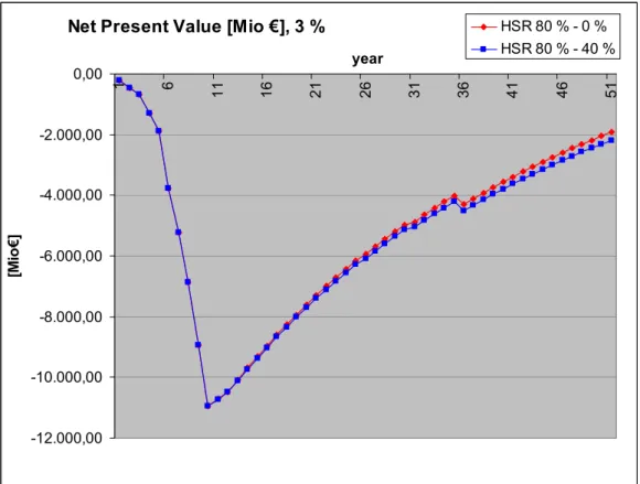
The total investment costs of infrastructure and rolling stock were estimated at 13,700 million €. In the chosen scenario, the transport revenues added up to 873 million € per year. Assuming stable non-petrol energy prices, the operational costs and costs of maintenance were estimated at 308 million € per year, and at 323 million € per year assuming a 40% increase in non-petrol energy prices.
Within an investigated time period of 50 years, revenues and costs will generate a financial internal rate of return (FIRR) of 2.0% with stable non-petrol energy prices, and of 1.8 % assuming a 40% increase in non-petrol energy-prices.
Compared to a calculative interest rate of 3% (which is often used for the calculation of public investments in traffic infrastructure), a FIRR of only 2.0% or 1.8% indicates that the project is not rewarding in a microeconomic view. But this is the case for many investments in public transport infrastructure.
The cashflow of the project is displayed in Figure 8Figure . It shows the typical cashflow character of large investments. Regarding both the investment period and the operating period, the break-even point is not yet reached in the 50 years under review. However, in the microeconomic view of a railway manager, the fact is important that the operating period considered apart would be financially feasible and generate a considerable yearly benefit which can be used as a marginal return of the investment costs. A remarkable point is the negligible effect of a probable increase of the costs of electrical energy.
Figure 8: Cash Flow for 3 % calculative interest rate (start of railway operations in the 11th year) red: high-speed railway, no increase of non-petrol energy costs assumed, blue: high-speed railway, 40 %
increase of non-petrol energy costs assumed (based on [2])
WHAT HAS HAPPENED SINCE THEN?
Since the study was presented in spring 2007, significant changes and developments in the situation of railway strategy and transport policy are to be noted in this fields:
• Maglev Transrapid
• Railway connection Berlin – Dresden – Prague
• Increase of freight rail traffic
• Freight transport strategy of the European Union
• Network strategy of Deutsche Bahn AG
Maglev Transrapid
With the cancellation of the maglev project “Munich Transrapid Airport Link”, there is no realistic perspective for a maglev long-distance transport project in Europe in the next decades – if at all.
Net Present Value [Mio €], 3 %
-12.000,00 -10.000,00 -8.000,00 -6.000,00 -4.000,00 -2.000,00 0,00 1 6 11 16 21 26 31 36 41 46 51 year [Mio € ] HSR 80 % - 0 % HSR 80 % - 40 %
Railway connection Berlin – Dresden – Prague
East German – notably Saxon – policy is endeavouring to achieve that the corridor Berlin – Dresden – Prague is classified as a priority axis in the trans-European railway network. This requires inclusion of the section Dresden - Czech border (- Prague) in the German federal transport network plan. Since the Elbe valley line will have reached its capacity limit in 2015, the Saxon government demands a new line Dresden – Prague. However, Deutsche Bahn does not seem to support this idea. Besides network strategy considerations, the high costs for the necessary long tunnels through the Ore Mountains and the Bohemian Mountains may be a key obstacle. This applies in particular if the new line is laid out for freight train needs, which seems advisable from today’s perspective (see Figure 9 and Figure 10), as explained in the following:
Increase of freight rail traffic
As a result of increasing globalisation and the ensuing high rise in cargo volume handled in the seaports, rail freight traffic has increased more than proportionally in the last years while long-distance passenger rail traffic has stagnated or grown to a minor degree. The impact of the world economic crisis is largely assessed as temporary so that – after a considerable decline over several years – further growth in freight rail traffic is assumed. This particularly concerns the long-distance international traffic, notably between seaport and hinterland.
In addition, the aggravating environmental and climatic problems speak in favour of an expansion of rail freight transport lines. In contrast and owing to its high power consumption in railway terms, high-speed rail traffic with its expensive infrastructure has a much less beneficial impact on the environment than freight rail traffic. In comparison with high-speed traffic, the specific infrastructure expenditures to increase freight rail transport are considerably lower, despite the longer tunnels required in individual cases. A condition for acceptance by the population is, however, that the railway companies manage to reduce the noise emissions by freight rail traffic. This is considered feasible within the next 10 to 15 years if emphasis is put on technical measures to improve the freight cars.
Figure 9: Longitudinal profile of the Ore Mountain crossing for pure passenger transport (dashed: relief of terrain, solid: railway line) (unpublished, 2007)
0 100 200 300 400 500 600 700 800 0,0 5,0 10,0 15,0 20,0 25,0 30,0 35,0 40,0 45,0 Station in km Höhe in m DD-Niedersedlitz Usti n. L. km 25,35 Staatsgrenze BRD /Tschechien Border Germany – Czech Republic km
Figure 10: Longitudinal profile of the Ore Mountain crossing usable for heavy freight transport (dashed: relief of terrain, solid: railway line) (unpublished, 2007)
Freight transport strategy of the European Union
The European Union is increasingly opting for the extension of cross-border freight transport corridors as part of the conventional trans-European railway network (see Figure 11: European ERTMS corridors (based on [7]). An essential means to ensure that these corridors can be used freely is the consistent equipment of infrastructure and engines with ERTMS / ETCS (European Rail Traffic Management System / European Train Control System). Others are the elimination of bottlenecks from the lines and stations of the corridors, and the harmonisation of rules of train operation in the countries concerned. The measures will be financially supported by the EU but will have to be paid mainly by the countries and the railway companies concerned. It is the avowed aim of the EU to link the most important freight transport zones by ERTMS corridors by 2020.
0,0 100,0 200,0 300,0 400,0 500,0 600,0 700,0 800,0 900,0 0,0 5,0 10,0 15,0 20,0 25,0 30,0 35,0 Station in km Höhe in m km 19,48 Staatsgrenze BRD /Tschechien Heidenau Usti n. L. Border Germany – Czech Republic km
Figure 11: European ERTMS corridors (based on [7])
Network strategy of the Deutsche Bahn AG (DB networks)
On account that the company’s business expectations from the development of freight rail traffic have risen, the investment strategy of DB Netz AG is increasingly being focused on freight rail transport - to the detriment of desirable projects in the field of high-speed transport. DB Netz AG has decided on a three-step approach:
• Up to 2013: Immediate action programme “Seaport Hinterland Transport”:
"Low-investment measures” for improvement of the control and safety technology, additional cross-overs, junction curves, extension of passing tracks, some
corresponding measures of the German federal transport network plan, incentives for using alternative routes
• 2013 to 2017: “Growth programme”
Steering of freight rail transport via alternative routes for high-load lines, node measures (see Fig. 12)
• 2017 to 2020: Unfinished measures of the German federal transport network plan Hanover – Hamburg / Bremen (Y line), Stuttgart – Ulm, Karlsruhe – Basel, Rhine / Main – Rhine / Neckar
(Halle/Leipzig – Erfurt 2017 prospective completion)
The function of the east corridor (via Leipzig, Hof and Regensburg, bypassing Nuremberg) included for the first time in the growth programme, is the accommodation of additional southbound traffic to Munich and Passau, as stated by DB AG. This contrasts
significantly with the EU concept containing the ERTMS corridor E via Prague and Dresden, important in particular for the Czech Republic (see Figure 12). It is thus clear that DB AG intends to route the traffic to Southeastern Europe mainly via Passau and not via Dresden, with the advantage of higher train path revenues from this line for Deutsche Bahn.
Figure 12: Freight transport corridors in the “Growth Programme” of DB AG (based on [8])
SUMMARY
Worldwide processes such as globalisation, climate change and increasing environmental impact are leading to a shift of emphasis in the role that railways should play in the future: with freight rail, better climatic and environmental effects can be achieved at less cost than with high-speed passenger rail transport.
In view of this background, it may be expected that, at best in the long term, there will a chance to realise the complete high-speed rail passenger transport connection from Berlin to Budapest via Dresden, Prague and Vienna, especially as this link is not being supported by Deutsche Bahn at present. This is clear to see from the fact that the refurbishment of the
section Berlin – Dresden was repeatedly postponed, but nevertheless is now scheduled to be started.
But one should not succumb to the temptations of playing off the two modes of rail transport, freight and high-speed passenger transport, against each other. Now and in the future, the goal should be to increase the share of traffic in percentage terms for both freight and passenger transport significantly, as traffic volumes continue to grow in absolute terms.
High-speed transport should also not be neglected as it solely captures significant shares of traffic from "overland" air traffic, which consumes fossil resources and pollutes the atmosphere, and this at a significantly better environmental footprint. This dilemma can only be solved by significantly increasing the budgets allocated to rail transport.
Since the passenger transport link Berlin – Dresden – Prague – Vienna – Bratislava is definitely justified, considering the development to be expected in eastern Central Europe in the medium term, the concept of a continuous high-speed link should be further pursued. Furthermore, it is necessary to call for a network concept regarding cross-border high-speed transport in eastern Europe, as this is the only way to prevent that individual high-speed lines in this area will be incompatible with a useful overall concept (see Figure 1).
REFERENCES
[1] SIC! Sustrain Implement Corridor – Vergleichende Untersuchung von
Hochgeschwindigkeitssystemen im Verkehrskorridor Berlin – Sachsen – Praha – Wien – Bratislava – Budapest (Comparative Study on High Speed Systems in the Transport Corridor Berlin – Saxony – Praha – Vienna – Bratislava – Budapest), Ministry of the Interior, Freestate of Saxony, Dresden 2007.
[2] Fengler, W., Platzer, G., 2006. A Study for High Speed Transport in Paneuropean Corridor IV. In: Schach, R., Witt, M., (Eds), Maglev’ 2006 Germany (Proceedings), pp. 759 – 766.
[3] Stephan, A., Fritz, E., 2006. Operating Concept and System Design of a Transrapid Maglev Line and a High-Speed Railway in the Paneuropean Corridor IV. In: Schach, R., Witt, M., (Eds), Maglev’ 2006 Germany (Proceedings), pp. 767 – 779.
[4] Fengler, W., Schach, R., Stephan, A., Stehle, J., 2008. Hochgeschwindigkeitsverkehr: Vorstudie zur Strecke Berlin – Budapest. (High speed Transport: Pre-feasibility Study of the Line Berlin – Budapest). Eisenbahningenieur 03 / 2008, pp. 35 – 43.
[5] SIC! Sustrain Implement Corridor – short factbook.
http://www.landesentwicklung.sachsen.de/download/Landesentwicklung/SIC_ShortFactbook_en_0 60907.pdf
[6] UIC Union Internationale des Chemins de Fer, 2008, http://uic.asso.fr/ [7] UIC Union Internationale des Chemins de Fer, 2005-2006, http://uic.asso.fr/
[8] Müller, Wolfgang, 2009. Upgrade and new conception of the network of DG AG concerning to „Masterplan Rail, Seaport – Hinterland Transport (original: Ausbau- und Neukonzeption des Netzes der DB AG entsprechend „Masterplan Schiene, Seehafen-Hinterland-Verkehr“), speech given on IZBE Symposium „The Masterplan freight transport and logistics – response on the challenges of european freight transport“, Leipzig (2009-04-28/29)
ACCESS TO THE SLOVAK RAILWAY INFRASTRUCTURE
Eva Nedeliaková, Anna Dolinayová University of Žilina
Faculty of Operation and Economics of Transport and Communications Department of Railway Transport
Univerzitná 8215/1, 010 26 Žilina, Slovakia
[email protected], [email protected]
ABSTRACT
The Railways of the Slovak Republic, as the infrastructure manager, shall allocate the infrastructure capacity if the applicant fulfilled the conditions for capacity allocation identified in the published Network Statement and the infrastructure capacity permits it. Train path allocation follows business principles. Transport operator with confirmed capacity is in the advantage when the path is allocated. This paper describes Slovak railway infrastructure manager, legal framework for railway transport, principles of infrastructure development in the Slovak republic and general access conditions as well as presents charges for the use of railway infrastructure as a subject to regulation.
INTRODUCTION
The Railways of the Slovak Republic (ŽSR) were founded on January 1, 1993 by a decision of the Government of the Slovak Republic on establishment of a state company following the split-up of the Czechoslovak Federal Republic and thus the split-up of the Czech and Slovak State Infrastructure into two independent entities.
ŽSR was established by Act No. 258/1993 Coll. on the Railways of the Slovak Republic, under which the activities of a track and track transport operator shall be performed. As of January 1, 2002 ZSR was further divided into two independent entities according to the ŽSR Transformation and Re-organisation Project – into ŽSR and Železničná spoločnosť, a.s. Within the meaning of the approved transformation and restructuring project, ŽSR was transformed by Act No. 259/2001 Coll. into Železničná spoločnosť, a.s., and on amendments and supplements to Act of the National Council of the Slovak Republic No. 258/1993 Coll., with effect as of January 1, 2002. Pursuant to the said legal regulations, the Railways of the Slovak Republic shall undertake activities related to the operation of railway tracks and the management of track transport and operability of railway tracks.
Infrastructure manager provides transport services as well as other related activities in the line with the state transport policy and market demands. The main mission of ŽSR is as follows:
• management and operation of railway infrastructure,
• provision of operation-related services,
• founding and operating of railway, telecommunication and wireless networks,
• construction, regulation and maintenance of railway and funicular infrastructure,
INFRASTRUCTURE DEVELOPMENT
The appropriate railway network density is characteristic for the railway infrastructure. The backbone of the Slovak railway network is a triangle of the tracks: Košice – Žilina, Žilina – Bratislava and Bratislava – Zvolen – Košice.
Railway infrastructure development is focused mainly on the modernization of the tracks which are parts of the pan-European corridors IV, V, VI and which are parts of the TEN-T network. Modernization of the corridors to AGC and AGTC parameters is based on the need of offering the quality ŽSR infrastructure for the international and domestic passenger and freight transport in direction North – South and East-West.
Figure 2 describes Slovak railway infrastructure as a part of pan - European corridors IV, V, VI, TEN-T network and AGC and AGTC agreement.
Upgrading of the rail tracks is co-financed through the EU funds. Table 1 interprets the structure of funds for financing investment expenditures.
Table 1: Structure of funds for financing investment expenditures (EUR) [3]
Funds Year 2009 2010 2011 2012 2013 Equity 92 942 973 92 942 973 92 942 973 92 942 973 92 942 973 State subsidies + co-financing 105 523 468 137 920 733 138 153 090 148 244 042 132 078 603 Structural funds 89 092 478 132 775 675 99 581 757 119 498 108 99 581 757 Cohesion fund 105 058 753 165 969 594 149 372 635 175 927 770 165 969 594 Total 392 617 672 529 608 976 480 050 455 536 612 893 490 572 927
Figure 1: Structure of funds for financing investment expenditures [3]
92.942.973 92.942.973 92.942.973 92.942.973 92.942.973 105.523.468 137.920.733 138.153.090 148.244.042 132.078.603 89.092.478 132.775.675 99.581.757 119.498.108 99.581.757 105.058.753 165.969.594 149.372.635 175.927.770 165.969.594 0% 10% 20% 30% 40% 50% 60% 70% 80% 90% 100% 2009 2010 2011 2012 2013 % year Structure of funds for financing investment expenditures
The European Commission and European Parliament have decided to solve the problems of lack of funds and unsatisfied technical level of infrastructure through financial support to investments of European significance. Company’s own resources make up only 20% of total planed investment expenditures during the period 2006 – 2013. The rest is planned to be financed from the state budget and European funds. [6]
Figure 2: Slovak railway infrastructure as a part of pan - European corridors IV, V, VI, TEN-T network and AGC and AGTC agreement [7]
LEGAL FRAMEWORK
The operation of infrastructure and transport on the network of ŽSR is governed by:
• European legislative regulations,
• National legislative regulations,
• Regulations and technological processes of ŽSR,
• Regulations and technological processes of the transport operator within the scope specified in the abovementioned legislative regulations.
Legislative regulations of the Slovak Republic
Legislative regulations of the Slovak Republic for railway infrastructure are as follows:
• Act of the National Council of the Slovak Republic No 164/1996 Coll. on Railroads and on Amendment to Trade Licensing (Trade Law) No 455/1993 Coll. as amended by later regulation.
• Act of the National Council of the Slovak Republic No 258/1993 Coll. on the Railways of the Slovak Republic as amended by later regulation.
• Ministry of Transport, Posts and Telecommunications Decree No 249/1997 Coll. on the model for the preparation of transport rules on railroads,
• Ministry of Transport, Posts and Telecommunications Decree No. 250/1997 Coll. through which transport rules are issued,
• Decree of The Railway Regulatory Authority No. 545/2008 Coll. valid by 1 January 2008.
GENERAL ACCESS CONDITIONS
Transport operator may operate transport on the national or regional infrastructure on the base of:
• Valid licence for transport operation on the national or regional infrastructure, issued by a competent Member State’s authority,
• Allocated capacity,
• Valid safety certificate,
• Track access agreement concluded with the infrastructure manager,
• Insurance,
• Agreement with the Institution of Railways protection against fire – applicable for freight transport,
• Agreement with the Railway power stations in the event that the operator will operate transport with traction units with dependent traction.
Conditions for submitting a request to obtain a licence, safety certificate and their content are defined by the NC SR Act No 164/1996 Coll. on Railroads and on Amendment to Trade Licensing (Trade Law) No 455/1993 Coll. as amended by later regulation.
Licence in the Slovak Republic is issued, withdrawn and controlled by Authority for Railways Transport Regulation (ÚRŽD). ÚRŽD at the process of decision making defines conditions for transport operation on the infrastructure related mainly to the securing of regional transport needs and transport safety on the infrastructure.
Licence issued by a competent authority of a Member State is valid on the whole region of the Slovak Republic. It is necessary to submit the licence to ÚRŽD in order to issue a safety certificate.
On the day of launching the transport operation on national or regional tracks operated on the base of the licence, the transport operator must have a safety certificate. Safety certificate is issued by ÚRŽD on the base of transport operator request.
The rights and obligations of the applicant and ŽSR in the relation to the allocated infrastructure capacity define framework agreement. Framework agreement is legally binding general agreement concluded in terms of public or private law for the period longer that the validity of a train timetable.
Framework agreements are generally concluded for the period of 5 years. In specific cases and after a mutual approval it is possible to conclude this agreement for shorter or longer period.
Between the infrastructure manager (ŽSR) and the applicant is concluded Contract on the transport operation on the rail infrastructure in administration of ŽSR, containing requirements and conditions for transport operation on the rail infrastructure.
Capacity allocation
Transport operator shall submit the capacity request to the competent ŽSR GD Depart
![Table 1: Financing road network expansion in Poland [7]](https://thumb-us.123doks.com/thumbv2/123dok_us/308258.2533003/13.892.106.795.635.846/table-financing-road-network-expansion-poland.webp)
![Table 3 Financial resources for rail infrastructure in Poland, 2010-2015 [11]](https://thumb-us.123doks.com/thumbv2/123dok_us/308258.2533003/14.892.97.795.359.480/table-financial-resources-rail-infrastructure-poland.webp)
![Table 4: Green Lungs of Poland, basic data [3]](https://thumb-us.123doks.com/thumbv2/123dok_us/308258.2533003/15.892.105.794.484.876/table-green-lungs-of-poland-basic-data.webp)
![Figure 2: Birds Directives in the area of Green Lungs of Poland [1]](https://thumb-us.123doks.com/thumbv2/123dok_us/308258.2533003/16.892.174.719.611.1004/figure-birds-directives-area-green-lungs-poland.webp)
![Figure 3: Stations and system edges [2]](https://thumb-us.123doks.com/thumbv2/123dok_us/308258.2533003/22.892.122.780.111.655/figure-stations-edges.webp)
![Figure 5: Route variants (red: railway, blue: maglev train) [2]](https://thumb-us.123doks.com/thumbv2/123dok_us/308258.2533003/23.892.124.768.393.998/figure-route-variants-red-railway-blue-maglev-train.webp)
![Figure 6: Distances and scheduled running times of the high-speed railway line [3]](https://thumb-us.123doks.com/thumbv2/123dok_us/308258.2533003/24.892.115.789.349.732/figure-distances-scheduled-running-times-high-speed-railway.webp)
![Figure 7: Traffic forecast for a high-speed railway line Berlin – Budapest [3]](https://thumb-us.123doks.com/thumbv2/123dok_us/308258.2533003/25.892.108.797.231.618/figure-traffic-forecast-high-speed-railway-berlin-budapest.webp)