October 2010
Dufferin County
ACtive trAnsportAtion AnD
trAils (DCAtt) MAster plAn
TABLE OF CONTENTS
1 Introduction ... 1
1.1 What is an Active Transportation (AT) and Trails Master Plan? ... 1
1.2 Benefits of Active Transportation and Trails ... 2
1.2.1 Health and Fitness Benefits ... 2
1.2.2 Transportation Benefits ... 3
1.2.3 Environmental Benefits ... 5
1.2.4 Economic Benefits ... 7
1.3 Vision, Goals, Objectives ... 9
1.4 The Study Process ... 10
1.5 Organization of the DCATT Master Plan ... 11
2 Policy and Planning Context for AT and Trails in Dufferin County ... 13
2.1 Community Profile ... 13
2.2 Existing Policies and Initiatives ... 18
2.2.1 Federal ... 18
2.2.2 Provincial ... 19
2.2.3 Dufferin County ... 24
2.2.4 Local Municipalities ... 25
2.2.5 Headwaters Communities in Action ... 28
3 Public Consultation ... 31
3.1 Consultation Process ... 31
3.1.1 Communication and Consultation Strategy ... 31
3.1.2 Key Audiences ... 31
3.1.3 Consultation Activities ... 32
3.2 What the Public Told Us ... 33
3.2.1 Online Survey Results ... 34
4 The Active Transportation Network ... 37
4.1 Introduction... 37
4.2 The Network Development Approach ... 38
4.3 Inventory of Existing Conditions ... 39
4.4 Route Development and Selection Principles ... 41
4.4.1 Headwaters Communities in Action ... 41
4.4.2 Town of Orangeville Trails Master Plan ... 41
4.4.3 Town of Shelburne Active Transportation Study ... 42
4.4.4 Town of Mono Trail Network Study ... 42
4.4.5 Route Selection Principles for the DCATT Network ... 42
4.5 Candidate Routes ... 44
4.7 Proposed Network Facility Types ... 47
4.7.1 Multi-use Trails ... 47
4.7.2 Rails with Trails ... 49
4.7.3 On-road Routes ... 50
4.7.4 Pedestrian Facilities ... 55
5 Implementation ... 57
5.1 The Implementation Strategy ... 57
5.2 How to Implement the Master Plan ... 57
5.3 Building the Network ... 57
5.3.1 Network Implementation Schedule and Priorities ... 58
5.3.2 Construction Costs ... 60
5.3.3 Additional Considerations for Route Implementation ... 64
5.3.4 Network Maintenance ... 66
5.4 Outreach ... 67
5.4.1 Working with Others ... 67
5.4.2 Education ... 71
5.4.3 Encouragement... 73
5.4.4 Enforcement ... 74
6 Funding and Partnership Strategies ... 77
6.1 Where Will the Money Come From? ... 77
6.2 Why Should the County Make the Investment? ... 78
7 Measuring Success ... 79
8 Next Steps... 81
Appendix A ... 83
The DCATT Master Plan is the product of the hard work and effort of many people. The study team would like to thank the members of the Project Steering Committee, the HCIA, the public, agency representatives and stakeholders who gave their time and energy in the development of this Master Plan, especially those who participated in the public meetings, completed the on-line survey, and the many others who provided written or verbal input.
On behalf of the study team and all those who contributed to this Master Plan, it is our hope that the Dufferin County Active Transportation and Trails Master Plan provides the County and its partners with the tools and guidance necessary to improve conditions for active transportation well into the future.
1
INTRODUCTION
1.1
What is an Active Transportation (AT) and Trails Master
Plan?
The County of Dufferin has developed a comprehensive Active Transportation and Trails Master Plan that builds upon and will support and strengthen the trails and active transportation planning initiatives of local municipalities in the County. The Dufferin County Active Transportation and Trails (DCATT) Master Plan consists of a network of both on and off-road trails designed to connect the urban and rural communities of Dufferin County and promote active transportation and active recreation. The County initiated this study in May 2009 under the direction of a study team of stakeholders led by the County’s Director of Public Works.
The DCATT Master Plan focuses primarily on non-motorized modes of transportation (hiking, cycling, walking, cross-country skiing, etc.) on County Roads, through forests and other lands owned by the County. In addition, existing and proposed routes in the Town of Orangeville Trails Master Plan (2008), the Town of Shelburne Active Transportation Plan Study (2008) and the Town of Mono Trails Network Study (2000) have been considered in the preparation of the County’s plan. A key input in the development of the DCATT Plan was the insight gained from public consultations led by the Headwaters Communities in Action (HCIA) group in 2007/2008, a local citizen-based group.
In addition, HCIA’s Trail Sub-Committee produced a report called “Building a
Regional Network of Trails” which outlined a comprehensive set of recommendations and proposed routes that have proven to be a key resource in the creation of the DCATT Master Plan.
Recent initiatives by the provincial government, including the Greenbelt Plan
and Places to Grow, will further increase the intensification of existing urban and settlement areas. One of the provincial strategies is to build communities that are pedestrian, cycling and transit-supportive. The DCATT Master Plan considers planning and policy initiatives at the local, regional and provincial levels, and contains short and long-term actions and recommendations designed to establish and support a desired level of active transportation for Dufferin County.
Active transportation as defined in the context of the DCATT includes the
following four components:
The DCATT Master Plan considers planning and policy initiatives at the local, regional and provincial levels, and contains short and long-term actions and
recommendations designed to establish and support a desired level of active
transportation for Dufferin County.
Active Commuting - which involves journeys to and from work;
Active Workplace Travel - which includes trips during working hours such as the delivery of materials or attending meetings;
Active Destination Oriented Trips - which includes trips to and from school, shops, visiting friends and running errands; and,
Active Recreation - which involves the use of an active transportation mode for fitness or recreational pursuits, such as hiking or cycling.
1.2
Benefits of Active Transportation and Trails
There exists a clear body of evidence that walking and cycling provide significant health, transportation, environmental and economic benefits. Municipalities in Ontario and throughout North America are implementing initiatives to promote and encourage walking and cycling as feasible alternatives to the private automobile for short-distance trips and as a method of promoting a more active and healthy lifestyle.
1.2.1 Health and Fitness Benefits
Walking and cycling provide an enjoyable, convenient and affordable means of exercise and recreation. Research suggests the most effective fitness routines are moderate in intensity, individualized and incorporated into our daily activities. In 2001, approximately $2.8 billion was spent on health care due to physical inactivity in Canada, which could be reduced by $280 million if physical activity was increased by 10%. Our health system is shifting from protecting people from hazards in the environment to developing healthy environments in which people can live. Evidence suggests that improved cycling and trail facilities lead
to increased bicycle and trail use.1
Increased physical activity such as walking, cycling and other trail related activities could help to reduce the risk of coronary heart disease, premature death, high blood pressure, obesity, adult-onset diabetes, depression and colon cancer. A more active population in the County of Dufferin can reduce the cost of medical care, decrease workplace absenteeism, and maintain the independence of older adults.
Sedentary lifestyles have serious consequences for public health. The most visible is the sharp rise in obesity across Canada in recent years. Almost half of Canadians ages 12 and over report being physically inactive and 26% of youth
1 Bridging the Gaps: How the Quality and Quantity of a Connected Bikeway Network Correlates with Increasing Bicycle Use, July 27, 2005, Mia Burke and Roger Geller
Increased physical activity such as walking, cycling and other trail related activities could help to reduce the risk of coronary heart disease, premature death, high blood pressure, obesity, adult-onset diabetes, depression and colon cancer.
Our health system is shifting from
protecting people from hazards in the environment to developing healthy environments in which people can live.
between the age of 2 and 17 years old are overweight or obese (Statistics Canada 2005). In Canada, the prevalence of obesity has more than doubled in the last 20 years (Katzmarzyk & Mason, 2006).
Obesity is associated with serious health conditions, notably increased risks of diabetes and cardiovascular diseases. Physical inactivity contributes substantially to the global burden of disease, death and disability. Increasing walking and cycling, and reducing Canadians’ reliance on cars, can increase physical activity levels, lower the risk of obesity, lower the risk of hospitalizations from asthma and address other health conditions such as heart disease, some cancers and type 2 diabetes caused by inactivity.
There are other health benefits in addition to the physical fitness gains. Cycling and trail use can enhance one’s mental outlook and well-being, improve self-image, social relationships and increase self-reliance by instilling a sense of independence and freedom. These can contribute to healthier and happier personal relationships, and improve work and school productivity.
Improving active transportation methods such as walking and cycling and reducing automobile traffic can help make communities more liveable by creating an environment that is pleasant and safe with reduced noise and pollution. This can help to encourage more social interaction within a neighbourhood and create a stronger sense of community. Active transportation (AT) modes can provide a form of mobility for people who do not have regular access to an automobile and live in communities with limited transportation choices.
Making strategic investments, through partnerships when feasible, in both infrastructure and outreach to support walking and cycling in daily commuting habits, fitness and active recreation can help to promote a healthy and active lifestyle for Dufferin County residents and can have other valuable benefits.
1.2.2 Transportation Benefits
Walking and cycling are both popular recreational activities and a means of transportation that are efficient, affordable and accessible. They are the most energy efficient modes of transportation, and generate no pollution. The transportation benefits of walking and cycling include reduced road congestion and maintenance costs, less costly infrastructure, increased road safety and decreased user costs. For distances up to 10 km in urban areas, cycling can be the fastest of all modes from door to door.
Walking and cycling are both popular recreational activities and a means of transportation that are efficient, affordable and accessible. They are the most energy efficient mode of transportation and generate no pollution.
Canadians make an average of 2,000 car trips per year over distances less than 3 km. Surveys show that 66% of Canadians would like to cycle more than they presently do. Seven in ten Canadians say they would cycle to work if there “were a dedicated lane which would take me to my workplace in less than 30
minutes at a comfortable pace”.2
These facts clearly demonstrate the potential for increasing the number of trips by bicycle, especially in the more urban areas of the County.
There is strong evidence that given complete networks of high-quality cycling routes, a significant number of people will cycle. The value of such complete networks is demonstrated in many communities particularly Portland, Oregon, Davis, California and Boulder, Colorado. With between 10% and 20% of trips by bicycle, these communities have the highest levels of bicycle usage in North America. This high level of cycling is facilitated by mature networks, which include bike lanes on almost all of their arterial roads and extensive off-road commuter bicycle paths. Residents can simply get on their bicycles with confidence knowing there will always be a safe route to their destination (British Columbia Cycling Coalition Budget Submission, 2007).
The addition of even a small volume of traffic to a congested road can create enormous delays for all users. In fact, at capacity conditions, increasing traffic by 5% can reduce speeds by up to 25%. Congestion costs in Ontario were estimated to be $6.4 billion annually and could grow by an additional $7 billion annually by 2021 without increased investment in alternative modes of
transportation.3
Shifting a little traffic off busy roads can create substantial time
savings for individuals as well as for time-sensitive commercial vehicles.4
It has been estimated that due to rising gasoline prices, more than 10 million cars – mostly belonging to low income families – will disappear in the US in the next five years, and a similar trend is expected in Canada (CIBC World Markets, 2008). Providing safe options for bicycle and pedestrian travel is going to become increasingly important for all communities, including Dufferin County and its local municipalities.
Typical roadway funding requirements include maintenance costs, safety and enhancement costs plus the addition of roadway capacity through lane widening
2
Ontario Trails Strategy, Ministry of Health Promotion, 2005, Province of Ontario.
3
Transportation Demand Management Strategy, City of Ottawa - TravelWise (Transportation, Utilities and Public Works), April 2003.
Providing safe options for bicycle and pedestrian travel is going to become increasingly important for all communities, including Dufferin County and its local municipalities.
or additions. Furthermore, the costs for road construction, reconstruction and maintenance are usually paid for by road users through property and gas taxes. An emphasis on walking, cycling and other active transportation modes can result in a reduction in roadway costs. For example, bicycles are lightweight vehicles that take up little space and cause little wear and tear on a road surface. Road improvements to increase the safety of pedestrians and cyclists can and should enhance the safety of other road users. The U.S. Federal Highway Administration reports that paved shoulders on two-lane, rural roads have been shown to reduce run-off-the-road, head-on and sideswipe collisions by 30% to 40%. In addition, many municipalities have found that paved shoulders reduce maintenance costs related to shoulder deterioration, grading and snow removal. A roadway can carry 7 to 12 times as many people per lane per hour by bicycle compared to that of motor vehicles in urban areas operating at similar speeds. It is also much cheaper to provide paved shoulders on a road for cyclists than to provide two additional motor vehicle travel lanes. A small portion of a municipality’s transportation budget can be used to facilitate high levels of bicycle use.
Another benefit of reduced car use is a decrease in the number of parking spaces required. For example, encouraging more people to walk and cycle to work could lead to a reduction in the number of parking spaces required at a place of employment. Bicycle parking facilities could be provided in an existing surface or underground parking lot with no additional parking lot expansion required.
1.2.3 Environmental Benefits
Walking and cycling are energy-efficient, non-polluting modes of travel. Short distance motor vehicle trips are the least fuel efficient and generate the most pollution per kilometre. These trips have the greatest potential of being replaced by walking or cycling trips and integrated walking-transit and cycling-transit trips.
Reducing the number of motor vehicles on the road decreases the number of pollutants that are emitted into the atmosphere by motor vehicles. Climate change is another problem that can be mitigated by encouraging drivers to use other modes, or to travel outside rush hours. Motor vehicles, roads and parking facilities are major sources of water pollution and hydrologic disruptions due to such factors as road de-icing, air pollution settlement, roadside herbicides, road construction along shorelines, and increased impervious surfaces.
Road improvements to increase the safety of pedestrians and cyclists can and should enhance the safety of other road users.
Climate change is another problem that can be mitigated by encouraging drivers to use other modes, or to travel outside rush hours.
Motor vehicles generate various types of unwanted noise that cause disturbance and discomfort to residents. This includes engine acceleration, tire/road contact, braking, horns and vehicle theft alarms. Bicycles make little noise, and are not disruptive to communities from a noise perspective. Automobile dependent communities require more land for road rights-of-way and parking than communities that are not as reliant on the automobile. Making communities less auto-dependant by providing infrastructure for alternative transportation modes, such as walking, cycling and public transit, can reduce the amount of land required to construct new communities, thus creating more compact subdivisions that make more efficient use of available land.
Given the important role that cycling plays in reducing emissions of air pollutants and greenhouse gases, and fostering good health directly, it is important to create bicycle connectivity that has the potential to create a desirable cycling environment. A literature and best practices review suggests that the number of beginner or infrequent cyclists increases when:
Neighbourhoods and communities accommodate a cycling network that
includes bike lanes and off-road cycling or multi-use trails;
Roads with speeds over 60km/h have separated lanes or wider paved
shoulders that are part of the road, not sidewalk, infrastructure;
Roads with speeds between 50-60 km/h have marked bicycle lanes;
Roads with speeds under 40 km/h are shared;
Priority is given to cyclists in intersections;
Residents have access to trip end facilities such as secure long-term bicycle
parking (e.g. lockers), secure short-term bicycle parking (e.g. bicycle racks), and showers in commercial buildings; and
All streets, roadways, and designated bike routes are maintained to be free of
deterrents to bicycling (such as potholes, debris, and overgrown landscaping).
In order to support the inclusion of these community design elements in future development in Dufferin County, it would be helpful if local municipalities incorporated in their planning policy a walking and cycling
review for cycling and pedestrian connectivity and safety for planning
applications.5
5
Creating Walkable and Transit-Supportive Communities in Halton, Halton Region, February 2009 Short distance, motor
vehicle trips are the least fuel efficient and generate the most pollution per kilometre. These trips have the greatest potential of being replaced by walking or cycling trips and integrated walking-transit and cycling-transit trips.
1.2.4 Economic Benefits
A study published by Go for Green in March of 2004 establishes a convincing Business Case for Active Transportation in the report entitled “The Economic
Benefits of Walking and Cycling”.6
These benefits include a reduction in:
Road construction, repair and maintenance costs;
Costs due to air pollutants and greenhouse gas emissions;
Health care costs due to increased physical activity and reduced respiratory
and cardiac disease;
Fuel, repair and maintenance costs to users;
Costs due to increased road safety;
External costs due to traffic congestion;
Parking subsidies;
Costs due to air pollution; and
Costs due to water pollution.
Benefits also include:
The positive economic impact of bicycle tourism;
The positive economic impact of bicycle sales and manufacturing;
Increased property values along greenways and trails and in pedestrian and
cycling friendly neighbourhoods; and
Increased productivity and a reduction of sick days and injuries in the
workplace.
There is ample evidence to show that on and off-road trails provide significant economic benefits for adjacent landowners and local businesses. Trails provide benefits to the local economy during both construction and operation. Trail construction results in direct benefits such as jobs, including the supply and installation of materials.
Following construction, benefits emerge in the form of expenditures by trail users.
6
The Business Case for Active Transportation, Go for Green, Better Environmentally Sound Transportation - BEST, March 2004.
There is ample evidence that on and off-road trails provide significant economic benefits for adjacent landowners and local businesses.
A few examples include:
The Adanac Bikeway in Vancouver was completed in 1993 and bicycle
volumes increased 225% during the period from 1992 to 1996;
Trails in New Brunswick employ around 1,500 people for an average of six
months per year;
70% of Bruce Trail users cite the trail as the main reason for visiting the area,
and they spend an average of about $20 per user per visit within a 10 km corridor on either side of the trail;
Annual expenditures linked to La Route Verte rose to $95.4 million in 2000,
representing 2,000 jobs and $15.1 million and $11.9 million for the governments of Quebec and Canada, respectively;
In 2002, Quebec hosted 190,000 bicycle tourists who spent an average of
$112 per day and an average of 6.5 nights compared to $52 per day and an average of 3.1 nights spent by other tourists;
In Ontario, the Eastern Ontario Trails Alliance estimated that at the end of a
ten year build-out period, 320 km of their system, constructed at a cost of $5.4 million, will generate approximately $36 million in annual economic benefits in the communities through which it passes, and create/sustain over 1,100 jobs;
The “National Human Powered Mobility Network” in Switzerland,
comprised of nine national cycling routes totalling 4,500 km has an estimated annual economic benefit of $130 million from spending on food and lodging,
with 4,500 tours and 24,000 room nights accounted for in 2008;7 and
According to the Dutch National Cycling Platform, tourists using their
system annually spend an average of €20,000 per kilometre versus an annual maintenance and development cost of €110 per kilometre.
On and off-road trails systems can be travel destinations in themselves, encouraging visitors to extend their stay in the area or enhancing business and pleasure visits. By increasing a tourist’s stay every additional night’s lodging and meals, results in a direct new benefit to local businesses. A 1997 survey of Canadian tourists active in the outdoors showed that 30% of Ontario tourists cycled on at least one occasion while on vacation. The Ontario Ministry of Transportation reported that touring cyclists spend an average of $130 per day in Ontario, and bicycle retail and tourist industry contributes to a minimum of $150 million a year to the Ontario economy. Bed and breakfast operators
7
Ontario Cycle Tourism Forum (January 23, 2009), Toronto, Ontario. Notes by Rob Romanuk, Region of Niagara Bike Committee.
By increasing the level of tourist draw, travelers can be expected to stay longer, resulting in an additional night’s lodging and meals, a major direct new benefit to local businesses.
between Ottawa and Kingston report that the majority of their business is from touring cyclists. Cyclists in Vermont spend an average of $180 U.S. per day, the same amount as someone traveling by car.
Apart from tourism and recreation, the manufacture, sale and repair of bicycles all contribute to the economy. In 2002, Canadian households spent an average of
$42 on bicycles, parts and accessories for a total of approximately $500 million.8
Over the last ten years, the concept of community trail networks and active transportation has been gaining popularity in part because the health, social, environmental, and economic benefits are so substantial. There is clear evidence that pedestrian and cycling friendly communities are more sustainable, liveable communities and encouraging people to walk and bike more often for both
recreation and utilitarian purposes benefits almost every sector of society. The
County of Dufferin should play an important role in providing AT network facilities that connect communities in the County, and support local municipal tourism and active transportation and active recreation network development efforts by considering cycling and pedestrian enhancements to County Roads in urban areas when they are scheduled for improvements.
1.3
Vision, Goals, Objectives
An active transportation and trails master plan should be guided by goals, objectives and principles but it should also establish a vision or target to guide implementation. The following vision for the DCATT Master Plan was prepared in the initial stage of the study and confirmed through the public and stakeholder consultation process.
Vision
Dufferin County is a pedestrian and cyclist supportive community that encourages active transportation for both utilitarian and recreational travel through:
Ensuring that streets accommodate pedestrians and cyclists;
Establishing promotional and educational policies and programs including a
coordinated marketing strategy to encourage active transportation year-round in partnership with HCIA and others; and
8
The Business Case for Active Transportation, Better Environmentally Sound Transportation - BEST, Go for Green, March 2004. Section 4.5.4, pg. 24.
An Active Transportation Master Plan should be guided by goals, objectives and principles but it should also establish a vision that will result from successful implementation.
Implementing a County-wide visible and connected active transportation network of on and off-road facilities designed with safety in mind that are comfortable, convenient, and accommodate the needs of existing and future users.
Goals for the Active Transportation and Trails Master Plan Study
A following set of proposed goals for the DCATT Master Plan was drafted and reviewed with the study team, stakeholders and the public:
Build upon the existing work that has already been completed through other
studies and initiatives;
Develop a network which allows people of all ages and abilities to utilize
facilities for both recreational and utilitarian purposes;
Increase the level of active transportation and trail use throughout Dufferin
County;
Look at opportunities for on and off-road facilities within both the urban and
rural areas of the County that link the larger urban areas; and
Develop effective public consultation methods to gauge public opinion on
the development of future active transportation and trails facilities.
1.4
The Study Process
The DCATT Master Plan was initiated in May 2009. MMM Group Limited was retained by the County to assist staff in the development of a comprehensive Master Plan to identify links and extensions of existing trails and bikeways, as well as new connections throughout the County. The DCATT Master Plan is also designed to identify priorities for network implementation and appropriate levels of funding for operations and maintenance. The DCATT study approach included the following two phases:
Phase 1: Assemble, Review and Confirm – The first phase in the study was the
assessment of background information with a focus on compiling and analyzing information related to active transportation. The first phase also identified the purpose and approach for the study, as well as a consultation and communication strategy; highlighted some of the benefits to walking, cycling and active transportation; summarized key regional, provincial and federal policies regarding walking, cycling and active transportation; and examined innovative and best practices in pedestrian and cycling facility design from across North America and internationally. The Phase 1 Background Report documented this phase of the study, and included maps of existing and previously proposed
pedestrian and cycling facilities, as well as the locations of preliminary existing barriers and opportunities for improved AT system for Dufferin County.
Phase 2: Development of the Active Transportation Master Plan – Based on
the technical assessments and background information review conducted in Phase 1, draft active transportation network and supporting strategies were developed in Phase 2. The Phase 2 Network Report documents the existing context for the study, the network development approach that was followed, and the alternative Active Transportation facility types that are proposed to form the network. This phase also included the development of a set of guidelines for the planning, design and operation of active transportation (walking and cycling) facilities. The Planning and Design Guidelines are in a separately bound Technical Appendix available at the County office.
1.5
Organization of the DCATT Master Plan
The DCATT Master Plan Report is comprised of eight sections which are equally important to the overall understanding of the DCATT Master Plan and its success. Sections 1.1-1.4 have outlined the definition and benefits to the community for active transportation and trails, and provide a vision and set of goals for the Master Plan.
Section 2 details the context of this Master Plan as it relates to Dufferin County and why there is a need for an active transportation and trails master plan at the regional level. Section 3 summarizes the plan’s public consultation process. Section 4 outlines the Active Transportation and Trails Network that has been selected for the County and what the selection process for the various routes entailed. Section 5 examines the ways in which this Master Plan can be implemented and the various strategies that can be employed to ensure that the Active Transportation and Trails Network is a success. Section 6 highlights ways in which funding can be raised for the project and outline partnership strategies that could be employed. Section 7 summarizes the ways in which the success of the plan can be measured. Finally, Section 8 outlines the next steps to move forward in order to effectively begin to implement the DCATT Master Plan.
2
POLICY AND PLANNING CONTEXT FOR AT
AND TRAILS IN DUFFERIN COUNTY
2.1
Community Profile
A community profile was generated for Dufferin County and all of its lower level municipalities based on selected indicators from the latest publicly available Statistics Canada Census (2006) data. The indicators selected were:
Total population
Population density per square kilometre
Land area
Median age of the population
Median household income
Mode of transportation to work/mode share
The community profiles are presented below in Table 2-1. The same data is
presented graphically in Figures 2-1 to 2-6, and illustrate the breakdown profile
indicators across the County and all of its lower level municipalities.
Table 2-1: Community Profile Summary
Indicator Dufferin
County Orangeville Shelburne Mono Amaranth
East
Garafraxa Melancthon
East Luther
Grand Valley Mulmur
Total population 54,436 26,925 5,149 7,071 3,845 2,389 2,895 2,844 3,318
Population density (per square km) 36.6 1,729.30 798.9 25.50 14.50 14.40 9.30 18.00 11.60
Land area (square km) 1,485.58 15.57 6.44 277.67 264.35 165.72 310.88 158.2 286.73
Median age of the population 37.7 35.4 36.5 42.5 40.2 40.5 39.2 37.4 42.3
Median household income (2005) $70,688 $69,154 $61,643 $ 89,619 $77,005 $81,286 $73,175 $68,644 $76,454 Mode share
Car; truck; van; as driver 83.80% 81.30% 83.30% 86.15% N/A N/A N/A N/A N/A
Car; truck; van; as passenger 8.50% 9.10% 6.80% 9.54% N/A N/A N/A N/A N/A
Public Transit 0.80% 1.20% 0% 0% N/A N/A N/A N/A N/A
Walked or bicycled 6.00% 7.40% 8.90% 3.54% N/A N/A N/A N/A N/A
All other modes 0.90% 1.00% 1.00% 0.62% N/A N/A N/A N/A N/A
Total 100% 100% 100% 100% N/A N/A N/A N/A N/A
Statistics Canada does not provide mode share information for Amaranth, East Garafraxa, Melancthon, East Luther Grand Valley and Mulmur.
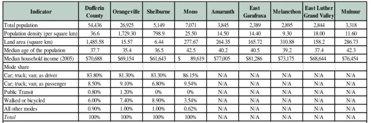
Figure 2-1 - Total Population 54,436 26,925 5,149 7,071 3,845 2,389 2,895 2,844 3,318 0 10,000 20,000 30,000 40,000 50,000 60,000 P o p u la ti o n D ufferi n C ou nty Ora ng ev ille Sh elb urn e M ono Amara nth Ea st G ara fra xa M ela ncth on Ea st Lu th er G ra nd Va lley M ulm ur Municipality
Figure 2-2 – Population Density
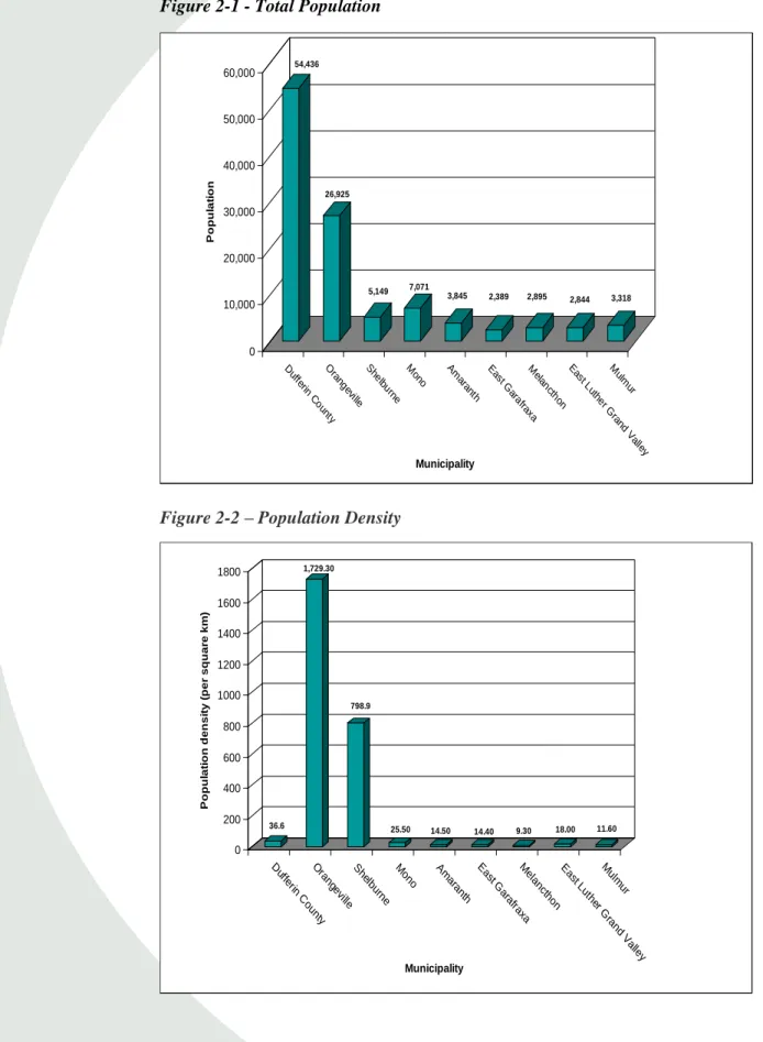
36.6 1,729.30 798.9 25.50 14.50 14.40 9.30 18.00 11.60 0 200 400 600 800 1000 1200 1400 1600 1800 P o p u la ti o n d e n s it y ( p e r s q u a re k m ) D uffer in C ou nty O ra ng evi lle S helb urne M ono Am ara nth E ast G ara fraxa M ela nct hon E ast L uth er G ra nd V alley M ulm ur Municipality
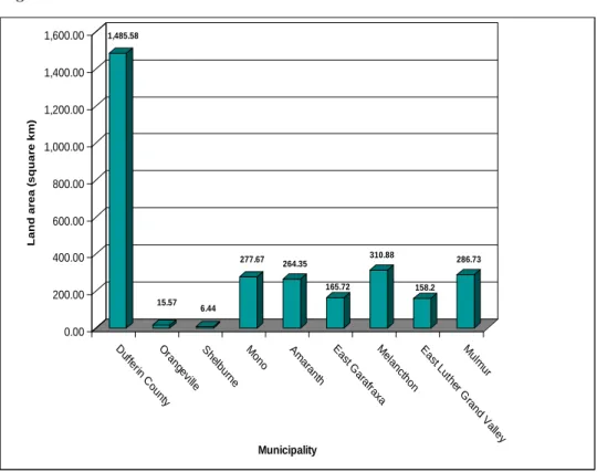
1,485.58 15.57 6.44 277.67 264.35 165.72 310.88 158.2 286.73 0.00 200.00 400.00 600.00 800.00 1,000.00 1,200.00 1,400.00 1,600.00 L a n d a re a ( s q u a re k m ) D uffer in C ou nty O ra ng evi lle S helb urne M ono Am ara nth E ast G ara fraxa M ela nct hon E ast L uth er G ra nd V alley M ulm ur Municipality
Figure 2-1 identifies the population of each of the municipalities selected to create a profile for the County based on 2006 Statistics Canada data. The population of Dufferin County is 54,436 with the Town of Orangeville (26 925) accounting for almost half of that total.
Figure 2-2 compares the population density of the County and all its lower level municipalities. Orangeville, in particular, and Shelburne can be identified as the urban areas of the County. Dufferin County as a whole has a population density of 36.6 persons per square km.
Figure 2-3 – Land Area
Figure 2-3 illustrates the land area for each municipality and indicates that Dufferin County’s land area is approximately 1500 square kilometres.
Orangeville and Shelburne while being the largest of the municipalities by population are the smallest by land area by a considerably large margin. Melancthon, Mulmur and Mono are the largest municipalities in land area.
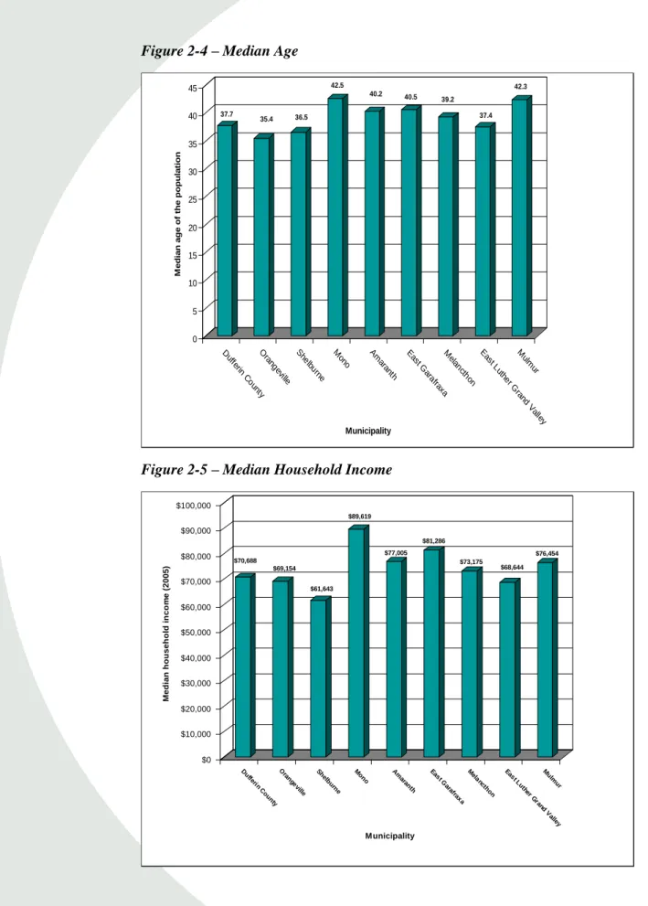
Figure 2-4 – Median Age 37.7 35.4 36.5 42.5 40.2 40.5 39.2 37.4 42.3 0 5 10 15 20 25 30 35 40 45 M e d ia n a g e o f th e p o p u la ti o n D ufferi n C ou nty Ora ng ev ille Sh elb urn e M ono Amara nth Ea st G ara fra xa M ela ncth on Ea st Lu th er G ra nd Va lley M ulm ur Municipality
Figure 2-5 – Median Household Income
$70,688 $69,154 $61,643 $89,619 $77,005 $81,286 $73,175 $68,644 $76,454 $0 $10,000 $20,000 $30,000 $40,000 $50,000 $60,000 $70,000 $80,000 $90,000 $100,000 M e d ia n h o u s e h o ld i n c o m e ( 2 0 0 5 ) D ufferi n C ou nty O ra ng ev ille Sh elb urne M ono Am ara nth Ea st G ara fra xa M elanc th on Ea st Lu th er G rand V alley M ulm ur Municipality
Figure 2-4 highlights the median age for Dufferin County and its lower level municipalities. The median age range goes from 35.4 years (Orangeville) to 42.5 years (Mono). The median age range for the entire County is 37.7 years.
Figure 2-5 highlights the median household income for Dufferin County and its lower level municipalities. Shelburne has the lowest median household income at the range goes from $61,643, while Mono has the highest at $89,619 .The median household income for the entire County is $70,688.
Figure 2-6 – Travel Mode
83. 80% 8.5 0% 0.80% 6. 00% 0.9 0% 81. 30% 9.1 0% 1.2 0% 7.4 0% 1.0 0% 83. 30% 6.8 0% 8.90% 1.0 0% 86. 15% 9.5 4% 3.5 4% 0.6 2% 0.00% 10.00% 20.00% 30.00% 40.00% 50.00% 60.00% 70.00% 80.00% 90.00% 100.00% P e r c e nt a ge ( % )
Dufferin County Orangeville Shelburne Mono
Municipality
Car; truck; van; as driver Car; truck; van; as passenger Public Transit
Walked or bicycled All other modes
Figure 2-6 illustrates the travel mode split to work with the County and its municipalities. According to Statistics Canada, Dufferin County has a walking and/or cycling mode split of 6.0%. Orangeville and Shelburne have a slightly higher rate of walking and/or cycling than the County as a whole, while Mono’s walking and/or cycling split is lower the County’s split. Automobile use, as a driver, remains the most popular mode of transportation with usage levels above 80% across the County and its three largest urban centres. Statistics Canada does not provide travel mode split information for Amaranth, East Garafraxa, Melancthon, East Luther Grand Valley and Mulmur.
2.2
Existing Policies and Initiatives
This section identifies and discusses key policies that directly influence active transportation including cycling and walking in Dufferin County. These existing policies provide an understanding of the current policy framework and establish a base for the Dufferin County Active Transportation and Trails Master Plan to build upon.
Policies pertaining to transportation, including cycling, pedestrians, transit, trails and alternative modes of transportation are provided by the Province. The Town of Orangeville Trails Master Plan, Town of Shelburne Active Transportation Plan Study, and Headwaters’ Trails Working Group’s “Building a Regional Network of Trails” Report have provided a base of cycling, pedestrian, transit and alternative modes of transportation policies to work from. Other local municipalities in the County also have AT and/or Trail supportive policies.
2.2.1 Federal
Transport Canada released a report in 2005 titled “Strategies for Sustainable Transportation Planning: A Review of Practices and Options”. The purpose of this report is to provide a foundation on which to build a set of guidelines for incorporating sustainable transportation principles into municipal transportation
plans.9
Some of these principles include the creation of policies related to walking and cycling that can be used to develop effective, implementable
transportation plans that promote sustainable transportation on a federal level.
Some relevant strategies and policies are listed below: Integration with Land Use Planning
Encourage desirable land use form and design (e.g. compact, mixed-use,
pedestrian/bike-friendly) through transportation plan policies. Environmental Health
Identify strategies to mitigate the air impacts of transportation activities;
Identify strategies to mitigate the noise impacts of transportation activities;
Identify ways that transportation systems influence the achievement of the
community’s economic and social objectives. Provide support in the plan’s strategic directions;
Recognize the importance of ensuring access to opportunity for disabled and
low-income persons, recent immigrants, youth and the elderly. Set goals and
9 Strategies for Sustainable Transportation Planning: A Review of Practices and Options, Transport Canada, 2005
objectives for reducing the need to travel, improving transit mobility, and preserving minimum levels of service on roadways. Identify related strategies;
Address the transportation needs of persons with disabilities, notably with
regard to public transit service and barrier-free design in public rights-of-way;
Recognize the public health impacts of transportation activity arising through
road safety, pollution and physical activity levels. Identify effective strategies to strengthen positive impacts and lessen negative ones;
Recognize the impact of transportation related death and injury on quality of
life and the economy. Set goals and objectives for multimodal road safety; and
Identify effective road safety strategies.
Modal Sustainability
Identify strategies, policies, facilities and services to increase walking,
cycling, other active transportation modes, transit, ridesharing and teleworking;
Recognize synergies and tensions among different modes (e.g. potential for
multimodal cycling-transit trips, potential for modal shift from transit to ridesharing). Address possible implications for transportation objectives; and
Include objectives, strategies, policies, facilities and services to make transit
operations more sustainable.
The publishing of this document and the recommended policies and strategies identified within it illustrate the federal initiatives currently being undertaken to develop national standards and practices and improve conditions for walking and cycling across Canada.
2.2.2 Provincial
There are a wide range of provincial policies that influence active transportation in Dufferin County. Key policies are presented here and organized by themes. Policy areas that focus on cycling, transit, pedestrians, trails and alternative modes of transportation include:
1. Land Use and Development; 2. Bicycle and Trail Networks; 3. Transit;
4. Coordination; 5. Enforcement; 6. Integration; 7. Maintenance;
8. Transportation Efficiency; and
9. Transportation Demand Management (Alternative Modes).
The following provides highlights of information on relevant provincial policies. Bill 51 – Planning Reform
Bill 51 includes reforms to the Planning Act, which provides the legislative framework for land use planning in Ontario. Bill 51 includes changes to the planning process that are intended to support intensification, sustainable development and protection of green space by giving municipalities greater powers, flexibility and tools to use land, resources and infrastructure more efficiently.
Bill 51 is in line with Ontario’s recent policy shift towards sustainable land use development and planning. For instance, Bill 51 permits municipalities to
require environmental sustainability design requirements for both individual
buildings and entire neighbourhoods. It also adds sustainable development as a provincial interest in the Provincial Policy Statement.
Provincial Policy Statement
The Provincial Policy Statement (PPS) sets the foundation for regulating land use and development within the Province and supports Provincial goals. The PPS provides for appropriate development and protects resources of provincial interest. The vision of the land use planning system in PPS is that the “long-term prosperity and social well-being of Ontarians depend on maintaining strong
communities, a clean healthy environment and a strong economy”.10
The PPS promotes transportation choices that facilitate pedestrian and cycling mobility and other modes of travel. The term “transportation systems” under the PPS means a system consisting of corridors and rights-of-way for the movement of people and goods and the associated transportation facilities, which include cycling lanes and park’n’ride lots. Policies pertaining to transportation, such as cycling, pedestrians and transit are dispersed throughout the PPS.
10 Provincial Policy Statement, Ministry of Affairs and Housing, 2005.
Bill 51 includes changes to the
planning process that are intended to support intensification, sustainable development and protection of green space by giving municipalities greater powers, flexibility and tools to use land, resources and infrastructure more efficiently.
The PPS promotes transportation choices that facilitate pedestrian and cycling mobility and other modes of travel.
Municipal Act, 2001
The Municipal Act, 2001 gives municipalities a broad flexibility to deal with local circumstances, and to react quickly to local, economic, environmental or social changes. It recognizes municipalities as responsible, accountable
governments with respect to matters within their jurisdiction.11 The Act provides
policies relating to a municipality’s jurisdiction over municipal highways and the maintenance of those highways, which has an impact on cycling.
Highway Traffic Act
Bicycles are recognized as a vehicle, as defined in the Highway Traffic Act (HTA), which can operate on public roadways with the same rights and responsibilities as motor vehicles. However, bicycles are not permitted on controlled access freeways such as the 400 series highways and or any roadway designated by municipal bylaws.
The Highway Traffic Act contains a number of policies relating to bicycles, including bicycle lanes on municipal roadways, vehicles interacting with bicycles, bicycles being overtaken, and regulating or prohibiting bicycles on highways.
Growth Plan for the Greater Golden Horseshoe
The Growth Plan for the Greater Golden Horseshoe was adopted in June 2006 under the provisions of the Places to Grow Act, 2005. This Act implements the Province’s vision for developing stronger communities and managing the growth within those communities. The Growth Plan generally takes precedence over the Provincial Policy Statement (PPS) and municipal official plans. The Province requires municipalities (who have Planning Authority) to take the policies and directives of the Growth Plan into consideration in their planning activities. The Growth Plan integrates and builds upon other key provincial initiatives. With respect to pedestrian and cycling travel, the Growth Plan envisions that “an integrated transportation network will allow people choices for easy travel both within and between urban centres throughout the region. Public transit will be fast, convenient and affordable. Automobiles, while still a significant means of transport, will be only one of a variety of effective and well used choices for transportation. Walking and cycling will be practical elements of our urban transportation systems. A healthy natural environment with clean air, land and
11 Ministry of Affairs and Housing: ww.mah.gov.on.ca/userfiles/HTML/mts_1_7748_1.html
Bicycles are recognized as a vehicle, as defined in the Highway Traffic Act (HTA), which can operate on public roadways with the same rights and responsibilities as motor vehicles.
water will characterize the Greater Golden Horseshoe”.12
The Growth Plan provides broad-level policies that direct more sustainable growth and development in the Greater Golden Horseshoe and specific targets for implementation among municipalities.
Greenbelt Plan
Ontario’s Greenbelt Plan complements the Growth Plan for the Greater Golden Horseshoe by providing clear direction regarding locations and features that should be protected from growth in Ontario. It builds upon the policy framework established in the Provincial Policy Statement, and includes the lands and builds upon the ecological protection provided by the Oak Ridges Moraine Conservation Plan and the Niagara Escarpment Plan. The vision of the greenbelt presented in the plan is to provide for a diverse range of economic and social activities associated with rural communities, agriculture, tourism, recreation and resource uses. The Culture, Recreation and Tourism goals for Ontario provided by the Greenbelt Plan related to cycling and pedestrian movement include:
Provision of a wide range of publicly accessible built and natural settings for
recreation including facilities, parklands, open space areas, trails and water based shoreline uses that support hiking, angling and other recreational activities; and
Enabling continued opportunities for sustainable tourism development.
Accessibility for Ontarians with Disabilities Act, 2005
The Accessibility for Ontarians with Disabilities Act was passed on June 13, 2005 and is a provincially legislated policy which calls on the business community, public sector, not-for-profit sector and people with disabilities or their representatives to develop, implement and enforce mandatory standards. This policy makes Ontario the first jurisdiction in Canada to develop, implement and enforce accessibility standards and applies to both private and public sectors. These accessibility standards are the rules that business in Ontario should follow to identify, remove and prevent barriers to accessibility. The first standard to come into effect is the Accessibility Standards for Customer Service, however, Ontario is developing additional standards in the following area: build environment, employment, information and communications and transportation.
12
Places to Grow, Growth Plan for the Greater Golden Horseshoe, Province of Ontario, June 2006. Ontario’s Greenbelt
Plan works
complementary with the Growth Plan for the Greater Golden Horseshoe by providing clear direction as to what and where should be protected from growth in Ontario.
Planning By Design
In 2009 the Ontario Ministry of Municipal Affairs and Housing, in conjunction
with the Ontario Professional Planners Institute, developed the Planning by
Design: A Healthy Communities Handbook to promote sustainable development across the province. The handbook explores the connections between sustainable community building and health and the critical role that the built environment can play in shaping the health of individuals and communities throughout Canada.
The handbook outlines ways in which the current state of the built environment is detrimental to individuals and communities, and details changes that can be made in order to see noticeable improvements. Promoting safe and healthy mobility throughout communities is paramount to improving the overall health of Canadians. Section 2 of this document outlines considerations that municipalities may choose to make to the physical landscape in order to reduce the occurrence of disease, injuries and fatalities, such as;
Creating streets, paths and trails that are well-connected, maintained and able
to safely accommodate different modes of transportation;
Produce neighbourhoods that are safe, accessible, aesthetically pleasing,
well-serviced and inclusive; and
Develop natural environments that are resilient, provide ecosystem services,
support wildlife and their habitat and are better connected to where people live.
The Ontario Trails Strategy (2005)
The Government of Ontario has developed the Ontario Trails Strategy in response to the popularity of trail activities and infrastructure, the desire of trail organizations for government leadership, the need to protect provincial investment in trails and the significant trail issues or challenges that confront the future of Ontario’s trails. The Ontario Trails Strategy is a long-term plan that will establish a strategic direction for government and stakeholders on the planning, management, promotion and use of trails, toward a healthier and more prosperous Ontario. Developed in collaboration with other ministries and a wide range of stakeholders in the community, the strategy supports continued cooperation among governments and the not-for-profit and private sectors. There are five strategic directions that comprise the Ontario Trails Strategy:
Improving collaboration among stakeholders;
Promoting safe and healthy mobility throughout communities is paramount to
improving the overall health of Canadians.
Enhancing the sustainability of Ontario’s trails;
Enhancing the trail experience;
Educating Ontarians about trails; and
Fostering better health and a strong economy through trails.
A number of goals and strategies have also been identified to support each of the five strategic directions.
The Ontario Trails Strategy recommends that trail organizations should develop common standards to guide the development and use of trails. This will help the trail system evolve to meet the particular needs of new users. Trail organizations also need more effective tools and better ways of distributing information to more Ontarians. As these challenges require coordination at all levels, the provincial government and the public, not-for-profit and private sectors will continue to collaborate on priorities, roles and responsibilities, timeframes, and methods to strengthen and enhance existing and future trails in Ontario.
2.2.3 Dufferin County
The County of Dufferin is an upper tier municipality and is not directly involved in land use planning approvals, with the exception of County road access permits. The County does not currently have an Official Plan and thus has not been delegated land use planning authority by the province. That said, the County provides a range of important regional services, particularly with regard to county roads, waste management, building and septic regulation, children’s and housing services, the emergency management program and the 2,500 acre Dufferin Forest that consists of 12 forest tracts throughout the County. The County also owns an abandoned rail corridor.
The Dufferin County Forest Operating Plan highlights the additions and alterations that are scheduled to be made throughout the County over a five year period (2010-2015). An Interpretive Trails Centre was presented as an option in the management of the Dufferin County Forest. The newly-established trail in the Hockley Tract will have interpretive elements added to it.
The Dufferin County Forest and the area trails are important to the County for a variety of reasons. Through this operating plan, the County highlights goals for the area’s natural environment. A priority is to increase awareness throughout the County regarding the forestry and trails which is stated in section 4.1.2 of the operating plan;
“To increase public awareness within Dufferin County of the Dufferin County Forest and the opportunities it provides for people and wildlife including recreation, tourism, hunting, outdoor education, cultural heritage, and critical habitat.”
In March 2006, Dufferin County entered into an agreement with the Trans Canada Trail for the acquisition of an abandoned rail corridor within the geographical boundaries of the County, except within the Town of Orangeville (which is owned by the Town). This abandoned rail corridor has been incorporated into the recommended Active Transportation and Trails Network as a key local and regional trail connection. This same corridor has been designated as a trail to the north of the County, stretching from Dundalk to Owen Sound. As required by the provincial government, Dufferin County has developed an Accessibility Advisory Committee as well as a stand alone piece of policy which addresses accessibility throughout the County. The County of Dufferin Accessibility Plan, 2005, identifies the requirements as set out under the Ontarians with Disabilities Act and has developed a plan which outlines the measures that the County has taken as well as future goals to identify, remove and prevent barriers for people with disabilities. The Dufferin County Council has committed to a number of goals which include continual removal of barriers to provide better access, the provision of county services to all members of the County with disabilities and to raise community awareness about accessibility issues.
The Act requires that Council seek advice from the Accessibility Advisory Committee on the accessibility for persons with disabilities with regards to building, structure or premises. The Advisory Committee was established in accordance with the Ontarians with Disabilities Act, 2001 with a majority of the members including people with disabilities. The committee acts as an advisory body to the Council for the preparation, implementation and effectiveness of its accessibility plan.
2.2.4 Local Municipalities
In addition to policies in their respective Official Plans that are discussed in the following sections, all of the local municipalities in the County also have Accessibility Plans and Advisory Committees.
Orangeville
The Town of Orangeville Official Plan Consolidation (2007) recognizes the importance of active forms of transportation and street environments which are conducive to cycling and pedestrian movement. Town Council has determined that an enhancement to the street environment in the downtown Orangeville area can be achieved by investing in measures such as landscaping, street furniture and weather protection. Intensification and mixed use development which incorporate amenities for pedestrians and cyclists are a key goal of the Orangeville Official Plan. Orangeville Council has made active transportation a priority within the community for future developments and investment.
The Town of Orangeville commissioned a Trails Master Plan Study in 2007 to guide future recreational trail development in the town. The Trails Plan, completed in 2008, was developed with objectives for improvements to trail access and connectivity throughout the Town, encouragement of alternative transportation, enhanced recreational benefits, and promoting awareness and use of existing trails. The Trails Plan is a comprehensive document that addresses route planning, municipal policies and the development of a phasing and priorities plan.
Shelburne
The Town of Shelburne advocates energy conservation and a more attractive living environment, by encouraging developers to provide convenient and easily accessible pedestrian and bicycle routes. In 2008, the Town and County partnered to undertake an Active Transportation Plan Study to determine ways to stimulate active lifestyles among residents. With the assistance of various stakeholders and community members, final recommendations for the community were defined. Educating residents on the benefits of active transportation and making use of existing trail networks in an effort to create a more widespread active transportation system were key goals for the Plan.
Mono
The Town of Mono Official Plan Consolidation (2009) recognizes the importance of supporting the development of a sustainable community which promotes, protects and enhances the natural environment for the Town and its surrounding communities. The Official Plan acknowledges the importance of developing a strong base of transportation infrastructure to increase sustainability throughout the Town as well as healthier lifestyles for its residents and citizens. More specifically, the Official Plan should work to enhance active transportation and trails development by encouraging the development of public trails and open
spaces within the Greenbelt and Oak Ridges Moraine Conservation Area. Council may consider the preparation and implementation of a Recreation Master
Plan in order to achieve goals outlined in the Official Plan.
The Town of Mono adopted a comprehensive Trails Network Study in 2000. The objective of the study, as stated in the plan, “…was to identify a multi use trail system within the Town of Mono that will make a positive contribution to the economic, social, and recreational wellbeing of the community”. The plan was adopted by Town of Mono Council in May of 2000.
Amaranth
The Township of Amaranth Official Plan Consolidation (2004) advocates and promotes recreation and active lifestyles through the development of a number of high quality recreational facilities within the rural area. These facilities should be developed to support sustainable future growth and compliment the existing landscape and vegetation qualities of the land. Recreational facilities include parks, trails and other active facilities and the design of these trails should also be constructed and managed to achieve a multi-use and multi-season trail system to ensure the safety of all users. These facilities would compliment the existing natural features to develop an active and safe community.
East Garafraxa
The Township of East Garafraxa Official Plan, 2005, identifies the importance of developing a community which promotes health and safety for its residents while protecting the natural heritage and environmental features existing throughout the Town. In order to protect these features the Town should develop passive recreational facilities including trails and trails related activities. The Town recognizes the need to provide sufficient lands to meet the recreational needs of the population and to ensure a continuous and identifiable open space network. Another goal of the plan is to ensure a close proximity of these facilities to schools and natural area, an effective means of developing an integrated recreational and utilitarian network.
East Luther Grand Valley
The Township of East Luther Grand Valley Official Plan understands the need to develop recreational and cultural facilities which ensure a safe and friendly community for both present and future residents. The Official Plan designates open spaces to include trails, recreational lands and recreational or leisure facilities. These facilities should be developed in both urban and rural areas of
the Township for both recreational and utilitarian user groups. The Township strongly supports and encourages an identifiable, continuous trail and integrated park system throughout the Township with emphasis on the Grand River, and wherever possible, environmental features to provide opportunities for active and passive recreation. The Township has proposed a number of community improvement projects which include a municipal wide recreational trail and parks system as well as improvements to sidewalks and road surfaces to ensure safe and comfortable travel for pedestrians and cyclists.
Melancthon
The Corporation of the Township of Melancthon is currently reviewing their Draft New Official Plan (2010). The Draft Official Plan has developed a number of objectives which speak to transportation which include the provision of transportation facilities that are safe, environmentally sensitive and energy efficient.
Mulmur
The Township of Mulmur is currently reviewing their Draft Official Plan (2010). The Draft official plan has developed a number of objectives which include encouraging the development of recreational facilities and related uses and encouraging integrated growth with surrounding municipalities and the County. With an increasing residential and employment population there is a growing demand for safe and sustainable development and services throughout the community. More specifically, the Township should work to develop healthy and active communities by planning public streets, spaces and facilities that are safe and meet the needs of pedestrians, and facilitate pedestrian and non-motorized movement. Integrated growth with surrounding communities is a primary focus for Mulmur and can be achieved with the township’s objective to maintain connectivity within transportation systems and where feasible improve connections across jurisdictional boundaries. Each of these goals and objectives should work together to ensure a connected, sustainable and active environment for current and future residents of Mulmur.
2.2.5 Headwaters Communities in Action
Headwaters Communities in Action (HCIA) is a citizen group that brings together individuals from various sectors who work towards building a better quality of life for residents of the Headwaters region. Their mandate as a working group is to:
Be an advocate for trails at various levels of government and other