Zeng L, McGowan S, Cao Y, Chen X Effects of dam construction and increasing pollutants on the 1
ecohydrological evolution of a shallow freshwater lake in the Yangtze floodplain. Science of the Total 2
Environment. 3
4
5
6
Effects of dam construction and increasing pollutants on the ecohydrological 7
evolution of a shallow freshwater lake in the Yangtze floodplain 8
Authors: Linghan Zeng1,2, Suzanne McGowan1, Yanmin Cao3, Xu Chen2 * 9
1. School of Geography, University of Nottingham, Nottingham, UK, NG7 2RD 10
2. State Key Laboratory of Biogeology and Environmental Geology, School of Earth Sciences, 11
China University of Geosciences (Wuhan), Wuhan, China, 430074 12
3. College of Resources and Environmental Science, South-Central University for Nationalities, 13
Wuhan, China, 430074 14
Abstract: 16
Large river-floodplain systems which provide a variety of societal, economic and 17
biological benefits are undergoing extensive and intensive human disturbance. 18
However, floodplain lakes responses to multiple stressors are poorly understood. The 19
Yangtze River and its floodplain which provide water and food resources for more than 20
300 million people are an important region in China. Hydrological regulation as well 21
as socio-economic development have brought profound negative influence on this 22
ecologically important area. To improve understanding of decadal-scale responses of 23
floodplain lakes to multiple stressors, lake sediment proxies including particle size, 24
geochemical elements, diatoms and chironomids were analyzed in a lead-210 dated core 25
from Futou Lake. The analyses show that dams constructed in 1935 and the early 1970s 26
stabilized hydrological conditions in Futou Lake and impeded the interaction with the 27
Yangtze River, resulting in a decrease in major elements (e.g. Mg, Al, Fe) transported 28
into the lake and an increase of macrophyte-related chironomids (C. sylvestris-type, P. 29
penicillatus-type and Paratanytarsus sp.). After the late 1990s, further decreases of 30
major elements and increases in median grain size are attributed to the erosion of the 31
Yangtze riverbed and declining supply of major elements-enriched sediments from the 32
upper Yangtze caused by the impoundment of the Three Gorges Dam. Chironomid and 33
diatom assemblages indicate that hydrological stabilization caused by dam 34
constructions stimulated the growth of macrophytes, which may be important in 35
buffering against an ecosystem state change towards a phytoplankton-dominated and 36
turbid state with ongoing eutrophication. However, a recent increase in Zn, TP and the 37
emergence of eutrophic diatom and chironomid species indicate initial signs of water 38
quality deterioration which may related to the combined effects of hydrological 39
stabilization and aquaculture. Over all, the sediment record from Futou Lake 40
emphasizes the importance of interactions between hydrological change and pollutant 41
loads in determining floodplain lake ecosystem state. 42
Key words: Lake sediments; Paleohydrology; Multiple proxies; Ecosystem state 43
1 Introduction 45
Floodplains which receive uninterrupted nutrients, sediments and water from both the 46
river channel and terrestrial sources are among the most productive and diverse 47
landscapes on earth (Tockner and Stanford, 2002). High productivity combined with 48
other societal and economic benefits, such as water supply, flood control, irrigation, 49
navigation and recreation, make floodplains appealing for human habitation and, 50
consequently, many floodplains are densely-populated (Fang et al., 2006; Tockner et al., 51
2010). Due to multiple stressors including changing hydrology, climate warming and 52
human disturbance, shallow lakes within floodplain areas are suffering from 53
environmental deterioration (Tockner et al., 2010). Eutrophication is one of the most 54
widespread and severe problems of freshwater ecosystems (Smith et al., 1999; Paerl 55
and Huisman, 2008) and is thought to play a critical role in determining ecosystem 56
states in shallow lakes, altering the likelihood of transitions between macrophyte-57
dominated clear water state and algae-dominated turbid state (Scheffer et al., 2001). 58
While these states are known to exist in floodplain lakes, their existence appears to be 59
linked to flood frequency and therefore hydrological connectivity (Van Geest et al., 60
2007; Bhattacharya et al., 2016). 61
In a river-floodplain system, the river and its lateral floodplain are an inseparable unit 62
in terms of water, sediment, nutrients, and organisms (Junk et al., 1989). Natural 63
hydrological regimes which stimulate lateral interaction and nutrient cycling between 64
the floodplain and the main channel maintain the diversity of river-floodplain systems 65
(Junk et al., 1989). Hydrological connectivity is one of the main factors that influences 66
the nutrient cycle, light conditions and ecosystem function of these shallow freshwater 67
floodplain lakes (Sokal et al., 2010; Bayley, 1995; Chen et al., 2017). For example, 68
phytoplankton production shows a unimodal response to hydrological conditions due 69
to the trade-off between light availability and nutrients in the Peace-Athabasca Delta 70
(McGowan et al., 2011). As well as eutrophication, anthropogenic modification of the 71
natural flow regime of a river-floodplain system for the benefits of flood control, 72
hydroelectricity and agriculture also influences floodplain lakes (Chen et al., 2016; 73
Kattel et al., 2016). 74
The Yangtze floodplain, an important economic, cultural and societal zone in China, 75
provides homelands and water resources for more than 300 million people (Dong et al., 76
2012). Over the last several decades, with the intensification of industrial and 77
from problems such as lake area shrinkage for land reclamation (Fang et al., 2006; Du 79
et al., 2011), hydrological regulation (Yang et al., 2011; Kattel et al., 2016), 80
eutrophication (Yang et al., 2008; Chen et al., 2011) and declines in biodiversity (Fang 81
et al., 2006). Surveys of 49 lakes and reservoirs in the middle and lower reaches of the 82
Yangtze River revealed that 48 are in a eutrophic or hyper-eutrophic state resulting from 83
nutrient enrichment due to the development of agricultural and industrial activities since 84
the 1950s (Yang et al., 2008). Over the past five decades, more than 50000 dams and 85
levees have been established in the Yangtze floodplain (Yang et al., 2011), but their 86
effects on floodplain lakes are not well established. Sustainable management of this 87
ecological important zone needs a better understanding of the historical trajectory of 88
the river-floodplain system and how lakes in floodplain areas respond to multiple 89
stressors (Wolfe et al., 2012). Instrumental records in this region exist only for the past 90
few decades, so information pre-dating the major period of anthropogenic/economic 91
growth state is limited. However, lake sediments which provide fruitful information 92
about lake history have been widely used to determine hydrological change and its 93
ecological effects (McGowan et al., 2011; Bhattacharya et al., 2016; Kattel et al., 2016). 94
Past paleolimnological studies in Yangtze floodplain lakes have mainly focused on the 95
effects of anthropogenic pollutants and climate change (Yang et al., 2008; Chen et al., 96
2011), but little attention had been paid to hydrological modifications through damming. 97
Futou Lake, the fourth largest lake in Hubei Province, was freely connected with the 98
Yangtze River before the 1930s but experienced hydrological modification (e.g., dam 99
construction) and human disturbance thereafter, providing an ideal case study of how 100
floodplain lakes respond to multiple stressors. In this study we aim to (1) reconstruct 101
the paleohydrology of Futou Lake and (2) assess individual and synergistic effects of 102
hydrological alteration and increasing pollutants on floodplain freshwater ecosystems. 103
2 Materials and methods 104
2.1 Study area 105
Futou Lake (114°10′~114°15′E,29°56′~30°07′N), which has a water surface area of 106
126 km2 and a mean water depth of 2.9 m, is located in the middle reaches of the 107
Yangtze River. This area is characterized by a subtrophical monsoonal climate with a 108
mean annual temperature of 17.4 oC and a mean annual precipitation of 1400 mm. 109
Before 1935, Futou Lake was freely connected with the Yangtze River. Water flowed 110
in the Yangtze River was higher than that of the lake and flowed out during the dry 112
season. In 1935, a local dam named Jinshui was established at the confluence of the 113
Jinshui and Yangtze rivers for flood control (Fig. 1). Since then the lake has changed 114
into a restricted drainage basin. In 1973, after the impoundment of Xinhe Dam at the 115
confluence of Jinshui River and Futou Lake, hydrological conditions of Futou Lake 116
were modified again (Fig. 1). With the construction of Three Gorges Dam (TGD) in 117
Yichang in the late 1990s, hydrological conditions were further modified. At certain 118
times of the year, depending on the relative water levels of the Yangtze River and Futou 119
Lake, gates of both dams are opened for water exchange. 120
121
Fig. 1 Location of Futou Lake and core site 122
Futou Lake is one of the few lakes with rich macrophytes covers in the Yangtze 123
floodplain. Between the 1970s and the early 1990s, observations suggest that Futou 124
Lake was abundant in aquatic plants (e.g., Pistia stratiotes, Vallisneria natans, 125
Potamogeton crispus, Ceratophyllum demersum), and also noted declines in aquatic 126
plants in recent years (Hai Zeng, fisherman on Futou Lake, personal communication, 127
July 30, 2017). In recent years, more than 70% of its water area has been used for 128
aquaculture. Each year more than 930 tons of total phosphorus and 2800 tons of total 129
nitrogen generated from aquaculture has been emitted into the lake (Committee for 130
Lake Records Compilation of Hubei Province, 2014). Aquaculture production in Futou 131
Lake increased from <10 million Yuan (RMB) in the early 1990s to ca. 60 million Yuan 132
(RMB) in 2008 (Committee for Lake Records Compilation of Hubei Province, 2014). 133
Water-quality monitoring data revealed that total phosphorus (TP) in Futou Lake 134
increased from 0.027 mg L-1 in the 1990s to 0.04 mg L-1 in 2014 and slightly decreased 135
to 0.037 mg L-1 in 2017 (Table 1). Chl a sharply increased from 4.27 to 23.47μg L-1 136
between the early 2000s and the 2014, followed by a slight decrease to 20.58 μg L-1 in 2017. 137
Table 1 Variation of total phosphorus and Chl a in Futou Lake over the last two decades 138
1990s 0.027 - Wang and Dou, 1998
2001-2003 0.035 4.27 Yang et al., 2008
2014 0.040 23.47 Wu et al., 2017
2017 0.037 20.58 This study
139
2.2 Sediment core 140
In 2014, a sediment core (ca. 85 cm) was collected from the central part of Futou Lake 141
using a gravity corer (Fig. 1). The water-sediment interface was well preserved. The 142
sediment core was sectioned at 1 cm intervals in the field and samples were stored at 4 143
oC until analysis. Particle size and geochemical proxies were selected because they have 144
been shown to be useful indicators of hydrological change (Chen et al., 2016). 145
Biological proxies were also analysed because chironomids can indicate macrophyte 146
coverage in Yangtze Delta lakes (Cao et al., 2016; Zhang et al., 2012) and diatoms are 147
sensitive to nutrient pollution (Battarbee 2001). 148
2.3 Chronology 149
Radio activities of 210Pb, 137Cs and 226Rn was measured by a direct gamma spectrometry 150
using the Ortec HPGe GWL series of well-type, coaxial, low background and intrinsic 151
geranium detectors at an interval of 2 cm (a total of 44 samples). Reference material of 152
210Pb was supplied by University of Liverpool. Sedimentary chronology was calculated 153
using the constant rate of supply (CRS) model (Appleby et al., 2001). 154
2.4 Particle size 155
Particle size spectra of samples were measured at 1-cm intervals (a total of 82 samples) 156
using a Malvern automated laser optical particle-sizer analyser (Mastersizer-2000) after 157
the removal of carbonates by 10% HCl and organic matter by 30% H2O2. 158
2.5 Geochemical elements 159
Metal elements (Al, Fe, Li, K, Mg, Cr, Cu, Zn, Sr) and total phosphorus (TP) were 160
analysed using an inductively coupled plasma-atomic emission spectrometry (ICP-AES) 161
after digesting sediments in a mixture of HF, HCl, HNO3 and HClO4 (3:0.5:6:0.5). After 162
being weighed out (ca. 0.125 g), samples were transferred into a Teflon beaker for acid 163
digestion and dilution before analysis (see details in Liu et al., 2007). Reference 164
materials (GSD-9, GSD-11) were supplied by the Chinese Academy of Geological 165
Sciences. One duplicate sample was analysed for every fifteen samples. The 166
reproducibility of the duplicated sediment samples was >90% for all elements. Blank 167
deviations in prepared samples were <7% of documented certified values. Subsampling 169
intervals for elemental analysis were at 2-cm resolution. 41 samples were used for 170
geochemical analysis. 171
2.6 Chironomids 172
Sediment samples for chironomid analysis were prepared according to standard 173
methods by Brooks et al. (2007) at 2-cm intervals in the upper 30 cm and at 4-cm 174
intervals at lower levels. 27 chironomid samples were analysed. Samples were 175
deflocculated in 10% KOH in a water bath at 75 oC for 15 minutes and then sieved 176
through 212 and 90 μm meshes. The residue was transferred to a grooved Perspex 177
sorting tray and examined manually under a setero-zoom microscope at 25× 178
magnification with fine forceps. Head capsules were permanently mounted on slides 179
using Hydromatrix®. Chironomid species were identified using an Olympus CX31 180
microscope (magnification×100/×400). Chironomid taxonomy mainly followed 181
Wiederholm (1983), Rieradevall and Brooks (2001) and Brooks et al. (2007). At least 182
50 head capsules were counted for each sample in the upper 52 cm and between 70 and 183
82 cm. Between 53 and 69 cm, at least 45 head capsules were counted, expect for 184
samples at the depth of 57, 61 and 69 cm where chironomids were poorly preserved. 185
2.7 Diatom 186
Diatom analysis followed standard procedures by Battarbee et al. (2001), and samples 187
were counted at 1 cm intervals. The diatom suspension was mounted on slides with 188
Naphrax® after the removal of carbonates by HCl and organic matter by H2O2. Diatom 189
valves were identified using an Olympus CX31 microscope with an oil immersion 190
objective (magnification×1000). Diatom taxonomy mainly followed Krammer and 191
Lange-Bertalot (1986-1991). As diatoms were poorly preserved in the bottom of the 192
sediment core, only subsamples in the upper 40 cm were enumerated. A total of 40 193
diatom samples were analysed. A minimum of 300 valves were counted for each sample 194
in the upper 22 cm. Between 23 and 27 cm, 200 to 300 valves were counted. Between 195
28 and 40 cm, 100 to 200 valves were counted where preservation was suboptimal. As 196
relative abundances of some epiphytic and benthic diatoms species such as Achnanthes, 197
Amphora, Caloneis, Cymbella, Epithemia, Eunotia, Gomphonema, Navicula, Nitzschia 198
and Pinnularia were low, they were summed and presented at genus level. 199
2.8 Historical archives 200
Annual sediment load data from the main channel was collected to evaluate the quantity 201
1), the nearest hydrological station located downstream of the Three Gorges Dam 203
(TGD), has long-term instrumental measurements of water discharge (started in 1865) 204
in the middle Yangtze River. Since the 1950s, sediment load data has also been 205
measured. Wang et al. (2008) used the established relationship between annual water 206
discharge and annual sediment load from the 1950s to 2005 to reconstruct the sediment 207
load of the middle Yangtze River before the 1950s. 208
2.9 Numerical analysis 209
Stratigraphic diagrams of particle size and elements were plotted using Grapher 7 210
(Golden Software Inc.). In order to summarize the most important gradients of variation 211
in elemental concentrations, principal component analysis (PCA) was performed. PCA 212
was performed on log(x+1)-transformed data analysis using Canoco v. 4.5 (ter Braak 213
and Smilauer, 2002). Analysis of non-parametric statistics were perform using R 214
language to test the significance level of elements between sample groups (R core team, 215
2016). 216
Only diatom and chironomid taxa occurring in at least two samples and with an 217
abundance ≥2% were used in the diagrams and analyses. Stratigraphic diagrams of the 218
major taxa of diatoms and chironomids were plotted using C2. Detrended 219
correspondence analysis (DCA) was performed on square-root transformed diatom and 220
chironomid data using Canoco v. 4.5 (ter Braak and Smilauer, 2002). 221
3 Results 222
3.1 Chronology 223
As observed in 137Cs profiles of other Yangtze floodplain lakes (Xiang et al., 2002), 224
137Cs activities in Futou Lake were low and fluctuated in the sediment core profile. 225
137Cs peaks in the year 1963, corresponding with atomic weapons testing, and peak 226
activity is recorded in the Futou Lake core at 13 cm (Fig. 2a). Excess 210Pb activity in 227
the sediment core showed an exponential declining trend (R2=0.862, p<0.01) (Fig. 2b) 228
and the chronology derived from the 210Pb profile dates the sediments at 13 cm to ca. 229
1995. Eroded soil particles carrying 137Cs can be transported and deposited in lakes 230
from the catchment (Ritchie and McHenry, 1990). In floodplain lakes, hydrological 231
connectivity could influence the activity of 137Cs by mediating the concentration of 232
suspended particles transported into them. Hence, the 137Cs profile in Futou Lake may 233
be influenced by hydrological regulation and soil erosion processes. Therefore, in this 234
study, the chronology is mainly based upon the 210Pb activities. The CRS model gave a 235
sediment accumulation at which depth the detection limit of 210Pb dating was reached. 237
The chronology below 65 cm was established using a linear regression equation derived 238
from the mean sediment rate in the upper 65 cm (Fig. 2c). Based on the linear regression 239
equation, the age of sediments at the bottom of the sediment core was estimated to be 240
ca. 1815. 241
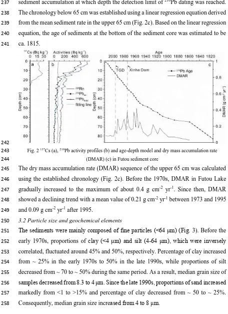
[image:9.595.53.509.75.702.2]242
Fig. 2 137Cs (a), 210Pb activity profiles (b) and age-depth model and dry mass accumulation rate 243
(DMAR) (c) in Futou sediment core 244
The dry mass accumulation rate (DMAR) sequence of the upper 65 cm was calculated 245
using the established chronology (Fig. 2c). Before the 1970s, DMAR in Futou Lake 246
gradually increased to the maximum of about 0.4 g cm-2 yr-1. Since then, DMAR 247
showed a declining trend with a mean value of 0.21 g cm-2 yr-1 between 1973 and 1995 248
and 0.09 g cm-2 yr-1 after 1995. 249
3.2 Particle size and geochemical elements 250
The sediments were mainly composed of fine particles (<64 μm) (Fig. 3). Before the 251
early 1970s, proportions of clay (<4 μm) and silt (4-64 μm), which were inversely 252
correlated, fluctuated around 45% and 50%, respectively. Percentage of clay increased 253
from ~ 25% in the early 1970s to 50% in the late 1990s, while proportions of silt 254
decreased from ~ 70 to ~ 50% during the same period. As a result, median grain size of 255
samples decreased from 8.3 to 4 μm. Since the late 1990s, proportions of sand increased 256
markedly from <1 to >15% and percentage of clay decreased from ~ 50 to ~ 25%. 257
259
Fig. 3Sedimentary profiles of particle size and elements in Futou sediment core (the grey bar indicates 260
the time of dam construction with the depth of the bar accounting for dating error) 261
Three distinctive patterns of changes in elements were observed. Al, Fe, Li, Mg, K and 262
Cr exhibited similar vertical trends (Fig. 3) wherein they fluctuated before 1935, 263
gradually decreased until the late 1990s, followed by a more pronounced decline after 264
1995. In contrast, Sr concentrations increased gradually between 1935 and the early 265
1970s and rapidly from the early 1970s to the late 1990s. Trends in concentrations of 266
Cu, Zn and TP differed from the other elements; concentrations fluctuated before 1935, 267
declined gradually between 1935 and the late 1990s and increased thereafter. After 268
1995, concentrations of Zn and TP increased from ca. 120 and 610 mg kg-1 to more 269
than 140 and 800 mg kg-1, respectively. 270
3.3 PCA of elemental data 271
PCA of elemental geochemistry showed that axis 1 and axis 2 explained 74.3% and 272
14.2% of variance in elemental concentrations, respectively (Fig. 4). The first PCA axis 273
(PC1elements) was negatively correlated with Al, Fe, Mg, K, Cr and Li (R2>0.75, p<0.001) 274
and positively correlated with Sr (R2>0.72, p<0.001). Cu, Zn and TP were positively 275
correlated with axis 2 (PC2elements). Four stages divided by the damming events are 276
distinguished in the ordination plot (analysis of non-parametric statistics, p<0.05) (Fig. 277
4). Before 1935, samples were placed at the left of the ordination plot, and they then 278
shift between the mid-1930s and early 1970s, towards high abundances of Sr. Between 279
[image:10.595.89.506.67.306.2]After 1995, samples sustained high Sr concentrations and low concentrations of Al, Fe, 281
Li, Mg, K and Cr. 282
[image:11.595.178.420.112.347.2]283
Fig. 4 Principle component analysis (PCA) ordination plot of metal elements and TP 284
3.4 Chironomids 285
A total of 42 chironomid species were identified in the sediment core. Chironomid 286
assemblages were dominated by Microchironomus tener-type, Cricotopus sylvestris -287
type, Paratanytarsus penicillatus-type and Paratanytarsus sp., which had an average 288
abundance of ca. 27.9%, 9.7%, 16.8% and 10.7%, respectively (Fig. 5). Over the last 289
200 years, there was a major assemblage shift from M. tener-type to C. sylvestris-type, 290
P. penicillatus-type and Paratanytarsus sp. Before 1935, chironomid assemblages were 291
dominated by M. tener-type (average ca. 38.9%), accompanied by Clinotanypus 292
(average ca. 9.2%) and Procladius (about 5.0%) with few C. sylvestris-type, P. 293
penicillatus-type and Polypedilum nubifer-type. Between 1935 and the early 1970s, the 294
abundance of Paratanytarsus sp., P. penicillatus-type and C. sylvestris-type increased 295
to 7.3%, 3.3% and 12.8%, respectively. The transition period from the early 1970s to 296
1995 was characterized by the decline in M. tener-type (from ≥50 to ≤10%) and 297
increases in C. sylvestris-type (from 3.4 to ca. 15%), Paratanytarsus sp. (from ca. 13 to 298
ca. 23%) and P. penicillatus-type (from ≤15 to ca. 30%). Since 1995, chironomid 299
assemblages were co-dominated by C. sylvestris-type, Paratanytarsus sp. and P. 300
penicillatus-type, with P. penicillatus-type having an average abundance of ≥32% 301
whilst M. tener-type declined to ≤5%. In this zone, Glyptotendipes severini-type, 302
which were present at lower strata (e.g., Clinotanypus, Cryptotendipes, 304
Cryptochironomus and Harnischia) disappeared. 305
306
Fig. 5Sedimentary profile of chironomids in Futou sedimentary core (the grey bar indicates the time of 307
dam construction with the depth of bar accounting for dating error) 308
3.5 Diatoms 309
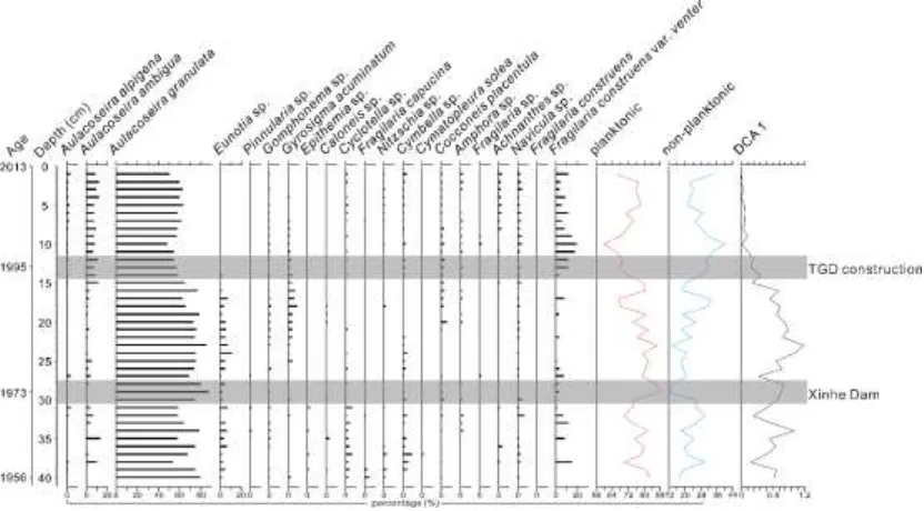
A total of 145 diatom taxa were identified in the sediment core. Diatom assemblages 310
were characterized by planktonic species like Aulacoseira granulata with a few 311
Aulacoseira ambigua, Aulacoseira alpigena, Cyclotella bodanica and Cyclotella. 312
meneghiniana (Fig. 6). Between 1956 and the early 1970s, A. granulata which had an 313
average abundance of over 60% was the dominant species and concentrations of other 314
planktonic taxa such as A. ambigua, A. alpigena and Cyclotella sp. were low. The 315
abundance of epiphytic and benthic diatoms (e.g., Eunotia sp., Cymbella sp., and 316
Navicula sp.) fluctuated around 25%. From the early 1970s to the late 1990s, diatom 317
assemblages were still dominated by planktonic species, especially A. granulata, but 318
the relative abundances started to decline whilst the proportion of epiphytic and benthic 319
diatoms increased (Cocconeis placentula and Gyrosigma acuminatum increased to ca. 320
6% and ≥ 8%, respectively).Since the late 1990s, A. granulata had a percentage of about 321
60% and relative abundances of A. ambigua, A. alpigena and Cyclotella sp. increased 322
compared with the lower strata (for example, the percentage of A. ambigua increased 323
to more than 9%). During this period, concentration of F. construens var. venter 324
[image:12.595.79.507.71.312.2]326
Fig. 6 Sedimentary profiles of diatoms in Futou sedimentary core (the grey bar indicates the time of 327
dam construction with the depth of bar accounting for dating error) 328
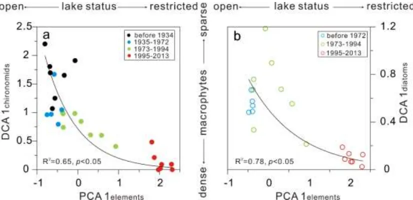
3.6 Relationship between geochemical elements and diatoms and chironomids 329
Comparisons of the PCA1 axis scores from the elements (as indicators of hydrological 330
condition) with biotic assemblages (Fig. 7) demonstrate that diatoms and chironomids 331
responded clearly to dam construction. Chironomid assemblages in Futou Lake were 332
successively characterized by M. tener-type and C. sylvestris-type, P. penicillatus-type 333
and Paratanytarsus sp. In lakes of Europe and the Yangtze floodplain, Paratanytarsus 334
is found in lakes with dense macrophytes (Zhang et al., 2012; Langdon et al., 2010; Cao 335
et al., 2014). C. sylvestris-type which feed on the epiphytes attached to aquatic plants 336
is also associated with macrophytes in Yangtze floodplain lakes (Cao et al., 2014, 2016). 337
The increase of macrophyte-related chironomid species (C. sylvestris-type, P. 338
penicillatus-type and Paratanytarsus sp.) since 1935, and especially after the early 339
1970s, suggested the development of aquatic plants in Futou Lake. An increase of 340
benthic and epiphytic diatoms (e.g., G. acuminatum) further suggest the growth of 341
343
Fig. 7 Scatter plots of first DCA axis of chironomids (a) and diatoms (b) against first PCA axis of 344
elements 345
4 Discussion 346
4.1 Effects of dam constructions on natural hydrology 347
Geochemical compositions of lake sediments provide fruitful information for tracking 348
past changes in hydrological conditions (Rippey et al., 1982; Chen et al., 2016). In 349
closed basin lakes, metal elements mainly come from the erosion of topsoil and bedrock 350
from the lake catchment (Rippey et al., 1982), while sediment influxes from inflows 351
are the main sources of elements in open lakes (Chen et al., 2016). In a river-floodplain 352
system, the main channel is a major source of elements being transported into floodplain 353
lakes (Junk et al., 1989; Chen et al., 2016). The upper reaches of the Yangtze River 354
sequentially cross through the evaporates of the Tibetan Plateau, the Jurassic Red 355
sandstone of the Sichuan Basin and the carbonatite in the Three Gorges Region (Müller 356
et al., 2008). After weathering, large amounts of major elements (e.g., Mg, Al, Fe) are 357
attached on the suspended particles in the Yangtze River and transported into the middle 358
and lower reaches. Once entering the floodplain lakes, these elements are deposit in the 359
lake bottom with the suspended particles (Chen et al., 2016). In contrast, the floodplain 360
in the middle reaches of the Yangtze River is characterized by unconsolidated fluvial 361
deposits with scarce major elements (Müller et al., 2008; Wang et al., 2011). Therefore, 362
it is assumed that variations in sedimentary major elements in Futou Lake should be 363
closely related to the influx from the Yangtze River. Sr which is closely related to Ca, 364
exists as Sr2+ in a dissolved form due to the strong chemical carbonate weathering in 365
the Yangtze Basin and relatively low pH of the waters (Chen et al., 2002). However, 366
sedimentary Sr. PCA1 of elements which strongly correlated with major elements and 368
Sr therefore appears to reflect hydrological connectivity between the lake and the 369
Yangtze River. 370
Under natural hydrological conditions, rainfall is the main factor influencing the water 371
discharge and sediment load in the Yangtze River (Chen et al., 2014), affecting water 372
exchange intensity between the lake and the Yangtze River. In a wet year, high water 373
discharge transports more sediments into the lake while the strong hydrologic flushing 374
decreases Sr concentrations. Conversely, the weak hydrological connection in a dry 375
year decreases the concentration of major elements while increases the concentration 376
of Sr. Hence, the fluctuations of major elements and Sr before 1935 reflected the 377
variation of sediments being transported into Futou Lake under natural hydrological 378
conditions (Fig. 3). 379
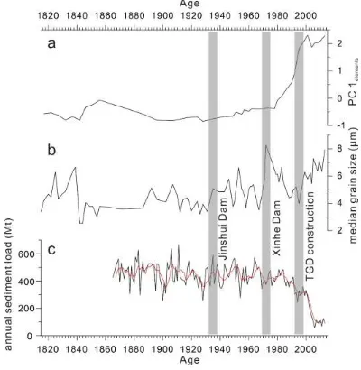
Since 1935, the steady decrease of major elements indicates declining sediments being 380
transported into Futou Lake (Fig. 8a), alongside a longer water retention time 381
(increasing Sr concentrations), associated with impeded interactions between Futou 382
Lake and the Yangtze River, and the stabilization of hydrological conditions due to dam 383
construction. After the Xinhe Dam established in 1973, lower quantities of element-384
enriched sediments from the Upper Yangtze River were transported into Futou Lake, 385
resulting in a further decrease of major elements between the early 1970s and the late 386
1990s (Fig. 8a). The decline of DMAR during this period further reflects the decreasing 387
sediment transport into Futou Lake (Fig. 2c). At the same time, finer particles and Sr 388
were deposited in the lake due to prolonged water retention time, resulting in the 389
decrease of median grain size and the increase of Sr (Fig. 8b). 390
As hydrological conditions in Futou Lake stabilized due to the establishment of local 391
dams, the increase of median grain size reflects an increasing input of coarse particles 392
after the late 1990s. Since the closure of the TGD in 1998, about 150 million tons of 393
sediment enriched in major elements which comes from the upper reaches of the 394
Yangtze River has been trapped in the reservoir (Yang et al., 2014), resulting in a 395
decrease of sediment load in water released from the dam. Observational records from 396
Hankou Hydrological Station show that annual sediment load decreased from 323.12 397
Mt (1991-1998) to 157.57 Mt (1999-2013) (Wang et al., 2008) (Fig. 8c). As a result, 398
DMAR in Futou Lake declined after the closure of the TGD (Fig. 2c). When released 399
from the dam, the sediment-starved water possesses more energy to erode the 400
along the Yangtze River revealed that the main channel between Yichang and Hankou 402
changed from a deposition rate of 78 Mt/yr (1956-2000) to an erosion rate of 47 Mt/yr 403
(2003-2012) and the riverbed sediment which was characterized by primarily medium 404
sized sands prior to the TGD closure is now dominated by gravels (Yang et al., 2014). 405
Therefore the coarsening of particle size and further decreasing of major elements can 406
be attributed to the change of material source from the fine-grained, major element-407
enriched sediments from the upper reaches of the Yangtze River prior to the TGD 408
closure to the coarse-grained, major element-depleted sediments from the downstream 409
riverbed. This suggests that sedimentation and geochemistry in Futou Lake have been 410
influenced by proximal and distal dam structures. 411
[image:16.595.97.497.280.690.2]412
Fig. 8 Comparison between sample score on the first PC axis of elements (a) and median grain size (b) 413
and annual sediment load (the red line indicates five year running average) in Hankou Hydrology 414
Station (cited from Wang et al., 2008) (c) during the last 200 years (the grey bar indicates the time of 415
4.2 Ecological responses to altered hydrology 417
Macrophyte cover, an important structuring component of aquatic ecosystems, may be 418
mediated by water depth, water level fluctuation, light conditions and nutrient 419
concentrations in floodplain lakes (Sokal et al., 2010; Van Geest et al., 2007). 420
Hydrological connectivity with the main channel influences macrophyte growth by 421
changing the light conditions through turbidity and thus closed-drainage lakes generally 422
have high macrophyte densities because of lower suspended sediment concentrations 423
and transparent waters (Sokal et al., 2010; Squires et al., 2002). Conversely, macrophyte 424
cover in open-drainage lakes is usually sparse (Sokal et al., 2010; McGowan et al., 425
2011). Accordingly, macrophyte biomass may vary temporally between flood (low 426
biomass) and non-flood (high biomass) years (Sokal et al., 2010; McGowan et al., 2011). 427
In addition, as shallow lakes are susceptible to sediment resuspension which can 428
enhance water turbidity (Blindow et al., 1993), stable hydrological conditions should 429
prevent erosion of the lake margins and resuspension of sediments, enhancing water 430
transparency and benefiting the development of macrophytes (Egertson et al., 2004). 431
Water level stabilization may also promote the germination and establishment of 432
macrophytes (Van Geest et al., 2005). Since Jinshui Dam established in 1935, the 433
hydrologically open lake changed into a restricted-drainage lake, which probably 434
increased the water transparency. An increase in macrophyte-related chironomid 435
species document the spread of macrophytes at this time. After the impoundment of 436
Xinhe Dam in the early 1970s, light and hydrological conditions became increasingly 437
favorable for macrophytes. Sustained increases of macrophyte-related chironomids and 438
non-planktonic diatoms indicate further expansion of macrophytes cover in Futou Lake, 439
which is coincident with the dense macrophytes cover during this period (Hai Zeng, 440
fisherman on Futou Lake, personal communication, July 30, 2017). Similar biotic 441
responses to reduced hydrological connectivity have been reported in the Yangtze 442
floodplain, Peace-Athabasca Delta, Slave River Delta and lower Rhine floodplain (Liu 443
et al., 2012; McGowan et al., 2011; Sokal et al., 2010; Van Geest et al., 2007). 444
4.3 Increased pollutants since the late 1990s 445
Accompanied with the stabilization of hydrological conditions resulting from dam and 446
levee constructions is a blocked lateral exchange between the lake and the main channel, 447
resulting in a lower water exchange ratio and a prolonged water retention time of 448
floodplain lakes (Chen et al., 2016). For example, after the closure of the TGD, 449
catchment resulted in algal proliferation in Dongting Lake. Since the 1990s, Futou Lake 451
has experienced the intensification of aquaculture with more than 70% of its water area 452
being used for aquaculture in recent years. The increase of TP and Chl a in the water 453
column (Table 1) and declining of macrophytes (Hai Zeng, fisherman on Futou Lake, 454
personal communication, July 30, 2017) since the middle 1990s suggest increased 455
nutrients and habitat disturbance pressures in Futou Lake. Despite the relatively low 456
abundances, frequent occurrence of nutrient-tolerant diatom species (e.g. A. alpigena 457
has an TP optima of about 130 μg L-1 in the Yangtze floodplain lakes) (Yang et al., 458
2008) and chironomid species (e.g. C. plumosus-type, G. severini-type and P. akamusi -459
type) after the late 1990s, together with the sharp increase of Zn and TP concentrations, 460
indicate pollutant enrichment in Futou Lake, which may be attributed to the 461
development of aquaculture and exacerbated sedimentation by hydrological isolation. 462
Even though the high abundance of macorphyte-related chironomids denoted abundant 463
macrophyte cover in Futou Lake, the emergence of nutrient-tolerant chironomid and 464
diatom species indicate initial signs of lake deterioration. We can expect that this 465
hydrologically restricted system may become more and more vulnerable to a state 466
change towards algal dominance and loss of aquatic plants with the continuously 467
development of aquaculture and increase in nutrients (Bhattacharya et al., 2016). Once 468
in a turbid state, there are well known challenges with restoring macrophyte 469
communities unless human disturbance can be restricted to an extremely low level, 470
which is unlikely in this densely populated region (Scheffer et al., 1993; McGowan et 471
al., 2005). 472
4.4 Implications for floodplain lake protection 473
The dominance of macrophyte-related chironomids (C. sylvestris-type, Paratanytarsus 474
sp. and P. penicillatus-type) and high concentrations of non-planktonic diatoms 475
revealed the development of aquatic macrophytes after the establishment of the 476
proximal Jinshui Dam (in 1935) and Xinhe Dam (in the early 1970s) and the distal TGD 477
in the late 1990s. Macrophytes play an important role in buffering shallow freshwater 478
ecosystems against regime shifts into the turbid algae-dominated state (Scheffer et al., 479
2001). Our study provides clear evidence that anthropogenic hydrological regulation 480
which stimulates the growth of macrophytes may buffer against a lake shift into an 481
algae-dominated state caused by eutrophication. Therefore, whilst dam structures 482
undoubtedly alter the ‘natural’ functioning of floodplain lakes, their effects may not be 483
Multiple sedimentary proxies demonstrated by our sediment core suggest that the 485
interactions between increasing nutrients and hydrology both should be considered 486
simultaneously for effective lake management in the future. Because sedimentation in 487
floodplain and shallow lake basins can be spatially variable, further multi-coring studies 488
on Futou Lake and other sites might further understanding of whole lake basin 489
responses, and help to assess how representative single cores are for floodplain lake 490
paleolimnology. Besides, ongoing water monitoring is urgently needed to provide lake 491
ecosystem information for the sustainable management of these important floodplain 492
lakes. 493
Acknowledgements: 494
We are grateful for Xin Mao, Weilan Xia and Yuxin Zhu for field and laboratory 495
assistance. We appreciate Dr. George Swann, Dr. Stefan Engels and Charlotte Briddon 496
from Nottingham University and anonymous reviewers for their constructive comments. 497
This study was supported by the National Natural Science Foundation of China (grant 498
numbers 41572343, 41202248), the Fundamental Research Funds for National 499
University, China University of Geosciences (Wuhan) (grant number G1323511656) 500
and State Key Laboratory of Lake Science and Environment (grant no. 2014SKL002). 501
Linghan Zeng is funded by the Vice-Chancellor’s Scholarship for Research Excellence 502
from University of Nottingham. 503
References: 504
Appleby PG. Chronostratigraphic Techniques in Recent Sediments. In: Last WM, Smol 505
JP, editors. Tracking Environmental Change Using Lake Sediments: Basin Analysis, 506
Coring, and Chronological Techniques. Springer Netherlands, Dordrecht, 2001, pp. 507
171-203. 508
Battarbee RW, Jones VJ, Flower RJ, Cameron NG, Bennion H, Carvalho L, et al. 509
Diatoms. In: Smol JP, Birks HJB, Last WM, Bradley RS, Alverson K, editors. Tracking 510
Environmental Change Using Lake Sediments: Terrestrial, Algal, and Siliceous 511
Indicators. Springer Netherlands, Dordrecht, 2001, pp. 155-202. 512
Bayley PB. Understanding Large River: Floodplain Ecosystems. BioScience 1995; 45: 513
153-158. 514
Bhattacharya R, Hausmann S, Hubeny JB, Gell P, Black JL. Ecological response to 515
hydrological variability and catchment development: Insights from a shallow oxbow 516
lake in Lower Mississippi Valley, Arkansas. Science of the Total Environment 2016; 517
Blindow I, Andersson G, Hargeby A, Johansson S. Long-term pattern of alternative 519
stable states in two shallow eutrophic lakes. Freshwater Biology 1993; 30: 159-167. 520
Brooks SJ, Langdon PG, Heiri O. The identification and use of Palaearctic 521
Chironomidae larvae in palaeoecology: Quaternary Research Association, 2007. 522
Cao Y, Zhang E, Cheng G. A primary study on relationships between subfossil 523
chironomids and the distribution of aquatic macrophytes in three lowland floodplain 524
lakes, China. Aquatic Ecology 2014; 48: 481-492. 525
Cao Y, Zhang E, Tang H, Langdon P, Ning D, Zheng W. Combined effects of nutrients 526
and trace metals on chironomid composition and morphology in a heavily polluted lake 527
in central China since the early 20th century. Hydrobiologia 2016; 779: 147-159. 528
Chen J, Wang F, Xia X, Zhang L. Major element chemistry of the Changjiang (Yangtze 529
River). Chemical Geology 2002; 187: 231-255. 530
Chen J, Wu X, Finlayson BL, Webber M, Wei T, Li M, et al. Variability and trend in 531
the hydrology of the Yangtze River, China: Annual precipitation and runoff. Journal of 532
Hydrology 2014; 513: 403-412. 533
Chen X, McGowan S, Xu L, Zeng L, Yang X. Effects of hydrological regulation and 534
anthropogenic pollutants on Dongting Lake in the Yangtze floodplain. Ecohydrology 535
2016; 9: 315-325. 536
Chen X, McGowan S, Zeng L, Xu L, Yang X. Changes in carbon and nitrogen cycling 537
in a floodplain lake over recent decades linked to littoral expansion, declining riverine 538
influx, and eutrophication. Hydrological Processes 2017; 31: 3110-3121. 539
Chen X, Yang X, Dong X, Liu Q. Nutrient dynamics linked to hydrological condition 540
and anthropogenic nutrient loading in Chaohu Lake (southeast China). Hydrobiologia 541
2011; 661: 223-234. 542
Committee for Lake Records Compilation of Hubei Province. Lake Records 543
Compilation of Hubei Province. Wuhan: Hubei Science & Technology Press, 2014 544
Dong X, Anderson NJ, Yang X, Chen X, Shen J. Carbon burial by shallow lakes on the 545
Yangtze floodplain and its relevance to regional carbon sequestration. Global Change 546
Biology 2012; 18: 2205-2217. 547
Du Y, Xue H, Wu S, Ling F, Xiao F, Wei X. Lake area changes in the middle Yangtze 548
region of China over the 20th century. Journal of Environmental Management 2011; 549
Egertson CJ, Kopaska JA, Downing JA. A Century of Change in Macrophyte 551
Abundance and Composition in Response to Agricultural Eutrophication. 552
Hydrobiologia 2004; 524: 145-156. 553
Fang J, Wang Z, Zhao S, Li Y, Tang Z, Yu D, et al. Biodiversity changes in the lakes 554
of the Central Yangtze. Frontiers in Ecology and the Environment 2006; 4: 369-377. 555
Junk WJ, Bayley PB, Sparks RE. The flood pulse concept in river-floodplain systems. 556
Canadian special publication of fisheries and aquatic sciences 1989; 106: 110-127. 557
Kattel GR, Dong X, Yang X. A century-scale, human-induced ecohydrological 558
evolution of wetlands of two large river basins in Australia (Murray) and China 559
(Yangtze). Hydrology and Earth System Sciences 2016; 20: 2151. 560
Krammer K, Lange-Bertalot H, 1986-1991. Bacillariophyceae. In: Ettl H., Gerloff J, 561
Heynig H, Mollenhauer D, Süßwasserflora von Mitteleuropa. Volume 2 (1-4). Gustav 562
Fischer Verlag, Stuttgart/Jena. 563
Langdon PG, Ruiz Z, Wynne S, Sayer CD, Davidson TA. Ecological influences on 564
larval chironomid communities in shallow lakes: implications for palaeolimnological 565
interpretations. Freshwater Biology 2010; 55: 531-545. 566
Liu E, Yang X, Shen J, Dong X, Zhang E, Wang S. Environmental response to climate 567
and human impact during the last 400 years in Taibai Lake catchment, middle reach of 568
Yangtze River, China. Science of the Total Environment 2007; 385: 196-207. 569
Liu Q, Yang X, Anderson NJ, Liu E, Dong X. Diatom ecological response to altered 570
hydrological forcing of a shallow lake on the Yangtze floodplain, SE China. 571
Ecohydrology 2012; 5: 316-325. 572
McGowan S, Leavitt PR, Hall RI, Anderson NJ, Jeppesen E, Odgaard BV. Controls of 573
algal abundance and community composition during ecosystem state change. Ecology 574
2005; 86: 2200-2211. 575
McGowan S, Leavitt PR, Hall RI, Wolfe BB, Edwards TWD, Karst-Riddoch T, et al. 576
Interdecadal declines in flood frequency increase primary production in lakes of a 577
northern river delta. Global Change Biology 2011; 17: 1212-1224. 578
Müller B, Berg M, Yao ZP, Zhang XF, Wang D, Pfluger A. How polluted is the Yangtze 579
River? Water quality downstream from the Three Gorges Dam. Science of the Total 580
Environment 2008; 402: 232-247. 581
R core team, 2016. R: A language and environment for statistical computing. R 583
Foundation for Statistical Computing, Vienna, Austria. URL https://www.R-584
project.org/. 585
Rieradevall M, Brooks SJ. An identification guide to subfossil Tanypodinae larvae 586
(Insecta: Diptera: Chrironomidae) based on cephalic setation. Journal of 587
Paleolimnology 2001; 25: 81-99. 588
Rippey B, Murphy RJ, Kyle SW. Anthropogenically derived changes in the 589
sedimentary flux of magnesium, chromium, nickel, copper, zinc, mercury, lead, and 590
phosphorus in Lough Neagh, Northern Ireland. Environmental Science & Technology 591
1982; 16: 23-30. 592
Ritchie JC, McHenry JR. Application of radioactive fallout cesium-137 for measuring 593
soil erosion and sediment accumulation rates and patterns: a review. Journal of 594
Environmental Quality 1990; 19: 215-233. 595
Scheffer M, Carpenter S, Foley JA, Folke C, Walker B. Catastrophic shifts in 596
ecosystems. Nature 2001; 413: 591-596. 597
Scheffer M, Hosper SH, Meijer ML, Moss B, Jeppesen E. Alternative equilibria in 598
shallow lakes. Trends in Ecology & Evolution 1993; 8: 275-279. 599
Smith VH, Tilman GD, Nekola JC. Eutrophication: impacts of excess nutrient inputs 600
on freshwater, marine, and terrestrial ecosystems. Environmental Pollution 1999; 1: 601
179-196. 602
Sokal MA, Hall RI, Wolfe BB. The role of flooding on inter-annual and seasonal 603
variability of lake water chemistry, phytoplankton diatom communities and macrophyte 604
biomass in the Slave River Delta (Northwest Territories, Canada). Ecohydrology 2010; 605
3: 41-54. 606
Squires MM, Lesack LFW, Huebert D. The influence of water transparency on the 607
distribution and abundance of macrophytes among lakes of the Mackenzie Delta, 608
Western Canadian Arctic. Freshwater Biology 2002; 47: 2123-2135. 609
Ter Braak CJ, Smilauer P. CANOCO reference manual and CanoDraw for Windows 610
user's guide: software for canonical community ordination (version 4.5). www. canoco. 611
com, 2002. 612
Tockner K, Pusch M, Borchardt D, Lorang MS. Multiple stressors in coupled river– 613
floodplain ecosystems. Freshwater Biology 2010; 55: 135-151. 614
Tockner K, Stanford JA. Riverine flood plains: present state and future trends. 615
Van Geest GJ, Coops H, Roijackers RMM, Buijse AD, Scheffer M. Succession of 617
aquatic vegetation driven by reduced water-level fluctuations in floodplain lakes. 618
Journal of Applied Ecology 2005; 42: 251-260. 619
Van Geest GJ, Coops H, Scheffer M, Van Nes EH. Long Transients near the ghost of a 620
stable state in eutrophic shallow lakes with fluctuating water levels. Ecosystems 2007; 621
10: 37-47. 622
Wang H, Yang Z, Wang Y, Saito Y, Liu JP. Reconstruction of sediment flux from the 623
Changjiang (Yangtze River) to the sea since the 1860s. Journal of Hydrology 2008; 349: 624
318-332. 625
Wang L, Wang Y, Xu C, An Z, Wang S. Analysis and evaluation of the source of heavy 626
metals in water of the River Changjiang. Environmental Monitoring and Assessment 627
2011; 173: 301-313. 628
Wang S, Dou H. Lakes in China. Beijing: Science Press, 1998. 629
Wiederholm T. Chironomidae of the Holarctic region: keys and diagnoses. P. 1, Larvae: 630
Entomologica Scandinavica, 1983. 631
Wolfe BB, Hall RI, Edwards TWD, Johnston JW. Developing temporal 632
hydroecological perspectives to inform stewardship of a northern floodplain landscape 633
subject to multiple stressors: paleolimnological investigations of the Peace–Athabasca 634
Delta. Environmental Reviews 2012; 20: 191-210. 635
Wu Y, Li Y, Lv J, Xi B, Zhang L, Yang T, et al. Influence of sediment DOM on 636
environmental factors in shallow eutrophic lakes in the middle reaches of the Yangtze 637
River in China. Environmental Earth Sciences 2017; 76: 142. 638
Xiang L, Lu XX, Higgitt DL, Wang SM. Recent lake sedimentation in the middle and 639
lower Yangtze basin inferred from 137Cs and 210Pb measurements. Journal of Asia Earth 640
Sciences 2002; 21: 77-86. 641
Yang SL, Milliman JD, Li P, Xu K. 50,000 dams later: Erosion of the Yangtze River 642
and its delta. Global and Planetary Change 2011; 75: 14-20. 643
Yang SL, Milliman JD, Xu KH, Deng B, Zhang XY, Luo XX. Downstream 644
sedimentary and geomorphic impacts of the Three Gorges Dam on the Yangtze River. 645
Earth-Science Reviews 2014; 138: 469-486. 646
Yang X, Anderson NJ, Dong X, Shen JI. Surface sediment diatom assemblages and 647
epilimnetic total phosphorus in large, shallow lakes of the Yangtze floodplain: their 648
relationships and implications for assessing long-term eutrophication. Freshwater 649
Zhang E, Cao Y, Langdon P, Jones R, Yang X, Shen J. Alternate trajectories in historic 651
trophic change from two lakes in the same catchment, Huayang Basin, middle reach of 652