Comparative Analysis of Real-Time Precise
Point Positioning Zenith Total Delay
Estimates
Ahmed, F. (1), Václavovic, P. (2), Teferle, F. N. (1), Douša, J. (2), Bingley, R.(3), Laurichesse, D.(4),
(1) Geophysics Laboratory, University of Luxembourg, Luxembourg
(2) Geodetic Observatory Pecny, Research Institute of Geodesy, Topography and Cartography, Czech Republic
(3) Nottingham Geospatial Institute, University of Nottingham, United Kingdom
(4) Centre National d’Etudes Spatiales, France
+352 661 141010
www.uni.lu
Abstract
over the whole period of the comparison which is a criteria (rather than the magnitude of the bias) for the suitability of ZTD estimates for use in NWP nowcasting. A millimeter-level impact on the ZTD estimates has also been observed in relation to ambiguity resolution.
Keywords:
Introduction
The observations from Global Navigation Satellite Systems (GNSS) can be used to study the state of the troposphere at a given location and time by estimating the respective amount of zenith total delay (ZTD) and converting this to integrated water vapor (IWV) using surface meteorological data (Bevis et al., 1994). Both of these GNSS-derived tropospheric parameters (ZTD and IWV) can further be assimilated into numerical weather prediction (NWP) models having a positive impact on the quality of weather forecasts (Bennitt and Levick, 2011; de Haan, 2011; Gutman et al., 2004; Vedel et al., 2004). As of today, the Global Positioning System (GPS) is the most widely used GNSS in operational meteorology. However, research is on-going for the inclusion of other GNSS in meteorological applications. Therefore, in the following text, the term GNSS would refer to GPS unless otherwise stated.
Over the last decade, a number of international research projects and programmes in Europe (Elgered, 2001; Huang et al., 2003), North America (Smith et al., 2007) and Asia (Iwabuchi et al., 2000) have investigated the use of GNSS-derived near real-time (NRT) ZTD estimates in NWP models. Since 2005, the EUMETNET EIG GNSS water vapor programme (E-GVAP) enables various analysis centers across Europe to submit their NRT ZTD estimates for assimilation into the NWP models of the partner meteorological institutions (Vedel et al., 2012). In late 2012, another European project “COST Action ES1206: Advanced Global Navigation Satellite Systems tropospheric products for monitoring severe weather events and climate (GNSS4SWEC)” (Jones et al., 2012) was approved to investigate GNSS meteorology further in the light of modern challenges and developments.
changes, it is desired to obtain them with a minimal latency of 10 or even 5 minutes while maintaining an accuracy of 5 to 30 mm.
The real-time (RT) transport of GNSS observational data and products is carried in the formats specified by the Special Committee 104 (SC104) of the Radio Technical Commission for Maritime Services (RTCM) (http://www.rtcm.org/, Heo et al., 2009) using the Network Transport of RTCM via Internet Protocol (NTRIP) (Weber et al., 2006). Since December 2012, the Real-Time Service (RTS) of the International GNSS Service (IGS) (Caissy et al., 2012; Dow et al., 2009) and its associated analysis centers are making RT orbit and clock products officially available to the GNSS community. These products include the broadcast ephemeris and the orbit and clock corrections. The IGS together with RTCM-SC104 have defined different formats for the dissemination of observation and correction data in RT. The format for observation data messages is called RTCM-3 and that for orbit and clock correction messages is called RTCM-SSR where SSR stands for State Space Representation (Weber et al., 2012; Wübbena, 2012). The RTCM-SSR real-time streams are composed of various types of messages.
Using the RT data and products, ZTD can be estimated in RT but different strategies result in different accuracies of the obtained ZTD estimates. The availability of orbit and clock products in RT triggers the possibility to perform Precise Point Positioning (PPP) (Zumberge et al., 1997) in RT. Although both the double differenced (DD) and PPP processing strategies can be implemented in RT, PPP is highly suitable for RT processing due to being computationally more efficient.
unit and the estimated vertical position (Fritsche et al., 2005). If the error in ZTD is approximated as one third of the vertical position error (Hill et al., 2009), it would mean that an increase of the TEC unit from 25 to 175 will result in a ZTD error ranging from 0.6 mm to 4 mm if higher-order ionospheric corrections are not applied. Furthermore, errors in the a priori zenith hydrostatic delay (ZHD) caused by the use of inaccurate surface pressure values could result in an error of -0.1 mm/hPa to -0.2 mm/hPa in vertical position estimates (Tregoning and Herring, 2006) and this could also lead to an error in the ZTD. Antenna related errors, e.g. phase center offsets and variations (PCV) and radome geometry, also lead to errors in the vertical position and the ZTD estimates. Byun and Bar-Sever (2009) and Thomas et al. (2011) have shown that differences in the estimated ZTD with and without the PCV corrections may vary from 2 to 10 mm. The tropospheric mapping functions (MF), which are used to map the tropospheric delay from other angles (slant) to zenith, also have an elevation-dependent effect on the corresponding ZTD, although the effect of the MF reduces with an increase in any elevation cut-off angle used for observations (Ning, 2012).
Fixing of integer phase ambiguities enhances the precision of the position estimates. In the DD strategy, common errors are removed and it becomes easier to identify and fix such integer ambiguities. However, for un-differenced observations, it was not possible to fix the integer phase ambiguities until recently (Geng et al., 2010). Amongst others, the Centre National d’Etudes Spatiales (CNES) has developed strategies to fix integer ambiguities of un-differenced phase measurements by first fixing the difference between the ambiguities on the two carrier frequencies and then fixing the remaining ambiguity in a global network solution (Loyer et al., 2012). To date, only few studies have been performed to study the impact of ambiguity resolution on the GNSS-based ZTD estimates and some of them are based on in-house software and products (Shi and Gao, 2012, Li et al., 2014).
RTS as well as from the individual analysis center CNES. The effect of integer ambiguity resolution on ZTD estimates has also been studied. All the software packages and products used are freely available.
The next sections describe the RT-PPP software packages, the RT data and products, and the reference solutions used in this study followed by results, discussion and conclusions.
Real-Time PPP Systems
The real-time processing for a selection of GNSS stations and time periods was simultaneously performed at the University of Luxembourg (UL) and the Geodetic Observatory Pecny (GOP). UL generated the solutions from BNC2.7 and PPP-Wizard whereas GOP generated the solutions using the Tefnut application from their G-Nut software library.
The BKG Ntrip Client (BNC), developed by the Bundesamt für Kartographie und Geodäsie (BKG) (Weber and Mervart, 2012), is capable of performing PPP in RT (PPP). For this study, version 2.7 of the BNC has been used to perform RT-PPP using streams of code plus phase observations, the broadcast ephemeris and corrections for satellite orbits and clocks. During the processing in BNC, the corrections from the RT streams are applied to the broadcast ephemeris. Along with the precise position estimates, the ZTD estimates can also be obtained as one of the outputs. The recent study by Yuan et al (2014) is also based on this software package, however, they have modified it to implement some precise bias models such as ocean tide loading, receiver antenna PCV and computation of hydrostatic and wet mapping functions from Global Pressure and Temperature 2 (GPT2) model (Lagler et al., 2013).
The G-Nut software library (Václavovic et al., 2013) has been developed at the Geodetic Observatory Pecny (GOP) since 2011 in order to support development of high-accuracy GNSS analysis. Several end-user applications have been derived for meteorology and climatology (Tefnut), geodesy and seismology (Geb) and GNSS quality checking (Anubis). We have used the G-Nut/Tefnut software which is capable of estimating GNSS tropospheric parameters in RT, NRT and post-processing modes (Douša and Václavovic, 2014).
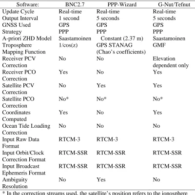
All the above mentioned software packages use the Kalman filter approach. The configuration and characteristics of the software packages used in this study are shown in Table 1. For the BNC2.7 and PPP-Wizard solutions, the a priori coordinates of the stations were computed by a 20-day average of coordinates obtained using PPP with the Bernese GPS Software 5.0 (Dach et al., 2007). The G-Nut/Tefnet does not need a priori coordinates, however, if precise station coordinates are available, they can be introduced into the processing as a priori values. In this campaign, G-Nut/Tefnet was used without introducing a priori coordinates. During the RT data processing, BNC2.7 computed the receiver coordinates (unconstrained) in every epoch whereas the version of PPP-Wizard used for this study did not estimate the receiver coordinates in order to reduce the number of unknown parameters. Hence in the PPP-Wizard solution, the coordinates were fixed to the values provided a priori and the ZTD was estimated every 5 seconds. The G-Nut/Tefnut software applied simultaneous coordinate and ZTD estimations. The former were tightly constrained to remain stable over time while the latter were constrained loosely to optimally balance between stable and reliable tropospheric parameter estimates.
The software packages mentioned here are meant for RT and kinematic applications and therefore do not employ the most precise bias models, e.g. ocean tide loading and higher-order ionospheric corrections, etc.
Real-Time Data and Products
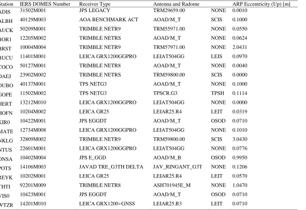
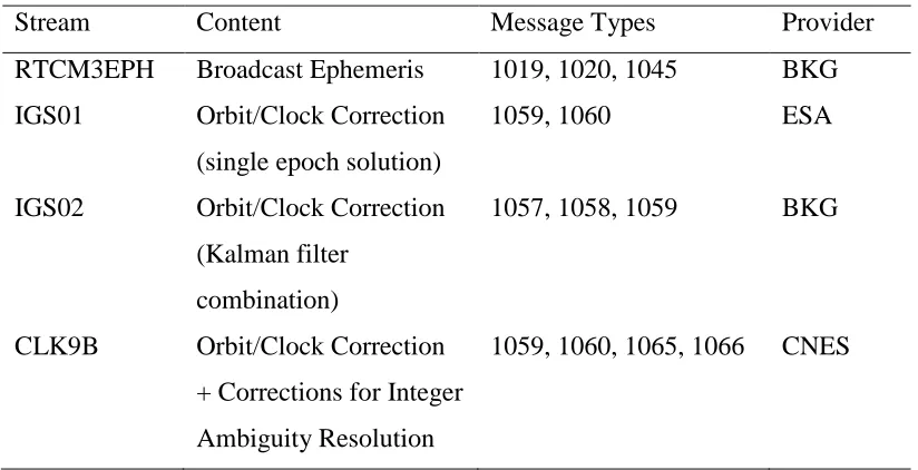
The network of GNSS stations used in this study comprises 22 globally distributed IGS stations which provide RT observation data (Figure 1). Table 2 provides the relevant station information. Only GPS observations have been used in this study. Table 3 provides some characteristics of the RT product streams used for this study.
Reference Datasets
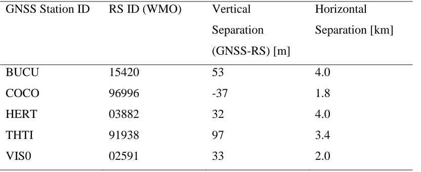
The first reference dataset used to compare the RT-PPP ZTD estimates is the IGS Final Troposphere Product (hereafter termed IGFT) generated by the U.S. Naval Observatory (USNO) (Byram et al., 2011). The IGFT is based on the final IGS orbit and clock products and contains the ZTD estimates computed by processing 27-hour observation window using PPP with the Bernese GPS Software 5.0 at an output sampling interval of 5 minutes. The second reference dataset consists of the ZTD estimates derived from the observations of radiosondes (RS) collocated with 5 selected GNSS stations. The ZHD and ZWD at the RS locations have been corrected for height differences (to the GNSS station height) using the methods described in (Douša and Elias, 2014) and (Gyori and Douša, 2013) respectively. However, no correction has been applied for the horizontal separation between the GNSS station and the collocated RS. Table 4 shows the selection of the RS sites along with their horizontal and vertical distances to the respective GNSS stations. The ZTD from GNSS observations (at the 5 stations shown in Table 4) has then been compared to the ZTD from the corresponding RS.
Results
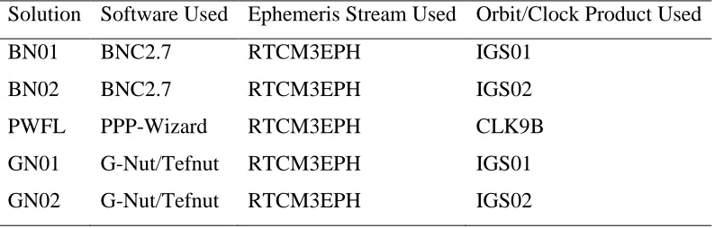
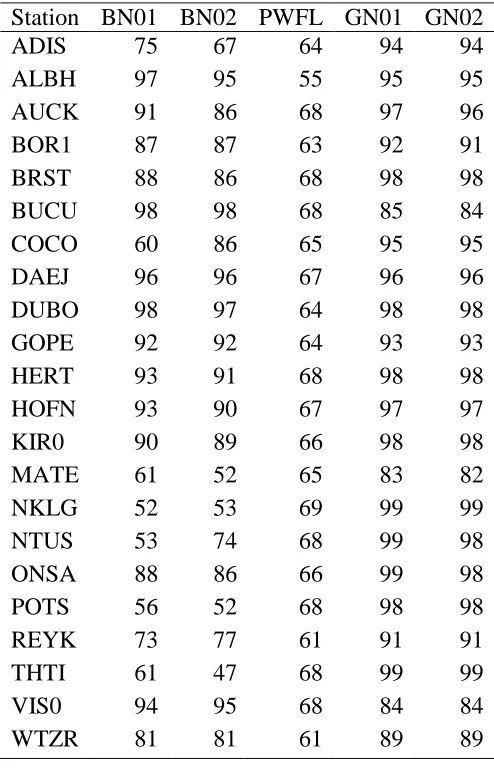
A dataset containing RT-PPP ZTD estimates for the previously described network of stations and a time-period of 31 days (2013-04-18 to 2013-05-18) was obtained using the software packages listed in the previous section. For brevity, we will below refer to the BNC2.7 solutions using the IGS01 products as BN01, the BNC2.7 solutions using the IGS02 products as BN02, the PPP-Wizard (ambiguity float) solutions as PWFL, the G-Nut/Tefnut solutions using IGS01 products as GN01, and the G-Nut/Tefnut solutions using IGS02 products as GN02. Table 5 gives an overview of the product streams and software used in each of the solutions. IGS01 and IGS02 (tested with BNC2.7 and G-Nut/Tefnut) streams contain single-epoch and Kalman filter combined solutions, respectively and could help studying any impact of the combination approaches on the RT-PPP ZTD estimates. Although the PPP-Wizard is also able to ingest the IGS01 and IGS02 product streams in non ambiguity-fixing mode, however, it was tested only with the CLK9B stream in order to examine the impact of ambiguity fixing only by keeping all other parameters in the fixed and float solutions consistent. Various technical problems, often related to data communication, compromise the transfer of real-time data and lead to gaps in the observation data and hence 100% of the data is not available in real-time, which results in gaps in the RT-PPP ZTD time series. Table 6 shows the percentage of ZTD estimates obtained from each of the RT solutions for each station.
On average, the RT-PPP ZTD estimates were available for 78% of the selected time period from BNC27, 65% from PPP-Wizard, and 92% from G-Nut/Tefnut. The lower amount of available RT-PPP ZTD estimates from PPP-Wizard is due to missing data and product streams caused by a temporary network related issue at UL from 2013-05-10 to 2013-05-18. Apart from the missing data, another reason for missing estimates for some epochs is that during the PPP convergence period after a data gap, the ZTD estimates with large formal sigma are rejected.
Internal Evaluation
four stations, and Figure 3 shows the time series of the difference between the RT-PPP ZTD estimates and the IGFT for these stations. The ZTD and difference time series of PWFL solution in Figures 2 and 3 have been plotted after removing the mean bias (considering the fact that the bias in the ZTD is removed before NWP assimilation however, it is important that the bias is stable over time). The gap in the PWFL time series around day 11 for all 4 stations is due to a temporary interruption in the CLK9B product stream. For the station BOR1 (top right), the gap in the time series for all the RT solutions around day 3 is due to interruption of data stream from that station for this period. The gap in the GN01 and GN02 solution for the station BUCU (bottom left) around day 14 is due to an interruption in the data stream at that time at GOP.
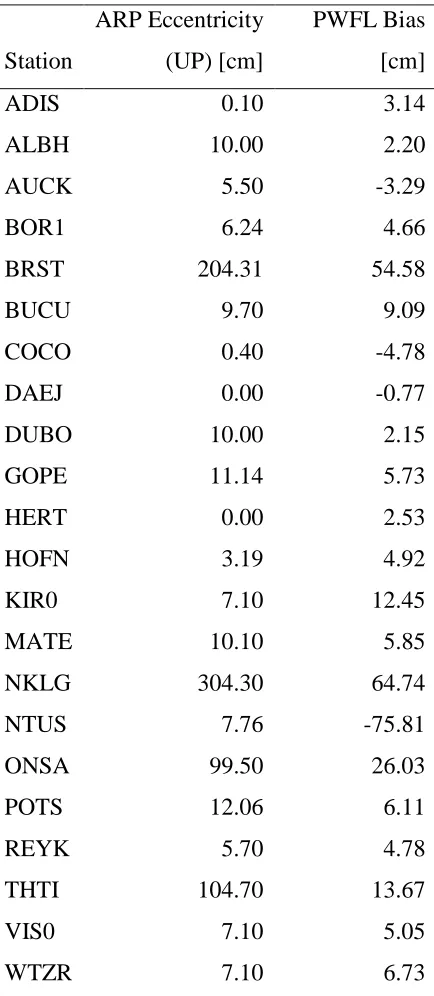
the survey marker and the ZTD estimation at the antenna phase center. Table 8 shows the station-wise biases in PWFL with respect to the up eccentricities of the antenna ARP. However, for the assimilation into NWP models, it can be argued that the standard deviation of the ZTD is of more importance than the bias, because any station-specific biases are corrected for during the screening process before the assimilation. Also, aforementioned mean biases of the RT-PPP ZTD solutions (calculated over all stations) have less significance than that of the standard deviations because the biases vary with location and characteristics of the station.
As mentioned earlier, the PPP-Wizard is capable of resolving integer ambiguities in PPP. In order to study the effect of integer ambiguity resolution on the RT-PPP ZTD estimates, another RT solution for the same stations and time period as above was obtained using PPP-Wizard with the ambiguity resolution feature. We term this solution as PWFX. Keeping in view the time needed for ambiguity
convergence, only those epochs (≈ 40% of the total) from PWFX have been
included in the evaluation for which the number of fixed ambiguities is greater than or equal to 4. The difference between the RT-PPP ZTD of PWFL and PWFX solutions was found to be 0.61 ± 4.66 cm with an RMS of 4.93 cm. The observed impact of ambiguity resolution on ZTD is approximately 6 mm which compares well to, e.g., the 20% (4 to 5 mm) impact observed by Geng et al. (2009). The recent study by Li et al. (2014), which is based on their in-house software and products, also reported on the non-significant differences between the RT-PPP float and fixed solutions after sufficiently long times of convergence, however, it demonstrated the usefulness of ambiguity fixing for the rapid re-initialization of an RT-PPP estimation system (e.g. after an interruption in data stream).
ܲܥܱభାమ=
݂ଵଶܲܥܱభ−݂ଶଶܲܥܱమ
݂ଵଶ−݂ଶଶ
where ݂ଵ= 1575.42ܯ ܪݖ, ݂ଶ= 1227.60ܯ ܪݖ and ܲܥܱ values are in millimeters.
Integer ambiguity fixing was also applied during this experiment. We name the PPP-Wizard solution from this new experiment as PWFX2. The RT-PPP ZTD estimates from PWFX2 were then compared to the corresponding IGFT estimates. The bias between IGFT and PWFX2 was found to be 2.33 ±2.76 cm (in contrast to 6.81 ± 2.42 cm for IGFT−PWFL) with an RMS of 4.60 cm (in contrast to 14.96 cm for IGFT−PWFL). This implies that after applying the ARP eccentricity and PCO corrections to the a priori coordinates, the mean bias between the ZTD estimates from PPP-Wizard and IGFT has been reduced by approximately 66% and the RMS of this bias has been reduced by approximately 70%.
External Evaluation
The statistics from the comparison of GNSS-derived ZTD and RS-based ZTD are summarized in Table 11. In terms of standard deviation, the G-Nut/Tefnut solutions show the best agreement to the RS-based ZTD whereas, in terms of the mean bias, BNC2.7 solutions show the best agreement to the RS-based ZTD. The BNC2.7 solutions show mean biases between 1 to 2 cm, whereas G-Nut/Tefnut and PPP-Wizard solutions show mean biases between 2 to 3 cm with the RS-based ZTD. Figure 4 shows the time series of GNSS-derived and RS-RS-based ZTD estimates for the station HERT as an example. It can be seen that all the time series follow the same pattern and both the GNSS-derived and RS-based ZTD are sensitive to the variations in a similar fashion. This is also the case for the other 4 stations not shown in Figure 4. The time series of the difference between the RT-PPP ZTD solutions and the RS-based ZTD for the station HERT are show in Figure 5.
Discussion
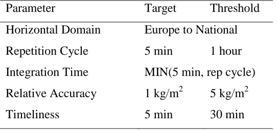
study the potential of ZTD products from ground-based GPS networks for NWP and climate monitoring, specified various user requirements (Offiler, 2010) for GNSS meteorology which define threshold and target values on timeliness, accuracy and resolution etc. of ZTD and IWV estimates for use in NWP nowcasting and climate monitoring. These requirements are widely accepted for quality control during operational use. Table 9 summarizes the current user requirements for NWP nowcasting however, during the new COST Action ES1206 (GNSS4SWEC), these requirements will be revised. The typical value of the dimensionless conversion factor Q (Askne and Nordius, 1987) used for the conversion of Zenith Wet Delay (ZWD) to IWV is approximately 6 and therefore 1 kg/m2of IWV is equivalent to about 6 mm of ZTD (Tomasz et al., 2006). Using this equivalence, the accuracy requirements for IWV can be translated to their equivalent for ZTD which are 6 mm (0.6 cm) target and 30 mm (3 cm) threshold values. Considering the IGFT as the truth and the RMS of the bias of each solution from IGFT as a measure of its relative accuracy, the obtained RT-PPP ZTD solutions can be compared to these requirements. Table 10 shows this comparison for each RT solution generated in this study.
It can be seen from Table 10 that BN02, GN01 and GN02 meet the threshold requirement for relative accuracy whereas BN01 and PWFL exceed the threshold. Although the application of the ARP eccentricity and PCO corrections on the coordinates prior to processing has improved the relative accuracy of the PPP-Wizard solution, it currently exceeds the threshold requirements for NWP nowcasting.
Conclusions
using a single-epoch solution correction stream (IGS01). The ambiguity float solution from the PPP-Wizard has the largest bias to the reference because of the fact that it currently does not apply receiver ARP eccentricity and PCO corrections during processing. However, the application of ARP eccentricity and PCO corrections on the coordinates prior to processing leads to 66% reduction in this bias. Integer ambiguity resolution using the PPP-Wizard seems to have a millimeter-level effect on the RT-PPP ZTD estimates.
The RT-PPP ZTD solutions were compared to the established user requirements for NWP nowcasting by using RMS bias to IGFT as a measure of relative accuracy. It was found that GN01, GN02, and BN02 fulfill the threshold requirements on ZTD accuracy whereas BN01, and PWFL, PWFX (and PWFX2) exceed this threshold. The RT-PPP ZTD solutions were also compared to RS-based ZTD and an agreement of 1 to 3 cm in terms of bias and 1 to 4 cm in terms of standard deviation was found between the two.
Acknowledgements
This project is funded by the Fonds National de la Recherche, Luxembourg (Reference No. 1090247). The work at GOP was funded by the Czech Science Foundation (project No. P209/12/2207). The cooperation was supported by the COST Action ES1206. We are thankful to BKG for the BNC 2.7 software and the EUREF and IGS communities for GNSS data and products.
References
Askne J, Nordius H (1987) Estimation of tropospheric delay for microwaves from surface weather data. Radio Sci 22, 379-86
Benjamin S, Alexander C, Hu M, Dowell D, Weygandt S, James E, Hoffman P, Smirnova T, Brown J, Olson J, Brundage K, Jamison B (2013) Data assimilation and model updates in the 2013 Rapid Refresh (RAP) and High-Resolution Rapid Refresh (HRRR) analysis and forecast systems. NCEP/EMC, MEG Meeting 6 June 2013
Bennitt G, Levick T (2011) The impact of assimilating zenith total delay measurements from ground-based GNSS receivers in the Met Office numerical weather prediction UK model. Geophys Res Abstr Vol. 13, EGU2011-6705
Bevis M, Businger S, Chiswell S, Herring TA, Anthes RA, Rocken C, Ware RH (1994) GPS meteorology: Mapping zenith wet delays onto precipitable water. J Appl Meteorol, 33(3), 379-386
Byram S, Hackman C, Slabinski V, Tracey J (2011) Computation of a high-precision GPS-based troposphere product by the USNO. In: Proc 24thInt Tech Meet Sat Division Inst Nav ION GNSS 2011, Portland, Oregon, USA, 572-578
Byun SH, Bar-Sever YE (2009) A new type of troposphere zenith path delay product of the International GNSS Service. J Geodesy, 83(3-4), 1-7
Caissy M, Agrotis L, Weber G, Hernandez-Pajares M, Hugentobler U (2012) The International GNSS Real-Time Service. GPS World,23 (6), p52
Dach R, Hugentobler U, Fridez P, Meindl M (Eds.) (2007) Bernese GPS Software Version 5.0, 612, Astronomical Institute, University of Bern
De Haan S (2011) Impact of GPS ZTD on rainfall estimates in an hourly update cycle of a numerical weather prediction model. Geophys Res Abstr Vol. 13, EGU2011-4222
Douša J (2012) The impact of errors in predicted GPS orbits on zenith troposphere delay estimation. GPS Solut, 14 (3), 229-239
Douša, J., and M. Elias (2014), An improved model for calculating tropospheric wet delay, Geophys Res Lett, 41, 4389–4397, doi:10.1002/2014GL060271
Douša, J., Vaclavovic, P., Real-time zenith tropospheric delays in support of numerical weather prediction applications, Advances in Space Research, Volume 53, Issue 9, 1 May 2014, Pages 1347-1358, ISSN 0273-1177, http://dx.doi.org/10.1016/j.asr.2014.02.021
Dow JM, Neilan RE, Rizos C (2009) The International GNSS Service in a changing landscape of Global Navigation Satellite Systems. J Geodesy, 83(3-4), 191–198
Elgered G (2001) An overview of COST Action 716: Exploitation of ground-based GPS for climate and numerical weather prediction applications, Phys Chem Earth Pt A, 26(6-8), 399-404
Geng J, Meng X, Dodson AH, Teferle FN (2010) Integer ambiguity resolution in precise point positioning: Method comparison. J Geodesy, 84(9), 569-581
Geng J, Teferle FN, Shi C, Meng X, Dodson AH, Liu J (2009) Ambiguity resolution in precise point positioning with hourly data. GPS Solut, 13 (4), 263-270
Glowacki TJ, Penna NT, Bourke WP (2006) Validation of GPS-based estimates of integrated water vapour for the Australian region and identification of diurnal variability. Aust Met Mag 55 (2006) 131-148
Gutman SI, Sahm SR, Benjamin SG, Schwartz BE, Holub KL, Stewart JQ, Smith TL (2004) Rapid retrieval and assimilation of ground based GPS precipitable water observations at the NOAA Forecast Systems Laboratory: Impact on weather forecasts. J Meteor Soc Japan, 82(1B), 351-360
Gyori, G., Douša, J., 2013. GOP-TropDB development for tropospheric product evaluation and monitoring – design, functionality and initial results. In: Rizos, C., Willis, P. (Eds.), IAG Symposia Series, vol. 143. Springer (accepted for publication)
Heo Y, Yan T, Lim S, Rizos C (2009) International standard GNSS real-time data formats and protocols, IGNSS Symposium 2009, Australia
Hill EM, Davis JL, Elósegui P, Wernicke BP, Malikowski E, Niemi NA (2009) Characterization
of site-specific GPS errors using a short-baseline network of braced monuments at Yucca
Mountain, southern Nevada. J Geophys Res, 114, B11402, doi:10.1029/2008JB006027
Huang XY, Vedel H, Gustafsson N, Ridal M, Jupp A, Offiler D, Eyre J, Navascues B, Garcia-Moya J, Ferretti R, Faccani C, Visconti G, de Haan S, de Vries J, Barlag S, Jarvinen H, Eresmaa R, d’Andon OF, Lesne O, Jiang W, Elgered G, Johansson J, Kristansen O, Kierulf HP, Plag H-P, Vespe F, Pacione R, Rius A, Brockmann E, Douša J, Filler V, van der Marel H (2003) TOUGH: Targeting optimal use of GPS humidity measurements in meteorology, International Workshop on GPS Meteorology, Tsukuba, Japan, 14-17 January 2003
Iwabuchi T, Naito I, Mannoji N (2000) A comparison of Global Positioning System retrieved precipitable water vapor with the numerical weather prediction analysis data over the Japanese Islands. J Geophys Res, 105, 4573-4585 C2000
monitoring. Abstract G11A-0901 presented at 2012 Fall Meeting, AGU, San Francisco, Calif., 3-7 Dec.
Lagler, K, M Schindelegger, J Boehm, H Krásná, and T Nilsson (2013), GPT2: Empirical slant delay model for radio space geodetic techniques, Geophys Res Lett, 40, 1069–1073, doi:10.1002/grl.50288
Laurichesse D (2011) The CNES real-time PPP with undifferenced integer ambiguity resolution demonstrator. In: Proc 24thInt Tech Meet Sat Division Inst Nav ION GNSS 2011, 654-662
Laurichesse D, Mercier F, Berthias JP, Broca P, Cerri, L (2009) Integer Ambiguity Resolution on Undifferenced GPS Phase Measurements and its Application to PPP and Satellite Precise Orbit Determination. Navigation, 56, N° 2, Summer 2009
Li, X., G. Dick, M. Ge, S. Heise, J. Wickert, and M. Bender (2014), Real-time GPS sensing of atmospheric water vapor: Precise point positioning with orbit, clock, and phase delay corrections, Geophys. Res. Lett., 41, doi:10.1002/2013GL058721
Loyer S, Perosanz F, Mercier F, Capdeville H, Marty J-C (2012) Zero-difference GPS ambiguity resolution at CNES–CLS IGS Analysis Center. J Geodesy 86 (11), 991-1003
Ning T (2012) GPS meteorology: With focus on climate applications, PhD Thesis, Chalmers University of Technology, ISBN 978-91-7385-675-1
Offiler D (2010) Product Requirements Document Version 1.0 – 21 December 2010. EIG EUMETNET GNSS Water Vapour Programme (E-GVAP-II)
Shi J, Gao Y (2012) Improvement of PPP-inferred tropospheric estimates by integer ambiguity resolution. Adv Space Res, 50(10), 1374-1382
Smith TL, Benjamin SG, Gutman SI, Sahm SR (2007) Forecast impact from assimilation of GPS-IPW observations into the Rapid Update Cycle. Mon Wea Rev, 135(8), 2914–2930
Thomas ID, King MA, Clarke PJ, Penna NT (2011) Precipitable water vapor estimates from homogeneously reprocessed GPS data: An intertechnique comparison in Antarctica. J Geophys Res, 116, doi:10.1029/2010JD013889
Václavovic P, Douša J, Gyori G (2013) G-Nut software library - State of development and first results. Acta Geodyn Geomat, 10(172) (in print)
Vedel H, de Haan S, Jones J, Offiler D, Bennit G (2012) Status of E-GVAP, EUREF 2012 Symposium
Vedel H, Huang X-Y, Haase J, Ge M, Calais E (2004) Impact of GPS zenith tropospheric delay data on precipitation forecasts in Mediterranean France and Spain. Geophys Res Lett, 31, L02102, doi:10.1029/2003GL017715
Weber G, Dettmering D, Gebhard H (2006) Networked Transport of RTCM via Internet Protocol (NTRIP). International Association of Geodesy Symposia: A window on the Future of Geodesy, Vol. 128
Weber G, Mervart L (2012) BKG Ntrip Client (BNC) Version 2.7 Manual, Federal Agency for Cartography and Geodesy, Frankfurt, Germany
Weber G, Schmitz M, Söhne W, Wübbena G (2012) Data flow and format issues to support a variety of real-time services/applications, IGS Workshop, 22-27 July 2012, Olsztyn, Poland
Wübbena G, (2012) RTCM-SSR Strategy of Bias Treatment, Workshop on GNSS Biases, Bern, January 18-19, 2012
Yuan, Y, K Zhang, W Rohm, S Choy, R Norman, and C-S Wang (2014), Real-time retrieval of precipitable water vapor from GPS precise point positioning, J Geophys Res Atmos, 119, doi:10.1002/2014JD021486
Table 1 Configuration of the software packages used in this study
Software: BNC2.7 PPP-Wizard G-Nut/Tefnut
Update Cycle Real-time Real-time Real-time
Output Interval 1 second 5 seconds 5 seconds
GNSS Used GPS GPS GPS
Strategy PPP PPP PPP
A-priori ZHD Model Saastamoinen Constant (2.37 m) Saastamoinen Troposphere
Mapping Function
1/cos(z) GPS STANAG (Chao’s coefficients)
GMF Receiver PCV
Correction
No No Elevation
dependent only Receiver PCO
Correction
Yes No Yes
Satellite PCV Correction
No Yes Yes
Satellite PCO Correction
No* No* No*
Coordinates Computed
Yes No Yes
Ocean Tide Loading Correction
No No No
Input Raw Data Format
RTCM-3 RTCM-3 RTCM-3
Input Orbit/Clock Correction Format
RTCM-SSR RTCM-SSR RTCM-SSR
Input Broadcast Ephemeris Format
RTCM-SSR RTCM-SSR RTCM-SSR
Ambiguity Resolution
No Yes No
Table 2 Receiver and antenna information for IGS real-time stations used in this study
Station IERS DOMES Number Receiver Type Antenna and Radome ARP Eccentricity (Up) [m]
ADIS 31502M001 JPS LEGACY TRM29659.00 NONE 0.0010
ALBH 40129M003 AOA BENCHMARK ACT AOAD/M_T SCIS 0.1000
AUCK 50209M001 TRIMBLE NETR9 TRM55971.00 NONE 0.0550
BOR1 12205M002 TRIMBLE NETRS AOAD/M_T NONE 0.0624
BRST 10004M004 TRIMBLE NETR9 TRM57971.00 NONE 2.0431
BUCU 11401M001 LEICA GRX1200GGPRO LEIAT504GG LEIS 0.0970
COCO 50127M001 TRIMBLE NETR8 AOAD/M_T NONE 0.0040
DAEJ 23902M002 TRIMBLE NETRS TRM59800.00 SCIS 0.0000
DUBO 40137M001 TPS NETG3 AOAD/M_T NONE 0.1000
GOPE 11502M002 TPS NETG3 TPSCR.G3 TPSH 0.1114
HERT 13212M010 LEICA GRX1200GGPRO LEIAT504GG NONE 0.0000
HOFN 10204M002 LEICA GR25 LEIAR25.R4 LEIT 0.0319
KIR0 10422M001 JPS EGGDT AOAD/M_T OSOD 0.0710
MATE 12734M008 LEICA GRX1200GGPRO LEIAT504GG NONE 0.1010
NKLG 32809M002 TRIMBLE NETR9 TRM59800.00 SCIS 3.0430
NTUS 22601M001 LEICA GRX1200GGPRO LEIAT504GG NONE 0.0776
ONSA 10402M004 JPS E_GGD AOAD/M_B OSOD 0.9950
POTS 14106M003 JAVAD TRE_G3TH DELTA JAV_RINGANT_G3T NONE 0.1206
REYK 10202M001 LEICA GR25 LEIAR25.R4 LEIT 0.0570
THTI 92201M009 TRIMBLE NETR8 ASH701945E_M NONE 1.0470
VIS0 10423M001 JPS EGGDT AOAD/M_T OSOD 0.0710
Table 3 Real-time correction streams (http://rts.igs.org/products/, http://www.ppp-wizard.net/caster.html)
Stream Content Message Types Provider
RTCM3EPH Broadcast Ephemeris 1019, 1020, 1045 BKG IGS01 Orbit/Clock Correction
(single epoch solution)
1059, 1060 ESA
IGS02 Orbit/Clock Correction (Kalman filter
combination)
1057, 1058, 1059 BKG
CLK9B Orbit/Clock Correction + Corrections for Integer Ambiguity Resolution
Table 4 The selected radiosondes used for comparison
GNSS Station ID RS ID (WMO) Vertical Separation (GNSS-RS) [m]
Horizontal Separation [km]
BUCU 15420 53 4.0
COCO 96996 -37 1.8
HERT 03882 32 4.0
THTI 91938 97 3.4
Table 5 Combinations of software package and product streams used in RT-PPP ZTD solutions
Solution Software Used Ephemeris Stream Used Orbit/Clock Product Used
BN01 BNC2.7 RTCM3EPH IGS01
BN02 BNC2.7 RTCM3EPH IGS02
PWFL PPP-Wizard RTCM3EPH CLK9B
GN01 G-Nut/Tefnut RTCM3EPH IGS01
Table 6 Percentage of available RT-PPP ZTD epochs in different solutions
Station BN01 BN02 PWFL GN01 GN02
ADIS 75 67 64 94 94
ALBH 97 95 55 95 95
AUCK 91 86 68 97 96
BOR1 87 87 63 92 91
BRST 88 86 68 98 98
BUCU 98 98 68 85 84
COCO 60 86 65 95 95
DAEJ 96 96 67 96 96
DUBO 98 97 64 98 98
GOPE 92 92 64 93 93
HERT 93 91 68 98 98
HOFN 93 90 67 97 97
KIR0 90 89 66 98 98
MATE 61 52 65 83 82
NKLG 52 53 69 99 99
NTUS 53 74 68 99 98
ONSA 88 86 66 99 98
POTS 56 52 68 98 98
REYK 73 77 61 91 91
THTI 61 47 68 99 99
VIS0 94 95 68 84 84
Table 7 Biases in RT-PPP ZTD solutions to IGFT
Solution Mean [cm] STD [cm] RMS [cm]
BN01 3.17 4.61 6.04
BN02 0.46 2.72 2.92
PWFL 6.81 2.42 14.96
GN01 1.16 0.82 1.43
Table 8 Station-wise mean bias in PWFL and the ARP UP eccentricity
Station
ARP Eccentricity (UP) [cm]
PWFL Bias [cm]
ADIS 0.10 3.14
ALBH 10.00 2.20
AUCK 5.50 -3.29
BOR1 6.24 4.66
BRST 204.31 54.58
BUCU 9.70 9.09
COCO 0.40 -4.78
DAEJ 0.00 -0.77
DUBO 10.00 2.15
GOPE 11.14 5.73
HERT 0.00 2.53
HOFN 3.19 4.92
KIR0 7.10 12.45
MATE 10.10 5.85
NKLG 304.30 64.74
NTUS 7.76 -75.81
ONSA 99.50 26.03
POTS 12.06 6.11
REYK 5.70 4.78
THTI 104.70 13.67
VIS0 7.10 5.05
Table 9 User requirements for GNSS meteorology (NWP nowcasting)
Parameter Target Threshold
Horizontal Domain Europe to National Repetition Cycle 5 min 1 hour Integration Time MIN(5 min, rep cycle) Relative Accuracy 1 kg/m2 5 kg/m2
Table 10 Comparison of RT relative accuracies to user requirements of GNSS meteorology
RT Solution
ZTD relative accuracy
[cm]
Difference from required target
[cm]
Difference from required threshold
[cm]
Remarks
BN01 6.04 5.44 3.04 Exceeds the
threshold
BN02 2.92 2.32 -0.08 Meets the
threshold
PWFL 14.96 14.36 11.96 Exceeds the
threshold
GN01 1.43 0.83 -1.58 Meets the
threshold
GN02 1.38 0.78 -1.62 Meets the
threshold
PWFX2 4.64 4.04 1.64 Exceeds the
Table 11 Statistics of comparison between GNSS-derived and RS-based ZTD
RT-PPP Solution Mean (GNSS-RS) [cm]
STD (GNSS-RS) [cm]
RMS (GNSS-RS) [cm]
BNC (IGS01) 1.40 3.44 4.41
BNC (IGS02) 1.71 3.19 4.30
PPP-Wizard*
(fixed) 2.76 3.12 5.23
Tefnut (IGS01) 2.17 1.32 3.04
Tefnut (IGS02) 2.12 1.29 3.01