http://www.scirp.org/journal/jss ISSN Online: 2327-5960
ISSN Print: 2327-5952
DOI: 10.4236/jss.2018.64025 Apr. 30, 2018 294 Open Journal of Social Sciences
Strengthening of Indonesian Borderland at
South China Sea Water Area (Strategic Study on
Development of Natuna Regency into Province
by Formation Natuna Regency)
Fernandes Simangunsong, Imelda Hutasoit
Institut Pemerintahan Dalam Negeri (Governmental Institute of Home Affairs), Sumedang, Indonesia
Abstract
This study provides an overview of the level of ability of autonomous regions of Natuna Regency-Riau Islands Province on the border of Indonesia, to de-sign the formation of new autonomous regions based on the criteria of re-gional formation referring to GR. 129 of 2000/No. 78 of 2007, and the Draft Government Regulation on Area Arrangement. This study uses the applica-tion of measurement model and evaluaapplica-tion of the ability of a region in the implementation of regional autonomy, so the sample is a saturated sample, where the population consists of 15 districts, 70 villages and 6 sub-urban. This research concludes that the division in Natuna can be designed in 4 alterna-tives that can become its own province, if the Anambas Islands Regency, which is the division of Natuna Regency also plan the establishment of 1 new autonomous region (NAR), so the requirement for the manufacture of special province, South China Sea waters can be achieved because Natuna will be di-vided into 3 (three) autonomous regions while the Anambas Islands District will be divided into 2 (two) autonomous regions. 5 (five) autonomous regions shall be the basic requirement for the establishment of 1 (one) autonomous region at the provincial level.
Keywords
Development of Region, Local Government, Province and Regency, Borders of South China Sea, Public Policy
1. Introduction
Regional reorganization is activities in stewardship, creation, and elimination of
How to cite this paper: Simangunsong, F. and Hutasoit, I. (2018) Strengthening of Indonesian Borderland at South China Sea Water Area (Strategic Study on Develop-ment of Natuna Regency into Province by Formation Natuna Regency). Open Journal of Social Sciences, 6, 294-336.
https://doi.org/10.4236/jss.2018.64025
Received: March 28, 2018 Accepted: April 27, 2018 Published: April 30, 2018
Copyright © 2018 by authors and Scientific Research Publishing Inc. This work is licensed under the Creative Commons Attribution International License (CC BY 4.0).
http://creativecommons.org/licenses/by/4.0/
DOI: 10.4236/jss.2018.64025 295 Open Journal of Social Sciences
region as an integral part of decentralization policy [1]. Scope of regional reor-ganization, thereby, includes formation or creation of region, elimination and merging region(s), adjustment of borders, changing of regional status both ad-ministratively or politically, and relocation of capital city. Indonesia has had policy on regional reorganization. But there are a number of weaknesses as fol-lows:
1) Epistemologically, design of policy is heavily related with inward-looking mindset, thus concept of regional reorganization is merely emphasized on for-mation of region or creation of New Autonomous Region (NAR). And so is the parameter set as requirement for creation of region, either administrative, tech-nical or territorial requirements;
2) It is still partial, in terms of interests per region are still the main focus. This is seen from the implementation of bottom-up planning approach in the procedure for creation of region [2];
3) Implementation of the design is still fragmented by sector, thus regional reorganization is not optimal while government’s burden is increasing [3];
4) To counter these weaknesses, it is required to have more comprehensive, integrative, and global design of reorganization, thereby central government re-vise Law No. 32 of 2004 by Law No. 23 of 2014 on Local Government. With cen-tral government revising GR No. 78 of 2007 in form of Draft Regional Regula-tion (DRR) in lieu of GR No. 78 of 2007 on Regional ReorganizaRegula-tion, there will be a design of regional reorganization that consider all sectors in development, national interests, and opportunities and challenges in globalization era. Thus, regions don’t only attempt to improve their social welfare, but also increase na-tional honor and dignity and become internana-tional oriented [4].
Phenomena of formation of region that widely occurs in whole Indonesia, are also being talked about in the community of Natuna Regency who think that there is partiality in the development due to great extent of area so that span of control for public services is very far and barely felt by some of the community in Natuna Regency, especially community in distant islands who struggle with the difficult natural condition of South China Sea. Geographically, Natuna Re-gency lies between 1˚16'North latitude to 7˚19'North latitude and 105˚00'East longitude and 110˚00'East longitude. Natuna Regency has area size of 264,198.37 km2, consisting mostly of water area, with area of 262,197.07 km2, and the rest is
islands, with area of 2001.3 km2. Population size of Natuna Regency in 2016 is
73.470 people. Natuna Regency is one of 183 regions in Indonesia categorized as UOF (Underdeveloped, Outermost, and Frontmost), where administratively this region shares borders with:
North Side: Vietnam and Cambodia. South Side: Bintan Island.
East Side: East Malaysia and West Kalimantan. West Side: Anambas Islands Regency.
DOI: 10.4236/jss.2018.64025 296 Open Journal of Social Sciences
Island and Serasan Island. These islands are divided into 2 groups:
Natuna Islands, consisting of islands in Bunguran, Sedanau, Midai, Pulau Laut, and Pulau Tiga.
Serasan Islands, consisting of islands in Serasan, Subi Besar, and Subi Kecil
[5].
Climate in Natuna, which is part of Riau Islands Province, is tropical and very susceptible by changes of wind direction. Dry season usually occurs on March to July. Average rainfall is 193.2 millimeters with average humidity of 90.4% and average temperature of 25.8˚C. The exploitation of sea potential is minimum due to there is only six months of friendly season. This has great influence on fishery business in Riau Islands Province, both in fishing and in cultivation. While in the rests, when North Wind comes, the sea around Natuna becomes savage and fishermen prefer to farm for living. Natuna Regency (Figure 1) con-sists of 15 districts, 70 villages and 6 sub-districts, with characteristics of islands area and very far span of control between some districts to capital of regency causing great difficulty for administration of government, especially in providing excellent public services [6].
Aspiration of Natuna community expecting formation/creation of new auto-nomous region needs to be responded by authorized parties, mainly Local Gov-ernment and Regional House of Representatives (DPRD). This is in line with ex-planation of Law No. 23 of 2014 on Local Government that implementation of regional autonomy should always be oriented to improvement of social welfare by considering public interests and aspiration. The question is whether this as-piration can assure the improvement of public services and social welfare in Na-tuna Regency.
It can only be answered objectively if firstly there is study on existing poten-tials and problems in Natuna, and then followed by exploring public aspiration and opinion through direct interview and questionnaire. Formation of Natuna Regency should be carried out if it impacts positively on better and more evenly distribution of development and public services.
DOI: 10.4236/jss.2018.64025 297 Open Journal of Social Sciences Figure 1. Map of administrative area of natuna regency. (Source: natuna regency in number 2015).
And then, in Law No. 32 of 2004 in lieu of Law No. 22 of 2000, it regulates creation of region and special territory. As explanation of those laws and regula-tions, government has issued Government Regulation No. 78 of 2007 on Crea-tion, Elimination and Merging of Regions in lieu of Government Regulation No. 129 of 2000. According to it, requirements for creation of autonomous region should at least qualify administrative, technical and territorial physical re-quirements. Administrative requirement for province includes approval by DPRD of regencies/cities and regents/mayors in the area of proposed province, approval by DPRD of parent province and the governor, and also recommenda-tion from Minister of Home Affairs. For crearecommenda-tion of autonomous region of gency/city, it includes approval by DPRD of regencies/cities, approval by re-gents/mayors, approval by governor, approval by DPRD of province, and rec-ommendation from governor.
DOI: 10.4236/jss.2018.64025 298 Open Journal of Social Sciences
after reaching minimum age of governmental administration, of which for province is 10 years and for regency/city is 7 years [8].
Furthermore, for now Government has issued Law No. 23 of 2014 in lieu of Law No. 32 of 2004 on Local Government, and also in awaiting for approval of Draft Government Regulation (DGR) on Regional Reorganization in lieu of GR No. 78 of 2007. In Law No. 23 of 2014 and DGR on Regional Reorganization, it is stated that formation of region is included in context of regional reorganiza-tion consisting of Creareorganiza-tion of Region and Readjustment of Region based on consideration of NATIONAL STRATEGIC INTERESTS. Furthermore, it is also explained that Creation of Region takes form of formation of region and merging of regions. Formation of region can take form of dividing of province or regency/city into two or more new regions or merging of regions or adjacent division of regions within 1 (one) province into one new region. Formation of region is implemented through phase of Preparation Region of Province or Preparation Region Regency/City by qualifying basic and administrative requirements, and for creation of Preparation region of city, in addition to qualifying basic and administrative requirements, it should also has urban characteristic of 50% (fifty percent) or more of its population working out-side primary sectors. Basic requirement for creation of preparation region of aforementioned includes:
A) Territorial basic requirement, including: a) Minimum area size;
b) Minimum population size; c) Territorial borders; d) Territorial coverage; and
e) Minimum age of province, regency/city, and district.
Territorial basic requirement is regulated in more detail in Regulation of Mi-nister Regulation, which differentiate requirements of minimum area size and population size according to grouping of island or islands defined by territorial borders with coordinates in basic map. In general, territorial coverage for crea-tion of region includes:
a) At least 5 (five) regencies/cities for creation of province; b) At least 5 (five) districts for creation of regency; and c) At least 4 (four) districts for creation of city.
It also differentiates territorial coverage of preparation region consisting of islands of which territorial coverage should detail name of islands. In addition to territorial coverage, creation of autonomous region should also comply with regulation of minimum age of governmental administration, including:
a) Minimum age of province is 10 (ten) years and regency/city is 7 (seven) years, from the date of the creation; and
b) Minimum age of district under territorial coverage of regency/city is 5 (five) years, from the date of the creation [9].
B) Basic requirements of Regional capacity
DOI: 10.4236/jss.2018.64025 299 Open Journal of Social Sciences
1) Geography, including: a) Location of capital; b) Hydrographic; and c) Disaster-proneness. 2) Demograhy, including: a) Quality of human resources; and b) Distribution of population. 3) Security, including: a) General criminal acts; and b) Social conflicts.
4) Social-politics, local custom, and traditions, including: a) Public participation in general election;
b) Social cohesiveness; and c) Social organization.
5) Economic potential, including: a) Economic growth; and
b) Regional core competence. 6) Regional financial, including:
a) Capacity of parent region’s local own source revenue;
b) Potential of proposed preparation region’s local own source revenue; and c) Regional financial and asset management.
7) Capability of governmental administration, including: a) Accessibility of basic service of education;
b) Accessibility of basic service of health;
c) Accessibility of basic service of infrastructures; d) Number of state civil apparatus in parent region; and e) Draft spatial planning for preparation region.
Based on elaboration above, Natuna Regency will implement regional reor-ganization by creation of new autonomous region (formation of region), how-ever, it is required to firstly study its regional potential, by measurement and evaluation of variables or criteria of regional potential to determine whether it is possible or not to create new autonomous region in Natuna Regency according to criteria stated in GR No. 129 of 2000 derivative of Law No. 22 of 1999, GR No. 78 of 2007 derivative of Law No. 32 of 2004, and DGR on Regional Reorganiza-tion derivative of Law No. 23 of 2014 [10].
2. Problem Statement
DOI: 10.4236/jss.2018.64025 300 Open Journal of Social Sciences
of Natuna Regency can be formulated as follows:
1) What is description on capability level of Natuna Regency in the adminis-tration of local government?
2) How is design of possibility on the creation of new autonomous region based on criteria of formation of region serving as basis in determining the recommended policy of whether or not it is possible to create new autonomous region in Natuna Regency, with reference to GR No. 129 of 2000, GR No. 78 of 2007, and DGR on Regional Reorganization 2016?
3. Theoretical Framework
Theoretical framework on creation of new autonomous region in this paper is carried out with criteria:
a) According to Law No. 22 of 1999 and GR No. 129 of 2000
Taking close look on Chapter III of Law No. 22 of 1999, it appears that in or-der to exploit capability of the region to implement regional autonomy, it is possible to make policy at the same level of law for creation, formation, elimina-tion and merging of autonomous regions. Correspondingly, policy rule of Gov-ernment Regulation No. 129 of 2000 have also been issued, in which regulates the requirement for creation and criteria of formation, elimination and merging of regions [11]. In Article 11 and Article 15 of said GR, it also regulates on pro-cedure for measurement and evaluation of creation, formation, elimination and merging of regions. Measurement and evaluation are conducted towards capa-bility level of the region, represented as indicators and sub-indicators of va-riables/criteria of economic capability, regional potential, socio-culture, so-cio-politics, population size, area size and other considerations that may enable the implementation of regional autonomy. Result of measurement is particular total score of capability level of potential which serve as basis for evaluation of whether a region is adequate or not for formation. Evaluation on the capability level of region for formation is evaluation on potential of all districts to have de-scription on the capability of proposed autonomous city and proposed parent regency [12].
Result of evaluation can be categorized into 3 (three) levels, Qualified, Quali-fied with Condition and UnqualiQuali-fied, which serve as recommendation for pol-icy:
1) If proposed autonomous city is qualified and proposed parent regency is qualified, then action to be taken is to recommend the formation of autonomous region/creation of new autonomous city;
DOI: 10.4236/jss.2018.64025 301 Open Journal of Social Sciences
3) If both are or any of proposed autonomous city and proposed parent re-gency is unqualified, then action to be taken is to conduct promotion and de-velopment of potential to become categorized as qualified with condition [10].
For more detailed theoretical framework for creation of autonomous city in Natuna Regency, see chart below (Figure 2).
b) According to Law No. 32 of 2004 and GR No. 78 of 2007
Taking close look Law No. 32 of 2004, Chapter III on Creation of Region and Special Region, especially Article 4 clause (1), it appears that in order to exploit capability of the region to implement regional autonomy, it is possible to make policy at the same level of law for creation, formation, elimination and merging of autonomous regions [13]. Policy on guideline that regulate requirement for creation, elimination and merging of region is stated in Government Regulation No. 78 of 2007 Measurement and evaluation are conducted towards capability level of the region, represented as indicators and sub-indicators of factors of demography, economic capability, regional potential, financial capability, so-cio-culture, socio-politics, area size, security and defense, welfare rates and span of control [14].
Result of measurement is particular total score of capability level of region which serve as basis for evaluation of whether a region is adequate or not for formation. Evaluation of capability level of region for formation is evaluation towards potential of district. Result of evaluation can be categorized into 5 (five) levels: Very Capable, Capable, Less Capable, Incapable and Very Incapable. Result of evaluation serves as recommendation for policy as follows:
1) A region is recommended as autonomous region if parent region and pro-posed formed region have total score under category of very capable (420 - 500) or capable (340 - 419), and total score for factors of demography by 80 - 100, economic capability by 60 - 75, regional potential by 60 - 75 and financial capa-bility by 60 - 75.
2) Recommendation for creation of region is declined if parent region or proposed formed region have total score under category of less capable, incapa-ble, and very incapable to administer regional autonomy, or total score for fac-tors of demography by less than 80, economic capability by less than 60, regional potential by less than 60, or financial capability by less than 60 [10].
For more detailed theoretical framework for formation of Natuna Regency according to GR No. 78 of 2007, see chart below (Figure 3).
c) According to Law No. 23 of 2014, and DGR on Regional Reorganiza-tion 2017
DOI: 10.4236/jss.2018.64025 302 Open Journal of Social Sciences Figure 2. Theoretical framework for creation of new autonomous region of natuna regency (GR No. 129 of 2000).
Figure 3. Theoretical framework for creation of new autonomous region of natuna regency (GR No. 78 of 2007).
to preserve uniqueness of local custom, tradition, and culture, and to find solu-tion for social conflicts [16].
Creation of province and regency/city can be by Formation of Region and Merging of Regions. Formation of region can take form of dividing of province or regency/city into two or more new regions or merging of regions or adjacent division of regions 1 (one) new region. Creation of Region is preceded by Prep-aration Region stage in 3 (three) years. Creation of PrepPrep-aration Region should qualify 2 (two) requirements: a) basic requirement; and b) administrative quirement. Basic requirements include territorial basic requirements and re-gional capacity basic requirements [17].
Preparation Region is headed by Head of Preparation Region appointed from qualified civil servant. Preparation Region receives administrative and financial
Measurement of
Potential Creation of Autonomous Design of Possibility for to Qualify Criteria City
Evaluation of Potential
7 Variables of Study
Result of Evaluation
1. Economic capability 2. Regional Potential 3. Socio-Culture 4. Socio-Politics 5. Population Size 6. Area Size 7. Other Considerations
Level of Capability ofNatuna Regency Riau
Islands Province
Alternative 1
Alternative 2
Alternative 3
Qualified 2,950 ≤TS <4,380
Qualified with Condition 1,833 ≤TS <2,950
Unqualified 715 ≤TS <1,833
Creation of Autonomous Regency Formation of Autonomous Regency followed by improvement of potential within certain period of
time Development of
potential into category of Qualified
with Condition Proposed City &
Proposed Parent Regency 1
Proposed City & Proposed Parent
Regency 3 Proposed City & Proposed Parent
Regency 2
Measurement of
Potential Design of Possibility for Creation of to Qualify Criteria
Autonomous City
Evaluation of Potential
7 Variables of Study
Result of Evaluation
1. Economic capability 2. Regional Potential 3. Socio-Culture 4. Socio-Politics 5. Population Size 6. Area Size 7. Other Considerations
Level of Capability ofNatuna Regency Riau
Islands Province
Alternative 1
Alternative 2
Alternative 3
Qualified 2,950 ≤TS <4,380
Qualified with Condition 1,833 ≤TS <2,950
Unqualified 715 ≤TS <1,833
Creation of Autonomous Regency Formation of Autonomous Regency followed by improvement of potential within certain period of
time Development of
potential into category of Qualified
with Condition Proposed City &
Proposed Parent Regency 1
DOI: 10.4236/jss.2018.64025 303 Open Journal of Social Sciences
affairs in order to administer government. Central Government provides ste-wardship and supervision towards Preparation Region in preparation period. Supervision towards Preparation Region is also conducted by DPRD and Re-gional Representatives Council (DPD) and community. Towards Preparation Region, evaluation in the first and second year as well as final evaluation are conducted. Final evaluation is conducted in preparation period at least 3 (three) months before the end of 3 (three) years preparation period. If result final evalu-ation shows that the Preparevalu-ation Region is unqualified, its status is returned to Parent region. If the Preparation Region is qualified, then it shall be formed as Region by Law [18].
Merging of Regions can be by merging of 2 (two) or more adjacent regen-cies/cities in 1 (one) province into new regency/city, and merging of 2 (two) or more adjacent provinces into new province. Merging of regions is conducted based on agreement of concerned regions or result of evaluation by Central Government. Merging of Regions based on agreement of concerned regions should qualify administrative requirements and regional capacity basic require-ments. It can also be conducted in case of one or several regions is/are unable to administer regional autonomy based on result of evaluation of Central Govern-ment. For Regional Reorganization, Central Government can also conduct Readjustment of Region. Readjustment of region can be by change of regional borders, name change of region, naming of and name change of earth surface, relocation of capital, and/or name change of capital. Change of regional borders is regulated by Law. Name change of region, naming of and name change of earth surface, relocation of capital, and name change of capital city are regulated by Government Regulation.
Creation of region can also be conducted by Central Government with con-sideration of national strategic interests, which applies to borderlands, outer-most islands, and certain regions for maintaining of interests and sovereignty of the Unitary State of the Republic of Indonesia. Creation of Region with consid-eration of national strategic interests should have territorial coverage with clear borders and should consider parameter of security and defense, economic po-tential, and other parameter that consolidate sovereignty of the Unitary State of the Republic of Indonesia. Creation of Region with consideration of national strategic interests should also be conducted through phase of Preparation Region of province or regency/city for at least 5 (five) years period.
ad-DOI: 10.4236/jss.2018.64025 304 Open Journal of Social Sciences
minister regional autonomy, so that the purpose of Regional Reorganization can be achieved [10].
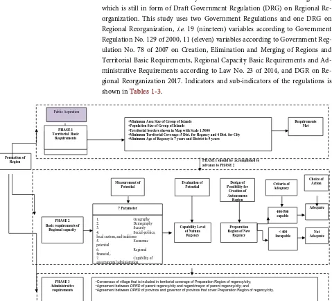
For more detailed theoretical framework for formation of Natuna Regency according to DGR on Regional Reorganization 2017 as follow-up of Law No. 23 of 2014, see chart below (Figure 4).
4. Research Method
Population of local government organization in this study is all districts in Na-tuna Regency or 15 (fifteen) districts and 70 villages and 6 sub-villages. This study was made not long after the enactment of Law No. 23 of 2014 on Local Government in lieu of Law No. 32 of 2004 on Local Government, by which enactment should be followed by the issuance of new Government Regulation, which is still in form of Draft Government Regulation (DRG) on Regional Re-organization. This study uses two Government Regulations and one DRG on Regional Reorganization, i.e. 19 (nineteen) variables according to Government Regulation No. 129 of 2000, 11 (eleven) variables according to Government Reg-ulation No. 78 of 2007 on Creation, Elimination and Merging of Regions and Territorial Basic Requirements, Regional Capacity Basic Requirements and Ad-ministrative Requirements according to Law No. 23 of 2014, and DGR on Re-gional Reorganization 2017. Indicators and sub-indicators of the regulations is shown in Tables 1-3.
[image:11.595.60.539.249.683.2]
Figure 4. Theoretical framework for creation of new autonomous region of natuna regency (Law No. 23 of 2014, and DGR on Regional Reorganization 2017).
PHASE 1 Territorial Basic
Requirements
•Minimum Area Size of Group of Islands •Population Size of Group of Islands
•Territorial borders shown in Map with Scale 1:5000
•Minimum Territorial Coverage: 5 Dist. for Regency and 4 Dist. for City •Minimum Age of Regency is 7 years and District is 5 years
Requirements Met
PHASE 2 Basic requirements of
Regional capacity Measurement of Potential 7 Parameter Evaluation of Potential Capability Level of Natuna Regency Design of Possibility for Creation of Autonomous Region Preparation Region of New
Regency Criteria of Adequacy 400-500 capable < 400 Incapable Choice of Action Adequate Not Adequate Formation of Region
1. Geography
2. Demography
3. Security
4. Social-politics, local custom, and traditions
5. Economic
potential
6. Regional
financial,.
7. Capability of
governmental administration,
PHASE 1 should be accomplished to advance to PHASE 2
Public Aspiration
PHASE 3 Administrative
requirements
•Consensus of village that is included in territorial coverage of Preparation Region of regency/city; •Agreement between DPRD of parent regency/city and regent/mayor of parent regency/city; and
•Agreement between DPRD of province and governor of province that cover Preparation Region of regency/city. PHASE 1
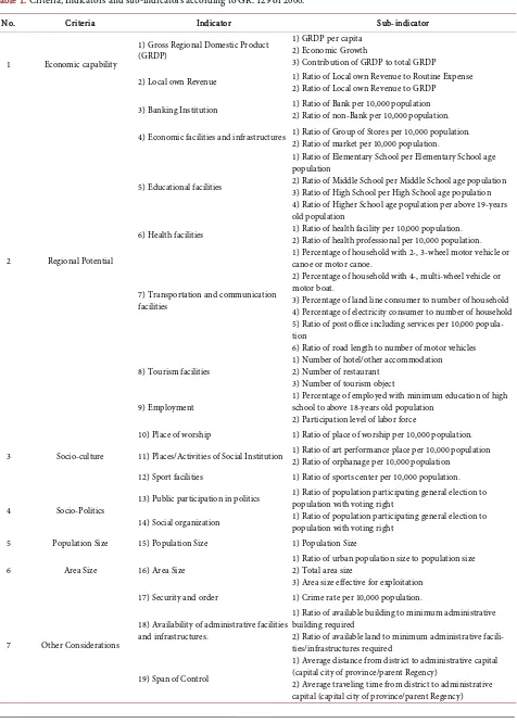
DOI: 10.4236/jss.2018.64025 305 Open Journal of Social Sciences Table 1. Criteria, Indicators and sub-indicators according to GR. 129 of 2000.
No. Criteria Indicator Sub-indicator
1 Economic capability
1) Gross Regional Domestic Product (GRDP)
1) GRDP per capita 2) Economic Growth
3) Contribution of GRDP to total GRDP
2) Local own Revenue 1) Ratio of Local own Revenue to Routine Expense 2) Ratio of Local own Revenue to GRDP
2 Regional Potential
3) Banking Institution 1) Ratio of Bank per 10,000 population 2) Ratio of non-Bank per 10,000 population.
4) Economic facilities and infrastructures 1) Ratio of Group of Stores per 10,000 population. 2) Ratio of market per 10,000 population.
5) Educational facilities
1) Ratio of Elementary School per Elementary School age population
2) Ratio of Middle School per Middle School age population 3) Ratio of High School per High School age population 4) Ratio of Higher School age population per above 19-years old population
6) Health facilities 1) Ratio of health facility per 10,000 population. 2) Ratio of health professional per 10,000 population.
7) Transportation and communication facilities
1) Percentage of household with 2-, 3-wheel motor vehicle or canoe or motor canoe.
2) Percentage of household with 4-, multi-wheel vehicle or motor boat.
3) Percentage of land line consumer to number of household 4) Percentage of electricity consumer to number of household 5) Ratio of post office including services per 10,000 popula-tion
6) Ratio of road length to number of motor vehicles
8) Tourism facilities 1) Number of hotel/other accommodation 2) Number of restaurant 3) Number of tourism object
9) Employment
1) Percentage of employed with minimum education of high school to above 18-years old population
2) Participation level of labor force
3 Socio-culture
10) Place of worship 1) Ratio of place of worship per 10,000 population.
11) Places/Activities of Social Institution 1) Ratio of art performance place per 10,000 population 2) Ratio of orphanage per 10,000 population
12) Sport facilities 1) Ratio of sports center per 10,000 population.
4 Socio-Politics 13) Public participation in politics
1) Ratio of population participating general election to population with voting right
14) Social organization 1) Ratio of population participating general election to population with voting right
5 Population Size 15) Population Size 1) Population Size
6 Area Size 16) Area Size
1) Ratio of urban population size to population size 2) Total area size
3) Area size effective for exploitation
7 Other Considerations
17) Security and order 1) Crime rate per 10,000 population.
18) Availability of administrative facilities and infrastructures.
1) Ratio of available building to minimum administrative building required
2) Ratio of available land to minimum administrative facili-ties/infrastructures required
19) Span of Control
1) Average distance from district to administrative capital (capital city of province/parent Regency)
DOI: 10.4236/jss.2018.64025 306 Open Journal of Social Sciences Table 2. Indicators and sub-indicators according to GR. 78 of 2007.
No. FACTORS AND INDICATORS
1. Demography: 1) Population Size 2) Density
2. Economic capability
1) GRDP of Non-oil and gas per capita 2) Economic Growth
3) Contribution of GRDP of Non-oil and gas 3. Regional Potential
1) Ratio of Banking and Non-banking Institution per 10,000 population 2) Ratio of Group of Stores per 10,000 population
3) Ratio of market per 10,000 population
4) Ratio of Elementary School per Elementary School age population 5) Ratio of Middle School per Middle School age population 6) Ratio of High School per High School age population 7) Ratio of health facility per 10,000 population 8) Ratio of health professional per 10,000 population
9) Percentage of household with motor vehicle or canoe or motor canoe or motor boat 10) Percentage of electricity consumer to number of household
11) Ratio of road length to number of motor vehicles
12) Percentage of employed with minimum education of high school to above 18-years old population 13) Number of employed population
14) Ratio of Civil servant to population 4. Financial Capability
1) Number of PDS
2) Ratio of PDS to population size 3) Ratio of PDS to GRDP 5. Socio-culture
1) Ratio of place of worship per 10,000 population 2) Ratio of sports center per 10,000 population 3) Number of Meeting Hall
6. Socio-Politics
1) Ratio of population participating legislative election to population with voting right 2) Number of social organization
7. Area Size 1) Total area size
2) Area size effective for exploitation 8. Defense
DOI: 10.4236/jss.2018.64025 307 Open Journal of Social Sciences Continued
9. Security
1) Ratio of number of Security personnel to area size 10 Social welfare rate
1) Human Development Index 11 Span of Control
[image:14.595.75.536.221.739.2]1) Average distance from district to administrative capital 2) Average travelling time from district to administrative capital
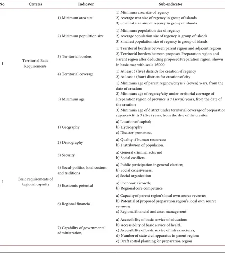
Table 3. Criteria, Indicators and sub-indicators according to GR No. 23 of 2014 and DGR on regional reorganization.
No. Criteria Indicator Sub-indicator
1 Territorial Basic Requirements
1) Minimum area size 1) Minimum area size of regency 2) Average area size of regency in group of islands 3) Smallest area size of regency in group of islands
2) Minimum population size
1) Minimum population size of regency
2) Average population size of regency in group of islands 3) Smallest population size of regency in group of islands
3) Territorial borders
1) Territorial borders between parent region and adjacent regions 2) Territorial borders between proposed Preparation region and Parent region after deducting proposed Preparation region, shown in basic map with scale 1:5000
4) Territorial coverage 1) At least 5 (five) districts for creation of regency 2) At least 4 (four) districts for creation of city
5) Minimum age
1) Minimum age of parent regency/city is 7 (seven) years, from the date of creation;
2) Minimum age of regency/city under territorial coverage of Preparation region of province is 7 (seven) years, from the date of the creation;
3) Minimum age of district under territorial coverage of preparation regency/city is 5 (five) years, from the date of the creation
2 Basic requirements of Regional capacity
1) Geography
a) Location of capital; b) Hydrography c) Disaster-proneness.
2) Demography a) Quality of human resources; b) Distribution of population.
3) Security a) General criminal acts; and b) Social conflicts.
4) Social-politics, local custom, and traditions
a) Public participation in general election; b) Social cohesiveness;
c) Social organization
5) Economic potential a) Economic Growth; b) Regional core competence
6) Regional financial
a) Capacity of parent region’s local own source revenue; b) Potential of proposed preparation region’s local own source revenue;
c) Regional financial and asset management
7) Capability of governmental administration,
DOI: 10.4236/jss.2018.64025 308 Open Journal of Social Sciences Continued
3 Administrative requirements
1) Consensus of village that is included in territorial coverage of Preparation Region of regency/city;
Minutes of Agreement, at least containing:
a) Agreement for Territorial coverage of Preparation region of regency/city;
b) Agreement on name of Preparation region of regency/city; c) Agreement on proposed capital city of Preparation region
2) Agreement between DPRD of parent regency/city and regent/mayor of parent regency/city;
Minutes of agreement between DPRD of parent regency/city and regent/mayor of parent regency/city, at least containing: a) Creation of Preparation region of regency/city;
b) Territorial coverage of Preparation region of regency/city; c) Name of Preparation region of regency/city;
d) Location of capital of Preparation region of regency by showing district appointed as location of capital and stating its coordinates as shown in map attached;
e) Financial support from parent regency/city in the government administration of Preparation region of regency/city for 3 (three) years period, straight from the date of Preparation region is officially announced; and
f) Providing the personnel, facilities and infrastructures, and documents needed by Preparation region
3) Agreement between DPRD of province and governor of province that cover Preparation Region of regency/city.
Minutes of agreement signed by Speaker of DPRD of province and governor of province that cover Preparation Region of regency/city, at least containing:
a) Creation of Preparation region of regency/city;
b) Territorial coverage of Preparation region of regency/city; c) Name of Preparation region of regency/city;
d) Location of capital of Preparation region of regency by showing district appointed as location of capital and stating its coordinates as shown in map attached;
e) Grant for government administration of Preparation region of regency/city for 3 (three) years period, from the date of Preparation region is officially announced
a) Technique of Data Processing according to GR No. 129 of 2000
Category of evaluation is based on particular scale and determined according to classification of qualified, qualified with condition, and unqualified based on representative particular total score, by which category of evaluation serves as basis to choose whether or not to implement formation of autonomous region and exploitation of regional potential. Evaluation method used is scoring system with 3 (three) method types as follows:
Method A (Method of Mean)
Method that compare value of each district towards average value of all dis-tricts. The closer it is to weighted average value of parent region in general, the greater the score is. Each sub-indicator has the lowest score of 1 and highest score of 6. Method A is used for sub-indicator 1, 2 and 3. For scoring, the steps are:
1) Define average score of sub-indicators of all districts;
2) Define score index of sub-indicators in each district (divide score of sub-indicators of each district with average score of all districts and multiplied with 100) and;
DOI: 10.4236/jss.2018.64025 309 Open Journal of Social Sciences
above average (≥100), and score 1 to 4 is score below average {(100-lowest score) divided with 4}.
Method B (Method of Distribution).
Method of average that consider data distribution. Score calculation with this method is adjusted according to skewness and kurtosis of data distribution curve. Each sub-indicator has the lowest score of 1 and highest score of 6. Method B is used for sub-indicator 4 to 24 and 36 to 43. For scoring, the steps are:
1) Calculate the mean, standard deviation, and coefficient of kurtosis;
2) Calculate limit 3 (value 3 × kurtosis × standard deviation), and limit 2 (value 2 × kurtosis × standard deviation) and limit 1 (value 1 × kurtosis × stan-dard deviation) and;
3) Determine index class for scoring:
If indicator value > mean + limit 2, the score is 6;
If mean + limit 2 ≤ indicator value < mean + limit 1, the score is 5; If mean + limit 1 ≤ indicator value < mean, the score is 4;
If mean ≤ indicator value < mean − limit 1, the score is 3;
If mean − limit 1 ≤ indicator value < mean − limit 2, the score is 2;
If indicator value ≤ mean − limit 2, the score is 1.
Method C (Method of Quota)
Method that uses certain number for scoring. The closer it is to number of quota, the higher the score. This method is used for data on population size and only for urban area. Metode C is used for sub-indicator 35. For scoring, the steps are:
1) Determine size of the quota for sub-indicator of population size with as-sumption of 10,000 people;
2) Define index class for scoring with assumption that score 5 to 6 are score above average (≥10,000 people), and score 1 to 4 is score below average {(10,000 people -lowest score) divided with 4}.
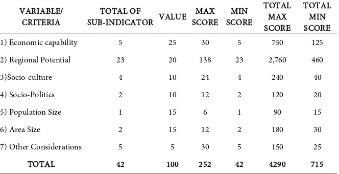
Assumption used in valuing is that every variable or criteria has distinctive value according to its role in the administration of regional autonomy in regen-cy/city. Value for economic capability is 25, regional potential is 20, so-cio-culture is 10, socio-politics is 10, population size is 15, area size is 15, and other considerations is 5. Thus total of all values is 100. Minimum passing score is accumulated score of sub-indicators in each variable/group of criteria multip-lied by score above average for each variable or group of criteria multipmultip-lied by value for each group of indicators. Calculation of minimum and maximum total score of each and every variable can be seen in Table 4 as follows.
DOI: 10.4236/jss.2018.64025 310 Open Journal of Social Sciences Table 4. Maximum and minimum score of variables/criteria.
VARIABLE/ CRITERIA
TOTAL OF
SUB-INDICATOR VALUE MAX SCORE
MIN SCORE
TOTAL MAX SCORE
TOTAL MIN SCORE
1) Economic capability 5 25 30 5 750 125
2) Regional Potential 23 20 138 23 2,760 460
3)Socio-culture 4 10 24 4 240 40
4) Socio-Politics 2 10 12 2 120 20
5) Population Size 1 15 6 1 90 15
6) Area Size 2 15 12 2 180 30
7) Other Considerations 5 5 30 5 150 25
TOTAL 42 100 252 42 4290 715
Table 5. Variable/criteria above average according to GR No. 129 of 2000.
No. Variable/Criteria Calculation Score Above Average
1. Economic capability 3 × 5 × 25 = 375 2 × 4 × 25 = 200 = 575
2. Regional Potential 23 × 4 × 20 = 1.840
3. Socio-culture 4 × 4 × 10 = 160
4. Socio-Politics 2 × 4 × 10 = 80
5. Population Size 1 × 5 × 15 = 75
6. Area Size 2 × 4 × 15 = 180
7. Other Considerations 5 × 4 × 5 = 100
TOTAL = 2.950
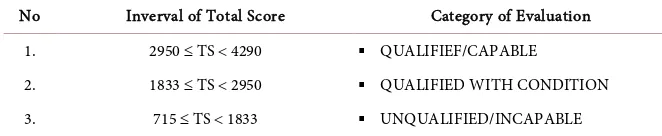
According to Table 5, the score above average is 2950. This means that a regency, either proposed parent regency and proposed formed regency, is de-clared qualified or capable to administer autonomy if the measurement result in score equal to or greater than 2950. On that basis, category of evaluation to-wards regional capability can be defined as stated in Table 6.
As comparison, measurement and evaluation are also conducted by ma-nual/guidelines for creation, formation, elimination and merging of autonomous regions (GR129/2000) which results from cooperation between State Minister of Regional Autonomy, Statistics Indonesia (BPS), National Development Planning Agency (Bappenas), Department of Finance and Department of Home Affairs. Assumption used in this manual is that score above average for each variable is 3, except 3 sub-indicators of variable of economic capability and variable of population size which is 4. For more detail, see Table 7.
[image:17.595.210.539.294.462.2]DOI: 10.4236/jss.2018.64025 311 Open Journal of Social Sciences Table 6. Category and action taken.
No Inverval of Total Score Category of Evaluation 1. 2950 ≤ TS < 4290 QUALIFIEF/CAPABLE
2. 1833 ≤ TS < 2950 QUALIFIED WITH CONDITION 3. 715 ≤ TS < 1833 UNQUALIFIED/INCAPABLE
Table 7. Variable/criteria above average according dept of finance, bappenas, bps, and dept of home affairs.
No Variable/Criteria Calculation Score Above Average
1. Economic capability 3 × 4 × 25 = 300 2 × 3× 25 = 150 = 450
2. Regional Potential 23 × 3 × 20 = 1380
3. Socio-culture 4 × 3 × 10 = 120
4. Socio-Politics 2 × 3 × 10 = 60
5. Population Size 1 × 4 × 15 = 60
6. Area Size 2 × 3 × 15 = 90
7. Other Considerations 5 × 3 × 5 = 75
TOTAL = 2235
less than 2235. To be clear, all calculations and statistic analysis in this paper are aided by computer with program SPSS for MS Windows Release 10.01, Mi-crosoft Excel and Mikrostatistik.
b) 3.5.2 Technique of Data Processing according to GR No. 78 of 2007 Qualitative data is analyzed by content and depth approach to interpret phenomena of demography, economic capability, regional potential, financial capability, socio-culture, socio-politics, area size, security and defense, and span of control. How to accommodate the qualitative analysis is by stimulating vari-ous inclination of qualitative responses from respondents on those phenomena.
From list of open-end structured questions, complemented with compilation of in-depth interviews and field observation, the variables are compiled into structured file. However, some of the qualitative data are renovated into quan-titative data through non-parametric process.
As for quantitative data, it is categorized, classified and processed as basis for measurement and analysis to provide explanation and evaluation on the strengths and weaknesses of variables of economic capability, regional potential, socio-culture, population size, area size, and other considerations in order to encourage regional capability in administration of regional autonomy.
[image:18.595.211.540.203.364.2]DOI: 10.4236/jss.2018.64025 312 Open Journal of Social Sciences
Evaluation method used is scoring system with 2 (two) method types as fol-lows:
Method 1 (Method of Mean)
It is a method that compare value of each proposed region and parent region towards average value of all regions around. The higher the value of proposed region and parent region (if formed) towards average value, the higher the score is. Method 1 is used to calculate value of indicators 2 to 28 and 30 to 34.
Method 2 (Method of Quota)
It is a method that uses certain number as quota for scoring proposed region and parent region. Method 2 is specifically used for indicator 1, population size.
Each indicator has score with scale 1 - 5, average comparing value and amount of quota as basis for scoring. Score 5 is given if value of the indicator is equal to or greater than average value, score 4 is given if value of the indicator is equal to or greater than 80% of average value, score 3 is given if value of the in-dicator is equal to or greater than 60% of average value, score 2 is given if value of the indicator is equal to or greater than 40% of average value, score 1 is given if value of the indicator is equal to or greater than 20% of average value.
Scoring for creation of province uses Comparing Province, creation of regen-cy uses Comparing Regenregen-cy, and creation of city uses Comparing City. Com-paring Regency is regencies in the concerned province, and ComCom-paring City is the similar cities (excluding the capital city of province) in the concerned prov-ince or provprov-ince around it of at least 3 (three) cities. In terms of determining the comparing province, comparing regency and comparing city, provinces, regen-cies and cities that have very different indicator value (above 5 times of the low-est value), the values should be disregarded.
Especially for indicator of territorial characteristic (no. 31), scoring is based on characteristics shown in physical terrain of the proposed autonomous region (lands, or land and coast/sea, or islands, and position of whether or not the pro-posed autonomous region shares borders with other countries).
Scoring for indicator of territorial characteristic is measured with criteria as follows (Table 8).
Assumption used in valuing is that every factor and indicator of criteria has distinctive value according to its role in the creation of regional autonomy.
Minimum passing score is accumulated score of indicators in each factor of criteria multiplied by score above average for each variable or group of criteria multiplied by value for each group of indicators. Passing is determined by total score of factor with category (Table 9).
DOI: 10.4236/jss.2018.64025 313 Open Journal of Social Sciences Table 8. Criteria and score for territorial characteristic.
No. Criteria Score
[image:20.595.200.535.200.739.2]1. Sharing borders with other countries, terrain in form of islands 5 2. Sharing borders with other countries, terrain in form of lands and coasts 4 3. Sharing borders with other countries, terrain in form of lands 3 4. Not sharing borders with other countries, terrain in form of lands and coasts, 2
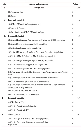
Table 9. Valuing according to GR. No. 78 of 2007.
No. Factors and Indicators Value
1. Demography: 20
1) Population Size 15
2) Density 5
2. Economic capability 15
3) GRDP of Non-oil and gas per capita 5
4) Economic Growth 5
5) Contribution of GRDP of Non-oil and gas 5
3. Regional Potential 15
6) Ratio of Banking and Non-banking Institution per 10,000 population 2 7) Ratio of Group of Stores per 10,000 population 1 8) Ratio of market per 10,000 population 1 9) Ratio of Elementary School per Elementary School age population 1 10) Ratio of Middle School per Middle School age population 1 11) Ratio of High School per High School age population 1 12) Ratio of health facility per 10,000 population 1 13) Ratio of health professional per 10,000 population 1 14) Percentage of household with motor vehicle/canoe/motor canoe/motor
boat 1
15) Percentage of electricity consumer to number of household 1 16) Ratio of road length to number of motor vehicles 1 17) Percentage of employed with minimum education of high school to
above 18-years old population 1
18) Number of employed population 1
19) Ratio of Civil servant to population 1
4. Financial Capability 15
20) Number of PDS 5
21) Ratio of PDS to population size 5
22) Ratio of PDS to GRDP 5
5. Socio-culture 5
23) Ratio of place of worship per 10.000 population 2 24) Ratio of sports facilities per 10,000 population
DOI: 10.4236/jss.2018.64025 314 Open Journal of Social Sciences Continued
25) Number of Meeting Hall 1
6. Socio-Politics 5
26) Ratio of population participating in legislative election to population
with voting right 3
27) Number of social organization 2
7. Area Size 5
28)Total area size 2
29) Area size effective for exploitation 3
8. Defense 5
30) Ratio of number of defense personnel to area size 3 31) Territorial characteristics, from perspective of defense 2
9. Security 5
32) Ratio of number of Security personnel to area size 5
10 Social welfare rate 5
33) Human Development Index 5
11 Span of Control 5
34) Average distance from district to administrative capital 2 35) Average traveling time from district to administrative capital 3
[image:21.595.208.541.410.503.2]Total 100
Table 10. Category of evaluation.
Category Score Explanation
1) Very Capable 420 to 500 Recommendation
2) Capable 340 to 419 Recommendation
3) Less Capable 260 to 339 Declined
4) Incapable 180 to 259 Declined
5) Very Incapable 100 to 179 Declined
or total score for factors of demography by less than 80, economic capability by less than 60, regional potential by less than 60, or financial capability by less than 60. To be clear, all calculations and statistic analysis in this paper are aided by computer with program Microsoft Excel and Microstat.
c) Technique of Data Processing according to Law No. 23 of 2014 and DGR on Regional Reorganization
Technique of data processing according to Law No. 23 of 2014 and DGR on Regional Reorganization can be elaborated as follows:
1) Territorial Basic Requirements
A) Minimum area size of proposed regency and proposed city
Minimum area size for creation of proposed Preparation region of regency is calculated with formula below:
2
+
= XLDP LDPK
DOI: 10.4236/jss.2018.64025 315 Open Journal of Social Sciences
Explanation
LWM = Minimum area size of regency.
XLDP = Average area size of regency in group of islands.
LDPK = Smallest area size of regency in group of islands.
Minimum area size for creation of proposed Preparation region of City is cal-culated with formula below:
2
+
= XLDP LDPK
LWM
Explanation
LWM = minimum area size of city.
XLDP = Average area size of City in group of islands.
LDPK = smallest area size of city
B) Minimum area size of proposed regency and proposed city
Minimum area size for creation of proposed Preparation region of regency is calculated with formula below:
2
+
= XJPP JPPK
JPM
Explanation
JPM = Minimum population size of regency.
XJPP = Average population size of regency in group of islands.
JPPK = Smallest population size of regency in group of islands.
Minimum area size for creation of proposed Preparation region of City is cal-culated with formula below:
2
+
= XJPP JPPK
JPM
Explanation
JPM = minimum population size of city.
XJPP = Average population size of city in group of islands.
JPPK = Smallest population size of city in group of islands C) Territorial borders
a) Territorial borders between parent region and adjacent regions;
b) Territorial borders between proposed Preparation region and Parent region after deducting proposed Preparation region, shown by coordinates in basic map with scale 1:5000 and/or high resolution satellite image with spatial resolution of at least 4 (four) meters.
D) Territorial coverage
Territorial coverage of Preparation region includes: a) At least 5 (five) districts for creation of regency; and b) At least 4 (four) districts for creation of city. Shown in:
a) Map of parent region’s territorial
b) Map of Preparation region’s territorial; and
Prepara-DOI: 10.4236/jss.2018.64025 316 Open Journal of Social Sciences
tion region’s territorial. E) Minimum age
Minimum ages of province, regency/city, and district, as mentioned in Article 6 clause (2) point e:
a) Minimum age of parent province is 10 (seven) years, from the date of crea-tion;
b) Minimum age of parent regency/city is 7 (seven) years, from the date of creation;
c) Minimum age of regency/city under territorial coverage of Preparation re-gion of province is 7 (seven) years, from the date of the creation;
d) Minimum age of district under territorial coverage of preparation regen-cy/city is 5 (five) years, from the date of the creation
2) Basic requirements of Regional capacity
Evaluation of basic requirements of Regional capacity serves as basis for mak-ing decision on adequacy of a proposed Preparation region in terms of meetmak-ing the basic requirements of Regional capacity. Basic requirements of Regional ca-pacity consists of several parameters, each parameter consists of 1 (one) or more indicator(s), and each indicator consists of 1 (one) or more sub-indicator(s). Parameter is main condition that serves as basis in evaluation of basic require-ments of regional capacity. Parameter of basic requirerequire-ments of regional capacity consists of:
1) Parameter of geography; 2) Parameter of demography; 3) Parameter of defense;
4) Parameter of social-politics, local custom, and traditions; 5) Parameter of economic potential;
6) Parameter of regional financial; and
7) Parameter of capability in governmental administration.
Each parameter consists of 1 (one) or more indicator(s). Indicator is a condi-tion that is considered to be able to provide descripcondi-tion on parameter more spe-cifically. Each indicator is elaborated into sub-indicators. Sub-indicator is 1 (one) or more measurement(s) that is/are considered to be able to provide description more particularly on an indicator, either by data or fact from field. Sub-indicator should meet requirements as follows:
1) Data is available; 2) Calculable; 3) Relevant; 4) Measurable; and 5) Reliable.
DOI: 10.4236/jss.2018.64025 317 Open Journal of Social Sciences
a) Maintain objectiveness;
b) Standardize way of evaluation; and c) Facilitate calculation.
In scoring each sub-indicator, it should be preceded by defining range of score from 1 (one) to 5 (five), with 1 (one) as the lowest score and 5 (five) as the high-est score. For most of sub-indicators, score 5 (five) indicates the maximum, bhigh-est, or most expected condition, and score 1 (one) indicates the minimum, worst, or least expected condition. For sub-indicator of accessibility to basic service of education, health, and infrastructures, score 5 (five) indicates the minimum, worst or least expected condition. And score 1 (one0 indicates an already maxi-mum, best, or most expected condition. Score for each sub-indicator is shown as follows (Table 11).
Each sub-indicator has specific value. Value of each sub-indicator is distinc-tive according to its reladistinc-tive importance to indicator or parameter of basic re-quirements of Regional capacity. Sub-indicator that is considered to have rela-tively higher importance have greater value, and sub-indicator that is considered to have relatively lower importance have smaller value. Total score is accumula-tion of all Scores of Sub-indicators. To obtain total score, all Scores of Sub-indicators are accumulated. Criteria of adequacy to qualify basic require-ments of Regional capacity is determined by categories as follows (Table 12).
Explanation:
A proposed Preparation region is declared adequate if having total score of 400 to 500 with category of capable. A proposed Preparation region is declared inadequate if having total score below 400 with category of incapable.
5. Result
Based on analysis of potential of districts in Natuna regency as elaborated in previous Chapter by 2 (two) analyses, i.e. According to GR No. 78 of 2007 with 11 (eleven) variables and GR No. 129 of 2000 with 19 (nineteen) variables and, it can be concluded that:
Result of Analysis of Potential of Natuna Regency according to GR No. 78 of 2007, there are 4 (four) alternatives for creation of new autonomous region in Natuna regency as shown in table below (Table 13).
Based on calculation above (Table 14), it can be explained that:
DOI: 10.4236/jss.2018.64025 318 Open Journal of Social Sciences Table 11. Calculation of regional capacity.
Indicator Sub-indicator Score of Sub-indicator
1) Location of capital
1) Ratio of imbalance of distance between nearest and farthest border of the territorial coverage of proposed Preparation region and proposed capital city.
0.00 - 0.20 = 1 0.21 - 0.40 = 2 0.41 - 0.60 = 3 0.61 - 0.80 = 4 0.81 - 1.00 = 5
2) Availability of land used for administrative capital of proposed Preparation region proven with minutes of submission in the presence of notary.
a) Province (ha): <80 = 1 81 - 90 = 2 91 - 100 = 3 101 - 110 = 4 >110 = 5 b) Regency (ha): <30 = 1 31 - 40 = 2 41 - 50 = 3 51 - 60 = 4 >60 = 5 c) City (ha): <20 = 1 21 - 30 = 2 31 - 40 = 3 41 - 50 = 4 >50 = 5
2) Hydrography
1) Potential of surface water and groundwater in the territorial coverage of proposed Preparation region with classification and criteria of high, medium, or low.
Very high = 5 High = 4 Medium = 3 Low = 2 Very low = 1
2) Availability of raw water for daily needs of population and for economic activities in territorial coverage of proposed Preparation region.
≤10% = 1 10.1% - 20% = 2 20.1% - 30% = 3 30.1% - 40% = 4 >40% = 5
3) Disaster-proneness.
1) Number of types of disaster potential measured by Indonesia Disaster Risk Index (IDRI)
High = 1 Medium = 3 Low = 5
2) Number of natural disaster events in the last 10 (ten) years in the territorial coverage of proposed Preparation Region.
a) Province
Disaster < 5 times = 5 Disaster 5 - 9 times = 4 Disaster 10 - 14 times = 3 Disaster 15 - 19 times = 2 Disaster ≥ 20 times = 1 b) Regency
Without disaster = 5 Disaster ≤5 times = 4 Disaster 6 - 10 times = 3 Disaster 11 - 15 times = 2 Disaster > 15 times = 1 c) City
DOI: 10.4236/jss.2018.64025 319 Open Journal of Social Sciences Continued
4) Quality of human resources
1) Ratio of schooling years rate in territorial coverage of proposed Preparation region to mean years of schooling based on grouping of lands or islands.
≥1.00 = 5 0.90 - 0.99 = 4 0.80 - 0.89 = 3 0.70 - 0.79 = 2 <0.70 = 1
2) Ratio of Gross Enrollment Rate (GER) for high school education in territorial coverage of proposed Preparation Region to average GER based on grouping of lands or islands.
≥1.00 = 5 0.90 - 0.99 = 4 0.80 - 0.89 = 3 0.70 - 0.79 = 2 <0.70 = 1
3) Ratio of GER for elementary school education in territorial coverage of proposed Preparation Region to average GER based on grouping of lands or islands.
≥1.00 = 5 0.90 - 0.99 = 4 0.80 - 0.89 = 3 0.70 - 0.79 = 2 <0.70 = 1
5) Distribution of population. Ratio of population density in territorial coverage of proposed Preparation Region to average population density based on grouping of lands or islands.
≥1.00 = 5 0.90 - 0.99 = 4 0.80 - 0.89 = 3 0.70 - 0.79 = 2 <0.70 = 1
6) General criminal acts
Ratio of general crime rate per 10,000 population in territorial coverage of proposed Preparation region to average general crime rate per 10,000 population based on grouping of lands or islands.
≥1.00 = 1 0.90 - 0.99 = 2 0.80 - 0.89 = 3 0.70 - 0.79 = 4 <0.70 = 5
7) Social conflicts. Number of social conflicts in territorial coverage of proposed Preparation region.
a) Province
Conflict < 5 times = 5 Conflict 5 - 9 times = 4 Conflict 10 - 14 times = 3 Conflict 15 - 19 times = 2 Conflict ≥ 20 times = 1 b) Regency
Without conflict = 5 Conflict ≤5 times = 4 Conflict 6 - 10 times = 3 Conflict 11 - 15 times = 2 Conflict >15 times = 1 c) City
Conflict ≤2 times = 5 Conflict 3 - 5 times = 4 Conflict 6 - 8 times = 3 Conflict 9 - 11 times = 2 Conflict ≥12 times = 1
8) Public participation in general election
Percentage of population participating in general election to population with voting right in territorial coverage of proposed Preparation region.
>70% = 5 60% - 70% = 4 50% - 59% = 3 40% - 49% = 2 <40% = 1
9) Social cohesiveness Number of ethnics/sub-ethnics in territorial coverage of pro-posed Preparation region.
DOI: 10.4236/jss.2018.64025 320 Open Journal of Social Sciences Continued
10) Social organization Number of social organization registered according to laws in territorial coverage of proposed Preparation region.
>40 Social organizations = 5 31 - 40 Social organizations = 4 21 - 30 Social organizations = 3 11 - 20 Social organizations = 2 <10 Social organizations = 1
11) Economic Growth
1) Ratio of average economic growth for 5 (five) years in territorial coverage of proposed Preparation region to average economic growth based on grouping of lands or islands for 5 (five) years.
≥1.00 = 5 0.90 - 0.99 = 4 0.80 - 0.89 = 3 0.70 - 0.79 = 2 <0.70 = 1
2) Ratio of population density in territorial coverage of proposed Preparation Region to average population density based on grouping of lands or islands.
≥1.00 = 5 0.90 - 0.99 = 4 0.80 - 0.89 = 3 0.70 - 0.79 = 2 <0.70 = 1
3) Ratio of Human Development Index (HDI) in territorial coverage of proposed Preparation Region to HDI based on grouping of lands or islands.
≥1.00 = 5 0.90 - 0.99 = 4 0.80 - 0.89 = 3 0.70 - 0.79 = 2 <0.70 = 1
4) Ratio of poverty rate in territorial coverage of proposed Preparation Region to poverty rate based on grouping of lands or islands.
<0.70 = 5 0.70 - 0.79 = 4 0.80 - 0.89 = 3 0.90 - 0.99 = 2 ≥1.00 = 1
12) Regional core competence
1) Number of measured reserve of oil and gas in territorial coverage of proposed Preparation region.
Available measured reserve is economically profitable and developed = 5
Available measured reserve is economically profitable and undeveloped = 4
Available measured reserve is economically unprofitable = 3
Available reserve is not measured = 2 No available reserve = 1
2) Number of measured reserve of mineral and coal in territorial coverage of proposed Preparation region.
Available measured reserve is economically profitable and developed = 5
Available measured reserve is economically profitable and undeveloped = 4
Available measured reserve is economically unprofitable = 3
Available reserve is not measured = 2 No available reserve = 1
3) Number of measured reserve of geothermal in territorial coverage of proposed Preparation region.
Available measured reserve is economically profitable and developed = 5
Available measured reserve is economically profitable and undeveloped = 4
Available measured reserve is economically unprofitable = 3
Available reserve is not measured = 2 No available reserve = 1
4) Ratio of contribution of Gross Regional Domestic Product (GRDP) of agricultural sector per capita in parent region to contribution of Gross Domestic Product (GDP) of agricultural sector per national capita.
DOI: 10.4236/jss.2018.64025 321 Open Journal of Social Sciences Continued
5) Ratio of contribution of GRDP of industrial sector per capita in parent region to contribution of GDP of industrial sector per capita based on grouping of lands and islands.
≥1.00 = 5 0.90 - 0.99 = 4 0.80 - 0.89 = 3 0.70 - 0.79 = 2 <0.70 = 1
6) Ratio of contribution of GRDP of trade, hotel and restaurant sector per capita in parent region to contribution of GDP of trade, hotel and restaurant sector per national capita.
≥1.00 = 5 0.90 - 0.99 = 4 0.80 - 0.89 = 3 0.70 - 0.79 = 2 <0.70 = 1
7) Ratio of contribution of GRDP of transportation and communication sector per capita in parent region to contribution of GDP of transportation and communication sector per capita based on grouping of lands and islands.
≥1.00 = 5 0.90 - 0.99 = 4 0.80 - 0.89 = 3 0.70 - 0.79 = 2 <0.70 = 1
8) Ratio of contribution of GRDP of financial and rental sector per capita in parent region to contribution of GDP of financial and rental sector per capita based on grouping of lands and islands.
≥1.00 = 5 0.90 - 0.99 = 4 0.80 - 0.89 = 3 0.70 - 0.79 = 2 <0.70 = 1
9) Ratio of contribution of GRDP of service sector per capita in parent region to contribution of GDP of service sector per capita based on grouping of lands and islands.
≥1.00 = 5 0.90 - 0.99 = 4 0.80 - 0.89 = 3 0.70 - 0.79 = 2 <0.70 = 1
13) Capacity of parent region’s
local own source revenue Ratio of local own source revenue (OSR) of parent region to total revenue of parent region.
≥1.00 = 5 0.90 - 0.99 = 4 0.80 - 0.89 = 3 0.70 - 0.79 = 2 <0.70 = 1
14) Potential of proposed preparation region’s local own source revenue
Ratio of proposed preparation region’s local own source revenue to OSR of parent region
≥1.00 = 1 0.90 - 0.99 = 2 0.80 - 0.89 = 3 0.70 - 0.79 = 4 <0.70 = 5
15) Regional financial and asset management
Opinion by Audit Board of Indonesia (BPK) on Local Government Financial Statement (LGFS) of parent region in the last 5 (five) years.
Unqualified Opinion 5 times in 5 years = 5 Unqualified Opinion 4 times in 5 years = 4 Unqualified Opinion 3 times in 5 years = 3 Unqualified Opinion 3 times in 5 years = 2 Unqualified Opinion 1 times in 5 years = 1
16) Accessibility of basic service of education
1) Average number of elementary school (SD) students in each classroom of SD in territorial coverage of proposed
Preparation region.
≤32 = 1 32 - 35 = 2 36 - 39 = 3 40 - 42 = 4 ≥43 = 5
2) Average number of middle school (SMP) students in each classroom of SMP in territorial coverage of proposed Preparation region.
≤32 = 1 32 - 35 = 2 36 - 39 = 3 40 - 42 = 4 ≥43 = 5
3) Average number of high school (SMA/SMK) students in each classroom of SMA/SMP in territorial coverage of proposed Preparation region.
DOI: 10.4236/jss.2018.64025 322 Open Journal of Social Sciences Continued
17) Accessibility of basic service of health
1) Ratio of number of doctor to population size in territorial coverage of proposed Preparation region.
<2500 = 1 2500 - 2999 = 2 3000 - 3499 = 3 3500 - 3999 = 4 >4000 = 5
2) Ratio of number of bed of hospital/community health center to population size in territorial coverage of proposed Preparation region.
≤1000 = 1 1001 - 1500 = 2 1501 - 2000 = 3 2001 - 2500 = 4 <2500 = 5
18) Accessibility of basic service of infrastructures
1) Ratio of road length per area size in proposed Preparation region to average road length per average area size in group of lands and islands.
0.80 - 100 = 1 0.60 - 0.79 = 2 0.41 - 0.59 = 3 0.21 - 0.40 = 4 <0.20 = 5
2) Ratio of number of harbor connecting islands in territorial coverage of proposed Preparation region to average number of harbor in the group of lands and islands, for islands territory.
0.80 - 100 = 1 0.60 - 0.79 = 2 0.41 - 0.59 = 3 0.21 - 0.40 = 4 <0.20= 5
19) Number of state civil apparatus in parent region
1) Ratio of number of state civil apparatus (SCA) per population size in parent region to average number of SCA based on group of lands and islands.
0.80 - 100 = 1 0.60 - 0.79 = 2 0.41 - 0.59 = 3 0.21 - 0.40 = 4 <0.20 = 5
2) Ratio of number of SCA in proposed Preparation region to number of SCA in parent region
0.80 - 100 = 1 0.60 - 0.79 = 2 0.41 - 0.59 = 3 0.21 - 0.40 = 4 <0.20 = 5
20) Draft spatial planning for proposed Preparation region
Availability of document of draft spatial planning (SP) for proposed Preparation region.
Included in document of SP of parent region = 5
Studied but not yet included in document of SP of parent region = 3
[image:29.595.58.529.536.581.2]Not studied yet = 1
Table 12. Criteria of adequacy to qualify basic requirements of regional capacity.
No. Total Score Category Criteria of Adequacy
1. 400 - 500 Capable Adequate
2. Below 400 Incapable Inadequate
of 2007, that for 4 (four) main factors should meet the standard, i.e. Demogra-phy (80 - 100), economic capability (60 - 75), regional potential (60 - 75), and financial capability (60 - 75).
b) The main principle in formation of region is that it should not make pro-posed parent regency become weak or incapable to administer its autonomy, or capability between proposed formed regency and proposed parent regency after the formation should not have significant discrepancy.