Parcel Level Land Use Data Acquisition and
Analysis for Measuring Non-Auto Accessibility
Report # 6 in the series
Access to Destinations Study
Technical Report Documentation Page
1. Report No. 2. 3. Recipients Accession No.
MN/RC 2008-19
4. Title and Subtitle 5. Report Date
July 2008
6.
Access to Destinations: Parcel Level Land Use Data Acquisition
and Analysis for Measuring Non-Auto Accessibility
7. Author(s) 8. Performing Organization Report No.
Jessica Horning, Ahmed El-Geneidy, Kevin J. Krizek
9. Performing Organization Name and Address 10. Project/Task/Work Unit No.
11. Contract (C) or Grant (G) No.
Hubert H. Humphrey Institute of Public Affairs University of Minnesota
301 19th Ave South
Minneapolis, Minnesota 55455 (c) 89261 (wo) 31
12. Sponsoring Organization Name and Address 13. Type of Report and Period Covered
Final Report
14. Sponsoring Agency Code
Minnesota Department of Transportation Research Services Section
395 John Ireland Boulevard St. Paul, Minnesota 55155
15. Supplementary Notes
http://www.lrrb.org/PDF/200819.pdf
Report #6 in the series: Access to Destinations Study
16. Abstract (Limit: 200 words)
This research aids in tackling one important part of accessibility metrics—measuring land use. It introduces complementary strategies to effectively measure a variety of different destination types at a highly detailed scale of resolution using secondary data. The research describes ways to overcome common data hurdles and demonstrates how existing data in one metropolitan area in the U.S. –the Twin Cities of Minneapolis and St. Paul –can be exploited to aid in measuring accessibility at an extremely fine unit of analysis (i.e., the parcel).
Establishment-level data containing attribute information on location, sales, employees, and industry classification was purchased from Dun & Bradstreet, Inc. The research process involved cleaning and tailoring the parcel dataset for the 7-county metro area and integrating various GIS datasets with other secondary data sources. These data were merged with parcel-level land use data from the Metropolitan Council. The establishment-level data were then recoded into destination categories using the 2 to 6-digit classifications of the North American Industry Classification System (NAICS). The development of important components of this research is illustrated with a sample application. The report concludes by describing how such data could be used in calculating more robust measures of accessibility.
17. Document Analysis/Descriptors 18. Availability Statement
Accessibility, parcel level data, destinations, GIS systems, locational attributes, NAICS codes
No restrictions. Document available from: National Technical Information Services, Springfield, Virginia 22161
19. Security Class (this report) 20. Security Class (this page) 21. No. of Pages 22. Price
Access to Destinations:
Parcel Level Land Use Data Acquisition and
Analysis for Measuring Non-Auto Accessibility
Report # 6 in the series
Final Report
Prepared by: Jessica Horning Ahmed El-Geneidy
Kevin J. Krizek
Active Communities/Transportation Research Group Humphrey Institute
University of Minnesota
July 2008
Published by:
Minnesota Department of Transportation Research Services Section 395 John Ireland Boulevard, MS 330
St. Paul, Minnesota 55155-1899
This report represents the results of research conducted by the authors and does not necessarily represent the views or policies of the Minnesota Department of Transportation or the Center for Transportation Studies. This report does not contain a standard or specified technique.
ACKNOWLEDGEMENTS
The authors thank Prof. Mohamed Mokbel, assistant professor computer science, University of Minnesota, and Mohamed Khalifa, graduate student computer science, University of Minnesota, for their help in joining the data in the Oracle database system. Also, the authors would like to thank the TAP members for their advice and support throughout the project.
TABLE OF CONTENTS
CHAPTER I: Introduction 1
CHAPTER II: LITERATURE REVIEW 2
CHAPTER III: DATA 3
Business Data 3
Land Use Data 6
Parcel Data 6
CHAPTER IV: METHODOLOGY 8
Classifying Destinations 8
Parcel Matching 9
Data Cleaning 9 Oracle Database Matching 9 Geocoding Matching 10 Grid Cell Matching 11 Matching Summary 12
Final Note 13
REFERENCES 14
APPENDIX A: Reclassified Destination Categories and Specific Destinations APPENDIX B: NAICS Reclassification SPSS Syntax
APPENDIX C: Instructions for Matching Dun & Bradstreet and Parcel Point Data Using Oracle Database
APPENDIX D: Working with D&B – Parcel Matches Made by CS Student
APPENDIX E: Matching D&B Businesses to Parcel Points Using the Adapted Geocoding Method
APPENDIX F: Grid Cell Matching Methodology
LIST OF TABLES
Table 1: Comparison of Dun & Bradstreet and InfoUSA Business Datasets 4
LIST OF FIGURES
Figure 1: Accuracy of InfoUSA Business Locations 5
Figure 2: Accuracy of Geocoded Dun & Bradstreet Business Locations 6
Figure 3: Grid Cell Matching Example 11
Figure 4: Business/Parcel Match Summary 12
EXECUTIVE SUMMARY
A defining aspect of any measure of accessibility lies in knowing attributes of the destinations to which people are traveling. The traditional emphasis on employment accessibility is
understandable, given its link to other important aspects of urban structure, such as choice of residential location, and also to outcomes hypothesized to be related to urban structure, such as social exclusion. However, access to other types of destinations, such as retail, recreation or medical care is just as important. These other destinations strongly influence various dimensions of travel behavior such as trip frequency, destination choice, mode choice, and trip or tour complexity. The problem is that the existing practice and literature is void in describing strategies for effectively measuring a broad array of activities at a high degree of resolution. Broadening the scope of accessibility to include a full array of destinations has been long talked about in land use-transportation discussions. Doing so is also a key to adequately capturing accessibility metrics for non-auto modes such as walking and cycling. To date, however, such discussions have been short on execution. Issues including, but certainly not limited to, lack of reliable data, computational power or knowledge of non-motorized travel behavior have prevented widespread application of such measures.
This research aids in tackling one important part of accessibility metrics—measuring land use. It introduces complementary strategies to effectively measure a variety of different destination types at a highly detailed scale of resolution using secondary data. The research describes ways to overcome common data hurdles and demonstrates how existing data in one metropolitan area in the U.S. –the Twin Cities of Minneapolis and St. Paul –can be exploited to aid in measuring accessibility at an extremely fine unit of analysis (i.e., the parcel).
Establishment-level data containing attribute information on location, sales, employees, and industry classification was purchased from Dun & Bradstreet, Inc. It was then necessary to clean, tailor, and in some cases modify different methodologies to match with secondary datasets. A secondary goal was to identify which matching method is most effective and efficient and describe such. The process involved cleaning and tailoring the parcel dataset for the 7-county metro area and integrating various GIS datasets with other secondary data sources. In all, data were available for 135,928 businesses within the region. These data were merged with parcel-level land use data from the Metropolitan Council, the Twin Cities’ regional planning agency. The establishment-level data were then recoded into destination categories using the 2 to 6-digit classifications of the North American Industry Classification System (NAICS). The final
outcome of this process is a valuable set of parcel-level land use data with information on employment counts and sales volumes. The development of important components of this research is illustrated with a sample applications. The report concludes by describing how such data could be used in calculating more robust measures of accessibility.
CHAPTER I: INTRODUCTION
The goal of the Access to Destinations initiative is to generate a three dimensional multi-modal accessibility matrix for the 7-county Twin Cities Metropolitan region. There are three components needed to calculate the accessibility indices included in this matrix: knowing travel times, knowing the types of activities people travel to (e.g., land uses), and knowing how much land uses that are “closer” should be valued over "further away" land uses (e.g., distance decay functions). All are important. However, data and methods used to create accessibility measures for the automobile have been around for some time and are relatively proven. The protocol for data preparation and subsequent analysis is relatively straightforward. The same is not true for the data and methods necessary to capture smaller levels of analysis—analysis that appropriate to accurately capture walking and cycling. The goal of this Parcel Level Land Use project is to develop a detailed dataset of land use activities in the 7-county Metro Area. This dataset will include destinations that are influenced by all modes (auto, transit, walking, and bicycling) and will serve as the second component for accessibility calculations in the Access to Destinations initiative.
The end product of the Parcel Level Land Use project is a geographic information system (GIS) layer for the 7-county Twin Cities Metropolitan region that reliably
represents the types of land use activities that people travel to at the neighborhood and regional levels of analysis. This layer includes detailed data that captures the small-scale land uses that are likely to be more influenced by transit, cycling, or walking. It was generated by cleaning and tailoring the parcel dataset for the 7-county metro area and integrating various GIS datasets with other secondary data sources. The findings of this analysis will be integrated as part of the Access to Destinations initiative to generate accessibility measures to various destinations in the region using various modes.
CHAPTER II: LITERATURE REVIEW
The concept of accessibility‚ has been around in the transportation planning field for more than 40 years. Improving accessibility is a common element in the goals section in almost all transportation plans in the US (Handy, 2002). However, the term
accessibility is often misused and confused with other terms such as mobility. There are various methods to measure accessibility in a region. For example (Baradaran &
Ramjerdi, 2001) identify five different ways for measuring accessibility, while Handy and Niemeier (1997) named only three of these five as potential measures for planners to use. The isochronic or cumulative opportunity measure is one of the basic and early measures discussed in the literature (Vickerman, 1974; Wachs & Kumagai, 1973). This approach counts the number of potential opportunities that can be reached within a predetermined travel time. The gravity-based measure discussed in Hansen (1959) is still the most widely used general method for measuring accessibility, although it is more complex in calculations and has some points of weaknesses. The most complex and data intensive is the utility-based measure. Several researchers use this method since it adheres to travel behavior theories (Ben-Akiva & Lermand, 1977; Neuburger, 1971). High levels of accessibility to various activities in a city can be present, yet the amount of time available in a day that people can spend to reach these activities might be low. This leads to the constraints-based measure or people-based measure of accessibility (Wu & Miller, 2002). A fifth measure is the composite accessibility measure. A composite measure is suggested by (Harvey Miller, 1999) where he combines space-time and utility-based measures in one measure. This approach introduces a higher level of complexity where time constraints are superimposed. The composite accessibility measure requires more data than utility-based measures and is even more complex in terms of calculations and accordingly generalizing it for usage is not an easy task.
The common factor between these methods of measuring accessibility is the level of attractiveness at the destination. Most researchers use accessibility to jobs and
accessibility to resident workers as a sample due to the simplicity of explaining and conducting such analysis. Yet accessibility to detailed retail destinations, for example, can be rarely found in the planning literature due to the lack of appropriate data to generate such analysis. Even if such information is available accessibility measures are calculated at a very small level of analysis and not a regional one. This research will help in advancing the area of measurement of accessibility through providing a detailed land use layer that can be used with various distance decay functions and appropriate
knowledge of travel behavior research to generate a better accessibility measure for the Twin Cities region.
CHAPTER III: DATA
The goal of the Access to Destinations initiative is to generate a three-dimensional accessibility matrix for the Twin Cities region. This matrix will contain the various modes (auto, transit, walk, bike) as its rows and activity types (e.g., shopping,
entertainment, services) as its columns. The third dimension or the z-value will represent time, so that accessibility for each cell can be presented over time. Current research conducted by the Access to Destinations research team is mainly involved in estimating travel time for various modes of transportation and generating a set of accessibility measures. Future projects will include research that focuses on distance decay (the diminishing effect of attractiveness of activities) and forecasting land use change over time.
The main objective of this research project is to generate a detailed parcel level land use dataset in a GIS environment. To accomplish this task, commercial data (including retail and non-retail establishments) as well as information about residential and recreational activities were prepared from secondary data sources and included as GIS layers. These layers enable expanding the accessibility matrix in a way that can accommodate measuring accessibility to detailed land use (grocery shopping, doctors, movie theaters, barber shops‚etc) rather than generalized ones (commercial, employment, entertainment, recreation‚etc). The GIS layers will also help in developing accessibility measures at the neighborhood level of analysis, for various modes of transportation including auto and non-auto.
Business Data
Two commercial datasets (including retail and non-retail establishments) were considered for the creating the GIS layer. The first was the InfoUSA dataset, which is included as a part of the ArcGIS Business Analyst software extension. The second was the Dun and Bradstreet business listing. The research team acquired the 2005 business listings for the 7-county metro area from both sources and compared the two datasets for accuracy, thoroughness, and suitability for the parcel level land use project. Table 1 shows a comparison of the business data provided by Dun & Bradstreet and InfoUSA. Overall, the Dun & Bradstreet dataset contained over 40,000 more businesses than InfoUSA. Dun & Bradstreet also provided more detailed sales and employment figures for each company that were presented as figures for each individual business site as well as for each company as a whole (for chains with multiple locations). InfoUSA, on the other hand, provided only one sales and employment field that sometimes contained figures for an entire company, not just the specific site.
Table 1: Comparison of Dun & Bradstreet and InfoUSA Business Datasets
Dun & Bradstreet InfoUSA
(D&B) (ESRI Business Analyst)
# of Records 135,928 93,840
Data Format Tables downloaded from online database based on zip code
Shapefile included with ESRI’s ArcGIS Business Analyst extension
software
Attributes Street & mailing addresses --
8-digit SICS
(extra 2-digits created by D&B)
6-digit SICS
6-digit NAICS 8-digit NAICS
(extra 2-digits created by InfoUSA)
Sales
(individual site & all sites)
Sales
(sometimes shows sales for whole company, not individual site)
Employees
(individual site & all sites)
Employees
(sometimes shows employment for whole company, not individual site)
Archived Data Available for 1995 and 2000 ?
Historical business data for the years 1995 and 2000 is available through Dun & Bradstreet, while it is unclear if archived data is available through InfoUSA or ESRI. This was an important consideration when choosing which business database to use, since a complete 3-D accessibility matrix will require accurate historic business and land use data.
Another important consideration was the format that both datasets were made available in and the ease of accurately matching these data to the appropriate parcels. InfoUSA business data was provided to the research team in the form of geocoded points and did not include the actual address for each business as an attribute in the associated data table. Figure 1 shows a sample of the business points provided by InfoUSA and compares the geocoded locations of InfoUSA businesses to the actual locations of these businesses. It is clear from this map that the majority of these points either do not fall within parcel or fall within an incorrect parcel. This fact made linking the InfoUSA data to the parcels problematic, since address information for these businesses needed to correct these geocoding errors must be looked up separately for each individual business using a secondary dataset.
Figure 1: Accuracy of InfoUSA Business Locations
The Dun & Bradstreet data, on the other hand, was downloaded from Dun & Bradstreet’s website in .dbf table format. In order to work with these records in GIS and match them to parcels, each record in this dataset had to first be geocoded by the Access research team. Figure 2 shows the actual and geocoded locations of a sample of Dun & Bradstreet businesses. As was the case with the InfoUSA points, it is clear from
observing the map the majority of the Dun & Bradstreet points do not fall within the parcels they should be associated to. Accordingly a different method has to be used to enable matching the parcel information with the business dataset. Since the Dun & Bradstreet dataset contained address information for each business and appeared to be a more thorough listing of businesses and attributes, the research team utilized only this dataset for the remainder of the analysis.
Figure 2: Accuracy of Geocoded Dun & Bradstreet Business Locations Land Use Data
In addition to business destinations, the Access to Destinations project will create accessibility measures for certain land uses destinations (i.e., parks). For this study, the research team acquired a generalized land use GIS layer from MetroGIS’s “Datafinder” website. The 2005 Generalized Land Use dataset encompasses the seven county Twin Cities Metropolitan Area. The dataset was developed by the Metropolitan Council, and was interpreted from 2005 air photos, with additional assistance from county parcel data and assessor's information, reverse directories, and Internet information. The primary land use classifications that will be used in the Access to Destinations project are “airport” and “parks”.
Parcel Data
The 2006 Regional Parcel Dataset for the seven county Twin Cities Metropolitan Area was also obtained from MetroGIS’s “Datafinder” website. This dataset is a
compilation of tax parcel polygon and point layers from the counties of Anoka, Carver, Dakota, Hennepin, Ramsey, Scott and Washington. A standard set of attribute fields is included for each county and the attributes are the same for the polygon and points layers. The polygon layer contains one record for each real estate/tax parcel polygon within each county's parcel dataset. The points layer, on the other hand, is intended to provide
information in situations where multiple tax parcels are represented by a single polygon. This layer is especially useful in cases such as malls or condominiums, where multiple units (sometimes with unique addresses) are located within the same building or parcel
polygon. Records for these units/addresses may not show up in the polygon dataset, but exist in the point dataset. The regional parcel point dataset consists of 1,007,484 records, while the polygon dataset consists of only 933,718. For this reason, the parcel point dataset was used to match the Dun & Bradstreet businesses to parcels.
CHAPTER IV: METHODOLOGY Classifying Destinations
The first task that is necessary for any project dealing with accessibility is to identify attractors and define the destinations that you want to calculate accessibility to. In order to identify more detailed categories of destinations than those that have been used in previous studies, the research team utilized North American Industrial
Classification System (NAICS) codes. The U.S., Canada, and Mexico developed NAICS jointly to provide new comparability in statistics about business activity across North America. NAICS replaced the Standard Industrial Classification system in 1997 and is a preferable way to identify destinations because it provides a more accurate and detailed classification system for businesses within the growing service sector of the economy. Each business record in the Dun & Bradstreet dataset contains a 6-digit NAICS code. This code can be used to examine business patterns at different levels of aggregation. The first two digits of the code represent the business’s “industry sector” (i.e. retail trade), the first three digits represent its “subsector” (i.e. food and beverage stores), four digits represents its “group” (i.e. specialty food stores), five digits represents its
“industry” (i.e. meat markets), and six digits represents its “US national industry”. The level of detail of the NAICS codes included in the Dun & Bradstreet data is too detailed to be used for general accessibility measures. For example the 6 digit NAICS code can be used to differentiate between different kinds of beauty salons and hair dressers, while only using the first 3-digit can easily identify that it is a beauty related business. Thus, the data needed to be reclassified based on the type of desired destinations for our study. This was done both by using different levels of disaggregation to identify different types of destinations and by reclassifying some NAICS codes so that appropriate businesses are grouped together. For example, grocery stores can be
identified at the 2-digit level, but coffee shops can only be identified at the 6-digit level. Similarly, some activities that most people would classify as the same type of destination are categorized as different industries by NAICS. For example, fitness centers are included in the Arts & Entertainment industry, but are included in the Education industry if they offer yoga instruction.
The research team reclassified the Dun and Bradstreet businesses into seventeen larger destination categories: Shopping; Food, Groceries, and Restaurants; Fitness and Recreation; Entertainment; Education; Health Care; Post Offices; Financial Services; Other Personal Services; Professional Services; Transportation; Information;
Administration and Support; Wholesale Retail; Real Estate and Rental Services; Other; and Unclassified. Each destination category is composed of multiple reclassified specific destinations. For example, the destination category “Food, Groceries, Restaurants” is composed of grocery store, convenience store, restaurant, and bar/nightclub destinations. Appendix A contains a full list of the specific destination reclassifications created for this study and the original NAICS classifications that are included in each reclassification. The research team imported the Dun & Bradstreet dataset into SPSS statistical software and created a syntax file to automate the NAICS reclassification process. Appendix B contains the syntax used to reclassify the 2005 Dun & Bradstreet data.
Parcel Matching
The second and largest task necessary for examining accessibility at the parcel level is to match destinations to the appropriate points and polygons within the
metropolitan parcel dataset. As mentioned previously, an accurate street address for each business is required in order to accurately match it to the correct parcel. As a result, only the Dun & Bradstreet business data could be used for this study because InfoUSA does not release such information with its extracted shapefiles. In addition, since simply geocoding the Dun & Bradstreet businesses and spatially joining them to the parcel polygon dataset did not result in satisfactory matches, several other methodologies had to be tested and used to match the two datasets.
The primary methodology used to match the parcel and Dun & Bradstreet datasets involved cleaning the address fields in both datasets and matching them using Oracle database software and a programming script developed by a University of Minnesota Computer Science graduate research assistant. This type of matching ensures a higher level of accuracy and the generation of a more reliable dataset that can be used in generating accessibility measures.
Data Cleaning
Several issues are well known to be present in address data. These issues include problems with abbreviation and spelling mistakes associated with typing errors. A list of commonly used abbreviations was obtained from the US Postal Service website to assist in standardizing all the abbreviations in both the parcel and Dun & Bradstreet tables. Many uncommon but consistent abbreviations also existed within the Dun & Bradstreet address data that needed to be identified and changed before the addresses could be matched to any other dataset. For example, many street names were consistently written with the vowels removed so that “Lexington Ave.” appeared as “Lxngtn Ave.”. Many businesses also had only the name of a shopping mall, a downtown office building, or an airport in their address field. These businesses needed to be identified and given the actual street address for the building they were located in. Businesses located within the Mall of America presented a particular problem because they possess unique “street addresses” based on the street system within the mall, but the mall itself is a single parcel with an address based on the street system outside the mall. To match these businesses, the research team queried the Dun & Bradstreet database for addresses with Mall of America street names (i.e. West Market, South Gardens) and replaced 279 business’s addresses with the Mall of America parcel address.
Businesses with address information that could not possibly be matched to a parcel within the 7-County Metro Area were removed from the dataset before matching was attempted. These records included 815 businesses with P.O. Boxes listed as addresses, 8,377 businesses with zip codes outside of the 7-County Metro Area, and 7,000 businesses with missing zip code, building number, street name, or other address data. After removing these records and cleaning the data, 119,736 businesses remained in the Dun & Bradstreet dataset to be matched with a parcel.
Oracle Database Matching
After cleaning the data, it was given to a Computer Science graduate research assistant to match to the parcel point dataset using Oracle database software. The process
developed by the research assistant standardized the address data from both datasets, replaced inconsistent abbreviations, compared street names to an alternate name table created from the Lawrence Group street centerline database, and created a field
containing the unique “pin” number of the parcel point each Dun & Bradstreet business was matched to (if a match was found). Appendix C contains step-by-step instructions how to match the two datasets using this method and recommendations for how to use this method to match the 1995 and 2000 Dun & Bradstreet datasets to the parcel dataset.
This process resulted in 67,185 exact matches and 19,492 semi-matches. An exact match means that the building number, street name, and zip code of the business and matched parcel point are identical. Semi-matched businesses do not have an exact match within the parcel dataset, so instead were matched to the closest parcel address. Semi-matched businesses and parcels have identical street names and zip codes, but are matched to the closest building number on the same side of the street (i.e. even building numbers are matched to the closest even parcel building number and odd building numbers are matched to the closest odd parcel building number). The result of this process is a text file with three columns of data (the DUNS ID, parcel pin, and match score). Appendix D contains instructions for spot checking this table and converting it into a GIS shapefile.
Geocoding Matching
By using the Oracle database, the research team was able to match 86,677 Dun & Bradstreet businesses to parcel points. Although this was over a 60% success rate, we decided to experiment with other matching methodologies to see if an easier, more effective method could be found. The second method that the research team used to match businesses to the parcel dataset was an adapted geocoding method. The first step in this process was to geocode in ArcGIS a table containing the ID numbers and address data for all of the Dun & Bradstreet businesses that were not matched to a parcel using the Oracle database method. This regular geocoding process results in a set of points that are located near the correct parcel, but do not generally fall within its boundaries, as illustrated in Figure 2. To correct for this difference in precision between the two
datasets, the research team exported the table containing the text address data for each of the 7 County Metro parcel points and geocoded this address data in ArcGIS. This results in a parcel point shapefile containing the same unique ID and address information as the original parcel point file provided by the Metropolitan Council, but with a slightly different set of XY coordinates (because the original points are generally polygon
centroids, whereas the second shapefile is a set of geocoded points). The key attribute of the resulting geocoded parcel point file is that it has an identical spatial error to the geocoded Dun & Bradstreet businesses. Because of this identical error, the research team was able to spatially join the geocoded Dun & Bradstreet and geocoded parcel point datasets in ArcGIS and declare any business points that intersected (had identical XY coordinates as) a parcel point a match. Using this method, the 17,631 additional business/parcel matches were made. Appendix E contains instructions for replicating this approach.
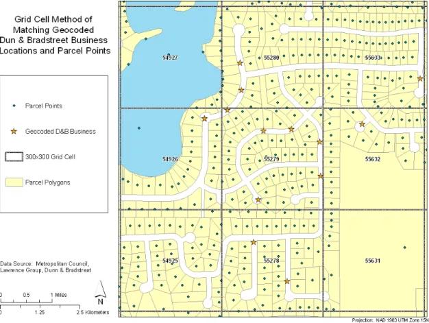
Grid Cell Matching
The remaining Dun & Bradstreet businesses that were not matched using the Oracle database method or the adapted geocoding method were used to test a final matching methodology using grid cells. For this approach the research team created a 300 by 300 meter grid covering the entire 7-County Metropolitan Area. Each grid cell was assigned a unique ID and each parcel point and geocoded business was assigned a grid cell ID based on the grid cell it fell within. Two tables containing the unique ID, grid cell ID, and address of each business and parcel were returned to the computer science research assistant, and by adapting the original Oracle matching method
businesses were matched to the parcel point with the closest matching street address that was also within the same or an adjacent grid cell as the geocoded business. Figure 3 shows an example of the grid cell matching system. Using this methodology, a business in grid cell number 55279 with the address 1600 Grand Avenue would be matched to the parcel point with the closest street address (i.e. 1612 Grand Avenue) that is located in the same or an adjacent grid cell (54927, 54926, 54925, 55280, 55279, 55278, 55633, 55632, 55631). Appendix F contains instructions for creating the grid and assigning grid cell IDs to points.
Figure 3: Grid Cell Matching Example
The grid cell methodology resulted in an additional 5,738 business/parcel semi-matches. Using this method also revealed that it is impossible to match some businesses to the closest parcel accurately because of gaps in the parcel dataset. These businesses have complete address data included in the Dun & Bradstreet dataset, but when geocoded fall in areas that have only parcels with “address unassigned” in their address fields. This occurred with 111 businesses in the 2005 datasets. These businesses were removed from the remainder of this analysis.
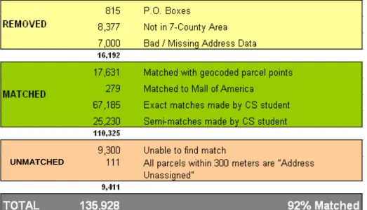
Matching Summary
The methodologies described above resulted in a total of 119,735 business/parcel matches. After removing the 16,192 businesses that were removed from the analysis due to bad and/or missing address data, only 9,411 businesses remained unmatched. This is a success rate of 92%. Figure 4 shows a detailed breakdown of how many businesses were matched using each method discussed above.
Figure 4: Business/Parcel Match Summary
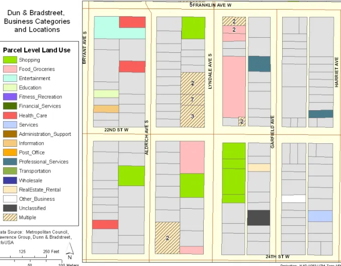
Figure 5 shows a sample of the matched business. It is important to note that the gray color represents parcels with no matching businesses. One of the goals of the Access to Destinations project is to create a three dimensional matrix that allows accessibility to be analyzed over time. To create this matrix at the parcel level of detail, parcel level land use layers will need to be created for multiple years. This report discusses the
methodologies used to match the 2005 Dun & Bradstreet dataset to the 2005 parcel dataset. Multiple methodologies were used for matching this dataset in order to identify which matching method is most effective and efficient. In the future when working with archived and new Dun & Bradstreet and parcel datasets we recommend using a slightly different approach. First, businesses that existed in 2005 and have already been matched should be selected out of each dataset by querying the DUNS ID number fields in Access. (Make sure that the business’s address has not changed, then set these aside.) The
remaining data should be cleaned extensively following the steps described in this report and records with bad and/or missing address data should be removed. The remaining
business records should be given to the Computer Science student to be matched in Oracle. Any remaining unmatched businesses should be geocoded, assigned grid cell IDs and then returned to the Computer Science student for final matching. This process will be the most efficient and result in the largest number of accurate matches.
Figure 5: Sample of Matched Businesses with Parcels Final Note
It is important to note that when performing a semi-match, businesses are linked to the nearest parcel on a prescribed side of the street. The nearest parcel might be a non-business establishment; it is therefore important to head caution when using the results of such matching for extremely detailed analysis. Better parcel and business datasets can lead to higher accuracy in reaching more perfect matches. In a best case scenario all matched data should be achieved during the first stage in the methodology using the geocoding process. Based on our knowledge and research conducted in the Twin Cities region, the parcel level data obtained from the Metropolitan Council is the best available data in terms of parcel accuracy at this scale. Also, the Dun and Bradstreet revealed much higher accuracy compared to other sources such as InfoUSA data.
REFERENCES
Baradaran, S., & Ramjerdi, F. (2001). Performance of accessibility measures in Europe. Journal of Transportation Statistics, 4(2/3), 31-48.
Ben-Akiva, M., & Lermand, S. (1977). Disaggregate travel and mobility choice models and measures of accessibility. Paper presented at the Proceedings of the Third International Conference on Behavioral Travel Modeling, Tanenda, Australia. Handy, S. (2002). Accessibility- vs. mobility-enhancing strategies for addressing
automobile dependence in the U.S. Paper presented at the European Conference of Ministers of Transport.
Handy, S. L., & Niemeier, D. A. (1997). Measuring accessibility: An exploration of issues and alternatives. Environment and Planning A, 29(7), 1175-1194.
Hansen, W. (1959). How accessibility shape land use. Journal of the American Institute of Planners, 25(2), 73-76.
Miller, H. (1999). GIS software for measuring space-time accessibility in transportation planning analysis. Paper presented at the International Workshop on Geographic Information Systems for Transportation and Intelligent Transportation Systems, Hong Kong.
Neuburger, H. (1971). User benefits in the evaluation of transport and land use plans. Journal of Transportation Economics and Policy, 5, 52-75.
Vickerman, R. W. (1974). Accessibility, attraction and potential: A review of some concepts and their use in determining mobility. Environment and Planning A, 6, 675-691.
Wachs, M., & Kumagai, T. (1973). Physical accessibility as a social indicator. Socioeconomic Planning Science, 7, 327-456.
Wu, Y., & Miller, H. (2002). Computational tools for measuring space-time accessibility within transportation networks with dynamic flow (special issue on accessibility). Journal of Transportation and Statistics, 4(2/3), 1-14.
APPENDIX A:
Destination Category
Reclassified Specific
Destination Original NAICS Code & Classification Shopping
441100 - Motor Vehicle Dealers,
Parts, and Maintenance 441110 New Car Dealers
441120 Used Car Dealers
441210 Recreational Vehicle Dealers
441221 Motorcycle Dealers
441222 Boat Dealers
441229 All Other Motor Vehicle Dealers
441310
Automotive Parts and Accessories Stores
441320 Tire Dealers
532111 Passenger Car Rental
532112 Passenger Car Leasing
532120
Truck, Utility Trailer, and RV (Recreational Vehicle) Rental and Leasing
811111 General Automotive Repair
811112
Automotive Exhaust System Repair
811113 Automotive Transmission Repair
811118
Other Automotive Mechanical and Electrical Repair and Maintenance
811121
Automotive Body, Paint, and Interior Repair and Maintenance
811122
Automotive Glass Replacement Shops
811191
Automotive Oil Change and Lubrication Shops
811192 Car Washes
811198
All Other Automotive Repair and Maintenance
442000 - Furniture and Home
Furnishing Stores 442110 Furniture Stores
442210 Floor Covering Stores
442291 Window Treatment Stores
442299 All Other Home Furnishings Stores
443000 - Electronics, Appliance,
and Camera Stores 443111 Household Appliance Stores
443112
Radio, Television, and Other Electronics Stores
443120 Computer and Software Stores
443130
Camera and Photographic Supplies Stores
444100 - Hardware Stores and
Home Centers 444110 Home Centers
444130 Hardware Stores
444101 - Specialized Building Material, Equipment, and Supply
Stores 444120 Paint and Wallpaper Stores
444190 Other Building Material Dealers
444210 Outdoor Power Equipment Stores
Destination Category
Reclassified Specific
Destination Original NAICS Code & Classification
Shopping (continued)
444101 - Specialized Building Material, Equipment, and Supply
Stores (continued) 453930
Manufactured (Mobile) Home Dealers
444220 - Nursery, Garden
Center, and Farm Supply Stores 444220
Nursery, Garden Center, and Farm Supply Stores
446120 - Beauty Supply and
Perfume Stores 446120
Cosmetics, Beauty Supplies, and Perfume Stores
447190 - Gas Station 447190 Other Gasoline Stations
447110
Gasoline Stations with Convenience Stores
448100 - Clothing, Shoe, and
Accessory Stores 448110 Men's Clothing Stores
448120 Women's Clothing Stores
448130
Children's and Infants' Clothing Stores
448140 Family Clothing Stores
448210 Shoe Stores
448150 Clothing Accessories Stores
448190 Other Clothing Stores
448310 Jewelry Stores
448320
Luggage and Leather Goods Stores
451100 - Sports, Hobby, and
Musical Instrument Stores 451110 Sporting Goods Stores
451120 Hobby, Toy, and Game Stores
451130
Sewing, Needlework, and Piece Goods Stores
451140
Musical Instrument and Supplies Stores
451220
Prerecorded Tape, Compact Disc, and Record Stores
451210 - Book Stores and
Newsstands (new) 451211 Book Stores
451212 News Dealers and Newsstands
452100 - Department Stores 452111
Department Stores (except Discount Department Stores)
452112 Discount Department Stores
453000 - Miscellaneous Store
Retailers 452990
All Other General Merchandise Stores
453110 Florists
453210
Office Supplies and Stationery Stores
453220 Gift, Novelty, and Souvenir Stores
453910 Pet and Pet Supplies Stores
453920 Art Dealers
453991 Tobacco Stores
812113 Nail Salons
812191 Diet and Weight Reducing Centers
812199 Other Personal Care Services
453998
All Other Miscellaneous Store Retailers (except Tobacco Stores)
532000 - Rental Goods 532210
Consumer Electronics and Appliances Rental
Destination Category
Reclassified Specific
Destination Original NAICS Code & Classification Shopping (continued)
532000 - Rental Goods
(continued) 532220 Formal Wear and Costume Rental
532230 Video Tape and Disc Rental
532291 Home Health Equipment Rental
532292 Recreational Goods Rental
532299 All Other Consumer Goods Rental
532310 General Rental Centers
453310 - Used Merchandise
Stores 453310 Used Merchandise Stores 454000 - Nonstore Retailers 454111 Electronic Shopping
454112 Electronic Auctions
454113 Mail-Order Houses
454210 Vending Machine Operators
454311 Heating Oil Dealers
454312
Liquefied Petroleum Gas (Bottled Gas) Dealers
454319 Other Fuel Dealers
454390
Other Direct Selling Establishments Food, Groceries, and
Restaurants
445110 - Supermarkets and
Grocery Stores 445110
Supermarkets and Other Grocery (except Convenience) Stores
445121 - Convenience Stores
(including those in gas stations) 445120 Convenience Stores
452910 - Warehouse Clubs and
Supercenters 452910 Warehouse Clubs and Supercenters
445200 - Specialty Food Stores 445210 Meat Markets
445220 Fish and Seafood Markets
445230 Fruit and Vegetable Markets
445291 Baked Goods Stores
311811 Retail Bakeries
445292 Confectionery and Nut Stores
445299 All Other Specialty Food Stores
445310 Beer, Wine, and Liquor Stores
722100 - Full-Service Restaurant 722110 Full-Service Restaurants
722211 Limited-Service Restaurants
722212 Cafeterias
722213 - Snack and
Nonalcoholic Beverage Bars (i.e.
coffee shops) 722213
Snack and Nonalcoholic Beverage Bars
722300 - Other Food Service 722310 Food Service Contractors
722320 Caterers
722330 Mobile Food Services
722410 - Bars/Nightclubs 722410
Drinking Places (Alcoholic Beverages)
Fitness and Recreation
713940 – Fitness and Recreation
Centers 713940
Fitness and Recreational Sports Centers
611620 Sports and Recreation Instruction
Parks using land use data
Entertainment 512130 – Movie Theaters 512131
Motion Picture Theaters (except Drive-Ins)
Destination Category
Reclassified Specific
Destination Original NAICS Code & Classification Entertainment
(continued)
711000 – Performing Arts and/or
Spectator Sports 711110
Theater Companies and Dinner Theaters
711120 Dance Companies
711130 Musical Groups and Artists
711190 Other Performing Arts Companies
711211 Sports Teams and Clubs
711212 Racetracks
711219 Other Spectator Sports
712000 – Amusement and
Recreation 712110 Museums
712120 Historical Sites
712130 Zoos and Botanical Gardens
713110 Amusement and Theme Parks
713120 Amusement Arcades
713210 Casinos (except Casino Hotels)
713290 Other Gambling Industries
713950 Bowling Centers
713990
All Other Amusement and Recreation Industries
721120 Casino Hotels
713900 - Outdoor Recreation
(Camps, Golf, etc.) 713910 Golf Courses and Country Clubs
713920 Skiing Facilities
713930 Marinas
721211
RV (Recreational Vehicle) Parks and Campgrounds
721214
Recreational and Vacation Camps (except Campgrounds)
Health Care
446110 - Pharmacies and Drug
Stores 446110 Pharmacies and Drug Stores
446190 - Health, Medical, and
Personal Care Stores 446130 Optical Goods Stores
446191 Food (Health) Supplement Stores
446199
All Other Health and Personal Care Stores
621111 – Doctors' Offices 621111
Offices of Physicians (except Mental Health Specialists) 621210 – Dentists' Offices 621210 Offices of Dentists
621100 – Specialized Health
Care Facility/Office 621112
Offices of Physicians, Mental Health Specialists
621310 Offices of Chiropractors
621320 Offices of Optometrists
621330
Offices of Mental Health
Practitioners (except Physicians)
621340
Offices of Physical, Occupational and Speech Therapists, and Audiologists
621391 Offices of Podiatrists
621399
Offices of All Other Miscellaneous Health Practitioners
Destination Category
Reclassified Specific
Destination Original NAICS Code & Classification Health Care
(continued)
621100 – Specialized Health
Care Facility/Office (continued) 621420
Outpatient Mental Health and Substance Abuse Centers
621491 HMO Medical Centers
621492 Kidney Dialysis Centers
621493
Freestanding Ambulatory Surgical and Emergency Centers
621498 All Other Outpatient Care Centers
622210
Psychiatric and Substance Abuse Hospitals
622310
Specialty (except Psychiatric and Substance Abuse) Hospitals 621500 – Health Services 621511 Medical Laboratories
621512 Diagnostic Imaging Centers
621610 Home Health Care Services
621910 Ambulance Services
621991 Blood and Organ Banks
621999
All Other Miscellaneous
Ambulatory Health Care Services
622110 – General Hospital 622110
General Medical and Surgical Hospitals
623000 – Residential Care
Facilities 623110 Nursing Care Facilities
623210
Residential Mental Retardation Facilities
623220
Residential Mental Health and Substance Abuse Facilities
623311
Continuing Care Retirement Communities
623312 Homes for the Elderly
623990 Other Residential Care Facilities
Library 519120 – Libraries 519120 Libraries and Archives Post Office 491110 - Postal Service 491110 Postal Service Financial Services 522000 – Banking 522110 Commercial Banking
522120 Savings Institutions
522130 Credit Unions
522190
Other Depository Credit Intermediation
521000 – Other Financial/Insurance
All other Financial and Insurance (520000) classifications
Education 624410 – Child Care 624410 Child Day Care Services
611110 - Elementary and
Secondary Schools 611110
Elementary and Secondary Schools
611200 - Postsecondary Schools
and Technical Training 611210 Junior Colleges
611310
Colleges, Universities, and Professional Schools
611410 Business and Secretarial Schools
611420 Computer Training
611430
Professional and Management Development Training
611511 Cosmetology and Barber Schools
Destination Category
Reclassified Specific
Destination Original NAICS Code & Classification Education (continued)
611600 - Other Schools and
Instruction 611513 Apprenticeship Training
611519 Other Technical and Trade School
611610 Fine Arts Schools
611630 Language Schools
611691 Exam Preparation and Tutoring
611692 Automobile Driving Schools
611699
All Other Miscellaneous Schools and Instruction
Personal Services 624000 – Social Services 624110 Child and Youth Services
624120
Services for the Elderly and Persons with Disabilities
624190
Other Individual and Family Services
624210 Community Food Services
624221 Temporary Shelters
624229
Other Community Housing Services
624230
Emergency and Other Relief Services
624310 Vocational Rehabilitation Services
721110 - Hotels and Traveler
Accommodation 721110
Hotels (except Casino Hotels) and Motels
721191 Bed-and-Breakfast Inns
721199 All Other Traveler Accommodation
721310 - Rooming and Boarding
Houses 721310 Rooming and Boarding Houses
811210 - Electronics Repair and
Maintenance 811211
Consumer Electronics Repair and Maintenance
811212
Computer and Office Machine Repair and Maintenance
811213
Communication Equipment Repair and Maintenance
811219
Other Electronic and Precision Equipment Repair and Maintenance
323000 - Copying and Printing
Services 323114 Quick Printing
561439 Other Business Service Centers
811310 - Commercial and Industrial Repair and
Maintenance 811310 Commercial and Industrial Machinery and Equipment (except Automotive and Electronic) Repair and Maintenance
811400 - Personal and Household Goods Repair and
Maintenance 811411 Home and Garden Equipment Repair and Maintenance
811412 Appliance Repair and Maintenance
811420 Reupholstery and Furniture Repair
811430
Footwear and Leather Goods Repair
811490
Other Personal and Household Goods Repair and Maintenance
Destination Category
Reclassified Specific
Destination Original NAICS Code & Classification Personal Services
(continued)
812110 - Barber Shops and
Beauty Parlors 812111 Barber Shops
812112 Beauty Salons
812200 - Death Care Services 812210 Funeral Homes and Services 812220 Cemeteries and Crematories
812300 - Laundry and
Drycleaners 812310
Coin-Operated Laundries and Drycleaners
812320
Drycleaning and Laundry Services (except Coin-Operated)
812900 - Other Personal
Services 812910
Pet Care (except Veterinary) Services 812921 Photofinishing Laboratories (except One-Hour) 812922 One-Hour Photofinishing 812990
All Other Personal
ServicesProfessional, and Similar Organizations
813110 - Religious Organizations 813110 Religious Organizations
813300 - Civic, Social, Political, Business and Other
Organizations 813311 Human Rights Organizations
813312
Environment, Conservation and Wildlife Organizations
813319
Other Social Advocacy Organizations
813410 Civic and Social Organizations
813910 Business Associations
813920 Professional Organizations
813930
Labor Unions and Similar Labor Organizations
813940 Political Organizations
813990
Other Similar Organizations (except Business, Professional, Labor, and Political Organizations)
492110 Couriers
492000 - Couriers and Messengers
492210
Local Messengers and Local Delivery
Airport use land use data
Transportation 480000 - Transportation
All Transportation (480000) classifications not included in previous destination categories
Wholesale 420000 - Wholesale Trade
All Wholesale Trade (420000) classifications not included in previous destination categories
Information
510000 – Information and Communications
All Information and Communications (510000) classifications not included in previous destination categories
Real Estate / Rental
531000 - Real Estate, Rental, and Leasing
All Real Estate, Rental, and Leasing (530000) classifications not included in previous destination categories
Professional Services
541110 - Professional, Scientific and Technical Services
All Professional, Scientific and Technical Services (540000) classifications not included in previous destination categories
Administration / Support
560000 - Administration and Support
All Administrative and Support and Waste Management and Remediation Services (560000) classifications not included in previous destination categories
Destination Category
Reclassified Specific
Destination Original NAICS Code & Classification Other 100000 - Other Agriculture, Forestry, Fishing, and Hunting
Mining
Utilities
Construction
Manufacturing
Management of Companies and Enterprises
Public Administration
APPENDIX B:
‘ To use this syntax, open the Dun & Bradstreet business table in SPSS ‘ Click File…New…Syntax
‘ Copy and paste all of the text into the syntax window that opens ‘ Click the Run button
‘ The syntax will run and create three new columns in the table ‘ “Dest_code” is the specific destination recode.
‘ See Appendix A for a list of the titles of each specific destination recode ‘ (i.e. Dest_code 441100 = Motor Vehicle Dealers and Maintenance) ‘ “Dest_cat is the destination category code
‘ “Cat_Descrip” is the text label for each destination category (i.e. “Shopping”)
‘ Recode Dun & Bradstreet primary NAICS classification to new specific destination code ‘ Place new code in new column titled ‘Dest_code’
RECODE primarynaics
(522210 thru 525990=521000) (481111 thru 488999=480000) (420000 thru 429999=420000) (510000 thru 512129=510000) (512133 thru 519999=510000) (531000 thru 532209=531000) (532300 thru 539999=531000) (541100 thru 541999=541110) (561100 thru 562999=560000) (921110 thru 928120 = 921000) (551000 thru 551114=551000) (999990=Copy) (441110=441100) (441120=441100) (441210=441100) (441221=441100) (441222=441100) (441229=441100) (441310=441100) (441320=441100) (532111=441100) (532112=441100) (532120=441100) (811111=441100) (811112=441100) (811113=441100) (811118=441100) (811121=441100) (811122=441100) (811191=441100) (811192=441100) (811198=441100) (442110=442000) (442210=442000) (442291=442000) (442299=442000) (443111=443000) (443112=443000) (443120=443000) (443130=443000) (444110=444100) (444130=444100) (444120=444101) (444190=444101) (444210=444101) (453930=444101) (444220=444220) (446120=446120) (447190=447190) (447110=447190) (448110=448100) (448120=448100) (448130=448100) (448140=448100) (448150=448100) (448190=448100) (448210=448100) (448310=448100) (448320=448100) (451110=451100) (451120=451100) (451130=451100) (451140=451100) (451220=451100) (451211=451210) (451212=451210) (452111=452100) (452112=452100) (452990=453000) (453110=453000) (453210=453000) (453220=453000) (453910=453000) (453920=453000) (453991=453000) (812113=453000) (812191=453000) (812199=453000) (453998=453000) (532210=532000) (532220=532000) (532230=532000) (532291=532000) (532292=532000) (532299=532000) (532310=532000) (453310=453310) (454111=454000) (454112=454000) (454113=454000) (454210=454000) (454311=454000) (454312=454000) (454319=454000) (454390=454000) (445110=Copy) (445120=Copy) (452910=Copy) (445210=445200) (445220=445200) (445230=445200) (445291=445200) (311811=445200) (445292=445200) (445299=445200) (445310=445200) (722110=722100) (722211=722100) (722212=722100) (722213=Copy) (722310=722300) (722320=722300) (722330=722300) (722410=Copy) (713940=713940) (611620=713940) (512131=512130) (512132=512130) (711110=711000) (711120=711000) (711130=711000) (711190=711000) (711211=711000) (711212=711000) (711219=711000) (712110=712000) (712120=712000) (712130=712000) (713110=712000) (713120=712000) (713210=712000) (713290=712000) (713950=712000) (713990=712000) (721120=712000) (713910=713900)
(713920=713900) (712190=713900) (713930=713900) (721211=713900) (721214=713900) (446110=Copy) (446130=446190) (446191=446190) (446199=446190) (621111=Copy) (621210=Copy) (621112=621100) (621310=621100) (621320=621100) (621330=621100) (621340=621100) (621391=621100) (621399=621100) (621410=621100) (621420=621100) (621491=621100) (621492=621100) (621493=621100) (621498=621100) (622210=621100) (622310=621100) (621511=621500) (621512=621500) (621610=621500) (621910=621500) (621991=621500) (621999=621500) (622110=Copy) (623110=623000) (623210=623000) (623220=623000) (623311=623000) (623312=623000) (623990=623000) (519120=Copy) (491110=Copy) (522110=522000) (522120=522000) (522130=522000) (522190=522000) (624410=Copy) (611110=Copy) (611210=611200) (611310=611200) (611410=611200) (611420=611200) (611430=611200) (611511=611200) (611512=611200) (611513=611200) (611519=611200) (611610=611600) (611630=611600) (611691=611600) (611692=611600) (611699=611600) (624110=624000) (624120=624000) (624190=624000) (624210=624000) (624221=624000) (624229=624000) (624230=624000) (624310=624000) (721110=721110) (721191=721110) (721199=721110) (721310=721110) (811211=811210) (811212=811210) (811213=811210) (811219=811210) (323114=323000) (561439=323000) (811310=Copy) (811411=811400) (811412=811400) (811420=811400) (811430=811400) (811490=811400) (812111=812110) (812112=812110) (812210=812200) (812220=812200) (812310=812300) (812320=812300) (812910=812900) (812921=812900) (812922=812900) (812990=812900) (813110=Copy) (813311=813300) (813312=813300) (813319=813300) (813410=813300) (813910=813300) (813920=813300) (813930=813300) (813940=813300) (813990=813300)
(492110=492000) (492210=492000) (812930=480000) (Else=100000) INTO dest_code . VARIABLE LABELS dest_code 'Destination Type Code'.
EXECUTE .
‘ Recode specific destination codes into larger destination categories ‘ Place new code in new column titled ‘Dest_cat’
RECODE dest_code (441100=1) (442000=1) (443000=1) (444100=1) (444101=1) (444220=1) (446120=1) (447190=1) (448100=1) (451100=1) (451210=1) (452100=1) (453000=1) (532000=1) (453310=1) (454000=1) (445110=2) (445120=2) (452910=2) (445200=2) (722100=2) (722213=2) (722300=2) (722410=2) (713940=3) (512130=5) (711000=5) (712000=5) (713900=5) (446110=6) (446190=6) (621111=6) (621210=6) (621100=6) (621500=6) (622110=6) (623000=6) (519120=7) (491110=8) (522000=9) (521000=9) (624410=10) (611110=10) (611200=10) (611600=10) (624000=11) (721110=11) (811210=11) (323000=11) (811310=11) (811400=11) (812110=11) (812200=11) (812300=11) (812900=11) (813110=11) (813300=11) (492000=11) (480000=13) (420000=14) (510000=15) (531000=16) (541110=17) (560000=18) (921000=18) (551000=18) (100000=19) (999990=20) INTO dest_cat . VARIABLE LABELS dest_cat 'Destination Type Category'.
‘ Create label field for larger destination categories ‘ Place label in new column titled ‘Cat_descrip’ STRING cat_descrip (A30) .
RECODE dest_cat
(1='Shopping') (2='Food') (3='Fitness') (4='Parks') (5='Entertainment') (6='Health Care') (7='Library') (8='Post Office') (9='Bank or'+
' Insurance') (10='Education') (11='Services') (12='Airport')
(13='Transportation') (14='Wholesale Trade') (15='Information') (16='Real'+ ' Estate and Rental') (17='Professional Services') (18='Administration and'+ ' Support') (19='Other') (20='Unclassified') INTO cat_descrip .
VARIABLE LABELS cat_descrip 'Destination Category Description'. EXECUTE .
APPENDIX C:
Instructions for Matching Dun & Bradstreet and Parcel Point Data
Using Oracle Database (provided by CS GRA)
1- Text manipulation using gawk (open source software) and Textpad to modify input files to be in ready format for the next stage.
2- Load data (business data and parcel points) into database (I have used Oracle Express edition), throwing away business addresses with not matched zip code. 3- Parse business addresses and parcel points using program with c# and load the
parsed data to data base to join, the parsing program also standardizes street names using Alternate name table. The program replaces abbreviation (e.g. COUNTY ROAD ïƒ CO RD)
4- As the database is read only, we create an index over all attributes and perform a join query to get the matched addresses.
5- When the grid has been introduced; other program has been developed to perform the search within the grid only.
Recommendation for Next data
1- Addresses for parcel point and business address should be geo-coded to make the search more narrowed to improve the speed to find matched pair, no grid is necessary.
2- Alternate name should be standardized; I think the address get from geo-coding can be used to standardize the names.
APPENDIX D:
Files returned by the CS student are text files with three columns of information, the Duns number, the parcel pin that the business was matched to, and a “score” showing the accuracy of the match (similar to the score given to geocoding matches in ArcGIS). Import this table into Access along with the original table of all D&B businesses (located at D:\Dunn&Bradstreet\originaldatadownload) and the table of parcel points for the 7 county metro area (the original parcel point file had duplicate points and did not contain accurate X/Y coordinates, so a cleaned version of this file with X/Y coordinates for each point in UTM zone 15 projection is available at
D:\Dunn&Bradstreet\originaldatadownload\D&Bbusinesses_Metroparcels.mdb\Parcel_p oints_CLEANED).
Create a query that adds the rest of the D&B and parcel attributes to these three columns. Select about 20 random businesses and double check that the D&B and parcel addresses are good matches. Even building numbers should be matched to even building numbers and odds to odds. Make sure that highways are not being matched to county road parcels and vice versa.
Save the query as a new table by right clicking on the name of the query and exporting the query as a dbf table.
Open ArcGIS, add the table, right click on its name, and click Add XY Data…
In the dialogue box, select the table fields with the X and Y data for the parcel points and select the UTM 1983 Zone 15 projection. Click OK.
Right click on the resulting XY event layer, click Data…Export, and save the points as a shapefile.
APPENDIX E:
Matching D&B Businesses to Parcel Points Using the Adapted
Geocoding Method
1. Add the Lawrence Group street centerline shapefile (D:\Networks\TLG_metro.shp) and the table of unmatched Dun & Bradstreet business addresses to ArcGIS.
2. Right click on the name of the table and select Geocode Addresses…
3. In the address locator dialogue box select the locator named “TLG 2006”. If this locator is not listed in the box, click the Add button. Navigate to the folder
G:\KKRIZEK\Data\GISData\AddressLocators or navigate to your local Address Locators folder (listed below the lettered drives in the pull-down “Look in:” menu). If you cannot find the address locator, click Cancel and you can create a new one easily using the directions on ESRI’s website:
http://webhelp.esri.com/arcgisdesktop/9.2/index.cfm?id=4533&pid=4531&topicname=Cr eating_an_address_locator
4. Click OK
5. In the Geocode Addresses dialogue box, use the pull-down menus to indicate the fields that different address data elements are located in.
6. Type in the location where you want the output shapefile to be stored and the name of the file.
7. Click the “Geocoding Options…” button and uncheck “Match if candidates tie”. You can also adjust the spelling sensitivity and the minimum score for something to be considered a match in this window if you want. Click OK.
8. Click OK and ArcGIS will geocode the table and add a shapefile containing the geocoded points to the map. The Review/Rematch Addresses window will appear and show the geocoding success rate.
9. If there are addresses that are tied, click the “Addresses with candidates tied” radio button and click “Match Interactively”. For each of the addresses with tied candidates, highlight the address that is the closest match in the candidates window, then click Match. After matching all of the tied addresses with tied candidates, click Done.
10. Next, click the “Unmatched Addresses” radio button and click “Match Interactively”. Go through each of these addresses and correct any spelling errors or errors in ArcGIS’s address standardization as necessary to find the closest match candidate for each
business, highlight it in the candidates window, then click Match. After you have found a match for as many unmatched businesses as possible, click Done.
11. After geocoding the Dun & Bradstreet businesses, add the parcel points shapefile to ArcGIS (D:\2007parcels\Metro\all_7_parcel_pts.shp)
12. Since the geocoded Dun & Bradstreet points are usually drawn reasonably close to the correct parcel and the parcel points shapefile has over 1 million features, you will want to create a new shapefile that just contains the parcel points that are located within a