Article
1
Evolution and Collapse of
Ejidos
in Mexico: How Far
2
is Communal Land Used for Urban Development?
3
Melissa Schumacher 1, Pamela Durán-Díaz 2*, Anne Kristiina Kurjenoja 3, Eduardo
Gutiérrez-4
Juárez 4 and David A. González-Rivas 5,
5
1 Department of Architecture, Universidad de las Américas Puebla, Santa Catarina Mártir s/n, 72810
6
Cholula, Mexico; [email protected]
7
2 Chair of Land Management, Technische Universität München, Arcistrasse 21, 80333 Munich, Germany;
8
9
3 Department of Architecture, Universidad de las Américas Puebla, Santa Catarina Mártir s/n, 72810
10
Cholula, Mexico; [email protected]
11
4 Department of Architecture, Universidad de las Américas Puebla, Santa Catarina Mártir s/n, 72810
12
Cholula, Mexico; [email protected]
13
5 Centro de Investigaciones Biológicas del Noreste CONACYT, Avenida Instituto Politécnico Nacional 195,
14
Playa Palo de Santa Rita Sur, 23205 La Paz BCS, Mexico; [email protected]
15
* Correspondence: [email protected]; +49 89 289 25789
16
17
Abstract:
18
The ejido system in Mexico based on communal land was transformed for private ownership due to
19
neoliberal trends during 1990. This research describes the evolution of Mexican land policies that
20
changed the ejido system into private development to answer why land tenure change is shaping
21
urban growth. To demonstrate this, municipalities of San Andrés Cholula and Ocoyucan were
22
selected as a case study. Within this context, we evaluated how much ejido land is being urbanized
23
due to real estate market forces and what type of urbanization model is created. These two areas
24
represent different development scales: S.A. Cholula where its ejidos were expropriated as part of a
25
regional urban development plan; and Ocoyucan where its ejidos and rural land were reached by
26
private developers without local planning. To analyze both municipalities, historical satellite
27
images from Google Earth were used with GRASS GIS 7.4 and corrected with QGIS 2.18. We found
28
that privatization of ejidos fragmented and segregated the rural world for the construction of
29
massive gated-communities. Therefore, a disturbing land tenure change occurred during the last 30
30
years, hence this research questions the role of local authorities in permitting land use change
31
without regulations or local planning. The resulting urbanization model is a private sector
32
development that isolates rural communities in their own territories, for which we provide
33
recommendations.
34
Keywords: land tenure in Mexico; ejido system; land expropriation; gated-communities; San Andrés
35
Cholula, Ocoyucan.
36
37
38
1. Introduction
39
Mexico has an intricate land-tenure-system with historical bonds between communal lands, and
40
public and private ownership. The ejido is, thus, an endemic land tenure model and one of the most
41
important bequests of the Mexican Revolution consisting on “an area of communal land used for
42
agriculture, on which community members individually farm designated parcels and collectively
43
maintain communal holdings”[1]. Conversely, during the past 100 years the evolution of tenure
44
systems changed radically when ejido land was opened to the free-market.
45
As a system, ejido is widely studied in Mexico and Latin America because of its complexity and
46
importance as an agrarian land policy [2][3][4], its fragile socioeconomic structure [5][1][6], its
socio-47
spatial organization [7][8][9], its urbanization [10][11][12], and its liberalization [13][14][15] through
48
the reforms of the Article 27 of the Mexican Constitution. Most ejido land underwent a transformation
49
in response to neoliberal trends during the 1980s and 1990s, when private ownership was secured by
50
ejidatarios and farmers, which, while on the face of a positive step, subsequently opened the door to
51
corporate predation.
52
The paradox of ejido system is, as it is going extinct because it is considered for land policies as
53
an “irregular land tenure system”, half of Mexico’s territory is still held by ejidos and agrarian
54
communities, including mountains, forests, natural reserves, mines, and lakes, among others [16].
55
“More than 5.6 million of ejidatarios offer to National and international markets food, cattle, raw
56
materials, fodder, as well as construction materials, handcrafts and touristic services. Moreover,
57
they provide invaluable environmental services for biodiversity conservation, carbon capture
58
and aquifer recharge1” [idem]
59
Privatization of ejido tenure means, thus, that agricultural and natural land are potentially urban.
60
Adding ejido and communal land to urban development has different approaches, described by
61
Riveros Fragoso in terms of urban impact, ecological implications, transformation of rural economy,
62
socioeconomic issues, land policies, and governance accountability[17]. The legal and tenure
63
approach, however, has not been addressed before although it is essential to get an integral
64
understanding of the implications of the urbanization of the rural world.
65
Riveros Fragoso identifies three main periods for ejido land incorporation to urban land uses:
66
1940-1973 (irregular tenure), 1970-1992 (regularization of ejidos), and 1992 till today (de-regularization
67
of ejidos). During this latter, the last Ejidal Census of 2007 counted 3,097,658.83 hectares of ejido land
68
sold to buyers outside of rural communities. The last Agrarian Census from 2017 counted a decrease
69
in the number of ejidos in Mexico, from more than 31,000 to 28,000. While the number of ejidos is
70
decreasing at a rate of 10% in ten years, more than 198.5 million hectares of the National territory are
71
still communal-based land tenure, such as ejidos.
72
The transformation of the rural world was triggered by NAFTA and the reforms of the Article
73
27, which challenged the survival of rural communities. The immediate needs of ejidatarios, farmers
74
and peasants together with the political and socioeconomic conditions set by urban rather than rural
75
stakeholders were addressed in the form of land expropriation for urban development.
76
These conditions were faced in the municipalities of San Pedro Cholula and San Andrés Cholula,
77
in the Metropolitan Area of Puebla-Tlaxcala, where the life of rural population changed radically
78
when the regional Government [18] expropriated 1,092 Hectares of ejido land for the implementation
79
of an urban development plan called “Programa de Ordenamiento Territorial Angelópolis” PROTA
80
– commonly named as Plan Angelópolis.
81
On one hand, the implementation of PROTA was an exemplary case of urban planning in Mexico
82
that shaped urban growth and gave tenure security to ejidatarios and farmers. On the other hand, in
83
its implementation, the plan triggered the fragmentation of ejidos and the segregation of the rural
84
population [19]. These twin effects fuel the current debate about modern land policies in Mexico and
85
the extent to which they promote urban-private development in the country.
86
This paper contributes to the research on the ejidos and periurban growth in order to answer
87
three main questions: A)How does land tenure change shape urban growth in Mexico? B) How
88
much ejido and rural land is used for private sector urbanization? C) Which model of urbanization
89
emerges from this? To respond these questions,we first reviewed the evolution of the land tenure
90
system in Mexico, as a historical review of land policies is fundamental to understand the reasons
91
ejidos were created and then liberalized. Second, we conducted a visual geo-analysis of satellite
92
images, selecting the case studies of the municipalities of San Andrés Cholula and Ocoyucan as
93
typical ejidos, in order to quantify their urbanization from 1995 to 2018.
94
This research is divided into four sections: first, we describe the theoretical framework of land
95
and urban development; second, we outline our approach to the modern land tenure system in
96
Mexico with a description of local urban planning through PROTA; third, we conduct a geo-visual
97
analysis to measure how much land was urbanized in the cases under study. Fourth, we provide our
98
results and in the discussion, critically assess private sector urbanization of ejido land and the role of
99
public policies and local administrations in promoting land privatization. Finally, we conclude that
100
the tendency of the model of urbanization based on private development to isolate rural communities
101
in their own territory means that the benefits are outweighed by the negative impacts.
102
103
2. Theoretical framework: land and urban development
104
105
The core object of study of this paper is ejido land. Based on Robles [20] description, a typical
106
ejido had 1822 hectares distributed by 104 ejidatarios. Normally, for an ejido of this size it was divided
107
in 134 plots with a maximum of 10 hectares per each. In every ejido it should be considered the area
108
for human settlements with an average of 9.4 hectares where ejidatarios and neighbors lived.
109
On one hand, ejidos became the axiom of Mexico’s rural land distribution. On the other hand,
110
they became an obsolete tenure system that did not achieve better quality of life nor wealth to its
111
tenants. And, due to socioeconomic change, the ejido land near to urban areas became an object of
112
desire for land speculators. According to the original National Agrarian Law, selling, buying or
113
developing ejido land was not permitted, however this condition did not stop informal settlements.
114
After the liberalization of ejidos in 1992, low-priced ejido and rural land was available for the big
115
housing market, especially when conurbated with urban areas. Through this public policy, the
116
urbanization of ejidos caused massive urban sprawl outside urban cores, thus huge metropolitan
117
areas emerged.
118
Harvey defines metropolitan areas as large collaborative enterprises of competitive processes,
119
diversifications, production of built environments and public spaces, divergent temporalities, values,
120
lifestyles and means of production [21]. In these terms, all territorial politics (be they local, urban or
121
regional) are based on the collective development of a particular political vision on the part of
122
particular persons in particular places at particular times [p.p.188]. These politics, be it from the state
123
or stimulated by real estate developers, may clash with local cultures and community interests
124
threatening their rights and values as threatening powerful political forces. All public policy should
125
thus confront the issue of ‘locality’ and ‘community’ somehow seeking for alternative and responsible
126
forms of social change [p.p.192]
127
In metropolitan areas, certain areas experience a net gain in land value while others suffer a net
128
loss impacting the geography of accumulation and formation of centers and peripheries at every
129
spatial scale [26 p.p.113]. In terms of potential use of the urban land, a struggle frequently rises from
130
the exploitative structures of the vertical and horizontal class divisions of society, in a socio-spatial
131
dialectic triggering the articulation of social and spatial praxis [p.p.98] and creating a socio-territorial
132
division of the city. Thus, themes of power, coercion, and collective resistance shape to the urban
133
territory as a social microcosm the spatiality of which reflects the mode of production in
134
corresponding to its time [22 p.p.149]. As stated by Zukin, “from this perspective, the underlying
135
investment in industry and in property, cycling it into new construction or reconstruction, shuttling
137
it between the downtown and the suburban periphery” [p.p.19].
138
In today’s struggle for expansion in the built environment and control over the land use,
139
economic power predominates over both the state and community interests. "Capital creates and
140
destroys its own landscape." [23 p.p.38]. As the consequence, new urban forms and territorial
141
articulations are produced under nearly the same social conditions as consumer products following
142
similar patterns of both standardization and market differentiation [p.p.42]. Moreover, in the context
143
of globalization it has become practically impossible to separate the perception of urban form from
144
the effects of global financial flows, investment, production, and consumption [idem].
145
In globalizing metropolis, property values seem to point to a renaissance, and redevelopment
146
through "better" uses looks like a zone’s new lease on life. Thus, local governments have no quarrel
147
with real estate developers as it depends on the private sector to build the city.
148
“Through a kind of reciprocity, developers allow politicians to take the credit for it. But
149
any relation that is ruled by mutual advantage also implies obligation. Operating in an
150
economic system where capital mobility is the norm, both politicians and developers want
151
guarantees. Developers want to know that the project they undertake today will not be
152
subverted by external factors tomorrow. Politicians want the jobs and dollars that developers
153
promise to last until the next election day” [23 p.p. 149].
154
Kivell [25] explains the importance of land as a primary element with “extraordinary features”
155
such as: fixed supply, no cost of supply, irreplaceable, immobile, and permanent, denoting that land
156
is a finite resource. Still, the alternation of movement and settlement are key activities of human life
157
and interaction [26], therefore urban and population growth are always the main elements of land
158
development [27]. Land uses are fundamental to control future production systems, but in association
159
with land tenure, they are essential tools that seek developable land in order to manage urban
160
growth.
161
According to Font [28], when expansive urban growth and sprawl occur, spatial development is
162
affected by: population growth outside urban cores, decentralization of industrial and commercial
163
activities, population mobility, flows and goods, fragmentation of the environment, and creation of
164
new centralities inside metropolitan areas impacts on spatial development. These factors are as well
165
agents of change that participate in the production and control of urbanization, well defined by
166
Lefebvre[29] . Therefore, the concept of urbanization as an agent of change is taken for this paper to
167
describe how rural land is transformed into urban with “simultaneous role as places of consumption
168
and as consumable places”[29], as market forces are a mechanism that transforms urban morphology.
169
In regard to the concept of peri-urbanization used in this paper, we must refer to Vázquez’s
170
concept of “new suburb”, which describes the multifunctional and extensive urban peripheries in
171
which urban areas are “liquidated” together to form a brand new plural territory that does not respect
172
state and municipal limits [30]. This “liquidated city” can be found in Puebla’s metropolitan area in
173
which several communities are fused together and the urban growth has extended beyond the
174
administrative boundaries between Puebla and Tlaxcala states. Hence, in our case study the
175
prediction of Lewis Mumford, Frank Lloyd Wright and Le Corbusier has come true: the urban
176
territory is dissolving into a gigantic and fragmented region in which it is difficult to distinguish
177
centricities and borders [p.p 141]. In these galaxy-like urban patchworks of a profoundly
178
converge [p.p 142]. The city is thus not a unified spatial unit anymore but an archipelago of enclaves
180
without connection to the urban whole forming a diffuse, extensive and multi-hierarchical territory
181
difficult to understand and to define [p.p. 151].
182
Edward D. Soja points out that under the complex contemporary urban conditions, it is
183
impossible to separate the center from the suburbs and these from the agricultural land [31] [p.p.
184
151]. Edward E. Land [31 p.p. 152] on the other hand complements this stance with the observation
185
of the emergence of a new peripheral concept, “the city without borders” of an extremely disperse
186
and amorphous urban territory, with different kinds of land occupation scattered over it,
187
characterized by very low density and modest edifications, present in the Mexican perirural areas. In
188
the context of contemporary metropolitan areas, Mike Davis [33 p.p 153] highlights the struggle for
189
the land as part of the processes of “colonization” of the peripheries, in which “conquerors” of the
190
higher social classes clash with the peripheral population in struggles of the possession of land in
191
which the latter resist to abandon their territories. When the first achieved to gain possession of new
192
lands through expropriations or aggressive real estate business, they feel the necessity to protect
193
themselves of the seemingly different others perceived as dangerous. The result is the emergence of
194
gated communities and other systems of urban surveillance. Davis called these walls and surveillance
195
systems as new socio-spatial borders or “new urban frontiers” triggered by real estate business
196
promoted by the public administration and its public policy.
197
Schumacher[19] abounds in the changes described by Davis, as the result of a global attraction
198
to urban quality of life. Pierre Bourdieu [34] defines the specific planning tools that are used to create
199
the “New urban frontiers” mentioned by Davis and to promote “urban quality of life” as stated by
200
Schumacher. In order to establish their presence and land occupation in an area, the “conquerors”
201
promote land occupation favoring boutiques, shopping centers, art galleries, bars, restaurants and
202
other entertainment centers able to hold off undesirable socio-economic groups and classes.
203
Simultaneously, housing costs inside urban cores generates another type of spatial development
204
beyond rural territory: periurbanization.
205
As a process, Schumacher [19 p.p 37] states that periurbanization has a particular interest
206
between rural and urban boundaries, especially for “land developers and informal settlements” but
207
this does not mean that local communities lose completely their rural essence. This factor is
208
elementary to understand rural-urban ambiguity in Latin America where socioeconomic groups are
209
physically and socially fragmented. James Corner [35] in his article “Terra Fluxus” explained the
210
necessity to pay more attention to processes of change-“terra fluxus” in planning, in order to
211
understand the metropolitan areas as stratifications of “fields of action” generating interactive
212
ecosystems considering culture, collective memories and desires of the citizens. This concept has
213
usability in Latin American periurbanization as a flexible model for sensitive planning.
214
“We live in an era when ideals of human rights have moved center-staged both ethically and
215
politically” [36 p.p. 3]. A lot of political energy invested into promoting, protecting, and articulating
216
their significance in the construction of a better world. Though, for the most part these concepts are
217
understood as individualistic and property-based and, as such, “do nothing to challenge hegemonic
218
liberal and neoliberal market logics, or neoliberal modes of legality and state action. We live in a
219
world, after all, where the rights of private property and the profit rate trump all other notions of
220
rights one can think of” [idem]. Still, the question of what kind of city we want is intimately related
221
construct, what is our relation regarding the nature, what kind of life style do we seek and what
223
values we hold [idem].
224
“The right to the city is, therefore, far more than a right of individual or group access to
225
the resources that the city embodies: it is a right to change and reinvent the city more after
226
our hearts' desire. It is, moreover, a collective rather than an individual right, since
227
reinventing the city inevitably depends upon the exercise of a collective power over the
228
processes of urbanization” [p.p. 4].
229
230
231
3. An approach to modern land tenure system in Mexico
232
3.1 From haciendas to agrarian Reform
233
234
At the end of Colonial period in 1821, when Mexico achieved independence from the Kingdom
235
of Spain, the new country inherited a complex-land-tenure-system:
236
• The communal land – pre-Hispanic ejido and Altépetl2 system.
237
• Public land – owned by the Spanish Crown.
238
• Private land – owned by the Church and property owners or hacendados, as the new
239
upper-middle-agrarian class.
240
During the 19th Century, Mexico took its first steps towards regulating the colonial system
241
through land reforms. Wilkie & Hammond [37] consider 1853 as the year modern land policy was
242
initiated. This marked the beginning of the new function of the federal government as the National
243
land administrator. President Benito Juárez introduced the policy from 1855 to 1861, when the
244
Catholic Church’s property, including haciendas and communal land from native groups, was
245
confiscated to be used as small agrarian holdings.
246
The industrialization of the country in the 19th century boosted the monopolization of land and
247
water resources for industrial production by hacendados, endorsed by the dictatorship of President
248
Porfirio Díaz established in 1876. Wilkie & Hammond (Ibid.) observe that, in comparison with former
249
tenure policies, Porfirio Díaz radically changed land ownership from individual and communal
250
properties to massive estates for proprietors and infrastructure development. Mining concessions,
251
extensive farmland and more than 20,000 km of railways built during the dictatorship by foreign
252
companies – mainly from the USA and the UK – were made possible by expropriation due to an
253
ineffective land tenure policy [38].
254
The routing of the railway over rural land was based on connecting production with trading
255
centers, that is to say, haciendas and industries being linked to cities by infrastructure. For this reason,
256
the importance of haciendas in Mexico is twofold: on the one hand, the haciendas represented an
unfair-257
socioeconomic and labor-exploitation system; on the other hand, the haciendas catalyzed modern
258
agrarian production in Mexico. Some important features of the industrialization of the agrarian sector
259
are shown in Table 1. Although relatively small groups of hacendados controlled these features, most
260
of the communal and native land suffered land-tenure insecurity due to private appropriation and
261
government expropriation.
262
263
2 Altépetl,from the Nahuatl language “Water-mountain”; was a complex socio-spatial and political system that gave
AGRARIAN SYSTEM FEATURES
Hacienda System 19th Century
Agrarian Reform 20th Century
Post- NAFTA 21th Century
Land tenure - Large estates
- Ancestral communal land - Population concentration in small villages and towns
- Ejido, land distribution policies - Small private properties - Restrictions from ejidos for open-land market
- Private ownership for communal and ejido land - Periurbanization over ejido
land
Capital - Agro-industrial production - Landlords investment - International exportation of agricultural commodities
- Public capital, subsidy policies to
ejidos, public loans
- Protection of National market - Rise and fall of agrarian productivity
- Beginning of importation of grains and goods from the USA
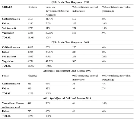
- Subsidies to the agrarian sector
- International and private investment for agrarian industry
- Consolidation on importation on corn, grains and agricultural commodities from the USA and other countries
Labor - Cheap farmers and peasants labor for Haciendas
- “Wage slavery” system
- Self-consumption and individual production
- Rural-urban migration
- Agro-industrial production, self-production
- Rural labor migration to the USA
- Abandonment of agricultural activities in Mexico
Technology - Hacienda´s technology for agro-industrialization
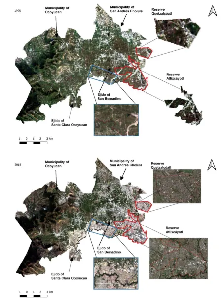
-Free distribution of farm equipment, livestock, and farm goods to ejidatarios by subsidies - Technical training from the State to ejidatarios
- Private development for agro-companies
- Distribution of farm goods from the State to small farmers - Subsidy through rural and agricultural development projects
Organization - Landlords controlled economy, commerce, transportation and labor structure.
- Rural collectives
- Family labor organization inside and outside the ejidos for survival - Ejidatarios´ labor unions
- Rural-local collectives, small producers
- Association of small producers and rural cooperatives with big agro-industries
- “Employees in their own land” through a Neo-Latifundium system based on private investment and development. Peasants and farmers produce for big companies
TABLE 1. AGRARIAN CHANGE IN MEXICO. SOURCE: MELISSA SCHUMACHER & TEODORO SCHUMACHER (2019)
264
Unable to make a living and in view of the imminent threat of their lands either being grabbed
265
by hacendados or expropriated by the Government, in 1910, farmers, workers and peasants came
266
together to resist them in what was to become the Mexican Revolution. This social movement,
267
spearheaded by farmers’ and peasants’ leaders such as Emiliano Zapata, who fought for the
268
restitution of lands to their original owners, sought for democracy and social justice under the
269
banners of “Land and Liberty” and “The land belongs to those who work it with their hands”.
270
It should be noted that the development of the Mexican Revolution was different in the North
271
guided mainly by a rural middle class, a working class, and hacendados3 that stood against the
273
political system. The government of Porfirio Díaz favored foreign companies in the development of
274
mining, railroads, livestock, and industrial agriculture in Mexican territory. In the south-center of the
275
country, the revolution had a strong ideology based on political change, social justice for peasants
276
and the restitution of ancient lands to their original owners4. In contrast to the North, hacendados did
277
not join the revolutionary forces, where peasants were incited to fight against hacendados, supported
278
by intellectuals, workers, and local leaders.
279
With the aim of fulfilling the Mexican Revolution’s land demands, the drafting of the Mexican
280
Constitution of 1917 was the basis for a National land policy through the Article 27, which guarantees:
281
"Ownership of the lands and waters within the boundaries of the national territory is vested originally in
282
the Nation, which has had, and has the right to transfer title thereof to private persons, thereby constituting
283
private property5”[40].
284
Meaning that national ownership of water and territory grants the state the right to secure tenure
285
and private property and recognized three types of tenure: public, private and communal. With the
286
stabilization of democracy, the Agrarian Reform (1920-1934) was launched as the modern land policy
287
in the wake of the Mexican Revolution. The aim of the new land policy was to enable land distribution
288
through the conversion of haciendas into a type of communal land called ejido. Widely used since
pre-289
Hispanic times, the modern ejido system grants ejidatarios the right to be communal landowners.
290
According to Assenatto & de León [41], the ejido is a communal land tenure system that ensures: the
291
right to use farmland, conduct collective activities and establish rural settlements. However, one of
292
the main drawbacks of the legal framework of ejidos was the lack of private ownership. As a type of
293
communal land, the owner of an ejido right was not able to sell it, the land was transferred to the next
294
generation or divided among family members by inheritance.
295
With the Agrarian Reform, the Agrarian Law was created as a National land policy that ensured
296
communal land tenure through ejidos and was an axiom of Mexican Revolution’s ideals during the
297
20th Century [42]. However, the beneficent intentions of a land policy based on fair distribution of
298
agricultural land did not improve the agrarian economy nor conditions for the rural population, as
299
presented in Table 1. While the ejido system did amend land tenure security for peasants and
300
indigenous people; the government subsidies did not result in a reform of labor conditions or
301
upgrading of agrarian technology for small producers.
302
Agrarian reforms continuously reshape the distribution of land, for example, the 7,000 ejidos
303
that existed in 1935, multiplied to 29,983 agrarian nuclei by 1991 at the end of agrarian distribution.
304
However, they decreased to 29, 942 on 2007, after the neoliberal socioeconomic change. [43]
305
In the 60 years of Agrarian Reform history, Warman’s[42] studies from the 20th century’s
306
agrarian census observed that 50% of Mexican territory was distributed among more than 30,000
307
ejidos for 3.5 million of ejidatarios. And yet the revolution’s promise of land justice and land rights was
308
not fulfilled, as the lack of governmental capacity to improve the agricultural economy and the
309
constant socioeconomic struggle in rural areas triggered a simultaneous migration of rural
310
inhabitants to big cities and the U.S. as a permanent feature of 20th century urban growth. This
311
situation has deteriorated further since 1992 after the liberalization of ejido land and the negotiation
312
of NAFTA6.
313
The modification and liberalization of land policies was justified by the Federal government first
314
as a necessary measure for improving tenure security and allowing “privatization of communal
315
resources”[44]; and second, to regulate informal settlements that were developed in periurban ejido
316
3 Most of the generals in the North were small and big owners of rural land, but not the famous General Pancho Villa,
who was a former hacienda worker and outlaw.
4 For example, old Altépetl communal land and territories.
5 Official translation of the Political Constitution of the United Mexican States by Carlos Pérez Vázques, in the 2005
edition by the Institute of Juridical Research, UNAM.
territories. The reform of Article 27 from the Mexican Constitution that gave private ownership to
317
ejidos had the following consequences:
318
a) Urbanization of ejidos – Many rural localities located in the outskirts of cities were
319
transformed when urban development reached former ejido land. Private ownership
320
made expropriation and selling of rural land easier.
321
b) Privatization of ejidos – Private investors bought thousands of hectares of former ejido
322
land. This action developed massive social housing projects as part of a national housing
323
policy which aimed to fulfill the needs of an increasing urban population.
324
c) Land-use change– Former productive agricultural land was transformed into massive
325
social housing and residential projects.
326
d) Migration to the United States– According to Verea [45], “the undocumented population
327
in the U.S. tripled during the NAFTA era”; in 1994 there were about 3.8 million illegal
328
Mexicans, peaking in 2007 with 12.2 million. This phenomenon is associated with the
329
introduction of subsidies for foreign farm products, against which small scale farmers
330
were not able to compete.
331
As Torres-Mazuera [7] points out, two components of land policy gave cohesion to Mexican
332
rurality: the ejido and the municipality with its town council. Both institutions have had different
333
influences in the evolution of modern land policies in Mexico, especially during the past 60 years, as
334
summarized in Table 2.
335
It is important to clarify the differences within ejido tenure systems. According to the National
336
Agrarian Law[46], due to its function as a social tenure system, the ejido used to be divided in: land
337
for human settlements close to urban population, communal lands protected by the community, and
338
agricultural plots that were the base for ejido tenure rights. Therefore, the ejidatario was granted the
339
rights to use the land, but not the legal ownership, because all ejido land is considered a National
340
good.
341
Formerly, in order to acquire ejidal rigths, the candidate should inhabit and be registered in the
342
rural community. Through a community assembly supported by a technical committee, a
343
commission evaluated the request. After three assemblies, the candidate could be recognized as an
344
ejidatario and the candidate was granted circa 8.8 hectares, varying from one geographic location to
345
other, depending on the availability of fertile land.
346
After the reforms to the Article 27, the process for recognizing private property to ejidatarios was
347
accountability of the local assemblies based on Article 56 of the National Agrarian Law. This legal
348
change transformed the legal protection of ejidos as untouchable and indissociably goods, thus
349
assemblies were the entity to grant private ownership to ejidatarios. The Certification Program for
350
Ejido Rights (PROCEDE) was the responsible Federal program for the described procedure.
351
354
TABLE 2. SUMMARY OF MEXICAN LAND POLICIES. SOURCE: MELISSA SCHUMACHER & EDUARDO GUTIÉRREZ-REYES (2019),
ADAPTED FROM WILKIE & HAMMOND (1998), WARMAN (2003), PROCURADURÍA AGRARIA
Year Promoter Land Policies Features
1853 Antonio López de Santa Anna (President)
“Primera Reforma Agraria” (First Agrarian Reform).
Legislation over public, informal and communal tenure system.
-First attempt to improve the Colonial land tenure system
1855-1861
Benito Juárez (President)
“Leyes de Reforma” (Reform Laws). Political separation of State and Church, confiscation of private and communal land, transformed into public land.
-Catholic Church possessed large portions of land, estates and properties.
- Creation of civil records.
1876 Porfirio Díaz (President)
“Enajenación de bienes” (Alienation of goods).
Transformation of small properties, communal and public land into big estates and haciendas.
-Large portions of land were in the hand of few proprietors.
-Industrialization of agriculture through
haciendas.
1910 Emiliano Zapata (Social leader)
“Plan de Ayala” (Ayala Plan). Devolution of communal land to original farmers and peasants that were grasped by
hacendados.
-Mexican Revolution, fight for democracy, land rights and land tenure.
1917 Venustiano Carranza (President)
“Ley Agraria: Artículo 27” (Agrarian Law: Article 27).
Land distribution for farmers and peasants, constitutional consolidation of
ejido tenure system.
-Land policy established in the Mexican Constitution.
-Land consolidation was a responsibility of the Federal Government.
1973 Luis Echeverría (President)
“CORETT” (Comisión para la regularización de la Tenencia de la Tierra) creation by presidential agreement.
Public organization for land tenure regularization in informal settlements over ejido and public land.
-Land management instrument focused on tenure regularization of informal settlements. -Key institution for expropriation when land ownership was granted.
1920-1934 (main period) until 1990 Federal Government
“Reforma Agraria” (Agrarian Reform).
Land distribution of ejidos, creation of Ministry of Agrarian Reform,
organization of agrarian workers union, credits for ejidatorios, and subsidies for agro-products.
Creation of CORETT (Commission for Land Tenure Regularization)
-10,000,000 hectares of land (50% of Mexican territory) distributed to farmers and peasants
as a legal right for “ejidatarios”. -Creation of 30,000 ejidos. -Decline in agricultural production.
- CORETT was the responsible institution for regularization of informal urban settlements over ejido land.
1992 Carlos Salinas de Gortari
(President)
“Liberalización del ejido” (Liberalization of ejido).
Major changes on article 27, ejido tenure system opened to private ownership.
-End of land distribution and ejidos, crisis on the rural world.
-Negotiation of NAFTA.
-Informal urban growth over ejido land. -Social programs for farmers: Oportunidades
and Procampo
2016 Enrique Peña Nieto (President)
INSU “Instituto Nacional del Suelo Sustentable” (National Institute for
Sustainable Land)
Public institution created to replace CORETT
-Mechanism for land readjustment and land regularization based on the instrument PRAH Programa para Regularizar
Asentamientos Humanos (regularization for informal settlements).
As exemplary cases of the listed features and consequences of ejido transformation into urban
355
land, there are two municipalities that stand out in particular: San Andrés Cholula and Ocoyucan,
356
former rural towns in the region of Cholula and located in the Metropolitan Area of Puebla-Tlaxcala.
357
The first municipality was part of an ambitious master plan – PROTA Plan Angelópolis– formulated
358
by Puebla’s State Government to shape urban growth through land expropriation. The second
359
municipality is exemplary of how private development and planning shapes urban growth through
360
land-use changes.
361
362
363
FIGURE 1. LOCATION MAP OF CASE STUDIES IN MEXICO. ELABORATED BY DAVID A. GONZÁLEZ-RIVAS (2019)
364
Due to its conurbation to Puebla City and the development of the commercial and residential
365
area of Lomas de Angelópolis, San Andrés Cholula, has lost a great amount of its Natural areas in
366
the past few years. Currently, 62% of the territory has been transformed into urban areas, while the
367
remaining 38% is used for agriculture. According to the latest censuses conducted by the National
368
Institute of Statistics and Geography (INEGI) [47], the number of inhabitants increased from 45,872
369
in 1995 to 80,118 in 2005. For the first time in history, San Andrés Cholula reached a population of
370
over 100,000 inhabitants in 2010. As a result, the type of population is heterogeneous, because while
371
the number of the original inhabitants still reside in the territory, the spatial growth beyond
372
municipalities’ administrative boundaries, the location of universities and the increase of services
373
and tertiary activities, has led to a population growth in which the groups of residents do not always
374
relate in terms of community or social activities.
375
Bordering to the North with San Andrés Cholula, Santa Clara Ocoyucan is located in Ocoyucan,
376
one of the 217 municipalities that conform the state of Puebla. Out of the 4,871 inhabitants registered
377
in the census of 2010 by INEGI [47], 7.31% was indigenous population and 2.42% spoke an indigenous
378
language. Santa Clara Ocoyucan’s economy is mainly dependant on agriculture and livestock,
379
however, the residential area Lomas de Angelópolis has expanded over the farm plots, exceeding the
380
policies and guidelines traced in the urban development plan of the municipality.
381
3.2 Land tenure change: PROTA/PDRA (Plan Angelópolis)
382
383
In Mexico, every planning instrument or mechanism is based on the National Planning Law[48],
384
updated in 2015. This law provides the guidelines for the elaboration of national development plans
385
and establishes different categories and planning scales that should be aligned with the National
386
Plan. Normally, this plan is valid for 6 years during every president period.
387
Other two key planning instruments are the National Urban Development Plan and the Human
388
Settlements, Spatial Planning and Urban Development Law[49] which guide spatial planning and
389
urban development.
390
The ministry responsible for supporting those key instruments is the Ministry for Agrarian Land
391
and Urban Development (SEDATU), which works with other organisms to create and modify plans.
392
municipalities are responsible for planning and regulating their territories and their plans should be
394
aligned with regional and national development plans.
395
At a regional and municipal level, urban development plans are the most important
396
implementation instrument. Thereupon, plans are useless without operative programs, especially at
397
a local level as the plans should contend with construction regulations, land uses, density, zoning
398
and cadaster included in the municipal urban development programs.
399
Such was the case for PROTA, a regional plan that managed urban growth in the metropolitan
400
area of Puebla-Tlaxcala, and its operative program was the PSDUM, a program that was main
401
guideline for local urban plans in Cholula.
402
The Metropolitan Area of Puebla-Tlaxcala is located 120 km west of Mexico City; its major urban
403
core is the City of Puebla, a former textile industry center. In 1960, the modernization of the city began
404
with federal projects in the 1960s and 1970s following the establishment of production facilities by
405
the German car manufacturer Volkswagen. This action transformed Puebla and its surroundings into
406
an important industrial hub between the capital of the country and the Port of Veracruz.
407
Despite industrial growth, no holistic urban planning existed until 1990. Due to the liberalization
408
of ejido land, Puebla’s Government created a metropolitan plan first called Programa Regional de
409
Ordenamiento Territorial Angelópolis PROTA and then updated as Programa de Desarrollo Regional
410
Angelópolis PDRA. As part of this plan, the land reserve “Reserva Territorial Atlixcáyotl-Quetzalcóatl”
411
was created through a sub-regional implementation plan Programa Sub-regional de Desarrollo Urbano
412
de los Municipios de Cuautlancingo, Puebla, San Andrés Cholula y San Pedro Cholula PSDUM. This
sub-413
regional plan managed future urban growth for several municipalities and promoted housing
414
development to fulfil immediate population needs.
415
For the creation of the land reserve, 1,092 Hectares of ejido land from the region of Cholula –
416
the municipalities of Cuautlancingo, San Pedro Cholula and San Andrés Cholula – were expropriated
417
[50][51][52]. In addition to the mentioned municipalities, the master plan included 33 other localities
418
with the purpose of generating the first integrated metropolitan development plan through the
419
PROTA [53]. Locally, the urban development plan was carried out through the PSDUM[54] in which,
420
for the first time, the urban context was considered as a whole. This plan included an
all-421
encompassing outlook for mobility systems, urban infrastructure, wastewater treatment plants,
422
peripheral ring roads and a vast ecological reserve of green belts along a – polluted – river crossing
423
the urban territory, the Atoyac. Puebla’s Governor at the time, Manuel Bartlett (1993-1999), invited
424
international architectural firms to collaborate on the re-engineering of the city and develop the plan,
425
as local bureaus did not share Bartlett’s progressive mentality and did not have the economic nor
426
human capital to compete with international firms. Among the firms involved were the North
427
American architects and urban consultants HKS Architects, Sasaki & Associates and McKinley &
428
Co.[12]. They proposed commodifying the historic center through investment in touristic
429
infrastructure and expanding the metropolitan area towards the newly created land reserve. The
430
PROTA master plan had an exclusive automobile-planning rather than an inclusive development
431
focus to assess the needs of rural and urban population. PROTA proposed a zoning land-use, retail
432
and residential areas, entertainment, and services. In addition to PROTA, the PSDUM was the
433
framework for land expropriations that had been taking place at a continuous pace since 1992. The
434
PROTA was in place until 1999 but it did not survive the subsequent two state governments, and the
435
holistic metropolitan plan was shelved.
436
The idea of an integral spatial planning was no longer addressed in the political agenda until
437
2011 with the government of Rafael Moreno Valle (2011-2017). Moreno Valle shared Bartlett’s idea of
438
attracting international investment to Puebla and providing resources to carry out iconic projects.
439
During this period, the exploitation of the land reserve for commercial and residential ends expanded
440
at an accelerated rate. The updating of PSDMU was an urban and re-engineering intervention for
441
programming urban land through hybrid zoning of mixed land-use in order to create groupings of
442
economically interesting investment projects that would generate commercial benefits. PSDMU was
443
updated five times in 1997, 1998, 2000, 2005, and 2011, but as noted by Garrido Alfonso, the creation
444
During Bartlett’s period, urban development was based on the idea of doing business through
446
benefit and profit from urban land uses. Thus, the real estate developers defined the rhythm and the
447
shape of urban growth focused on construction of gated communities, residential towers, amenities,
448
and shopping centers aimed at middle and upper-middle class consumers seeking for commodities
449
and a high-end life-style. This was the consequence of a neo-liberal trend in urban development,
450
where private developers were responsible for urban planning rather than local authorities, who
451
behaved rather flexibly in the enforcement of regulations regarding land uses [19].
452
453
4. How much ejido land was transformed into urban?
454
455
The municipalities of San Andrés Cholula and Ocoyucan are part of the Metropolitan Area of
456
Puebla-Tlaxcala, they share physical conurbation with the city of Puebla and had a largely
457
agricultural economy until the late 20th Century. In 1995, San Andrés Cholula began its urban
458
metropolization process with the implementation of the PDRA and Ocoyucan, mainly from 2010
459
when private developers bought cheap ejido land in order to push urban development. The name and
460
size of ejidos from both municipalities is presented in Table 4.
461
The ejidos from San Andrés, as part of a planning speculative strategy, detonated sprawl and
462
urbanization based on real estate market and cheap rural land for investment, as exemplified by ejidos
463
San Bernardino Tlaxcalancingo and Santa Clara Ocoyucan.
464
Nowadays both locations present a modern urban image with luxury residential areas and
465
towers, gated communities and several shopping and entertainment centers. Although Ocoyucan
466
was not considered as part of PDRA implementation and urban growth, housing market demand
467
turned the area into a new pole for residential development due to the flexibility of urban regulations
468
– a legacy of its status as a former rural municipality. Table 3 shows the population growth in our
469
case studies in order to visualize to what extent both municipalities have been developed in
470
comparison to the main urban core, Puebla, and the whole Metropolitan Area of Puebla-Tlaxcala. The
471
latest statistics are based on the National Census of 2010, Metropolitan Statistics from CONAPO [57],
472
and National Polls from 2015 [58], however it would be worthwhile monitoring the results from the
473
next National Census of 2020.
474
475
476
477
MUNICIPALITY 1990 2000 2010 2015 POPULATION GROWTH
DENSITY
San Andrés Cholula (77.182 Km2)
37,788 56,066 100,439 137,290 1990-2000:2.5% 2000-2010:5.8% 2010-2015: 7%
2171.7 pop/Km2
Ocoyucan (120.165 Km2)
17,708 23,619 25,720 28,220 1990-2000:2.9% 2000-2010: 0.8% 2010-2015: 2.0%
214 pop/Km2
Puebla (Capital) (548.889 Km2)
1,057,454 1,346,916 1,539,819 1,576,259 1990-2000:2.5% 2000-2010:1.3% 2010-2015: 0.6%
2805.34 pop/Km2
Metropolitan Area of Puebla-Tlaxcala (2,394.4 Km2)
1,776,884 2,269,995 2,728,790 2,941,989 1990-2000:2.5% 2000-2010: 1.8% 2010-2015: 1.6%
76.6 pop/Ha
478
479
480
MUNICIPALITY Ejidos before 1995 Total Hectares of Ejidos in 1995
Urban development after 1995
Total Hectares of urban development from1995 to 2018
San Andrés Cholula Ejido San Andrés Cholula
1,986.00 Land Reserve
Atlixcáyotl - PSDMU
1,222.00
Ejido San Bernardino Tlaxcalancingo
Several gated communities, high-towers and retail areas
Ocoyucan Ejido Emilio Portes Gil
3,614.50
Ejido La Pastora Ejido San Bernardino Chalchihuapan Ejido Santa Clara Ocoyucan
Lomas de
Angelópolis (gated community
developed by Grupo Proyecta)
4,204.00
Ejido Santa María Malacatepec
Ejido Santa Martha Hidalgo
Ejido Santiago Coloctzingo
TABLE 4. NAME AND SIZE OF EJIDOS IN SAN ANDRÉS CHOLULA AND OCOYUCAN. SOURCE: VII CENSO EJIDAL INEGI
481
FIGURE 2. DISTRIBUTION OF EJIDOS BELONGING TO THE MUNICIPALITIES OF SAN ANDRÉS CHOLULA AND OCOYUCAN BASED ON
482
A FALSE COLORED IMAGE LANDSAT 2O18. ELABORATED BY DAVID A. GONZÁLEZ-RIVAS (2019)
483
How much of San Andrés Cholula and Ocoyucan rural territory is now urban? As shown in
484
Table 4, data from INEGI records the exponential population growth of San Andrés Cholula and
485
Ocoyucan compared to other areas, which demonstrates that both municipalities are attractive places
486
for new incomers.
487
In order to visualize the urban growth in the case studies, we made use of satellite images of the
488
urban settlements. We used images from satellites Landsat 5 and Landsat 8 from dates corresponding
489
to summer of 1995 and 2018 to measure the urbanization of ejido and rural land and to determine the
490
total area used.
491
The digital level values of all the images were converted to Top of Atmosphere Radiance
492
(TOAR). The Dark Object Subtraction (DOS1) method in QGIS 2.18 was necessary to correct the
493
atmospheric effects. To obtain the total farmed area and urban area per year, as well as its
494
geographical location, we used a supervised classification – maximum likelihood algorithm of
495
GRASS GIS 7.4 – and categorized each of the images into four groups: cultivation area, urban area,
496
soil area and vegetation area.
497
We applied the method developed by Olofsson et al. [60] to validate the classification and
498
estimation area of each category. The method includes calculating the sample size and assigning it to
499
the categories of coverage types based on the best result of five hypothetical assignments. Moreover,
500
to assign land-use of reference coverage we performed a visual inspection of each of the sample units
501
using a set of Landsat images together with Google Earth ™ images with a difference of 3 months
502
per 2018 image. 1995 Google Earth ™ satellite images were available. Following Olofsson et al. [60],
503
after the visual inspection, we calculated the estimation area and error through pixel precision using
504
the confusion matrix relative to the confidence intervals. This procedure was followed for both
505
images from the total area of the study area, and for each of the sub-areas previously determined,
506
using a confidence interval of 95% and standard error of 0.015 for the sample size calculation.
507
Five possible "allocations" were constructed for each year, with an average of 800 samples,
508
distributed over four classes per year, based on the confusion matrix suggested by Ofosson et al.
509
(2014). As a result, we obtained for each class the total estimated area and a 95% confidence interval
510
512
513
514
Ejido Santa Clara Ocoyucan 1995
STRATA Hectares Land use
development (Overall Average)
95% confidence interval in Hectares
95% confidence interval in percentage
Cultivation area 6,665 41.70% 562 8%
Urban 1,230 7.7% 203 16%
Soil (vacant) 1,756 11% 234 13%
Vegetation 6,336 39.63% 563 9%
TOTAL 15,987 100%
Ejido Santa Clara Ocoyucan 2018
Cultivation area 4,012 25% 255 6%
Urban 4,204 26.30% 343 8%
Soil (vacant) 1,032 6.5% 264 26%
Vegetation 6,739 42.20% 383 6%
TOTAL 15,987 100%
Atlixcáyotl-Quetzalcóatl Land Reserve 1995 Strata Hectares 95% confidence interval
in Hectares
95% confidence interval in percentage
Cultivation area 811 66% 31 4%
Urban 410 33% 31 7%
TOTAL 1,222 100%
Atlixcáyotl-Quetzalcóatl Land Reserve 2018 Vacant land (former
cultivation area)
447 36% 46 10%
Urban 775 63% 46 6%
TOTAL 1,222 100%
TABLE 5. SAMPLING SIZE CALCULATION FOR THE CASE STUDIES ACCORDING TO OLOFSSON’S METHOD. SOURCE: ELABORATED
515
517
518
519
520
521
522
5. Results
523
Through the comparison of the images taken by Landsat 5 and Landsat 8 satellites over a span
524
of 23 years, we observed the land-use changes in the forest areas and agrarian zones of Ocoyucan
525
and San Andrés Cholula.
526
According to Figures 2 and 3 and Table 57, the land-uses of the aforementioned ejidos changed
527
radically. The Santa Clara Ocoyucan ejido devoted 41.7% of its territory to farming in 1995, but this
528
had decreased to 25% by 2018. Its urban area, which accounted for only 7.7% of the territory in 1995,
529
increased to 26.3% by 2018 due to the construction of the “Lomas de Angelópolis” gated-community.
530
In 1995, 33% of the land reserve Atlixcáyotl-Quetzalcóatl8 in San Andrés Cholula was classified
531
as urban and 66% as farmland. By contrast, in 2018 63% of the land reserve was classified as urban
532
while the remaining 36% of farmland changed its land-use to vacant land for development. In
533
addition, the Atoyac River was the natural border between San Andrés Cholula and the city of
534
Puebla. However, the cession of 38,100 Hectares of San Andrés Cholula’s land reserve to the city of
535
Puebla in 2014 by the Local Congress [37], changed the territory in shape and value, as the ceded
536
territory in 2019 is one of the most lucrative and expensive areas in terms of taxes and cadastral values
537
[62].
538
In Figure 2, the land reserve Atlixcáyotl-Quetzalcóatl at the moment of expropriation in 1995 is
539
indicated in blue. According to PSDUM, this land reserve shares boundaries between San Andrés
540
Cholula, San Pedro Cholula, Cuautlancingo and the conurbation with the City of Puebla. The two
541
other main ejidos from San Andrés Cholula and Ocoyucan, the ejido of San Bernardino Tlaxcalancingo
542
and the ejido of Santa Clara Ocoyucan, are delineated in red.
543
Figures 3 and 4 show the spatial development for the ejidos and rural areas in San Andrés Cholula
544
until 2018. It is striking that the land reserve is almost completely built up and developed. For
545
Ocoyucan, the ejido demarcated in red is completely urbanized by the “Lomas de Ángelópolis” gated
546
community. In the satellite image, Ocoyucan shows up as a rural municipality with small urban cores,
547
however, this municipality was not part of the PROTA or PSDUM plans, but it was progressively
548
urbanized as a crossing municipality to the city of Atlixco.
549
550
551
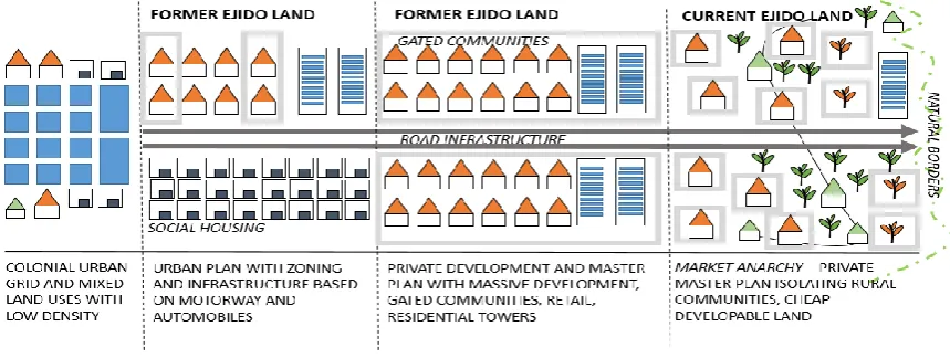
FIGURE 5: SEGRETATION AND URBANIZATION MODEL OVER FORMER EJIDO LAND. SOURCE: MELISSA SCHUMACHER (2019)
552
553
The motorway crosses the land reserve from north to south and the “Periférico9” crosses from
554
north-west to south-east the Metropolitan Area. Both the “Periférico” and the Puebla-Atlixco
555
7 In Table 5 we counted 1,222 Hectares rather than 1,092 because some selected plots correspond to the Atoyac River as
a boundary for the land reserve.