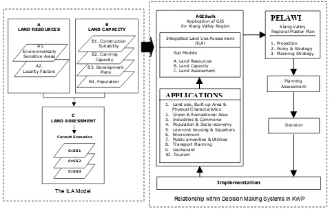
GIS based integrated planning assessment for sustainable land use development
Full text
Figure
Related documents
Finally the aims of this study to determine the indicators of evaluate of children with mathematics learning disabilities, the level of visual discrimination
Materials and Methods: The specificity of the assay was tested using reference strains of vancomycin-resistant and susceptible enterococci.. In total, 193
The use of sodium polyacrylate in concrete as a super absorbent polymer has promising potential to increase numerous concrete properties, including concrete
(B) Bar chart illustrating the relative magnitude and direction of change in transcript levels produced by microarray for the genes differentially expressed in both
Higher-level dispatch and control centres (for example, electrical grid control centre, dispatch power system centre, group control centre for several substations,
From the bar diagram it is clear that the geopolymer concrete blended with 100% GGBS shown maximum split tensile strength values at all curing periods and the values are greater
Although we found an inverse relation between participants’ HRQoL estimates (EQ-5D-5L and QoL-AD) and the severity of the AD, each participant provided HRQoL estimates for a
Densitometric parameters (such as mean lung density [MLD], standard de- viation of lung density [SD-LD], kurtosis, and skewness) de- rived from CT attenuation histograms have served
