www.ijiset.com
Site Selection of Ecotourism: A case study of Zhejiang Province
Yiyang Fang
Institute of geography and Environmental Science, Zhejiang Normal University, Jinhua, 321004, China
Abstract
In order to reduce adverse effects on the environment caused by conventional (mass) Tourism, the importance of ecotourism is becoming increasingly highlighted as this form of tourism contributes to the environmental protection and sustainable development of an area. The main objective of this study is the development of a reliable model for the identification of zone suitability for sustainable development of ecotourism, which will represent a significant support for planners in strategy development and management of ecotourism. The proposed model is based on the combined application of Geographic Information Systems (GIS) and Multi-Criteria Decision Analysis (MCDA) using Fuzzy Decision Making Trial and Evaluation Laboratory (FDEMATEL) method in order to estimate and map the suitability classes of ecotourism potentials in the study area of Zhejiang Province (China). The model has been developed by using 11 criteria grouped in 3 clusters. The application FDEMATEL method has been used for expert calculation of the weight for all clusters/criteria in relation to their impact on the development of ecotourism. The final suitability map of ecotourism development has been obtained by applying Weighted Linear Combination (WLC) and it has been designed in 3 suitability classes as: Highly Suitable (S1), Moderately Suitable (S2), Marginally Suitable (S3), and Not Suitable (NS). The proposed method and the results of this study can be used as a policy of sustainable development at all levels of public administration.
Keywords: Ecotourism, Geographic Information Systems(GIS), Multi-Criteria Decision Analysis(MCDA), Fuzzy Logic, FDEMATEL, “Zhejiang”.
1. Introduction
Tourism is now the world's largest industry, with nature tourism the fastest growing segment. People want to experience nature and the world, but should try to do so in a way that doesn't impact the natural environment. In response to this increasing appreciation of nature experiences, a new travel ethic has arisen called ecotourism.
Ecotourism in China is considered to be still in the development stages, although it is always perpetuated as well-developed by local media. It isn't particularly clear why ecotourism in China is relatively non-existent, but it has been attributed to the relatively low domestic travel
rates within China, as well as the high cost of making travel eco-friendly, and the lack of true ecotourism accommodation in China. Furthermore, the lack of true ecotourism practices, policies, and guidelines in China have recently been associated with the degradation of some natural and tourist sites. Until China is able to properly regulate, as well as increase interest in, its ecotourism industry, ecotourism in China will remain a very small and continually developing industry.
Zhejiang is a famous tourist province in China. So the problems caused by conventional tourism are more obvious than in other provinces and are more urgent to be solved. Tourism is one of the dominant industries in this province but very unbalanced-developed in different regions. Most sites cluster. These clustering spots are centered around densely populated area that indicates the large market. This may lead to overdevelopment and further deterioration of the local ecology because it may exceed the local environmental carrying capacity.
Until now, a national ecotourism framework has yet to emerge, and serious “generalization” problems of ecotourism development have appeared in China in recent years. The generalization of ecotourism provided a “golden signboard” and economic benefits to some tour operators and local governments. However, it has caused irreparable ecological damage and serious misconceptions of ecotourism by the society.
A large number of authors are warning that the development of ecotourism can only be achieved by proper planning and the involvement of local people and communities in the management system. (Stricland-Munroa and Moorea, 2013; Ramosa and Prideauxa, 2014; Wishitemi et al., 2015)
As to the analysis aim, the criteria do not have the same degree of importance, so it is necessary for the decision makers to define the proper weight coefficients (weights) for the criteria. The priority of each criterion and its impact on other criteria is primarily determined by opinions and expertise of experts (Delphi method).
This report is to identify zone suitability for sustainable development of ecotourism by applying Fuzzy logic and Weighted Linear Combination(WLC).
2. Study area and Methods
Zhejiang is an eastern coastal province of China. The changing terrain and landscape diversity made it a top tourism province of the country.
Fig. 1 the Map of the Zhejiang Province.
The province is traditionally known as the "Land of Fish and Rice". True to its name, rice is the main crop, followed by wheat; north Zhejiang is also a center of aquaculture in China, and the Zhoushan fishery is the largest fishery in the country. The main cash crops include jute and cotton, and the province also leads the provinces of China in tea production. (The renowned Longjing tea is a product of Hangzhou.) Zhejiang's towns have been known for handicraft production of goods such as silk, for which it is ranked second among the provinces. Its many market towns connect the cities with the countryside.
Zhejiang consists mostly of hills, which account for about 70% of its total area. Altitudes tend to be the highest to the south and west and the highest peak of the province, Huangmaojian Peak (1,929 meters or 6,329 feet), is located there.
Valleys and plains are found along the coastline and rivers. The north of the province lies just south of the Yangtze Delta, and consists of plains around the cities of Hangzhou,
Jiaxing, and Huzhou, where the Grand Canal of China enters from the northern border to end at Hangzhou. There are over three thousand islands along the rugged coastline of Zhejiang.
Zhejiang has a humid subtropical climate with four distinct seasons. Spring starts in March and is rainy with changeable weather. Summer, from June to September is long, hot, rainy, and humid. Fall is generally dry, warm and sunny. Winters are short but cold except in the far south. Average annual temperature is around 15 to 19 °C (59 to 66 °F), average January temperature is around 2 to 8 °C (36 to 46 °F) and average July temperature is around 27 to 30 °C (81 to 86 °F). Annual precipitation is about 1,000 to 1,900 mm (39 to 75 in). There is plenty of rainfall in early summer, and by late summer Zhejiang is directly threatened by typhoons forming in the Pacific.
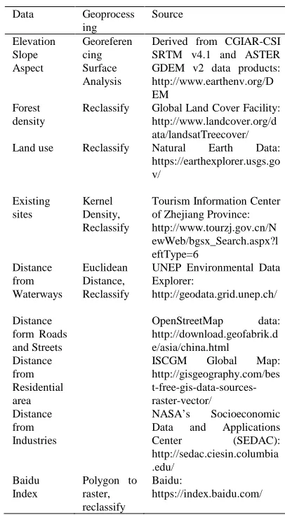
2.1 Data
Table 1: Data used and sources
Data Geoprocess
ing
Source
Elevation Georeferen cing Surface Analysis
Derived from CGIAR-CSI SRTM v4.1 and ASTER GDEM v2 data products: http://www.earthenv.org/D EM Slope Aspect Forest density
Reclassify Global Land Cover Facility: http://www.landcover.org/d ata/landsatTreecover/
Land use Reclassify Natural Earth Data:
https://earthexplorer.usgs.go v/ Existing sites Kernel Density, Reclassify
Tourism Information Center of Zhejiang Province: http://www.tourzj.gov.cn/N ewWeb/bgsx_Search.aspx?l eftType=6 Distance from Waterways Euclidean Distance, Reclassify
UNEP Environmental Data Explorer: http://geodata.grid.unep.ch/ Distance form Roads and Streets OpenStreetMap data: http://download.geofabrik.d e/asia/china.html Distance from Residential area
www.ijiset.com
2.2 Methods
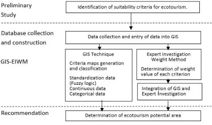
The overall objective of the paper is the development of a zonal spatial model for identifying land classes for the development of ecotourism. The formation of a network hierarchy model is an important creative phase in the process of resolving the problem because the consideration of all factors which affect the assessment of the land suitability for the development of ecotourism and their interaction is a necessary precondition for finding a proper solution. Due to the complexity of the problem, methodological hierarchical model presented in this paper is based on the GIS- MCDA structure. This approach uses the ability of GIS to manage geospatial data and MCDA flexibility to combine factual information (e.g. land use, slope, communications, etc.) with value-based information (e.g. expert opinion, standards, surveys, etc.) (Geneletti et al., 2003; Malczewski, 1999). In the process of selecting optimal solutions, a large number of factors must be included in the decision, and GIS is ideal for this type of study due to its ability to manage a large number of spatial data from different sources. On the other hand, the Multi-Criteria Decision Analysis (MCDA), in a form of FDEMATEL method, can provide adequate manipulation and evaluation of data, based on a large number of factors which may have an impact on the analysis of the defined problem(Mobaraki et al., 2014; Dhami et al., 2014; Bunruamkaew and Murayama, 2011; Kheikhah Zarkesh et al., 2011; Jeong et al., 2014). The process of combining GIS and FDEMATEL methods in order to define the zones of land suitability classes for the development of ecotourism in Zhejiang includes the following key phases shown in Fig. 2. And the manipulation model of Arcgis 10.2 is shown in Fig.3.
Fig. 2 Schematic diagram for modeling suitable ecotourism sites.
Fig. 3 The workflow of the project.
Phase 1. Preliminary study. The first step in this phase involves the identification of the problem, study area and the construction of model architecture. The second step involves the identification of criteria and clusters for assessing the suitability of land from the standpoint of ecotourism potential. The identification of the criteria is a complex and important process of grouping and defining the factors which are very important for evaluating land suitability classes for the development of ecotourism. When defining these criteria, the experts having a huge experience in the field of ecotourism, spatial planning and environmental protection participate directly.
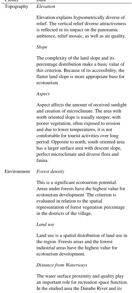
The aim of this study is to propose a reliable zonal model that can serve as a useful tool for strategic decision-making process in planning the development of ecotourism in the region of Zhejiang. Three experts with considerable experience in the field of tourism, spatial planning and environmental protection participated in the selection of the adopted criteria for zoning the suitability of the land for the development of ecotourism. Upon interviewing the experts, the collected data were processed and the aggregation of their opinions was made. On the basis of the previous studies, professional expert opinions and the natural characteristic of Zhejiang, 11 criteria were selected in this study and they are grouped into 3 clusters which are crucial for evaluating and zoning the ecotourism potential of the Zhejiang. The selected criteria with a brief description and the references of the authors who used them in similar studies are presented in Table 2.
statistical reports. The datasets in GIS are usually organized in raster format with a defined spatial resolution. By entering into GIS, each of the criteria is presented in the form of spatially defined maps, the cells of which represent the attributes with different ranges or scale values. The data used in this study have been compiled from various sources. All GIS transformation process and data modeling have been made using integrated ArcGIS 10.2 ESRI software tools (Table 2).
Table 2: Clusters and criteria for ecotourism.
Cluster Data
Topography Elevation
Elevation explains hypsometrically diverse of relief. The vertical relief diverse attractiveness is reflected in its impact on the panoramic ambience, relief mosaic, as well as air quality.
Slope
The complexity of the land slope and its percentage distribution make a basic value of this criterion. Because of its accessibility, the flatter land slope is more appropriate base for ecotourism
Aspect
Aspect affects the amount of received sunlight and creation of microclimate. The area with north oriented slope is usually steeper, with poorer vegetation, often exposed to erosion and due to lower temperatures, it is not comfortable for tourist activities over long period. Opposite to north, south oriented area has a larger surface area with descent slope, perfect microclimate and diverse flora and fauna.
Environment Forest density
This is a significant ecotourism potential. Areas under forests have the highest value for ecotourism development. The criterion is evaluated in relation to the spatial
representation of forest vegetation percentage in the districts of the village.
Land use
Land use is a spatial distribution of land use in the region. Forests areas and the lowest industrial areas have the highest value for ecotourism development.
Distance from Waterways
The water surface proximity and quality play an important role for recreation space function. In the studied area the Danube River and its tributaries have the largest hydrographic value.
Socio-economic
Distance form Roads and Streets
Roads affect the accessibility of the ecotourism area. Good interconnection of tourist values enables the creation of tourist destination.
Distance from Residential area
The proximity of populated areas plays an important role in the development of ecotourism. Privacy and distance from the city noise are attractive for eco-tourists. The proximity of urban areas
has a negative impact.
Existing Sites
New sites are supposed to be not close to existing sites to prevent competition and over depletion of resources.
Distance from Industries
This factor has a restrictive role.
Baidu Index
This is an index depicting the search volume of a certain word. It can be used to estimate how popular a place is and will be.
The map of forest density criteria (expressed as a percentage) has been calculated the settlements and the total area of the set- tlements (Table 1).
Phase 3. GIS-MCDA phase involves the standardization, weighting and summary analysis of all considered criteria and clusters in the land evaluation process from the standpoint of its suitability for the development of ecotourism. Standardization is the first step of this phase in which the criteria, presented on maps in the form of GIS layers, are transformed (reclassified) in different ways and in different forms into units that can be compared. The decision on which method will be applied depends on the nature of attributes and decision-makers. The most common method is applicable linear transformation or reduction of the scale interval, after which each raster cell (attribute), in relation to the objective of the analysis, obtains dimensionless value x i on the adopted scale. In this way a further execution of arithmetic operations is allowed(Mahdavi, A., Niknejad, M., 2014). In this study, the fuzzy logic was used in the process of data sets standardization of criteria.
www.ijiset.com
criteria do not have the same degree of significance, so it is necessary for decision makers to define the influence of certain criteria using the appropriate weights for the criteria (Fig. 4). In order to calculate the normalized weight of criteria and the final implementation of WLC method the fuzzy DEMATEL method has been used. DEMATEL method is multidisciplinary technique based
Fig. 4 The procedure for obtaining the final suitability map in GIS.
on the interpretation of complex problems in the hierarchy, and it has been used in this model to determine the interconnections between the criteria and criteria weights.
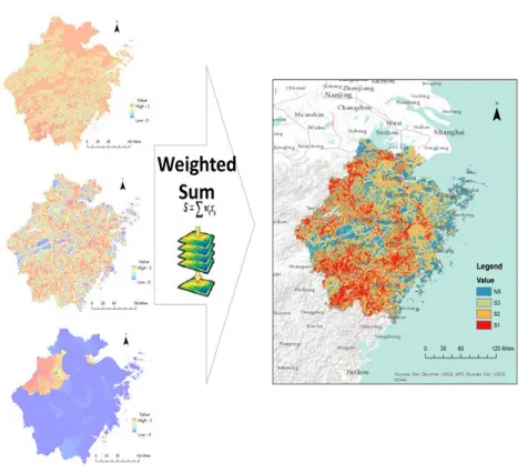
The last step in this phase is an aggregation of the final suitability map. The final suitability map is obtained by using the weighted linear combination (WLC), the numbers of cells in the raster in x and y direction. In Fig. 5, the above described method is shown. In the case of this paper, Weighted Sum is applied.
Fig. 5 The procedure for obtaining the final suitability map in GIS.
Phase 4. The final step, defining the suitability zone for the development of ecotourism, is performed on the basis of the calculated values of suitability cell index from the final suitability map. On the basis of this, it is possible to perceive the belonging to the zones of the existing ecotourism sites and to define the suitable degree ecotourism development within the zones.
3. Results
By applying geostatistical analysis of the final suitability map, suitability zones have been defined in space for the development of ecotourism shown at the level of the settlements in Zhejiang (Table 3). Affiliation to the zone of suitability for ecotourism is the basis for defining the type of ecotourism activities. By analyzing the given results more detailed ecotourism potentials of the region can be seen.
Table 3: The areas of classes from the final suitability map for ecotourism
Population Suitability index
Sustaina-blity degree
104 S1 S2 S3 NS
104km2 104km2 104km2 104km2
Hangzhou 688 3.3 43.3 6.5 4.5 B
Huzhou 596 4.4 3.5 4.3 36.5 D
Jiaxing 358 6.5 6.7 0.4 24.5 D
Jinhua 756 4.3 7.6 5.4 31.1 D
Lishui 216 6.5 14.7 36.7 9.2 C
Ningbo 596 4.3 34.3 3.3 2.2 B
Quzhou 213 0.4 3.3 6.5 26.3 D
Shaoxing 430 5.4 6.5 4.3 16.2 D
Taizhou 515 2.2 4.3 46.4 1.2 C
Wenzhou 756 15.3 0.4 3.5 21.5 A
Zhoushan 100 2.6 5.4 6.7 32.9 D
10.7% 28.3% 24.1% 44.8%
References
[1] Bunruamkaew, K., Murayama, Y., Site suitability evaluation for ecotourismusing GIS & AHP: a case study of Surat Thani Province, Thailand. Procedia Soc. Behav. Sci. 21, 2011, pp. 269–278.
[2] Dhami, I., Deng, J., Burns, R.C., Pierskalla, C., Identifying and mapping forest-based ecotourism areas in West Virginia—incorporating visitors’ preferences. Tourism Manag. 42, 2014, pp. 165–176.
[3] Geneletti, D., Beinat, E., Chung, C.J., Fabbri, A.G., Scholten, H.J., Accounting for uncertainty factors in biodiversity impact assessment: lessons from a case study. Environ. Impact Assess. Rev. 23 (4), 2003, pp. 471–487. [4] Jeong, J.S., García-Moruno, L., Hernández-Blanco, J.,
Javier Jaraíz-Cabanillas, F., An operational method to supporting siting decisions for sustainablerural second home planning in ecotourism sites. Land Use Policy 41, 2014, pp. 550–560.
[5] Kheikhah Zarkesh, M., Almasi, N., Taghizadeh, F., Ecotourism land capability evaluation using spatial multi criteria evaluation. Res. J. Appl. Sci. Eng. Technol. 3(7), 2011 pp. 693–700.
[6] Malczewski, J., GIS and Multicriteria Decision Analysis. John Wiley and Sons, New York, NY, 1999, pp. 392. [7] Mahdavi, A., Niknejad, M., Site suitability evaluation for
ecotourism using MCDM methods and GIS: Case study- Lorestan province, Iran. J. Bio. Environ. Sci. 4 (6), 2014, pp. 425–437.
[8] Mobaraki, O., Abdollahzadeh, M., Kamelifar, Z., Site suitability evaluation for ecotourism using GIS and AHP A case study of Isfahan Townships, Iran. Manag. Sci. Lett. 4, 2014, pp. 1893–1898.
[9] Ramosa, A.M., Prideauxa, B., Indigenous ecotourism in the Mayan rainforestof Palenque: empowerment issues in sustainable development. J. Sustain.Tourism 22 (3), 2014, pp. 461–479.
[10]Strickland-Munroa, J., Moorea, S., Indigenous involvement and benefits from tourism in protected areas: a study of Purnululu National Park and Warmun Community, Australia. J. Sustain. Tourism 21 (1), 2013, pp. 26–41. [11]Wishitemi, B.E.L., Momanyi, S.O., Ombati, B.G., Okello,