Back to basics:
Measuring rainfall at sea:
Part 2 - Space-borne sensors
G. D. Quartly, T. H. Guymer and M. A. Srokosz
Southampton Oceanography Centre
Weather
Back to basics:
Measuring rainfall at sea: Part 2 – Space-borne
sensors
G. D. Quartly, T. H. Guymer and M. A. Srokosz
Southampton Oceanography Centre
In our first paper (Quartlyet al. 2002) we dis-cussed the importance of measuring rainfall at sea, and the different in situtechniques avail-able. Here we examine the various satellite-based remote-sensing techniques, since only such systems can provide near-global measure-ments of rain on a frequent basis. The various techniques span the electromagnetic spectrum from microwave to infrared and visible, and also include active as well as passive sensing systems. None of the sensors measure indivi-dual raindrops, but rather the bulk properties of the rain or the storm system bearing it. Below we discuss each technique in turn.
Infrared sensors
From a fixed position 35 600 km above the equator, geostationary satellites such as Meteo-sat give frequent coverage of one face of the earth. Infrared sensors (typically operating at wavelengths between 1 and 12mm) observe the brightness of individual pixels on the earth’s surface, and from such observations determine the temperature of the emitting surface. This may often correspond to land or ocean, but when thick clouds are present the measure-ment will correspond to the cloud-top tem-peratures (see Fig. 1, back cover). The temperature at the top of deep convective clouds is typically 40 K below freezing, and thus readily distinguished from open ocean temperatures. Richards and Arkin (1981) introduced the idea of a precipitation index based on the fraction of a region covered by cloud-top temperatures below a certain thresh-old (such as 235 K (08C = 273.16 K)). This `observation’ is not of the rain itself, but of storm systems likely to bear rain.
Conse-quently, the correlation between infrared esti-mates of rain and ground-truth measurements of actual rain is only moderate when individual infrared pixels are considered; much higher correlations are obtained when rain rates are averaged over large areas, e.g. 2.58 62.58
(Ebert and Manton 1998). It was subsequently noted that the optimum threshold varied with location, the temperature being some 15 K lower in midlatitudes than the tropics (Arkin and Meisner 1987).
Geostationary satellites have an adequate resolution (4 km) directly below them, but this degrades considerably as their view approaches the earth’ s limb. Consequently, four satellites are required to cover all longitudes, and the high-latitude oceans remain unobserved. A dif-ferent sampling scenario may be achieved from an orbit only *800 km up, which takes the satellite near both poles. The lower orbit pro-vides a resolution of about 1 km, allowing more detailed images of rain systems. The disadvan-tage of such polar-orbiting satellites is that they cannot offer frequent (e.g.hourly) observations of particular locations, as the earth rotates beneath them.
A variation of this technique incorporates measurements of albedo (the reflectance of visible light by clouds) to aid in the identifica-tion of different cloud types and thus in the inference of rain rate.
Passive microwave sensors
Alternatively, one can sense rain systems in the microwave band of the electromagnetic spec-trum. In simple terms, raindrops and ice part-icles can either scatter upwelling radiation from the earth’s surface (reducing the intensity
363
reaching the space-borne sensors) or augment it through their own emissions. The net effect depends upon the microwave frequencies under consideration, the background surface type and the size and nature of the hydrome-teors.
Upwelling radiation at high microwave fre-quencies (50± 100 GHz) is scattered by raining systems, leading to a reduction in the observed `brightness temperature’ of the earth’s surface. It is, in fact, the ice particles within the cloud that are the dominant scatterers, and the number density of these tends to be much higher for terrestrial storms than for those at sea. Thus scattering techniques provide an `indirect’ measure of rainfall, with the relation-ship between observed brightness temperature and rainfall involving empirically determined coefficients that are different over land and ocean, and vary with season and climate (Wilheitet al.1991).
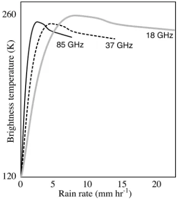
Rain estimation techniques using low micro-wave frequencies (10± 30 GHz) are based upon the absorption/emission properties of the actual raindrops. The surface of the sea has a low emissivity and provides a weak source of polarised background emissions. Raindrops, on the other hand, are much more effective emitters, and produce vertical and horizontal polarisations of similar intensity. The emissions increase with column density of raindrops. However, as the rain rates increase, scattering by the upppermost raindrops becomes signifi-cant. At yet higher rain rates, the detected emissions come from the higher (and cooler) part of the rain column. The result is that the observed brightness temperatures reach a max-imum level and then decrease (see Fig. 2). A simple inversion from brightness temperature to rain rate is thus not possible in general with observations at a single frequency, but can be achieved using a number of different frequen-cies (Ferraro and Marks 1995). Note that such a rain detection method is not applicable over land where the surface emissions are much greater.
Active microwave sensors
When we look at active microwave systems, there are again two principle techniques ±
reflectance and attenuation. The Precipitation Radar (PR) on the Tropical Rainfall Measuring Mission (TRMM) satellite is the first instrument designed to measure the reflectivity of rain from space. In essence, the technique is similar to that of land-based rain radars; short pulses are transmitted at microwave frequencies, and the time delay and strength of the echo gives the distance and intensity of the rain. The dif-ferences are that the nearest rain is about 350 km away from the sensor, and that there is no rotating dish, so scanning must be achieved by electronic steering. ThePRsurveys a swath of width 220 km at a resolution of *4.3 km (Kummerow et al. 1998). Furthermore, it is unique among the space-borne systems in that it gives information on the vertical distribution of rain, with a height resolution of 250 m. The strongest signal comes from the so-called `bright band’ of partially melted hydrometeors near the base of the cloud. Thus any calcula-tion of the reflectivity of the rain has to make allowance for the fraction of signal lost by attenuation in the bright band.
The alternative technique is to measure the fraction of the incident energy that passes right through the rain system, and hence infer the total attenuation of the rain system. In practice this means that the signal has to progress verti-cally down through the rain, reflect off the
[image:4.479.263.437.407.602.2]earth’s surface, and return up through the rain to the satellite. One of the key problems with this technique is that in order to determine the attenuation effect of rain at a location, one has to know the strength of the sea surface reflec-tance, which varies according to the prevailing wind conditions.
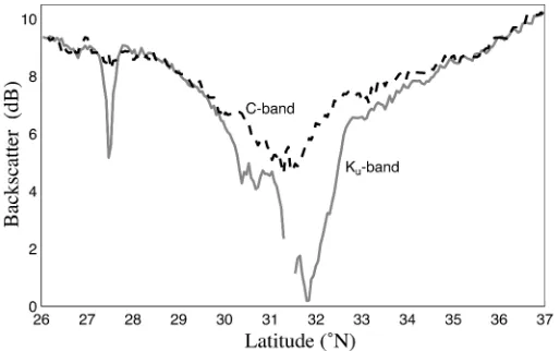
The Surface Reference Technique (SRT) relies on identifying neighbouring pixels that are unaffected by rain; if they are close it can be assumed that the sea surface roughness (principally determined by the wind) is the same at the two locations. ThePRuses this to provide a column-averaged rain rate, which can be a constraint on the recovery of informa-tion from the reflectance method. An improve-ment on this is the Dual-frequency Surface Reference Technique (DSRT), which makes use of the signal from radio pulses at a second fre-quency that is little affected by rain. This second frequency gives an independent mea-sure of the sea surface reflectance. The benefit of this method is illustrated in Fig. 3, using data from the TOPography EXperiment alti-meter (Quartly et al. 1996, 1999). The black dashed line shows the surface roughness observed by C-band (5.3 GHz), but rescaled to show the value to be expected at Ku-band
(13.6 GHz). The actual Ku-band observations,
shown by the solid grey line, indicate two regions (27.48N and 30± 348N) where there is an additional effect of attenuation by rain-drops, causing a discrepancy between the two
lines. Both theSRTand theDSRTare sensitive to the attenuation in the bright band and, in order to infer rain rate, require information on the height of the rain column. This could be acquired from coincident passive microwave sensors (Wilheitet al. 1991).
Production of global climatologies
The various techniques outlined above can be used to provide global climatologies as illu-strated in Fig. 4 (inside front cover). All sen-sors produce roughly the same geographical patterns ± showing the intertropical and South Pacific convergence zones, as well as midlati-tude storm tracks ± however, the rain magni-tude estimates for each region vary between techniques. The Global Precipitation Climatol-ogy Project is a major international initiative to combine the data from different sensors. To date it has concentrated on those datasets of long standing ± terrestrial raingauges, infrared measurements from geostationary satellites and passive microwave measurements from the Special Sensor Microwave/Imager instruments. The TRMM satellite, launched in 1997, brings a number of dedicated sensors to bear on the task, albeit just in tropical latitudes. The suite of instruments on board provide rainfall estimates through a number of active and passive microwave techniques, but to date climatologies based on these differ by up to 30% (Kummerowet al. 2000).
Fig. 3 Section of surface reflectivity across a typhoon in the North Pacific (from Quartlyet al. 1996). The Ku-band
values are affected by both changes of the sea surface and attenuation by atmospheric liquid water; C-band values (shown after an empirical rescale) reflect only changes of the sea surface.
365
[image:5.479.104.361.450.611.2]One of the continuing challenges is to understand better the assumptions and errors in each of the techniques discussed above, especially noting that some will vary regionally according to the typical size of active rain cells and the relative occurrence of convective and stratiform systems. In high latitudes there is also the need to record accurately the precipita-tion occurring as hail or snow, which is not detected well by some techniques. The dis-agreements between the various climatologies are greatest in the mid and high latitudes, with even some using the same raw data differing by more than a factor of two according to the assumptions used (Adleret al. 2001).
The latest generation of global forecasting models contain microphysical schemes that parametrize cloud drops and rainfall. One chal-lenge is to develop a model that can assimilate rainfall observations. The other challenge, since rain varies on such short spatial and tem-poral scales, is to make sufficient measure-ments to sample all the major rain events. This is being addressed by the Global Precipitation Mission (Flaminget al. 2001) which proposes to have an accurate radar in a polar orbit, plus a number of subsidiary `drones’ improving the sampling through lower-cost passive micro-wave sensors.
References
Adler, R. F., Kidd, C., Petty, G., Morissey, M. and Goodman, H. M. (2001) Intercomparison of global precipitation products: The third precipita-tion intercomparison project (PIP-3). Bull. Am. Meteorol. Soc.,82, pp. 1377± 1396
Arkin, P. A. and Meisner, B. N. (1987) The relation-ship between large-scale convective rainfall and cold cloud over the western hemisphere during 1982± 1984.Mon. Wea. Rev.,115, pp. 51± 74 Ebert, E. E. and Manton, M. J. (1998) Performance
of satellite rainfall estimation algorithms during TOGA COARE.J. Atmos. Sci.,55, pp. 1537± 1557
Ferraro, R. R. and Marks, G. F. (1995) The devel-opment of SSM/I rain-rate retrieval algorithms using ground-based radar measurements. J. Atmos. Oceanic Technol.,12, pp. 755± 770
Flaming, G. M., Adams, W. J., Neeck, S. P. and Smith, E. A. (2001) Planning for Global Precipi-tation Measurement. In: Proceedings of IGARSS
2001, 13± 17 July 2001, Sydney
Huffman, G. J., Adler, R. F., Arkin, P., Chang, A., Ferraro, R., Gruber, A., Janowiak, J., McNab, A.,
Rudolf, B. and Schneider, U. (1997) The Global Precipitation Climatology Project (GPCP) com-bined precipitation dataset. Bull. Am. Meteorol. Soc.,78, pp. 5± 20
Kummerow, C., Barnes, W., Kozu, T., Shiue, J. and Simpson, J. (1998) The Tropical Rainfall Measur-ing Mission (TRMM) sensor package. J. Atmos. Oceanic Technol.,15, pp. 809± 817
Kummerow, C., Simpson, J., Thiele, O. Barnes, W., Chang, A. T. C. and co-authors (2000) The status of the Tropical Rainfall Measuring Mission (TRMM) after two years in orbit.J. Appl. Meteorol., 39, pp.1965± 1982
Quartly, G. D., Guymer, T. H. and Srokosz, M. A. (1996) The effects of rain on Topex radar alti-meter data. J. Atmos. Oceanic Technol., 13, pp. 1209-1229
Quartly, G. D., Srokosz, M. A. and Guymer, T. H. (1999) Global precipitation statistics from dual-frequencyTOPEXaltimetry.J. Geophys. Res.,104, pp. 31 489± 31 516
Quartly, G. D., Guymer, T. H. and Birch, K. G. (2002) Back to basics: Measuring rainfall at sea: Part 1 ± In situsensors,Weather,57, pp. 315± 320
Richards, F. and Arkin, P. A. (1981) On the relation-ship between satellite-observed cloud cover and precipitation. Mon. Wea. Rev., 109, pp. 1081± 1093
Spencer, R. W., Goodman, H. M. and Hood, R. E. (1989) Precipitation retrieval over land and ocean with the SSM/I: Identification and characteristics of the scattering signal.J. Atmos. Oceanic Technol., 6, pp. 254± 273
Wilheit, T. T., Chang, A. T. C. and Chiu, L. S. (1991) Retrieval of monthly rainfall indices from microwave radiometric measurements using prob-ability distribution functions. J. Atmos. Oceanic Technol.,8, pp. 118± 136
Correspondence to: Dr G. D. Quartly, Southampton Oceanography Centre, Empress Dock, Southamp-ton, Hampshire SO14 3ZH. e-mail: gdq@soc. soton.ac.uk
#Royal Meteorological Society, 2002. doi:10.1256/wea.198.01
Books received
The following book was received byWeather. A full review will not be published but some details are given below.
Die Entwicklung der meteorologischen Dienste in Deutschland, by Klaus Wege, published by Deutscher Wetterdienst (DWD), 2002, 366 pp.,
ISSN0943 9862,ISBN3 88148 381 0, is Volume 5 in theDWD series, Geschichte der Meteorologie in
Deutschland (History of meteorology in
Germany), and is devoted to the development of meteorological services in Germany.
Weather Vol. 57 October 2002