Determination of the optimal density of the forest road
network
Tihomir Krumov*
Department of Technology and Mechanization in Forestry, Faculty of Forestry, University of Forestry, Sofia, Bulgaria
*Corresponding author: [email protected]
Citation: Krumov T. (2019): Determination of the optimal density of the forest road network. J. For. Sci., 65: 438–444.
Abstract:The forest road network is invariably linked to forestry and logging, as it transports logging products and products needed for forestry activities. Constructing and maintaining it in good condition are essential. In view of the economic situation in the country and the financial difficulties faced by forest holdings in the construction and main-tenance of the forest road network, it is necessary to determine the optimal hauling distance and the optimal density of the primary forest road network. The analysis of the forest road network in the territory of the State Educational Experimental Forestry Enterprise “Georgi Avramov”, Yundola village, showed that the density of the primary forest road network is several times higher than the national average, namely 20.31 m'·ha–1, yet it does not reach the optimal road network density calculated at the farm, of 30.9 m'·ha–1, at a hauling distance of 323.15 m.
Keywords: forestry; timber transport; export; transportation; transportation costs; cost; logging
A characteristic feature of logging activities in for-est management is that it is dominated by transport operations related to the transportation, hauling of timber from logging site through temporary ware-houses and/or cargo points to consumer centres (Jekov 2003).
Roads are therefore of paramount importance in forestry (Hristov 1982; Marinov 2013).
In forest areas, timber transport is carried out on permanent or temporary roads forming a forest road network (Molova 2002).
It satisfies not only logging but also other areas of people’s lives (tourism, social activities, etc.) (Tra-janovet et al. 2015).
The forest road network is subjected to several phases of work (Ryan et al. 2004), including the plan-ning, design, construction and maintenance of roads. When planning and constructing forest roads, it is necessary to take into account the physical,
eco-nomic and environmental characteristics of the area (Akay 2006).
This is required because the density of the forest road network depends on a number of factors: con-figuration and slope of the terrain, type of felling and the way the plantations are restored, amount of tim-ber, yield per unit area, duration of logging, the type, quality and value of timber harvested from the plan-tations, investments available for the construction of forest roads, etc. (Khristov 1982; Najafi 2008; Naghdi et al. 2009). The more severe the terrain, the higher the cost of constructing forest roads. There-fore, the density of the forest road network in the mountainous and hilly woodlands is usually lower. This, of course, adversely affects the intensity of the forestry.
invest-0 475 95invest-0 19invest-0invest-0 285invest-0 38invest-0invest-0 m
N ments are, the greater is the density of the forest
road network and the greater the cost of maintain-ing it in good order and condition (Hristov 1982). On the other hand, the cost of transporting wood is reduced and better conditions are created for its more complete and rational use (Hristov 1982; Molova 2002).
The optimal road density is an important factor that helps forest engineers optimize harvesting costs by using an appropriate forest road network (Ghaffarian et al. 2003). There is a direct link between the hauling distance and the distance be-tween roads (Tan 1992). The density of the prima-ry forest road network is more important, because the more densely its highways and branches are located, the shorter the distances in the transpor-tation and hauling of wood and, accordingly, the lower the costs of its transportation from the cut-ting sites to the consumer centres (Mostafanejad 1995; Eghtesadi et al. 2002; Naghdi et al. 2005; Eghtesadi 2008; Ghaffarian, Sobhani 2008)
In view of the above citation, the purpose of the study is to propose an approach to optimizing the density of the forest road network at the State Edu-cational Experimental Forestry Enterprise “Georgi Avramov”, Yundola village. The density
determina-tion will be justified on the basis of optimizadetermina-tion of the costs of haulage and transportation and the cost of construction, repair and maintenance of forest roads corresponding to one cubic meter of timber harvested and transported through the for-est road network.
MAteriAl AnD MethoDs object
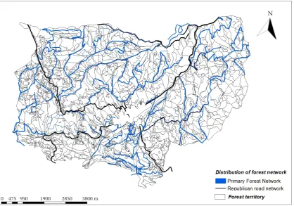
The object of the present study is the forest road network in the territory of the Educational Experi-mental Forestry Enterprise “GS Avramov”, Yundola village, Pazardzhik district (Fig. 1). The territory is located partly on the slopes of the Rhodope Moun-tains and Rila Mountain. The forests at the State Enterprise “Avramov” occupy 5131.6 ha, with affor-estation over 94.5%.
By its nature, the relief of the enterprise is typi-cally mountainous. The higher parts of the ridges are more gentle, the tops are rounded and the slopes smaller.
[image:2.595.90.509.445.738.2]The distribution of the timber production area according to the slopes of the terrains on which it
is located is presented in Table 1. It shows that the major part (53.2%) of the area is located in slop-ing terrains (11°‒20°), and 37.4% of the area are in a steep terrain. The very steep terrain covers only 2.9% of the timber production area. This largely de-fines the holding as a favourable terrain for forestry activities – felling, afforestation, road construction and others (LUP 2018).
The prevailing part of the timber production area of the farm is located on shady exposure – 55.8%, with the prevailing northern one – 19.5%. Sunny exposure accounts for 44.1%, with the largest part located on southern slopes – 14.2% (Table 2). The majority of shady exposures require additional means of maintaining the road network, as mois-ture retention is expected to further impair its condition.
Methods
Roads of different purpose and economic impor-tance are located in the territory of the holding. The inventory of the existing forest road network is made on the basis of the following main points:
(i) Determining the length of roads relevant to for-est management.
(ii) Determining the length of roads available within the holding provided that both tractor and en-gine gravitate towards them.
Taking into account the total timber production area, the density, expressed in linear meters, per hectare of timber production area (Formula 1) is as follows:
d = L/S (m'·ha–1) (1)
where:
d – density of the highway network,
L – length of the forest-road network,
S – area covered by roads.
Roads for transportation are surface roads that connect the intersections to temporary warehouses and/or loading points. They pass through the slopes and gullies at the enterprise. These paths are char-acterized by straight and inverse slopes and sharp curves. They are suitable for use only during some seasons of the year, so their length and condition were not the subject of the study.
The use of up-to-date and effective geospatial data visualization software programs enables a more in-depth analysis of the forest road network (Janusz, Łuczkowski 2017). To get a general idea of the location of the forest road network on the farm, a map was developed using the ArcGIS (ESRI).
For the determination of the cost of hauling 1 m3
of wood to different distances of transportation, the sum of average costs, complex costs and the cost of making roads is used.
The methods of descriptive statistics were used to determine the cost of hauling 1 m3 of wood. As
concerns the wood transport from the clearing to the road, in determining the basic numerical char-acteristics of the parameters (Formula 2) (Statkov 1975) it is necessary to modify the cost of transport depending on the export. The regression equation will then be used to determine the coefficients of the regression Formula:
Y = А + В × х (EUR·m–3) (2)
where:
Y – cost of extracted per 1 m3 of wood (EUR),
[image:3.595.66.527.114.172.2]x – perpendicular export distance (km), Table 1. Distribution of wood production area by slope of the terrain (LUP 2018)
Grades of slope (0°–4°)Equal Small inclination (5°–10°) (11°–20°)Tilted (21°–30°)Steep Very steep (30°) Total
Area (ha) 21.6 292.4 2,557.7 1,795.1 139.2 4,806
Percentage (%) 0.4 6.1 53.2 37.4 2.9 100
Table 2. Distribution of timber production area by terrain (LUP 2018)
Exposure Shady (N, NE, NW, E) Sunny (SE, SW, W, S) Total
Area (ha) 2,683.6 2,122.4 4,806
[image:3.595.66.526.208.252.2]A, B – coefficients that depend on the type of vehicles used and the technology, the configuration and slope of the terrain, etc., for the additional cost of transporting 1 m3 of timber transported over a distance of 1 m (coefficient B – we need them to calculate the optimal export distance).
In order to find the values of the coefficients A and B, we need to know the cost of exporting 1 m3
of wood for the different export distances.
In order to find the values of coefficients A and B, we need to know the cost of hauling 1 m3 of wood
to different hauling distances.
Determination of optimal export distances
To calculate an optimal hauling distance, the technical parameters and data available for the gravel path will be used.
Costs of the construction, repair and maintenance of 1 km of forest road network are calculated on the basis of averaged values for these activities obtained by conducting a study of the actual announced pa-rameters in the public procurement of the official and completely free access ‒ Public Procurement Portal (PPP). The depreciation period for roads with similar pavement is 50 years.
The total cost of the construction, repair and main-tenance of 1 km of gravel road network with gravel pavement is determined by the following Formula (3):
b = b1 + b2 + b3 (3)
where:
b1 – cost of construction,
b2 –repair costs,
b3– maintenance costs.
The cost of construction 1 km times in 1 year . For this purpose we will use the Formula (4):
1 1 . I пер b b a
(EUR
·
km–1) (4)where:
b1 – cost of construction,
anep. – depreciation period.
Therefore, the Formula (5) will take the following form:
b = 1
1 . I пер b b a
+ b2 + b3 (5)
The well-known formula of Hristov and Statkov (Hristov, Statkov 1978) will be used to
deter-mine the cost of constructing and maintaining 1 km of gravelled forest road:
100
0.35
b a
B V
(m) (6)
where:
a – optimum export distance recorded on the road with-out taking into account the slope of the terrain (m),
b – cost of construction,
B – export value per 1 m3 (EUR·m–3),
V – volume of timber exported per year from an area of 100 ha (m3).
Determination of the optimal density of the PMF – d
Based on the optimal distances in timber haul-age, the optimal density of the forest road network
(PMF – d) corresponding to a unit of forest area
(1 or 100 ha) can also be determined. If the most eco-nomical average perpendicular distance at haulage is
x, then the width of the working field will be a and its area corresponding to 1 km from the highway will be 1,000 a or (Formula 7):
2,500 1,000 а 10,000
d x
(hа) (7)
The density of the primary forest road network expressed in meters per hectare will then be deter-mined by the following Formula (8):
1,000
10,000 1,000
10,000a
d
a
(m
·
hа–1) (8)results AnD AnAlysis
After an in-depth analysis of the available map ma-terials (on paper and digital models) with the help of the ArcGis (10.0, ESRI) it was concluded that the UOGS forest road network has undergone signifi-cant development and is 136.1 km long (Table 3).
Roads on the farm are of different layout, category and purpose. Using the tools of the software program, a visual representation of the forest road network is presented, through property and floor selection.
Part of the following motorways is located in the territory of the surveyed area:
(i) Velingrad-Yundola-Yakoruda, 9,500 km long; (ii) Yundola-Belmeken, 8,700 km long;
(iii) Yundola-Belovo, 5,600 km long;
Applying Formula 1, it is established that the ex-isting car network at the enterprise is well
devel-1,000
10,000 1,000
10,000a
d
a
oped. The current saturation of the roads for the transportation of timber is 26.53 m'·ha–1 and does
not belong to the forestry enterprise. The location of these roads is such that it favours the proper ab-sorption of the section.
The area identified by a survey is 136,100 km of primary forest road network. This represents 20.31 m'·ha–1. The most important of them are:
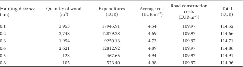
Sta-rina-Chelebiytsa, Chelebiytsa-Sechenitsi, etc. After a study of the annual use for 2018 and an analysis of the costs depending on the hauling dis-tance, the cost of hauling 1 m3 of wood from the
felling site to the highway was determined. The data are presented in Table 4.
From Table 4 it follows that the cost of 1 m3 of
timber extracted increases with the increase in hauling distances.
Using the data on hauling distances, the quan-tities of timber extracted and the cost of 1 m3 of
timber extracted, we determine the coefficients A
and B, using the regression analysis methodology and the least-squares method from which we ob-tain (Fig. 2).
Following the graphical representation of the data in Table 4 and statistical processing, the following re-gression equation according to Formula 2 is derived:
y = 1.7468 × х + 8.7628 (9)
The data shows that R2 = 0.962, ie 96.2% of the
change in Y is due to the factor x and is described by the linear model. The remaining 3.8% are due to unmanageable factors.
From Formula (9) it can be concluded that the additional cost of transporting 1 m3 of wood hauled
to a distance of 1 m is 0.89 EUR.
[image:5.595.69.533.113.228.2]Based on the average processing of data obtained from the Public Procurement Portal (POP) on construction costs (10997.44 EUR per km), repair Table 3. Density of the forest road network (area – 5,131.6 ha, d.f. – durable flooring)
Forest-road network
National Road Network Forest-road network on the territory of experimental forestry enterprise
Common
forest-road network Ratio
Length
(km) (m·haDensity–1) Length(km) (m·haDensity–1) Length(km) (m·haDensity–1)
with/ without
d.f.
National Forest Network/Forest Road Network
with d.f. 23.8 4.6 8.1 1.6 31.9 6.22
0.31 0.21
without d.f 0.0 0.0 104.2 20.3 104.2 20.31
Total 23.8 4.6 112.3 21.9 136.1 26.53
Table 4. Haulagevalue at UGSD Yundola for 2018
Hauling distance
(km) Quantity of wood(m3) Expenditures(EUR) Average cost(EUR·m–3)
Road construction costs (EUR·m–1)
Total (EUR)
0.1 3,953 17945.91 4.54 109.97 114.52
0.2 2,748 12879.28 4.69 109.97 114.66
0.3 1,954 9250.13 4.73 109.97 114.71
0.4 2,621 12812.92 4.89 109.97 114.86
0.5 123 467.65 4.94 109.97 114.91
[image:5.595.306.527.425.563.2]0.6 105 523.40 4.98 109.97 114.96
Fig. 2. Graphical presentation of the change in timber transport costs y= 1.7468x+ 8.7628
R² = 0.962
8.800 9.000 9.200 9.400 9.600 9.800 10.000
0 0.1 0.2 0.3 0.4 0.5 0.6 0.7
Average cost
(EUR·m
–3)
Removal distance (km)
[image:5.595.64.532.628.757.2][383.63 EUR (0.383 EUR·m'–1)] and maintenance
[255.75 EUR (0.255 EUR·m'–1)] Formulas 3 and 4 are
applied.
In view of the recent practice of forest road con-struction, namely that they are constructed with the pavement of coarse stone fractions (gravel), it is assumed that the depreciation period in the cal-culation of the total cost of the newly constructed roads is a_ (per.) = 50 years.
Substituting Formula 6, the total cost of con-structing and maintaining 1 km of gravel road is 859.34 EUR per km.
From the reference for 2018, 13 503 m3 of timber
was extracted from the whole territory of the SLS (5131.6 ha), therefore the volume of extracted tim-ber per 100 ha of logging area is as follows:
V = 263.13 m3/100 hа.
Therefore, by substituting the optimal hauling distance in Formula (6) and taking into account the gravel road, without taking into account the slope of the terrain, we can assume:
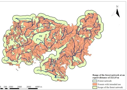
а
= 323.15 m.Using the basic tools (“buffer”) of the ArcGis pro-gram, a map is drawn up showing the range of the forest road network at an optimal hauling distance of 323.15 m.
Fig. 3 shows that the forest road network covers more than 95% of the logging compartments and subdivisions intended for use.
After determining the optimal distances for tim-ber hauling, the optimal density of the forest road network corresponding to a unit of forest area (1 or 100 ha) is also determined. Substituting the data ob-tained from Formula 6 to Formula 8, it is found that the density of the primary forest road network, ex-pressed in meters per hectare, is 30.9 m
·
ha–1.DisCussion
Based on the calculations done, the following con-clusions can be drawn: (i) It has been established that the density of the existing road network of “G. St. Avramov” training forest enterprise amounts to 26.53 m
·
ha–1, including the republic roads.(ii) The analysis of the density of the forest road net-work shows that the primary forest road netnet-work
0 500 1000 2000 3000 4000 m
[image:6.595.91.509.92.388.2]N
(20.31 m'·ha–1) is very well developed compared to
the average for the country (7.9 m'·ha–1). (iii) It is
esti-mated that the optimum distance in 2018 is 323.15 m. (iv) Following the application of GIS software, it is established that over 95% of the projected log-ging sites are within the optimal hauling distance. (v) On the basis of a survey it was found that the op-timal density of the primary forest road network is 30.9 m·ha–1 , which proves that the available 20.31 m·ha–1
forest road network approximates the optimum for the forestry enterprise at Yundola.
Acknowledgement
The present study has initiated and implemented with the support of the National Science Program "Young Scientists and Postdoctoral Students". We express our gratitude for the concern to the young researchers, scientists and professors of Bulgaria.
references
Akay A. (2006): Minimizing total costs of forest roads with computer-aided design model. Academy Proceedings in Engineering Sciences, 31: 621–633.
Eghtesadi A., Sobhani H., Rafatnia N. (2002): Study of timber transportation in the Vaz research forest. Iranian Journal of Research and Construction, 12: 23–34.
Eghtesadi A. (2008): Evaluation of wood productivity rate in primary and secondary transportation in Nekachub region. Iranian Journal Forestry Poplar Research, 16: 274–291. Ghaffarian M.R., Sobhani H. (2008): Optimum road spacing
of ground based skidding operations in Nowshahr, Iran. Caspian Journal of Enviromental Science, 6: 105–112. Hristov S. (1982): Forest transport. Zemizdat-Sofia: 7–15. Hristov S., Statkov N. (1978): Optimal road network density
in Bulgaria Zemizdat-Sofia: 141–154.
Janusz G., Łuczkowski B. (2017): GIS maps and analysis in designing forest road system on mountainous areas.
Elec-tronic Journal of Polish Agricultural Universities (EJPAU), 20. Available at http://www.ejpau.media.pl/volume20/ issue4/art-14.html
Jekov G. (2003): Concept for Analysis of the Forestry Net-work and the Unprocessed Forest Exploitation Area in the Republic of Bulgaria. Sofia, University of Forestry: 5–10. LUP (2018): Forest management plan of Training and
Experi-mental Forest Range “G. St. Avramov”: 25–68.
Marinov K. (2013): Mechanization of forest activities. Sofia, University of Forestry: 7–15.
Molova N. (2002): Forest road. Sofia, University of Forestry: 5–21.
Mostafanehad A. (1995): Study of cost production of skidder Timberjack 450C and optimal length of skid trails. [Master Thesis.] Tehran, Tehran University.
Naghdi R., Mohammadi S. (2009): Optimal Forest Road Density Based on Skidding and Road Construction Costs in Iranian Caspian Forests. Caspian Journal of Enviromental Science, 7: 79–86.
Naghdi R., Rafatnia N., Sobhani H., Jalali G.H., Hosseini S.M. (2005): A Survey of the Efficiency of Timberjack 450C Wheeled Skidder in Sheared Forests. Journal of Natural Resources, 57: 657–687.
Najafi A., Sobhani H., Saeed A., Makhdom M., Mohajer M.M. (2008): Planning and assessment of alternative forest road and skidding networks. Croatian Journal of Forestry Engeneering, 29: 63–73.
Ryan T., Phillips H., Ramsay J., Dempsey J., Forest Road Manual (2004): Guidelines for the design, construction and management of forest roads. Dublin, COFORD, National Council for Forest Research and Development: 170. Statkov N. (1975): Status and prospects for development of
the logging industry in Bulgaria. Zemizdat-Sofia: 57–60. Tan J. (1999): Locating forest roads by a spatial and heuristic
procedure using microcomputers. Journal of Forest Engi-neering, 10: 91–100.
Trajanov Z., Nestorovski L., Trajkov P. (2015): Develop-ment and perspective of forest road infrastructure in the Republic of Macedonia. Belgrade, Glasnik Sumarskog fakulteta: 141–148.