ISSN: 2334-2986 (Print), 2334-2994 (Online) Copyright © The Author(s). All Rights Reserved. Published by American Research Institute for Policy Development DOI: 10.15640/jea.v4n2a1 URL: https://doi.org/10.15640/jea.v4n2a1
Urban Evacuation Tsunamis: Guidelines for Urban Design
Leonel Ramos Santibáñez1
Abstract
Earthquakes and tsunamis are the main natural agents of urban change and directly affect the sustainable development of cities. Buildings must be becoming stronger to withstand the seismic energy released during an earthquake and coastal cities at risk of tsunami should be better prepared to facilitate the process of evacuation of people at high and safe areas in the shortest time possible before the arrival of the first waves.During SATREPS / JICA 2012-15 "Tsunami Reserch Project", was worked with Dr. Hitomi Murakami of Japan, in the application of surveys in Chilean cities affected by earthquakes and tsunamis of 2010 and 2014 and Japanese cities affected by the earthquake and Tohoku tsunami of 2011with the aim to understand the behavior of the population during a tsunami evacuation and visualize the response of urban structures, especially evacuation routes and safe areas.Coastal cities should facilitate processes are tsunami evacuation as fast, safe and efficient, so that the population is made shelter in the shortest possible time previously established locations with the minimum equipment to support the emergency.These guidelines proposes to incorporate urban design in planning coastal cities values of urban resilience to earthquakes and tsunamis and minimum standards to ensure that future threats, the population will be safer and better prepared to face a new urban tsunami evacuation; this is one of the main tasks to prevent future disasters.
Keywords: earthquake, tsunami, Evacuation Routes, Safe place, recilience.
1. Introduction
Earthquakes and tsunamis are still one of the main natural events that generate more human lost and significant economic damages on countries that are periodically submitted to these risks.Last two greatest earthquakes and tsunamis, on 2010 in Chile and 2011 in Japan, made clear both strengths and weaknesses that existed in that time, from the point of view of the response that buildings had in facing earthquakes and at the moment of evacuation of the population at the moment of a tsunami. In both countries, a strict seismic regulation permitted that structures of buildings and urban infrastructures had, in general, a proper seismic behavior, which allowed to save human lives and avoid total paralyzation of affected cities; nevertheless, at the moment of evacuation due to tsunamis, weaknesses at the coastal areas were detected, in both urban design, which facilitated the quick evacuation of people to higher and safer ground zones, and also the fact that population evacuated slowly, or simply did not evacuate at all.
Another factor that affected evacuation was the overuse of automobiles which caused enormous traffic jams on escape routes, inducing chaos on people that evacuated on foot. Coastal cities with tsunami risks must consider, in their urban planning, the differentiated distribution of the low areas under risk of flooding, and the safe areas emplaced over the mark of 30 meters above sea level. Uses for lower areas could be ports, airports, non-contaminant industries, commercial and office areas, tourism areas and mitigation coastal parks. In the case of higher areas over the mark of 30 meters, residential zones, schools, hospitals, fire departments, town halls, culture and tourism (Table 3).
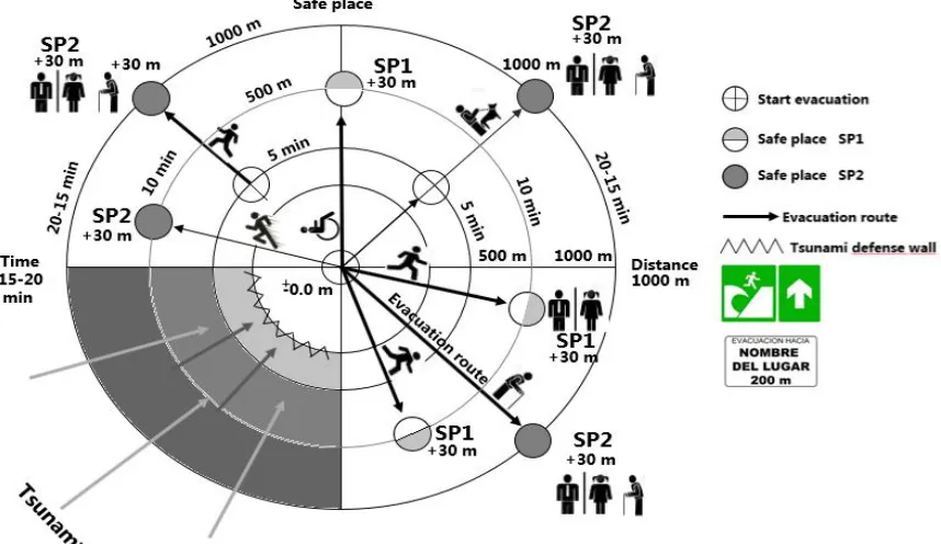
Regarding the design of the evacuation plan due to tsunami, it must be considered as a priority the time that people need (elderly, sick, disabled, children and adults) to move from a determined point in a risk zone, to a higher and safer place. Once an earthquake is finished people should be in a secure place in no more than 15 to 20 minutes. The faster the process, the greater will be the success of the evacuation (Fig.2).
Another important aspect is to define a micro zoning of the major area of flooding, in order to define more accurately the characteristics of each place in relationship with the population’s density, the closer escape routes and the access of secure places to evacuate. The need to have better designed coastal cities that allow and facilitate processes of evacuation due to tsunamis, are still a priority need and is a developing task that this guide pretends to contribute.
2. Urban evacuation due to tsunamis in coastal cities
Coastal cities with tsunami risk must avoid human casualties and material damages to facilitate both urban and emotional recovery of the population after being affected by a tsunami. A city resilient towards tsunamis would have a more sustainable development in time, allowing a quick recovery after a disaster and a sustained development of its economy, and would also be more efficient in maintaining works and productivity, which are essentials in a recovery process. It is important that these coastal cities keep the patrimonial memories alive, which will allow the strengthening of the identity of the population and have in mind the “tsunami history” that the city has experienced through time (Fig.1).
Table 1: Time to start evacuation in tsunamis 2010 and 2014 in Chile. Study surveys SATREPS/JICA, L. Ramos & H. Murakami 2014
Table 2: Rating evacuation routes in tsunami 2010 in Talcahuano and means of transport for evacuation in Talcahuano city. Study surveys in Talcahuano, SATREPS/JICA, L.Ramos & H. Murakami 2014.
Figure 1: Coastal cities resilient to tsunamis.
Source:Author
Coastal cities resilient to tsunamis must consider, in their urban planning, a difference in the permitted uses, in lower and flooding zones should be placed ports, airports, non-polluting industries, markets and business offices, touristic activities and mitigation parks with tall, compact buildings, and a route structure that allow evacuation to safe zones; and in higher grounds, over 30 meters above sea level, residential areas, schools, universities, hospitals, fire departments, town halls, cultural and touristic areas would be placed (Table 3).
Table 3: Urban uses in coastal cities with risk of tsunamis, Usos urbanos en ciudades con riesgo de
tsunamis.
Uses low zone Tsunami risks.
Coastalmitigationworks
Ports/Airport
Uses high zone +30m
Housing
Nonpollutingindustry Schools/Universities
Commerce/offices Hospitals/firemen
Tourism Culture/ Municipality
Parksmitigation Tourism
Evacuation route Safe places
Source: Author
2.1 Horizontal evacuation on hills
If the city has close hills with a minimum height of 30 meters above sea level and no more than 1 kilometer from the most unfavorable point of the coast, horizontal evacuation on hills is usually the most efficient way to be protected of a tsunami.
After an earthquake happens, and evacuation alarms are activated, population disposes of 15 to 20 minutes to arrive to safe places. Population’s moving should be mainly pedestrian and as fast as possible, in direction to high and safe places that should be prepared for receiving a determined number of people (Fig.2).
A continuous system should be thought, so that evacuation routes conduct to higher zones as directly as possible, facilitating the movement of all types of people, elderly, sick, disabled, children and adults.
According to statistic studies of the last tsunamis of 2010 and 2011 in Chile and Japan, respectively, demonstrate that the main means to evacuate is by walking, then the use of automobiles and finally bicycles. The problem that the excessive use of automobiles presents is that streets quickly collapse; producing great jams that do not contribute to the proper evacuation of zones with flooding risk. Due to this is that it is recommended to use automobiles in a rational way, and only in cases of emergency.
Figure 2: Time and Distance for evacuation on hills
2.2Evacuation routes
GIS map, Evacuation routes intsunami 2010 in Talcahuano and Dichato. Study surveys in Talcahuano-Dichato, SATREPS/JICA,, L. Ramos & H. Murakami 2014
Iquique city, tsunami 2014, Evacuation routes intsunami 2014.Studysurveys in Iquique, SATREPS/JICA, H. Murakami, 2014
Evacuation routes are streets specially designed for the rapid and efficient movement of people that goes to areas of high and safe after an earthquake.
After an earthquake happens, and evacuation alarms are activated, population disposes of 15 to 20 minutes to arrive to safe places (Fig2). Population’s moving should be mainly pedestrian and as fast as possible, in direction to high and safe places that should be prepared for receiving a determined number of people. These routes have existed ever since the foundation of coastal cities, and have been escape routes when facing tsunamis. Most of them count with the historical recognition of the population and are located in the older urban centers, next to squares and zones with high density and plenty of commercial activity, these old routes should be catalogued and treated as patrimonial public spaces, which would facilitate to maintain higher standards con them (Fig.3).
Figure 3: Evacuation route for coastal areas of high population density (commercial center).Profile walking evacuation route with heritage characteristics.
Source: Author
Figure 4.Evacuation route forcoastal areasof high populationdensity (commercialcenter, Tourism).Profilewalkingevacuationroute withcentralpark.
Source:Author
Figure 5: Evacuation route forcoastal areasof low populationdensity. Profilewalkingevacuationrout
Source:Author
2.3 Safe Places
A safe place for evacuation could be a belvedere square that allows the permanence of people during a period of hours or days (Fig. 6), or a park square with a community center that allows the shelter of a higher number of people during an extended period of days or (Fig. 7).
Figure 6: Safe place on hill. Permanencehourstoday’sSP1.
Source:Author
Figure 7: Safe place on hill. Community center or gymnasium, permanence day’s aweek’sSP2.
3. Vertical evacuation buildings VEB
Vertical evacuation in VEB buildings is a very good alternative to keep population lives safe in facing a threat by tsunami. It is important to point out that buildings that are defined for that purpose, must fulfil with all of the structural standards that assure a proper behavior towards the efforts to which will be submitted during a tsunami; not only the strength of the ocean, but also all of the debris that the waves catch.
To define VEB buildings, these must have a capacity to shelter a number of people that is equivalent to the density of population that remain in the located zone, and being in a distance ratio that allows pedestrian to arrive in no more than 10 to 15 minutes (Fig.8).
VEB buildings must be properly marked and have a direct Access from the public road, in order to assure that people can get to a safe place as soon as possible, these shelters are thought to harbor people for a short period of time (Fig.9).
Figure 8.Verticalevacuationbuildings VEB
Source:Author
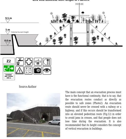
Table 4: Design elevations for zone of refuge VEB. Example for an area with historical wave height of 3 and 5 meters
Zone Historic floodtsunami Plus 30% + 3m Design ElevationVEB
Z1 3 m 0.9 m + 3 m 6.9 m
Z2 5 m 1.5 m + 3 m 9.5 m
Source:FEMA, 2008, Guidelines for Design of Structures for Vertical Evacuation from Tsunamis, FEMA Federal Emergency Management Agency and the National Oceanic & Atmospheric Administration, NOAA. Washington, D.C.
Figure 9: Elevation vertical evacuation on buildings VEB.Areasof commerce and industry.Example for an area with historical wave height of 5 meters
Source:Author
Figure 10: Elevation vertical evacuation on tower. Areas of tourism,industry, airport andports.Example for an area with historical wave height of 3 meters
Source:Author
Photo 1.Numasucity,Japan. L.Ramos
Figure 11: Elevation vertical evacuation in Elevated Squareon touristarea or parks. Example for an area with historical wave height of 5 meters.
Source:Author
Photo 2: Numasu city, Japan. L.Ramos
Figure 12: Footbridge over traintracks and highways.Example for an area with historical wave height of 5 meters
Source:Author
4. Conclusions
The evacuation routes were severely disrupted and blocked by the rubble of the earthquake, however, people looked for ways to reach as soon as possible to safe areas in the nearby hills and so avoid encountering the destructive tsunami. Safe areas that were defined for the evacuation were not prepared to contain the population, did not exist the basic services no electricity, the people despite the bad conditions of the place were kept for days, weeks and months.
Acknowledgements
The study was conducted for the SATREPS Chile tsunami project entitled “Enhancement of Technologies for Tsunami Resilient Community in Chile, which was headed by Dr. T. Tomita of Port and Airport Research Institute, jointly supported by the Japan Science and Technology Agency (JST) and Japan International Cooperation Agency (JICA) in collaboration with Chilean researchers and counterparts. The
authors acknowledge inhabitants in Talcahuano, Dichato, and Iquique who kindly answered
questionnaires, Ekhos Co. in Chile who conducted the questionnaire survey, JICA Chile office and the project coordinators who continuously supported our field work in Iquique and Biobio. The author express sincere gratitude to the students of University of Conception who participated in the survey, Ms. Alejandra Contreras, and Mr. Patricio Diaz who assisted the study by GIS mapping of evacuation routes, and Prof. Edilia Jaque who kindly provided us GIS base map data.
References
Atwater, B. F., Cisternas V, M., Bourgeois, J., Dudley, W. C., Hendley, J. W., & Stauffer, P. H. (1999). Surviving a tsunami: Lessons from Chile, Hawaii, and Japan. US Geological Survey Circular, (1187), 1-18.
Cisternas, M., Atwater, B. F., Torrejón, F., Sawai, Y., Machuca, G., Lagos, M..,...,&Husni, M. (2005). predecessors of the giant 1960 Chile earthquake.Nature, 437(7057), 404-407.
Dias, P., Dissanayake, R., &Chandratilake, R. (2006, May). Lessons learned from tsunami damage in Sri Lanka. In Proceedings of the ICE-Civil Engineering(Vol. 159, No. 2, pp. 74-81).
Fraser, S., Graham, L., Murakami,H., and Matsuo, I.(2012). Tsunami Vertical Evacuation Buildings- Lessons for international Preparedness Following the 2011 Great
East Japan tsunami, Journal of Disaster Research Vol. 7 No.sp, 2012.
FEMA P646 (2008) Federal Emergency Management Agency. Guidelines for Design of Structures for Vertical Evacuation from Tsunamis. http://www.fema.gov/media-library- data/20130726-1641-20490-9063/femap646.pdf
Goto, Y., T. Mikami, and I. Nakabayashi (2012). Fact-finding about the evacuation from the unexpectedly large tsunami of March 11, 2011 in East Japan, Proc. 15th World Conference on Earthquake Engineering, Lisbon, Portugal, Paper No. 5140.
Maruyama, Y., S. Matsuzaki, F. Yamazaki, H. Miura and M. Estrada (2010). Development of GIS dataset for damage distribution analysis after the 2010 Chile Earthquake, Journal of Japan Society of Civil Engineers, A1, Vol. 66, No.1, pp.377-385.
Murakami, H., I. Calisto, F. Miura (2012 a). Hearing survey of tsunami risk mitigation measures in Biobio
region affected by the 2010 Maule earthquake, Chile, Proc. The 9th Annual Meeting of Japan Assoc.
Murakami, H., Takimoto, K., and Pomonis, A. (2012 b): Tsunami evacuation process and human loss distribution in the 2011 Great East Japan Earthquake - A case study of Natori city, Miyagi prefecture-, Proc. 15th World Conference on Earthquake Engineering, Lisbon, Portugal, Paper No. 1587.
Murakami, H., Yanagihara, S., Goto, Y., Mikami, T., Sato, S., Wakihama, T. (2014). Study on casualty and tsunami evacuation behavior in Ishinomaki city - Questionnaire survey for the 2011 Great East Japan Earthquake -, Paper No. 1280, Proc. 10th U.S. National Conf. on Earthq. Engr.
Ramos, L., and H. Murakami (2014). Tsunami evacuation questionnaire survey for cities of Talcahuano and Dichato in the 2010 Maule earthquake in Chile Part 1 Background and survey scheme, Proc.
14th Japan Earthquake Engineering Symposium, paper ID OS13-FRI-AM-3 in print.
Soule, B. (2014). Post-crisis analysis of an ineffective tsunami alert: the 2010 earthquake in Maule, Chile, Disasters, 38 (2), pp.375-397.
López, M. L., & Vega, M. C. (2008). El nuevo riesgo de tsunami: considerando el peor escenario. Scripta Nova: revista electrónica de geografía y ciencias sociales, (12), 25.
GNS Science. Rossetto, T., Peiris, N., Pomonis, A., Wilkinson, S. M., Del Re, D., Koo, R., & Gallocher, S. (2007). The Indian Ocean tsunami of December 26, 2004: observations in Sri Lanka and Thailand. Natural hazards, 42(1), 105-124.
Satake, K., & Atwater, B. F. (2007). Long-term perspectives on giant earthquakes and tsunamis at subduction zones*. Annu. Rev. EarthPlanet. Sci., 35, 349- 374.
Shibayama, T., Esteban, M., Nistor, I., Takagi, H., Nguyen, T., Matsumaru, R.,... &Ohtani, A. (2012). Implicaciones del tsunami de Tohoku del año 2011 para la gestión de desastres naturales en Japón. Obras y proyectos, (11), 4-17. UNESCO. (2008). Preparación para casos de Tsunami: Guía para los planificadores especializados en medidas de contingencia ante catástrofes. Recuperado el 23 de mayo de 2015.
http://redsismica.uprm.edu/Spanish/tsunami/media/Presentacion_de_Tsunamis.pdfhttp://redsi smica.uprm.edu/Spanish/tsunami/media/Presentacion_de_Tsunamis.pdf