__________
* Corresponding author
E-mail addresses:m.ghanbari@student.kgut.ac.ir(M. Ghanbari);fkarimipour@ut.ac.ir(F. Karimipour);aliesmaeily@kgut.ac.ir(A. Esmaeily) DOI: 10.22059/eoge.2019.272431.1043 111
ABSTRACT
Providing a global coverage in wireless sensor networks with least possible numbers of sensor nodes has an important effect on the quality of a service and collection of information. Following a local approach, a set of nodes are first randomly distributed in the desired region, and then are moved or new nodes added iteratively until the existing holes are covered. In this study, a local approach is proposed, which improves an existing (tree-based) method for detecting coverage holes and adding new nodes. The advantage of the proposed approach is that the coverage holes are covered using the existing overlapping nodes as much as possible. It means, when a coverage hole is detected, the existing nodes with an overlapping coverage are detected and moved in order to cover the hole; new nodes are added only when required. The experimental results show the efficiency of the proposed method in terms of the number of nodes as well as the number of iterations and time complexity.
S
KEYWORDS
Wireless Sensor Network
Mobile Sensor Node
Coverage Hole
Tree-Base Method
Gravity Method
1. Introduction
Wireless sensor networks are composed of a set of inexpensive and small sensor nodes. Each sensor node has a limited capability in the measurement of phenomena, storage, processing, and communication (Akbarzadeh et al., 2013). These networks are widely used in a variety of
and habitat including environmental
applications,
monitoring, tracking moving objects, transportation, humidity control temperature and
monitoring, structural
(Argany et al., 2015). These networks have created a
dramatic transformation in traditional data collection methods and established a bridge between the physical world and the world of virtual information (Wang et al., 2006). The effective positioning of wireless sensor networks is one of the basic and effective parameters in their optimal efficiency (Akbarzadeh et al., 2013). In other words, the effective coverage of a wireless sensor network depends on
the optimum position of each sensor node within the region of interest (Afghantoloee et al., 2016). Several parameters
the coverage of
directly affect the sensor network, for example, the connections and interactions between the sensor nodes in the network, the communication between the sensors and the environmental parameters, and the communication of the environmental parameters with each other (Argany et al., 2015). Coverage holes may affect the overall performance of wireless sensor networks, such as reducing data reliability, general network topology changes, and loss of communication links (Corke et al., 2007). Thus, identifying and improving the coverage holes is one of the most important challenges in wireless sensor networks. Several optimization methods have been proposed to identify and reduce the holes as well as to increase the network coverage (Doodman et al., 2014). In general, existing methods for positioning sensors with the aim of
w e b s i t e : h t t p s : / / e o g e . u t . a c . i r
Displacement of Overlapping Sensors to Heal Coverage Holes in Wireless
Sensor Networks
Marjan Ghanbari1, Farid Karimipour2*, Ali Esmaeily1
1 Department of Surveying Engineering, Kerman Graduate University of Advanced Technology, Kerman, Iran 2 School of Surveying and Geospatial Engineering, College of Engineering, University of Tehran, Tehran, Iran
Article history:
112 increasing a network coverage are divided into two
categories of global methods and local methods. Considering the coverage problem as an optimization problem, global methods seek to determine the optimal determination of a function with the aim of determining the number and position of sensors in the entire target area (Karimipour et al., 2013). In contrast, local methods, which are mostly geometric approaches, consider an initial random distribution of the nodes in the area of interest and by moving portable sensors in the network, seek to improve the position of the nodes to increase the total coverage.
The need for random distribution of sensor nodes in some applications causes the arrangement and positioning of sensors in a network to be out of control and may result in a large gap between the nodes and the occurrence of coverage holes and loss of information in some locations. Sometimes the overlapped space of areas covered by sensors is due to a very small increase in the distance between the nodes, which makes some sensors measure similar and repeatable data and send it to the processor unit. This would increases energy consumption, extend the volume of calculations, and reduce the network lifetime without increasing the efficiency of the wireless sensor network. Therefore, in addition to detecting and reducing the existing holes in the region, the issue of reducing the overlapping sensors in the network is equally important in order to increase the efficiency and lifetime of the network and reduce the cost of setting up and network management.
This study proposes a local approach to improve the efficiency of an existing (tree-based) method for detecting and healing coverage holes. In a former research, we improved the efficiency of the tree-based method by combining it with a gravity-based method, because, for some configurations of nodes, the tree-based method is unable to determine an appropriate position for new nodes to be added. Therefore, for a certain local region, one of these methods are used based on the configuration of the existing nodes
(Ghanbari et al., 2019). The current research tries to improve
the efficiency of the combined methods by considering the idea that coverage holes may be covered using the existing overlapping nodes. For this, when a coverage hole is detected and the positions of new sensors are determined using the tree-based method, nearby existing nodes with an overlapping coverage are detected and moved in a way to cover the hole; new nodes are added only when required.
This paper is structured as follows: Section 2 provides a literature review on the problem of wireless sensor networks coverage. In section 3, the tree-based method is described to determine the position of new sensors in the network, and some configurations in which this method fails are described. Section 4 presents the details of the proposed combined methods to improve the coverage of the wireless
sensor network. In section 5, the efficiency of the proposed method in terms of the number of nodes as well as the number of iterations and time complexity is evaluated for several case studies. Finally, section 6 concludes the paper and presents future guidelines.
2. Related work
In wireless sensor networks, identification of coverage holes and network boundaries is a very important priority. Typically, the existing approaches are divided into (1) geometrical, (2) Statistical, and (3) topological categories. Geometric methods use the coordinates of sensor nodes and standard geometric structures (such as Delaunay Triangulation and Voronoi diagram) to identify the holes (Li et al., 2016). For example, Fang et al. (2006) proposed a simple and distributed algorithm to identify and construct the paths around the holes based on the location of nodes. Gosh
et al. (2004) used a Voronoi diagram for a definitive
estimation of the amount of holes contained in a network. Li
et al. (2015) used Delaunay triangulation to improve
coverage holes. Among the studies that followed statistical approaches, one can refer to the study of Fekete et al. (2004), which proposed an algorithm for identification of inner and boundary nodes based on the average low degree of nodes located on the boundary than the nodes in network. The topological properties of wireless sensor networks have also been used in several studies to identify and describe coverage holes (Li et al., 2016). For example, Kanno et al. (2009) developed a maximal simplified complex to show the existence and boundary of coverage holes. Yan et al. (2012) proposed a homology-based distribution algorithm to identify triangular coverage holes.
Having detected the coverage holes, the sensor nodes must be displaced to improve the detected holes. Generally, the existing approaches for optimizing the location of sensors are divided into two types of global and local approaches. Local approaches consider the coverage issue as an optimization problem and seek to determine the optimal determination of a function to determine the number and position of sensors over an entire target area (Karimipour et
al., 2013). For example, Ferentinos et al. (2007) used a
genetic algorithm loaded with a flexible and self-organized wireless sensor network. They showed that the design of the wireless sensor network fulfills all the specific requirements of the program using the genetic algorithm and convinces the constraints of connections and energy consumption to increase the network lifetime. Romoozi et al. (2012) used a genetic algorithm for efficiently positioning the sensors within the wireless sensor network and showed that intelligent algorithms could increase the network lifetime by finding optimal positions for sensor nodes. Akbarzadeh et al.
(2010) used an evolutionary strategy of a covariance matrix
111 the position and orientation of each sensor, and ultimately the
population of people evolved through a race generation. In contrast, local methods consider an initial random distribution of nodes in the study area and by moving portable sensors in the network, seek to improve the position of the nodes in order to increase the total coverage. For example, Cortes et al. (2004) used a gradient algorithm to control the coverage and perform an optimal measurement in a sensor network.
3. Formation of Coverage Holes
The first step in solving the coverage problem in a wireless sensor network is detecting the uncovered regions. A considerable amount of methods partition an entire study area to a set of primitive smaller regions (e.g. triangles), and then check each primitive region (triangle) to see if it is fully covered by the existing sensors. Finally, the adjacent primitive regions that are not fully covered may be joint to form a coverage hole. Li et al. (2015) proposed a more efficient Delaunay-based method to integrate the uncovered regions (triangles) and form a coverage hole. They assume that if the entire circumcircle of a triangle is covered by an existing sensor, then the entire triangle is also covered by that sensor. However, the failure of this condition does not necessarily mean that the triangle is not fully covered (Figure 1). They proposed the following procedure to detect un-fully covered triangles:
Assume a triangle that consists of three sensor nodes Si,
Sj, and Sk and whose center of circumcircle is Oc (Figure 2).
Suppose SiSj is the longest edge of this triangle. The
perpendicular bisector of SiSk intersects SiSj at Oi, and the
perpendicular bisector of SjSk intersects SiSjat Oj. SkOk is
perpendicular to SiSj at Ok. Then:
If SkOi>Rs or SkOj>Rs, then the triangle contains one
connected uncovered area.
If SkOi>Rs, SkOj>Rs and SkOk≤Rs, there are two
disconnected uncovered areas.
Otherwise, the triangle is fully covered.
Figure 1. If the entire circumcircle of a triangle is not covered by
an existing sensor, the triangle may contain uncovered areas or not
(Li et al., 2015).
After detecting the triangles with uncovered areas, they are merged to form the coverage holes. To do this, two triangles with a common edge can be merged if one of the following conditions is satisfied (Li et al., 2016):
Figure 2. Detecting a coverage hole in a triangle (Li et al., 2015).
1. The common edge is longer than twice the sensing radius.
2. The centres of circumcircles of both triangles locate in one side of the common edge.
4. Tree-Based Method
This section presents the details of the tree-based method (Li et al., 2016) in order to identify optimal locations for recovering identified coverage holes in a region. The steps below will refer to the tree-based method described in detail in (Li et al., 2016
).
(a) (b)
Figure 3. (a) The procedure of tree-based method to construct the trees and detect the roots (different trees are shown in different
colors); (b) The proposed positions for adding new sensor nodes (i.e., centers of colored root circles)
114 Now, the root centers are considered as the positions of
sensors to be added to the network (Li et al., 2016). Figure 3 illustrates this procedure.
The advantage of the tree-based method is taking the shape of the hole into account when determining the position of new sensors, because as stated, the position of new sensors are a function of the shapes of the holes. Moreover, this method adds several new sensors at the same time to cover the hole, and thus it has a good performance for large holes. However, there is no relationship between the position of new sensors, i.e., some new sensors may be placed near to each other, which causes an overlapping coverage issue. This situation mostly occurs when the ratio of the area of the hole to the area of the region covered by a sensor is small. It is especially important if the density of the sensors located on the boundary of a hole is high (Figure 4) – which results in increasing the number of roots that are close to each other.
(a) (b)
Figure 4. (a) A coverage hole; (b) Newly added nodes (black squares) using the tree-base method
In the following section, a combined approach is proposed, which uses another method for such configuration of nodes and leads to alleviating this problem. On the other hand, in the proposed approach, coverage holes are covered using the existing overlapping nodes as much as possible. It means that when a coverage hole is detected, nearby nodes with an overlapping coverage are moved in order to cover the hole; new nodes are added only when required (i.e., when nearby nodes do not overlap).
5. The Proposed Approach
This section explained the proposed approach to heal the coverage holes of a wireless sensor network.
5.1. Finding the Appropriate Positions for Adding New Sensors
As mentioned in the previous section, the tree-based method does not meet the expected performance if the ratio of the area of the hole to the area of the region covered by a sensor is small. Therefore, a combined method with a former research (Ghanbari et al., 2019) is proposed, in which this ratio is firstly computed, and the tree-based method is used only, if this ratio is bigger than a certain threshold. In other cases (i.e., smaller ratios), only one single sensor is added at the center of gravity of the hole, because there is a high chance that this single node will cover most of the hole and
the rest will be covered by moving the neighbor nodes (as will be discussed later).
It should be noted that adding a single node in the center of gravity is not appropriate for large holes, because such large holes cannot be covered by one node and thus multiple sensors will be added iteratively, while the tree-based method will add all required nodes, simultaneously. Moreover, if the center of gravity is located out of the hole, this method will not improve the coverage (Figure 5). Therefore, depending on the configuration of the nodes that create the hole, a combination of tree-based and gravity-based methods must be applied.
Figure 5. Adding a node at the center of gravity may not improve the coverage
5.2. Adding New Sensors to Cover the Coverage Holes
Having selected the position of new node(s), we search the existing nodes for possible overlapping nodes, in order to move them to cover the hole. According to Yao et al. (2009), the optimal distance (rc) between sensor nodes to prevent
coverage holes and overlapping nodes is
r
c=
r
s3
(Figure 6), where rs is the sensing radius of the nodes. Therefore, iftwo sensors are closer to each other than
r
s3
their coverage regions overlap and thus one of them can be moved without causing new holes. In the following subsections, three strategies for moving overlapping nodes are proposed.Figure 6. The optimal distance between two sensor nodes to prevent coverage holes and overlapping nodes(Yao et al., 2009).
5.2.1. Global Measurement of Distance
A simple strategy to select the appropriate overlapping sensor to be moved to the hole is to use the sensors with the most amount of overlaps. For this, after detecting the positions to add n new sensors using a tree- or gravity-based
rc
s
r
111 method, the distance between all possible pair of sensors are
computed and among which, the overlapping sensors are listed. Finally, n sensors with the most overlapping values are moved to the desired positions.
This strategy is very simple and globally eliminates the most overlapping values. Nevertheless, it has a significant computational overhead, as the distance between all pairs of nodes must be computed.
5.2.2. Cellular Network with Semi-Global Computing In order to reduce the computation overhead that raises due to computing the distance between all sensor pairs, we place a grid on the study area, whose cell size is
2
r
s3
wherers is the sensor sensing radius. Then, the cells that contain
more than one sensor are selected and one of their sensors (S) are moved to the nearest retrieval point if it satisfies both of the following conditions:
1. There is a node in the cell whose distance to the sensor S is less than
r
s3
.2. Sensor S does not locate on the boundary of the cell. Note that the first condition ensures that moving the sensor S does not cause a new coverage hole in the cell, and the second condition ensures that moving the sensor S does not cause a new coverage in one of the adjacent cells. Moreover, moving the sensor S to its nearest retrieval point reduces energy consumption due to the movement of candidate sensors.
5.2.3. Cellular Network with Local Computing
This strategy goes further in reducing the computational overhead and energy consumption through finding a candidate sensor to move as needed. For a certain coverage hole H, we first find those cells in which the boundary sensors of the hole H are located (we refer to these cells as CS). Then, the following three-step strategy is applied to heal the hole (Figure 7):
1. The sensor nodes located in the cells CS are
evaluated against the conditions presented in section 5.2.2. The sensors that satisfy these conditions are moved to the retrieval points.
2. If there are still unfilled retrieval points, the distance between the sensors in cells CS are computed with the sensors of their neighboring cells, and those sensors in the neighboring cells that satisfy the two conditions presented in section 5.2.2 are moved to these retrieval points.
3. If there are still unfilled retrieval points, the sensors that locate on the neighboring cells of CS are checked with their own neighboring cells and the conditions presented in section 5.2.2 are checked. This process continues until all retrieval points are filled with overlapping sensors.
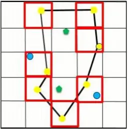
Figure 7. The black polygon is a coverage hole, and green points are the retrieval points to be filled with new sensors. Red cells are boundary cells of the hole, and blue points are candidate sensor to move.
6. Implementing and Evaluating the Results
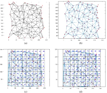
This section presents the evaluation results of the proposed approach. The sample data set contains 110 sensor nodes randomly distributed in an area of 250m×250m (Figure 8). The sensing range of nodes is 25m.
Figure 9 represents the detected coverage holes using the method presented in section 3. Following the combined method (i.e., tree- and gravity-based methods), nine retrieval points were detected for adding new sensors. Figure 10 shows the final state of the sensor network following different strategies described in previous sections.
In Figure 10(a), nine new sensors were added to the nine new suggested positions, while in Figures 10(b), 10(b) and 10(c), the existing overlapping sensors were moved to the retrieval points using the three strategies described in sections 5.2.1 to 5.2.3, respectively. Moreover, Table 1 evaluates the implementation results in terms of the number of final sensor nodes, the number of iterations, and time complexity.
The implementation results indicate that the combined method (i.e., tree- and gravity-based methods) reduces the number of final sensor nodes (more details in Ghanbari et al., 2019). On the other hand, although moving the existing overlapping sensors will increase the time complexity, it significantly reduces the number of final sensor nodes, as well as the number of iterations. Finally, comparing the three moving-based strategies shows that the local method has the least time complexity.
7. Conclusion and future guidelines
116 Figure 8. Initial position of 110 randomly distributed sensor nodes Figure 9. Detected coverage holes in the initial sensor network
(a) (b)
(c) (d)
Figure 10. Final state of the sensor network (a) Adding new sensors using the combined method presented in section 5.1; (2) Global measurement of distance; (c) Cellular network with global computing; and (d) Cellular network with local computing.
Table 1. Evaluation of the Implementation results
Method No. of final nodes No. of iterations Time complexity
Adding new sensors
Tree-based method 123 4 7.47
Combined method 119 4 7.12
Moving existing overlapping
sensors
Global method 110 2 26.48
Semi-global method 110 2 17.00
111 This method is capable of identifying fewer retrieval points
in less time than the tree- base method. Moreover, three strategies were suggested to move existing overlapping nodes in order to cover the identified coverage holes. The implementation results show the efficiency of the proposed approach. This has prevented excessive overlapping of sensors, which could lead to increasing the network utilization and a longer lifetime. However, the efficiency of the proposed approach depends on the number of sensor nodes and their sensing range, as well as the area size.
In future, one should evaluate the impact of the proposed methods on the life time of the sensors and the wireless sensor network.
References
Akbarzadeh, V., Gagné, C., Parizeau, M., Argany, M., & Mostafavi, M.A. (2013). Probabilistic sensing model for sensor placement optimization based on line-of-sight coverage. IEEE Transactions on Instrumentation and Measurement, 62(2), 293-303.
Argany, M., Mostafavi, M.A., & Gagné, C. (2015). Context-Aware Local Optimization of Sensor Network Deployment. Journal of Sensor and Actuator Networks, 4(3), 160-188.
Wang, G., Cao, G., & La Porta, T.F. (2006). Movement-assisted sensor deployment. IEEE Transactions on Mobile Computing, 5(6), 640-652.
Afghantoloee, A., Karimipour, F., & Mostafavi, M. A. (2016). A novel method for probabilistic coverage estimation of sensor networks based on 3D vector representation in complex urban environments. In International Conference on GIScience Short Paper Proceedings (Vol. 1, No. 1). 1-4.
Corke, P., Peterson, R., & Rus, D. (2007, April). Finding holes in sensor networks. In Proceedings of the workshop on omniscient space: robot control architecture geared toward adapting to dynamic environments at ICRA.1-8.
Doodman. S., Afghantoloee. A., Mostafavi. M.A., & Karimipour. F. (2014). 3D extention of the vor algorithm to determine and optimize the coverage of geosensor networks. The International Archives of Photogrammetry, Remote Sensing and Spatial Information Sciences, 40(2), p. 103.
Karimipour. F., Argany. M., & Mostafavi. M.A. (2013). Spatial Coverage Estimation and Optimization in GeoSensor Networks Deployment. Wireless Sensor Networks: From Theory to Applications, 59-83. Ghanbari, M., Karimipour, F. & Esmaeili, A. (2019). An
integrated method for covering holes in wireless sensor networks, Journal of Geomatics Science and Technology, 8(2), 225-234.
Li. W., & Wu. Y. (2016). Tree-based coverage hole detection and healing method in wireless sensor networks. Computer Networks, 103, 33-43.
Fang, Q., Gao, J., & Guibas, L. J. (2006). Locating and bypassing holes in sensor networks, Mobile networks and Applications, 11(2), 187-200.
Ghosh, A. (2004, November). Estimating coverage holes and enhancing coverage in mixed sensor networks. In 29th
annual IEEE international conference on local computer networks (pp. 68-76). IEEE.
Li. W., & Zhang. W. (2015). Coverage hole and boundary nodes detection in wireless sensor networks. Journal of network and computer applications, 48, 35-43. Fekete, S. P., Kröller, A., Pfisterer, D., Fischer, S., &
Buschmann, C. (2004, July). Neighborhood-based topology recognition in sensor networks. In International Symposium on Algorithms and Experiments for Sensor Systems, Wireless Networks and Distributed Robotics (pp. 123-136). Springer, Berlin, Heidelberg.
Kanno, J., Buchart, J. G., Selmic, R. R., & Phoha, V. (2009, June). Detecting coverage holes in wireless sensor networks. In 2009 17th Mediterranean Conference on Control and Automation (pp. 452-457). IEEE.
Yan, F., Martins, P., & Decreusefond, L. (2012, June). Accuracy of homology based approaches for coverage hole detection in wireless sensor networks. In 2012 IEEE International Conference on Communications (ICC) (pp. 497-502). IEEE.
Ferentinos, K. P., & Tsiligiridis ,T. A. (2007). Adaptive design optimization of wireless sensor networks using genetic algorithms, Computer Networks, 51(4), 1031-1051.
Romoozi, M., & Ebrahimpour-Komleh, H. (2012). A positioning method in wireless sensor networks using genetic algorithms, Physics Procedia, 33, 1042-1049. Akbarzadeh, V., Ko, A. H. R., Gagné, C., & Parizeau, M.
(2010, September). Topography-aware sensor deployment optimization with CMA-ES. In International Conference on Parallel Problem Solving from Nature (pp. 141-150). Springer, Berlin, Heidelberg.
Cortes, J., Martinez, S., Karatas, T., & Bullo, F. (2004). Coverage control for mobile sensing networks, IEEE Transactions on robotics and Automation, 20(2), 243-255.