-
International Journal of Environment, 2(2): 106–116 (2012) ORIGINAL ARTICLE
Flood Risks for the Char Community on the Ganges-Padma
Floodplain in Bangladesh
Mohammad Najmul Islam
ISSN: 2186- 6872 (print) ISSN: 2186-0009 (online)
http://www.BENJapan.org/IJE
ARTICLE HISTORY Received: 05 December 2011 Revised: 10 May 2012 Accepted: 05 December 2012 Published online: 24 December 2012
Abstract
Due to population pressure and scarcity of land in Bangladesh many poorest communities are obliged to live in the floodplain riverine areas known as char-lands. The excess of water happens during the monsoon because of widespread flood which damages char-land settlements, agricultural crops, dwelling assets, infrastructures and communication networks. The present study clarifies some aspects of char livelihood, especially the overall risk to flood hazards and the variation of the vulnerability depending on the location of char-lands in Bangladesh. It was found that island char and attached char villages were most severely affected by annual floods. During catastrophic flood hazards the poor tried to survive by selling off their movable assets. The riverine char-land should be incorporated into the flood and erosion forecasted zones. In order to reduce damages the flood danger level and warning system need to be developed for the floodplain areas.
Keywords:Padma, flood hazards, char-land, Bangladesh
2012, International Journal of Environment. All rights reserved.
I.
I
NTRODUCTION1Bangladesh is one of the largest floodplain and delta areas in the world. The low topography and high annual rainfall with high concentration in the five monsoon months result in the annual inundation of about one-third of land in Bangladesh. In a normal year, one-tenth of the total land surface is severely hit by floods [1]. Land is very limited in Bangladesh, and the pressure of population on it is constantly on the increase. The Char-dwellers2 and their livelihood in the Ganges-Padma floodplain are under threat due to recurrent floods. Devastating events have occurred in the recent past in 1987, 1988, 1998, 2004 and 2007. The floods in 1998 were the longest-lasting and most devastating in 100 years. In total, 53 of the 64 districts of Bangladesh were
AUTHORS’ INFO
Mohammad Najmul Islam
e-mail: najmul@asafas.kyoto-u.ac.jp ASAFAS, 46 Shimoadachi-cho, Yoshida, Sakyo-ku, Kyoto University, Kyoto, 606-8501, Japan
2 The people who are living in char-lands and whose livelihood fully depends on char-lands and its resources are known as char-dwellers.
affected by floods with differing magnitude, and about 50 percent of the country was under water for periods of up to 67 days, at depths of up to 3 meters. The most severe flood occurred along the main river courses and was particularly serious in a wide stretch in the overall area of confluence of the three major rivers [2].
According to the IPCC Special Report on the Regional Impacts of Climate Change [3], there would be drastic changes in rainfall patterns in the warmer climate and Bangladesh may experience 5 to 6 percent increase of rainfall by 2030, which may create frequent big and prolonged floods. Riverine islands and attached bars are known as char-land. Compare to other part of Bangladesh these char-land areas are highly vulnerable to flood hazards. The excess of water occurs during the monsoon because of the widespread flood which damages char settlements, agricultural crops, dwelling assets, infrastructures and communication networks. Seasonal flood hazards reduced livelihood opportunities, household income and employment of char people. The Hyogo Framework for Action 2005- 2015 also gave emphasis on to assess local disaster risks and to build a culture of safety and resilience, and strengthen disaster preparedness
for effective response at all levels [4]. However, the flood hazard remains hazard without becoming disaster if vulnerability is reduced through some preparations and actions. How to reduce such damages, losses and insecurity is a big challenge for these vulnerable communities.
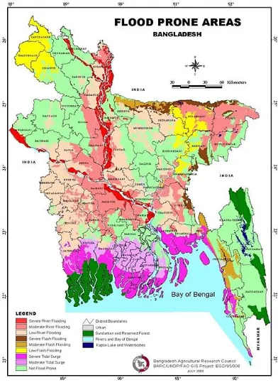
Fig. 1 illustrates different types of flood prone areas in Bangladesh. This map also shows that the severe river flooding areas are the most affected to flood hazards which are located on and along the major three rivers. So, the people of riverine floodplain and char-lands are the most vulnerable groups to flood and erosion disaster in Bangladesh.
Fig. 1. Map of Flood Prone Areas in Bangladesh (Source: Bangladesh Agricultural Research Council
(BARC)/GIS Project, BGD/95/006)
Fluvial dynamics and hydro-morphological characteristics of char-lands are quite different from bank line and other floodplain areas in Bangladesh. The severity of damage, risk and vulnerability from flood and riverbank erosion hazards are much higher in riverine char-land residents compared to other parts of Bangladesh.
Poverty and vulnerability are highly
geographically concentrated in the chars than the plain land areas. Nevertheless, no conscious effort was taken in the past aimed at true
development of life and livelihood of the char people, who have always remained excluded from the main stream [5].
Poverty and vulnerability are highly
geographically concentrated in the chars than the plain land areas. Nevertheless, no conscious effort was taken in the past aimed at true development of life and livelihood of the char people, who have always remained excluded from the main stream [6]. Different studies [6]-[13] have been carried out on flood disasters and its impacts on floodplain rural livelihood in Bangladesh. Baqee illustrated the uncertainties of the lives of the inhabitants of char-lands in Bangladesh. The study described the survival strategies of the char people in the face of both natural and man-made crisis [14]. Schmuck tried to explain the coping strategies of the Jamuna char-people and made comparison between local and engineering knowledge, experiences for action against natural forces [15].
In spite of the above mentioned researches, there is a gap to do in-depth research to assess flood risks and vulnerabilities on the riverine char communities in Bangladesh. So a complete study is required for the understanding of overall flood situation of the study area and its risks on char livelihood. The present study assesses the flood risks on different sectors of char livelihood as well as the characteristics of vulnerability from flood hazards. The present study will be helpful for conducting future development program and policy formulation related to flood and riverbank erosion disaster for the char-dwellers in Bangladesh.
II.
M
ETHODOLOGY ANDD
ATAC
OLLECTION Several times’ field visits and surveys were conducted at various time periods during the monsoon (July to September) and the dry season (February to April) in 2009 and 2010. With the help of interview schedule 100 percent household heads (242) interview were conducted to collect quantitative data from three study villages. In addition different tools of Participatory RapidAppraisal (PRA), including Focus Group
information’s by the char-dwellers. Hydrological data were collected from Bangladesh Water Development Board (BWDB); Flood related data were collected from Flood Forecasting and Warning Centre (FFWC), and meteorological
data were collected from Bangladesh
Meteorological Department (BMD). All the available data and information collected were compiled and analyzed through MS Excel and PASW (Predictive Analytics Software). Based on the analyses of data and information conclusions were made.
III.
P
ROFILE OF THES
TUDYA
REA The Padma River is well known for heavy bank erosion, shifting channels and sandbars that continually emerge in its course. The Padma has a total catchment of 1.7 million km2 – the combined catchment of the Brahmaputra and Ganges. The Padma is a wandering river characterized by unstable bank lines and rapid rates of lateral movement [8]. The study is primarily concerned with riverine char-lands of active Padma floodplain area which is subject to erosion and accretion. The inhabitants of the char-lands are among the most hazard-prone people of Bangladesh, exposed as they are to floods and erosion. Structural flood protection measures are unlikely to benefit these people, and embankments may even raise flood levels within the char-lands, increasing the risks to which they are exposed. Reliable information about these areas and the people who live in them has always been scarce. According to the Irrigation Support Project for Asia and Near East (ISPAN) studies [8], riverine floodplain lands in Bangladesh were classified into the following three types: i) Island Char, ii) Attached Char and, iii) Unprotected mainland.For this classification, Island chars are defined as land that, even in dry season, can only be reached by crossing a main river channel. Attached char-land is accessible from the main land without crossing a main channel during the dry season or sometimes crossing lesser channels may be required, yet is inundated or surrounded by water during the peak of a normal monsoon.
Zanjira Upazila of the District of Shariatpur was selected for the study which is located on the right bank of the river Padma, 78 km away from Dhaka. It belongs to the AEZ (agro-ecological
zone)-10, Active Ganges Floodplain of the mighty river Padma, the confluence flow of the Ganges and the Brahmaputra (Jamuna) river. The study villages were located in the char-land of Maowa-Sureshwar downstream reach which typically experienced severe flood and riverbank erosion. Taking into consideration the flood and erosion experience and risks, the author finally selected one village from each type of char-land from the study site; Saral Khar Kandi-SKK
(island char village), Eakub Matbarer
Kandi-EMK (attached char village) and Kalu Beparir Kandi-KBK (unprotected bank line village) (Fig. 2).
Fig. 2. Types of char-lands with village locations (Source: Prepared by the author based on field information.)
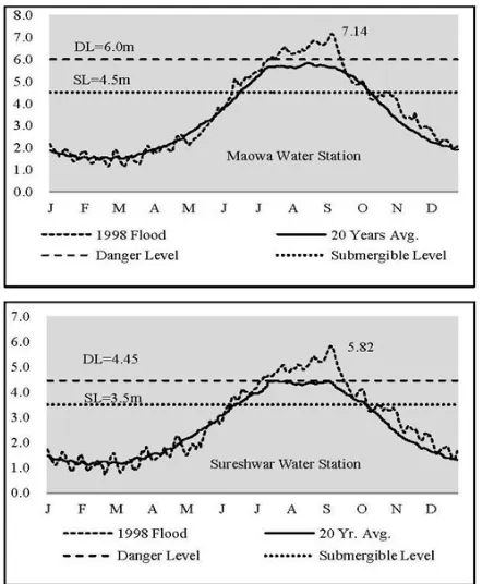
The study villages are located between the two water stations of BWDB on the river Padma; the Maowa Water Station (MWS) is located 20 km upstream from the study site and the Sureshwar Water Station (SWS) is located 5 km downstream. Fig. 3 and Fig. 4 shows the water level of 20 year average and in the year of 1988 and 1998. According to my field survey and observation all the agricultural and fallow land in the study villages were submerged when the water level was at 3.5 meter at SWS and 4.5 meter at MWS. And when the water level crossed the danger level (4.5 meter and 6 meter at SWS and MWS, respectively), all the homestead area,
trees and houses are submerged. The
char-dwellers are accustomed to face the situations near the danger level, but if the water crosses the danger level they have to survive in a hazardous and tough environment for 40-90 days. Different characteristics of three study villages have been presented in Table 1.
-
Fig. 3. Flood hydrographs of1988 flood in two water stations (Source: Prepared by the author based on field observation and
hydrological data from BWDB.)
Fig. 4. Flood hydrographs of 1998 flood in two water stations. (Source: Prepared by the author based on field observation and
hydrological data from BWDB)
A. SKK village (Island char)
The SKK village was located in the mid-channel island bar in the middle of the Padma. The people of Island char have to cross around 8-10 kilometre distance of main river channel through local engine boats to communicate with the main land. The present location of the SKK village settlement was established on a natural levee of the island char. The frequency of river erosion and dwelling displacement experiences in the SKK village was 8.45 times and 17.14 times during last 40 years. As a result they have no more own agricultural and homestead land. In the case of the SKK village the major reasons they leased-in homestead land rather than purchased were 1) there was a high possibility that their previously owned land would emerge again, 2) there was a high risk of future erosion, and 3) they were too poor to purchase it. Such a situation was
observed widely among the island
char-dwellers.
The average homestead area was 6.4 decimals per household which were leased from the land owners. The homestead land, on average, was 1.0 meter higher than floodplain farmland but varied from 0.5 to 1.5 meter according to the financial ability of each household. In 2009 there were 85 households and 470 people, with an average size of 5.5 persons per household. The average number of labour force was 2.5 persons per household. The average year of schooling of household head was 1.6. The major source of income was agricultural labour and livestock rearing. Compare to the SKK village had the largest number of livestock.
B. EMK village (Attached char)
The EMK village was located in an attached bar (adjacent char) on the right bank of the river Padma. In the monsoon (June to October), the village was submerged by the river water. The people of attached char have to cross around 1-2 kilometer distance of a branch of main river channel through country boats in monsoon (June to November) and on foot in dry season (December to April) to communicate with the main land. The present location of
-
Table 1. Characteristics of three study villages (Source: Prepared by the author based on field survey in 2009 and 2010).
Variables SKK Village EMK Village KBK Village
Location of the Village - On the mid-river channel - 8 km away from bank line
- Beside the right bank of the main channel - 1 km away from bank line
- On the right bank of the Padma river
Flood Inundation Period July to October June to November August to October
Depth of flood inundation 1.0 meter 3.0 meters 0.5 meter
Flood duration 4 months 6 months 3 months
Average Homestead Plinth
Height from Farmland 0.5 to 1.5 meter 3.0 to 3.5 meter 0.5 to 1.0 meter
Ownership of homestead
area Rent in 100% Own land 100%
Rent in 91%, Own 9%
Frequency of Erosion
Experiences (1968-2008) 8.5 times/HH 4.2 times/HH 6.2 times/HH
Frequency of House
Displacement (1968-2008) 17.1 times/HH 8.2 times/HH 9.9 times/HH
Nature of wave erosion Very high High Moderate
Water velocity during
flood Very high High Moderate
Nature of wind speed
during cyclone Very high High Moderate
Most damageable things after flood
All kinds of house structures
Homestead area, trees and houses structures
Trees and thatch house structures Status of Flood Shelter No flood shelter No flood shelter Under construction Distance of nearest Health
Complex and growth center 13 km 6 km 5 km
Mode of communication with distance
8 km river + 5 km road
1 km river
+ 5 km road 5 km road
Mode of transportation during flood
Engine boat & rickshaw/van
Country boat &
rickshaw/van Rickshaw/van
the EMK village settlement was established on a natural levee of the attached char. In the floodplain land of the homestead area usually stands on elevated mounds. The average homestead area was 7.5 decimals per household which were their own land.
The average height of homestead area was 3.0 to 3.5 meter from agricultural floodplain land in the EMK village. But the height was being increased to protect their homestead from flood; every 1 or 2 years interval, the residents had to raise their dwelling height even though it was expensive and difficult. The frequency of river erosion and dwelling displacement experiences in the EMK village was 4.24 times and 8.16 times
during last 40 years. They got back their own accreted land and re-established their village settlement in 1986. As a result they have own homestead area and farming land though 57.3 decimal/household land remain under river. In 2009, there were 72 households and 402 residents, with an average of 5.6 persons per household. The average number of labour force was 2.5 persons per household and the average year of schooling of household head was 1.3. The major source of income of this village households were farming.
C. KBK village (Unprotected Bank Line)
The KBK village was located in the unprotected floodplain land on the right bank of the river
Padma. During the peak period of monsoon (August to October), the village farmland was submerged by the river water. The KBK village was a newly migrated village, located on agricultural farmland without any elevation. The frequency of riverbank erosion and dwelling displacement experiences in the KBK village was 6.15 times and 9.91 times during last 40 years. In 2007 the KBK village faced massive erosion which forced to migrate 3 km away. As a result they have not own agricultural and homestead land. Only 8.2 percent households purchased land for homestead and rest of 91.8 percent household’s leased-in land rather than purchased due to poverty. The elevation of homestead land, on average, was 1.0 meter higher than floodplain farmland but varied from 0.5 to 1.0 meter according to the financial ability of each household. In 2009, there were 85 households and 450 people, with an average of 5.3 persons per household. The average number of labour force was 2.3 persons per household and average year of schooling of household head was 2.8. The major sources of income in household level were agricultural and non-agricultural labour and foreign remittance.
IV.
F
LOODR
ISKS ONC
HARL
IVELIHOOD The consequences of floods have both socio- economic and spatial dimensions. It causes considerable damage to standing crops, livestock,houses, transportation and communication
systems, educational and other social facilities. It also affects seriously the everyday’s livelihood of the char-dwellers.
A. Homestead and house structures
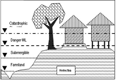
Like in other flood prone area in Bangladesh, the homesteads stand on raised mounds in the study villages. All the homesteads were fully submerged and unusable during floods. Waves battered the foundation of their homesteads and they lived in constant fear of their homestead being washed away.
According to the field survey 33 percent and 39 percent of households lived in bamboo fence house and thatch house respectively in SKK village. Due to their poverty and highest frequency of erosion, their dwellings were not strongly built. On the other hand, 64 percent of households in EMK village had tin sheet house which were better and stronger than thatch and bamboo fence house. Fig. 5 is showing a vertical cross section of char-dwelling with different
magnitude of water level which causes damage of physical structures.
Alternate dry and wet conditions due to the frequent fluctuation of water level caused cracks in mud structures and deterioration in wooden, bamboo materials and tin sheets. Wooden and bamboo structures are easy to be rotten and tin sheets are easy to be rusty. These were in constant need to repair but they could not afford it.
B. Agricultural sector
The study area is located in the Padma river basin which remain flooded by 1.5 to 2.5 meter depth from June to October [16]. Fig.6 shows that during July to October there is no working opportunity in agriculture, so that agricultural wage labourers migrate to the urban and industrial areas. On the other hand, November to June is the busy season for agriculture.
The main Kharif-13crops grown in the study area are Jute, Broadcast Aus, Deep water Aman and the major Rabi4 crops are Boro (HYV),
mustard, chili, coriander and pulses. The char-dwellers plant the seedlings of Kharif-1 crops in the dry season with a hope that the crops would be harvested before the monsoon but it frequently happens that most of the crops go under water by early floods, high floods, rapid rise and flow of water, and/or late floods. Among the study villages, EMK village is the most vulnerable to such flood calamities (Table 2). Once in several years on average, flood causes disastrous bank erosion and people are obliged to migrate to other area [10].
Fig. 5. Vertical cross section of a char dwelling in different water levels (Source: Prepared by the author based on field observation in 2009 and 2010)
3 Kharif—Pre-monsoon and monsoon growing season 4 Rabi—dry growing (sunny) season, (including both the
cool winter and hot-pre monsoon season)
-
Workload & Crop calendar
M A M J J A S O N D J F
Kharif-1 6
5
Kharif-2 4
3
Rabi 2
1 Fig. 6. Seasonal work load and crop calendar
(Source: Field survey by the author in 2009-2010. Note: Grey shed indicates the work load in agricultural season)
Table 2. Status of farming households Village name Farm Based HHs Annual Income (BDT) Farm Based Income Land (decimal) Rice purchased from market (months) Own Opt.
SKK 20% 8750
0
40600 00 177 5.8
EMK 85% 9030
0
45900 123 189 6.2
KBK 11% 8110
0
34300 13 100 7.6
Source: Field survey by the author in 2009-2010.
Table 3. Determinants of household income (co-efficient and t-value) Variables Pooled Island char
village (SKK) Attached char village (EMK) Bank line village (KBK)
Constant 6418
(0.567) 23254*** (4.714) 6660 (0.576) 13542 (-0.555) No. of labour force 19747*** ( 4.883) 10405*** (5.701) 21568*** (4.812) 26786** (2.494) Year of schooling 9461*** (4.839) 2382** (2.094) 6238*** (3.318) 14525*** (3.041) Agricultural owned land 30.06 ( 0.579)
- 78.74**
( 2.410) 35.70 (.048) Agricultural rented land -3.87 (-0.091) 53.85** (2.173) 10.20 (0.358) -410 (-1.257 )
No. of cows 2190
( 0.739) 3766*** (3.28 ) -3680 (-1.186) 2974 (0.277 )
No. poultry -178
( -0.240) 894** (2.410) 728 (1.245) -2750 (-0.968)
DSKK 10587
(-1.142)
- - -
DEMK 2953
(0.265)
- - -
*** 1% Level of significance; ** 5% level of significance Source: Field survey by the author in 2009-2010.
C. Sources of income
Flood affects not only to the livelihood of char people but also to their income. People in the study area suffer from low and unstable income and the income level fell sharply during the flood. The study revealed that 79 percent households drastically changed their source of income from farm-based wage labour and farming into non-farm wage labour, rickshaw-van puller, fishing and boating.
Another 18 percent households become jobless during monsoon flood seasons (Fig. 7). Especially during the flood peaks household income of many farm-based and wage labour households were drastically decreased and they suffered much.
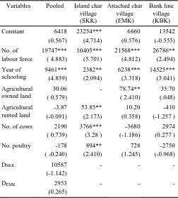
There were statistically
significant relations (Table 3) between household annual income and some variables. In SKK village, number of labour force, year of schooling, agricultural land and livestock had positive relation with income. The variables with positive relations with income included number of labour force, year of schooling and agricultural land in EMK village and number of labour force, year of schooling in KBK village. Therefore, human resource
development is one of the
important factors to raise income for the char-dwellers.
D. Livestock
Livestock are important in nutrition and source of income for the char-dwellers. Livestock rearing can be an important alternative job, given their very little land to cultivate and limited access to capital for doing small business. The dwellings of island char area are simple but spacious, which provides the people with the opportunity to raise livestock (Table 4). Flood damages cow- sheds, causes scarcity of livestock
-
Fig.7. Seasonal variations of household income source (Source: Field survey by the author in 2009-2010)
feed and lack of medicine and treatment becomes the major threat for livestock rearing in SKK and EMK villages. To meet the crisis during flood often they are obliged to sell their livestock’s in low price.
E. Fuel and cooking place
The char-dwellers usually use jute-stalk, dry cow-dung, branches and crop residues as fuel. But during flood char-dwellers face difficulty in obtaining fuel for cooking. Due to flood inundation of homestead area, they couldn’t make dry their collected and processed fuels like branches and jute steaks with cow-dung. In addition, the kitchen is usually situated on the floor of homestead, which is often submerged and unusable during flood.
F. Transportation and communication
Usually the char-dwellers moves within the char-land through walk and cross the big river by engine boat. But communication facilities to mainland often become malfunctioned in the monsoon flood for the island and attached char-dwellers. There is no way to communicate even within the areas, or between the neighbouring houses without using boat or float. Sometimes due strong wind, high wave and
strong river current disrupted regular
communication with the main land. The number of trip reduces sharply and people have to change transportation means frequently. People
face difficulties to go to workplaces and bazaars as local roads become unusable. Children's education suffers because of their location in isolated places, especially in the island and attached char.
Table 4. Status of livestock rearing (household average)
Vill
ag
e
n
am
e
No
.
of
HHs
In
co
m
e
fro
m
Li
v
esto
ck
in
BDT
No
.
of
c
o
w
No
.
of
g
o
at
No
.
of
p
o
u
lt
ry
Ho
m
este
ad
a
re
a
In
d
ec
ima
l
SKK 91% 18100 1.4 0.7 6.4 6.3 EMK 78% 12600 1.1 0.9 7.7 7.8 KBK 66% 13600 1.0 0.5 5.1 9.0 Source: Household survey by the author in 2009-2010.
G. Water and sanitation status
In normal situation, all char-dwellers use hand tube-well as source of water for drinking purpose. During flood, hand tube-well and other safe water sources became submerged; as a result, safe water became scarce. Human and animal excreta, rubbish and contaminated soil mix with floodwater polluted both surface and ground water. People could not boil water for decontamination due to shortage of dry cooking place as well as of fuel. During flood 85 percent
23%
13%
8% 17%
18% 5%
9% 7%
Wage labour (Non-farm) Rickshaw & Van-Puller
Boating Seasonal Fishing
Job less Small Trading
Service Foreign Remittance
During Flood
43%
12% 24%
5%
9% 7%
Wage Labour (Farm) Small Farming Medium Farming Small Trading
Service Foreign Remittance
Before Flood
and 97 percent of households used flood water for household use and cooking purpose in SKK and EMK village respectively.
Water supply and sanitation facilities are always vulnerable to flooding. In char-land areas, usually the toilet is located in a corner to lower place then the ground level of homestead. Hence, during flood toilets are affected and submerged earlier. As water level rises during flood, toilet becomes more exposed.
H. Health care services
During flood disasters emergency treatment facility and medicine are highly needed for the char- dwellers. As the island and attached char villagers have no scope to get primary treatment, saline, water purification tablets and emergency medicine during floods they are most vulnerable to water borne diseases. Especially the children, lactating mother, pregnant women and the old peoples are vulnerable during flood hazards.
I. Water and sanitation status
In normal situation, all char- dwellers use hand tube-well as source of water for drinking purpose. During flood, hand tube- well and other safe water sources became submerged; as a result, safe water became scarce. Human and animal excreta, rubbish and contaminated soil mix with floodwater polluted both surface and ground water. People could not boil water for decontamination due to shortage of dry cooking place as well as of fuel. During flood 85 percent and 97 percent of households used flood water for household use and cooking purpose in SKK and EMK village, respectively.
Water supply and sanitation facilities are always vulnerable to flooding. In char-land areas, usually the toilet is located in a corner to lower place then the ground level of homestead. Hence, during flood toilets are affected and submerged earlier. As water level rises during flood, toilet becomes more exposed.
J. Health care services
During flood disasters emergency treatment facility and medicine are highly needed for the char-dwellers. As the island and attached char villagers have no scope to get primary treatment, saline, water purification tablets and emergency medicine during floods they are most vulnerable to water borne diseases. Especially the children, lactating mother, pregnant women and the old peoples are vulnerable during flood hazards.
V.
F
LOODS
ITUATION,
F
ORECAST ANDE
ARLYW
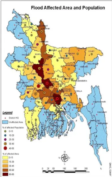
ARNINGAccording to the Disaster Management Information Centre (DMIC), three severest flood- affected districts in Bangladesh are Sirajganj, Manikganj and Shariatpur where 60 to 80 percent s of each area are affected regularly by flood. Due to the geographic location Shariatpur District is particularly the multi-hazards prone area where 40 to 55 percent district people are affected (Fig. 8). About 56 percent of the district belongs to medium to deep flooded area, being prone to flood almost every year. Submergence duration prolongs if the river water level remains above danger level for longer period of time [17].
Fig. 8. Map of flood affected area and population (Source: Disaster Management Information Center, CDMP)
from my field observation that before broadcasting the flood warning information the agricultural land and the settlement area of the study villages were submerged under water. After the water level crossed the ‘River Danger Level’, the FFWC had made announcement to the media. Moreover, although the danger level needs to be updated regularly, it is not done by FFWC.
The SWS area submerged earlier than the MWS area though the SWS is situated in downstream where maximum char’s are located is a great concern of the study. In this regards the FFWC should incorporate the SWS as a flood forecasting monitoring stations. The river danger level and warning signals should be modified for the low-educated char peoples. The present concise format of “Flood Bulletin” through public radio and television do not provide detailed information for the flood victims.
The existing flood warning and information system by FFWC is not enough for the char- dwellers. The study revealed that the char- dwellers need early flood information regarding inundation area, depth of water, inundation period, water velocity and duration of flood so that they can make preparations to mitigate the impact of the flood on their lives and livelihoods. Though few households have radio, they do not depend on the news of media because the information provided sometimes become irrelevant to their local contexts and is too technical to understand. The floodplain communities need warning information in advance for their local context so that they can harvest their crops and protects household structures, cultured fish and other assets from flood damages.
VI.
C
ONCLUSIONS ANDR
ECOMMENDATIONSThe findings show that the Padma riverine floodplain population is highly vulnerable to flood hazards in the absence of technological adjustment and policy support. Farm-based wage labourers and farmers were seriously affected from seasonal flood hazards. As a part of the emergency action, relief in the form of seeds, fertilizers, agricultural tools and livestock are essential for the farming and non-farming char-dwellers after recession of floods.
Almost every year, the char-dwellers had to survive in a tough and risky situation during the peak flood season from July to September for 2-3 months. In this season, adult males usually stay in
mainland for work and only females, children and elderly remain in char, where they face various high risks. And in a severe flood year, a catastrophe occurred and their houses or even the village as a whole disappeared with a river erosion and they had to migrate to other areas. During floods, a large percentage of char people have only the polluted water of the river to drink and cook food since most of the hand tube-wells get submerged. Fuel is in short supply during flood; the option of boiling the water prior to drinking is not so practical. Problems of storing and cooking food, drinking water leads to malnutrition and diseases.
The existing river water danger level and forecasting system by FFWC is not properly functioning in floodplain riverine char lands, although around 10 million people are living on the riverine floodplain areas in Bangladesh [15]. The present concise format of Flood Bulletin through public radio and television do not provide detailed information for the multi-level flood victims. Local government and community also do not know how to use the flood forecasts and warning information.
Educational programme also needs to be developed to encourage people to take action against flood disaster. All preparedness and survival initiatives must take into account the requirement of farmers, fishermen and other professional groups including their livestock.
As 79 percent households drastically changed their sources of income and another 18 percent households become jobless during monsoon flood, experience and local resources oriented income generating activities should be developed at community level. The river floodplain and char-land area should be included into the flood zone and the river danger level and warning signals for the low-educated char peoples should be developed.
A
CKNOWLEDGEMENTSThe author would like to thanks Dr. Koichi Fujita, Professor of CSEAS, Kyoto University for his invaluable comments and suggestions on earlier drafts of this manuscript. The author would also like to show his appreciation to the Japanese Society for Promotion of Science (JSPS) for financially supporting the research, and the people of Zanjira Upazila for their kind assistance.
R
EFERENCES[1] Zaman MQ. 1998. Jore-Jar-Jomi-Tar: A Case for Reform in Char Land Policies and Administration in Bangladesh, Riverbank Erosion Impact Study, Jahangirnagar University, Savar, Bangladesh. [2] Hofer TB. 2006. Messerli, Floods in Bangladesh:
History, dynamics and rethinking the role of the Himalayas, Tokyo: United Nations University Press.
[3] Intergovernmental Panel on Climate Change (IPCC). 2007. The Regional Impacts of Climate Change: An Assessment of Vulnerability, IPCC Special Report.
[4] UNISDR. 2005. Hyogo Framework for Action 2005-2015, “Building Resilience of Nations and Communities to Disasters” World Conference on Disaster Reduction, 18-22 January 2005, Kobe, Hyogo, Japan.
[5] Barkat A, Proshanta KR and Khan MS. 2007. Charland in Bangladesh: Political Economy of Ignored Resource, Dhaka: Pathak Shamabesh. [6] Zaman MQ. 1988. Jore-Jar-Jomi-Tar: A Case for
Reform in Char Land Policies and Administration in Bangladesh. Riverbank Erosion Impact Study (REIS), Jahangirnagar University, Savar, Bangladesh.
[7] Elahi KM. 1991. Impacts of Riverbank Erosion and Flood in Bangladesh: an Introduction: Riverbank Erosion, Flood and Population Displacement in Bangladesh. River Erosion Impact Study (REIS), Jahangirnagar University, pp.10.
[8] Irrigation Support Project for Asia and the Near East (ISPAN). 1993. Charland Study Overview: Summary Report. The Flood Plan Coordination Organization, Dhaka.
[9] Thompson P and Tod I. 1998. Mitigation flood losses in the active floodplains of Bangladesh. Disaster Prevention and Management, 7(2): 113-123.
[10]Brammer H. 1997. Agricultural Disaster Management in Bangladesh, Dhaka: The University Press Limited.
[11]Brammer H. 2004. Can Bangladesh be Protected from Floods? The University Press Limited, Dhaka.
[12]Yoshitani J Takemoto N Merabtene T. 2007. Factor Analysis of Water-related Disaster in Bangladesh. The International Center for Water Hazard and Risk Management, Ibaraki-Ken, Japan, pp. 9.
[13]Paul SK and Routray JK. 2010. Flood proneness
and coping strategies: the experiences of two villages in Bangladesh. Disaster, 34 (2): 489-508. [14]Baqee A. 1998. Peopling in the Land of Allah
Jane, Power, Peopling and Environment: The Case of Char Lands of Bangladesh, Dhaka: The University Press Limited.
[15]Schmuck WH. 2001. Facing the Jamuna River: Indigenous and engineering knowledge in Bangladesh, Bangladesh Resource Center for Indigenous Knowledge (BARCIK), Dhaka. [16]Local Government Engineering Department
(LGED). 2007. Shariatpur District Water Resources Assessment, Second Small Scale Water Resources Development Sector Project, Dhaka. [17]Flood Forecasting and Warning Center (FFWC),
Accessed on 31 January, 2011, Available: http://www.ffwc.gov.bd
116