GSJ© 2018
www.globalscientificjournal.com
GSJ: Volume 6, Issue 1, January 2018, Online: ISSN 2320-9186
www.globalscientificjournal.com
ASSESSMENT
OF
RAIN
WATER
HARVEST
POTENTIAL
IN
SOKOTO
BASIN,
NIGERIA
FOR
IMPROVED
WATER
RESOURCE
MANAGEMENT
Dr Murtala A. Gada
mahagada@gmail.com +2348036027104
Geography Department, Usmanu Danfodiyo University, Sokoto
Abstract
The Sokoto basin is part of north-western Nigeria; an area characterised by semi-arid condition largely due to high rainfall variability leading to frequent drought occurrence and water scarcity in the region. Rainwater harvesting can serve as an effective coping strategy in addressing the water deficit experienced by the people during the long dry season. This paper aimed to assess the rainwater harvest potential of Sokoto basin using variable landscape approach to improve water resource management. Simulations were run for 6 sequential rainfall years (2000-2005) to determine the distribution of rainfall input into output of runoff, actual evapotranspiration and groundwater outflow. The runoff and some groundwater outflow are considered as potential components for harvest and storage to be used after rainy season. The high potential areas for harvest were identified and classified using GIS and remote sensing techniques. The paper recommends a unified rational approach to water resources planning and development and suggests that small household water reservoirs and community earth dams should be built to capture excess runoff from rooftops and high runoff contributing landscapes for use during the dry season.
Keywords
GSJ© 2018
www.globalscientificjournal.com
Introduction
Sokoto Basin is in Sub-Saharan Africa within the semi-arid part of the continent characterized by limited water resources and increased pressure of accessibility due to expanding urban, industrial and agricultural water requirements. WHO/UNICEF (2012) reported that globally, over 40% of all people who lack access to drinking water live in Sub-Saharan Africa. The problem persists more in the region because of slow and poor technological advancement, low incomes and institutional capacity to mitigate the problem (WHO, 2011, MacDonald, 2005, Kevin and Nicholas, 2010). Even though the potential impacts of climate change have long been recognised, there has been comparatively little research relating to its impact on water resources (IPCC, 2001). Today however, greenhouse warming associated with climate change continues to dominate the world’s science and policy agenda on global change, and the fundamental concern is the impact of these changes on hydrology and water resources. The major concern is how the human society directly influences the state of the terrestrial water cycle in the visible presence of rapid population growth and economic development thus, altering the equilibrium to water quality, quantity and availability in many areas around the world (WaterAid, 2007).
Water is one of the critical factors that determine settlement and development of people in Sokoto basin. Even though the region is well endowed with water resources, and is well drained with a close network of rivers and streams (Ayoade and Bamwo, 2007), most of the smaller rivers are however, seasonal, especially in the upper catchment of the basin. The expanding population and the threat posed by climate change are putting the water resources under pressure and calling for new approaches for water resource planning and management. As water demand is increasing due to modern developments, changing life styles and population growth, the challenges of meeting the increasing demand became necessary for improving development and economic growth of the region.
GSJ© 2018
www.globalscientificjournal.com
method in their residences where cisterns and paved courtyards captured rain to supplement the city’s supply from aqueducts. The method had been extensively used in India to directly recharge groundwater at rates exceeding natural recharge conditions (Mahnot et al., 2003). The advantages of the technique is its relatively low costs compared to other sources of water supply; it is modest; and that locally individual or community programmes can develop and manage the required facilities such as the collection devices, basins, storage tanks, surface or subsurface recharge structures or wells.
Larger rain harvesting schemes which involve intercepting runoff using low-height berms or spreading dikes to increase water infiltration into the soil can also be introduced especially at the upstream catchments where deforestation has decreased water availability (UNEP, 2005). On a larger scale, there are water diversion programmes recently being adopted around the world (e.g. in China, India, Oman, Pakistan, Hungary, Germany, US etc.) in form of artificial storage and recovery (ASR) or managed aquifer recharge (MAR). This involved diverting surface water into nearby spreading basins, ditches, recharge pits or injection wells for recharge purposes into different types of aquifers. These techniques are used to regulate the natural variability in flow, reduce evaporation losses and improve water quality. The practice is more common in arid and semi-arid areas around the Middle East and Mediterranean regions. Runoff in ‘Wadis’ (dry riverbeds that only contain water during rainfall) is collected behind earthen berms instead of being allowed to run into the sea or evaporate. The water infiltrates into the underlying material (alluvium sand or gravel) and retained for longer period without being subjected to excessive evaporative losses that could have occurred from surface storage. In wetter areas, diversions into alluvium are used for filtration purposes to reduce the cost of treatment needed for water supplies.
The study area
GSJ© 2018
www.globalscientificjournal.com
River and shortly afterwards, join the Niger River. The general elevation ranges between 190 m above sea level in the lowland fadama floodplains which range between 0.3 – 2 km in width along the river and its tributaries to 450 m above sea at the upper lands around Gusau and Dansadau. The catchment area above Fokku gauge was given as 15000 km2 (Anderson and Ogilbee, 1973, JICA, 1990).
GSJ© 2018
www.globalscientificjournal.com Figure 1: River Ka catchment
The highest temperatures occur towards the end of the dry season from March to April. The daily maximum and minimum temperatures similar to the precipitation vary from the northern part to the southern part of the basin (Ekpoh and Nsa, 2011). Temperatures range between a daily minimum temperature of 9 oC in the cold season (from early December to early February) to a daily maximum temperature of 45 oC from March to end of May. The low temperatures are associated with the Harmattan, a northeasterly dry and dusty West African trade wind which blows from the Sahara into the Gulf of Guinea from November to February.
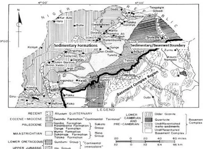
Geology: The geology of the Sokoto basin has been described by Kogbe (1989), Anderson and Ogilbee (1973), and Offodile (2002), mostly focussing on the sedimentary part and giving a brief description of the basement complex part. Literature exists however, on the basement complex rocks elsewhere in Nigeria. Basement rocks dominate about 50 % of Nigeria’s surface area while Cretaceous and Cenozoic sediments cover the other 50% (Adelana, 2003).
According to Eduvie (2006) Hazell et al (1988), and Anderson and Ogilbee (1973), the basement complex of Nigeria lies within the Pan-African terrain with four broad lithological units as follows:
A polycyclic basement of migmatites and gneisses together with relics of ancient metasediments of schist, phyllite, and quartzite.
Younger low to medium grade metasediments and metavolcanics, which form distinct NNE-SSW trend within the migmatite-gneiss complex.
Syntectonic to late tectonic Older Granite suite which intruded both the migmatitegneiss and the metasediments.
Unmetamorphosed alkaline, calc-alkaline volcanic and hypabbysal rocks, which overlie or intrude the basement and sedimentary rocks.
GSJ© 2018
www.globalscientificjournal.com
GSJ© 2018
www.globalscientificjournal.com
Hydrogeology: The first important exploratory study in Sokoto basin was done by Anderson and Ogilbee (1973), who give a general description of the hydrogeology during a project to explore the artesian aquifers in the sedimentary part of the basin. Since then, a number of studies focussing on the hydrogeological characteristics, Oteze, 1979, Offodile, 2002, Adelana et al., 2006, Ndubuisi, 2007) and groundwater development (SARDA / WADROP, 1988, JICA, 1990, Graham et al., 2006) of the basin have been carried out. Groundwater in the crystalline rocks is generally available in small quantities (Chandra et al., 2012, Robins et al., 2013) and occurs within fractures and weathered rocks (Holland, 2012, Wyns et al. 2004). The fractures are sometimes open up to a depth of 91 m, but even so, yields to boreholes are relatively low and cause high drawdowns (Adams, 2009). The availability of groundwater in the crystalline basement rocks depends on the development of thick soil overburden or the presence of fractures that are capable of holding water. The storage of groundwater is confined to fractures and fissures (JICA, 1990) in the weathered zone of igneous, metamorphic and volcanic rocks, the thickness of which range from <10-60 m in arid and humid rain forest (MacDonald et al., 1995, Chimphamba et al., 2009).
Soils: The available detailed soil maps for Sokoto basin only cover the fadama (UNDP-FAO, 1969) and sedimentary parts (Sambroek and Zonneveld, 1971) of the basin. Due to lack of available detailed soil mapping of the basement complex region of Sokoto basin, this section is informed by the Harmonised World Soil Database (HWSD, 2012) and Soil Atlas of Africa (2013). Broadly, the soils within the catchment area fall within four major groups in the HWSD and Soil Atlas of Africa classifications. The major soil classes identified are: Lithosols, Lixisols, Plinthosols and Gleysols.
Landuse and vegetation: The catchment falls within the Sudan Savannah zone with vegetation consisting of short grasses characterised by thorny species (Kaltho et al., 1997) and a scatter of acacia species which are interspersed with herbaceous cover of annual grasses. A comparative analysis of vegetation density towards the northern part of Zamfara state (which includes the drier part of the study area) between 1962 and 1991 (ARCA, 1995) shows that increasing human pressures on land such as expansion of cropland, livestock overgrazing and cutting of trees for firewood has resulted in the loss of about 71 - 85 % of the natural vegetation (Hassan, 2000;).
GSJ© 2018
www.globalscientificjournal.com
When dry season is severe, most hand dug wells in the region dries up, leaving only deep hand dug wells to provide water at intermittent intervals for the rest of the year and at reduced yield. The only reliable source of water supply at this difficult time of the year is in the Fadama (wetland areas) where shallow hand dug wells provide water at low yields. The groundwater in the Fadama locations relatively easy to exploit and suitable for small scale development for domestic, livestock and irrigation, provided the rural population is small. However, the water in the fadama is being competed for between people and their livestock and as such, in some areas cannot be able to meet required demand. The water in the Fadama areas is also used for irrigation agriculture, with heavy manuaring / application of chemical fertilizers to grow vegetables and other dry season cash crops. The quality of the water is therefore highly compromised and may not be potable. Recent studies also explained that possible global increases in temperature and changes in precipitation patterns over the years have greatly affected the quantity and quality of water resources.
Sources of Water
The ultimate source of water on the earth’s surface is precipitation, usually water resources of a given area depends on the amount of rainfall received over that area. In Sokoto state, the rates of water loss due to evapotranspiration are enormous because of the longer hours of bright sunshine and higher mean air temperatures in the state. During the dry season, the rainfall is always less than the water need and plants have to draw upon the soil moisture reserve, thus, creating a soil moisture deficit.
The surface water sources of the region mainly the river Rima and its tributaries; the Sokoto, Zamfara and Ka. The tributaries rise in the Basement Complex area of the east and southeast and flow radially towards the west. The flow of the Rima and its tributaries is seasonal at the upper catchments (Basement complex areas) and perennial at the lower catchment (lower part of the sedimentary areas) before meeting the river Niger. Other surface water sources are the lakes such as that of Kware, Kalmalo, and Bodinga, and storage dams at Goronyo, Lugu and Shagari.
GSJ© 2018
www.globalscientificjournal.com
and southwest. In the tertiary area, the Gwandu and the Sokoto group formations (Dange and Kalambaina limestone) store a large quantity of water existing in the form of artesian wells that gives low-moderate yields. In the cretaceous area, the Gundumi/Illo and the Rima group formations (Wurno and Taloka formations) store large amount of water under water table and artesian condition that gives high-moderate yields.
Materials and methods
The methodology employed for this research starts with the desk study (i.e. literature review and study area identification) and simulation set up. Daily rainfall and daily maximum and minimum temperature records of Gusau meteorological station was obtained for 5 year period (2006 – 2010). The station is located in the basement complex area of the Sokoto basin. The overall study area (River Ka catchment) was estimated using the Shuttle Radar Topography Mission (SRTM) Digital Elevation Model (DEM) of Nigeria with 90 m resolution. Geological map including GIS layers is obtained from Nigerian Geological Survey Agency (NGSA), while the Harmonised World Soil Database (HWSD) was used to obtain the soil map, soil types and other soil hydrological characteristics for the study area. Topographic maps of Nigeria in addition to the geology and soil maps were used to identify the different landscape features and soil types at different locations within the catchment. Based on the understanding of the complex geology of the basement complex areas in the study area, the hydrological processes of the basement complex region are considered to be spatially non-uniform. Individual landscapes respond differently from one another depending on the vegetation, soil types, topography, land use and other surface landscape features. The study area was therefore divided into landscape units to be subdivided into smaller areas or sub-units based on the heterogeneity which determines their hydrological responses. In this research, six major landscapes, some of which are further sub-divided, are identified within the catchment. The landscapes are:
Built-up areas landscape
Cultivated landscape
Bare surface landscapes
Bare rock landscape
Forest landscape
GSJ© 2018
www.globalscientificjournal.com
After the landscape classification, simulations were run using the required parameters to represent the different variables identified on each landscape. For each of the major landscapes and sub-units, inputs were used to characterize their soil, regolith and landuse based on the features identified.
Results and Discussion
The simulations have been run for 5 years (2006-2010), representing the results of wet and dry years to see the variations of landscapes hydrological behaviour under wet and dry conditions. The simple water balance assumption for this paper consists of a catchment with precipitation as the only input and runoff, evaporation/evapotranspiration, groundwater outflow and abstraction (integrated in the model simulation) as the outputs. This can be expressed using the following equation in the context of climate-landscape influences as: ∆S = P - E - Ro - GWo ……….eqn. 1
Where ∆S = change in storage, P = precipitation, E = evaporation/evapotranspiration, Ro = runoff, and GWo = groundwater outflow
Table 1 represents the results of the water balance for five consecutive rainfall years
Table 1: Landscape units water balance for five years
No Conceptual Landscape
Total for Years (2006 – 2010)
Rain (mm) Runoff (mm) AET (mm)
Groundwater discharge / Outflow ( mm)
Change in Storage (mm)
1 Residential 1 4918 1096 3699 87 36
2 Residential II 4918 1095 3705 110 8
3 Bare Surface I 4918 2491 2467 0 -40
4 Bare Surface II 4918 2501 2685 0 -268
5 Forest I 4918 131 4775 0 12
6 Forest II 4918 162 4719 0 37
7 Bare Rock I 4918 894 1304 2540 180
8 Bare Rock II 4918 3443 1304 0 171
9 Cultivated I 4918 664 3628 449 177
10 Cultivated II 6296 1102 4112 957 125
11 Cultivated III 4918 664 3597 480 177
12 Cultivated IV 6296 1065 4097 1006 128
GSJ© 2018
www.globalscientificjournal.com
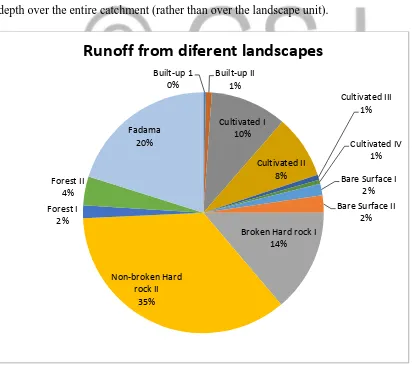
The summed contributions from the individual landscapes to the total water balance of the catchment over the 5 year period are recorded in Table1, showing the total output of runoff, AET and groundwater outflow. The total catchment values are calculated by summing the area weighted contributions of individual landscapes as presented in Error! Reference source not found.
Runoff contributions from different landscapes to the catchment-scale water balance
The results of total runoff contributed by each landscape for 5 years are given in Table 1. The depth of runoff from cultivated lands II and IV to the fadama and river is influenced by the run-on from the non-broken hard rocks added to the actual rainfall; also, the runoff from the fadama to the river is influenced by the run-on from all the five landscapes added to the actual rainfall.
Figure 3 shows the area weighted runoff totals recorded in Table 1, which are expressed as a depth over the entire catchment (rather than over the landscape unit).
Figure 3: Percentage 5 year runoff contribution from individual landscape unit Built-up 1
0%
Built-up II 1%
Cultivated I 10%
Cultivated II 8%
Cultivated III 1%
Cultivated IV 1%
Bare Surface I 2% Bare Surface II
2% Broken Hard rock I
14%
Non-broken Hard rock II
35% Forest I
2% Forest II
4%
Fadama 20%
GSJ© 2018
www.globalscientificjournal.com
In Figure 3, the non-broken rocks has the largest runoff contribution equalling about 35 % of the total runoff generated. This is not unexpected in view of the fact that the non-broken hard rocks occupy about 15 % of the total land area. In contrast, the broken hard rocks contribute only about 14 % of the total runoff in the 5 year water balance despite much runoff generated from this landscape due to lack of infiltration.
The fadama has the second highest individual landscape contribution of runoff in the water balance having about 20 % of the total runoff. The fadama receives large amount of run-on from other landscapes, some with three times bigger land area. The fadama area is smaller than some of the contributing landscapes in addition to the fact that it doesn’t contribute flow to any landscape; this results in high runoff generated from the fadama.
Despite the large total runoff from the two sealed surface landscapes (Error! Reference source not found.), their relatively small size (5 % of total land area) compared to other landscapes shows that their weighted runoff contributions to the overall catchment water balance is small (2 % each) compared to for example, the four cultivated lands with total land area of 30 %, which together, contributes about 20 % runoff (Error! Reference source not found.) in terms of per unit area contribution.
The effect of variations in soil depth of different landscapes can also be seen in the results of cultivated lands I to IV in Error! Reference source not found.. Although the total per unit area runoff from cultivated II & IV is higher than that of cultivated I & III, the area weighted runoff however is lower for Cultivated I and III due to their larger areas than Cultivated II & IV, despite the latter having additional run-on from non-broken hard rock.
The total runoff contributions from residential landscapes to the river are very small (Error! Reference source not found.), equalling only about 1 % of total runoff. It was observed during the fieldwork that most towns within the catchment are located close to the fadama because it serves as their source of water supply for irrigation and domestic use especially in the dry season.
GSJ© 2018
www.globalscientificjournal.com
Conclusion
This paper assesses the rainwater harvest potential of basement complex areas of Sokoto basin due to the fact that the weathered basement rocks are known to provide avenues through which water can be developed for community water supply. What is needed is a unified rational approach to water resources planning and development that takes cognizance of actual hydrological behaviours of different landscape units.
The paper identifies the exposed non-broken rocks, fadama and bare surface landscapes as having the high potential for excess runoff generation.
To ensure a sustainable water supply throughout the year for the local people, the paper stresses the need to apply methods of water conservation during excess for future use in the dry season. This involves taking advantage of the high levels of runoff not captured by natural recharge during rainy season for augmentation of groundwater resources through artificial recharge of aquifers in the deep weathered zones; or capturing and storing surface runoff by building small earth dams.
Artificial recharge is a method being used extensively in areas with similar hydrological condition around the world e.g. the development of sand dams in Kenya, Ethiopia, Namibia, Burkina Faso and India. It provides the cheapest form of new safe water supply for towns and small communities
GSJ© 2018
www.globalscientificjournal.com
References
Adams S (2009) Basement aquifers of southern Africa: Overview and research needs. In Rian T, Hans B, Shafick A and Leslie S (eds), The Basement Aquifers of Southern Africa Report to the Water Research Commission, WRC Report No. TT 428-09 August 2009
Adelana SMA, Olasehinde PI, Vrbka P (2003) Isotope and Geochemical Characterization of Surface and Subsurface Waters in the Semi-Arid Sokoto Basin, Nigeria, AJST, Vol. 4, No. 2
Anderson HR, Ogilbee W (1973) Aquifers in the Sokoto Basin, Northwestern Nigeria, with a description of the general hydrogeology of the region. U.S Geological Survey, Water Supply Paper 1757-L
Ayoade JO, Bamwo Y (2007) Changes in Annual Rainfall Characteristics in Nigeria between 1931-1960 and 1961-1990. The International Journal of Meteorology, Vol. 32, No. 318
Bello NJ (1997), Investigating the spatial pattern of the characteristics of the onset and cessation of the rains in Nigeria, GeoJournal 43: 113–123
Chandra S, Nagaiah E, Reddy DV, Ananda-Rao V, Ahmed S (2012) Exploring deep potential aquifer in water scarce crystalline rocks, J. Earth Syst. Sci. 121, No. 6, pp. 1455–1468
Chimphamba J, Ngongondo C, Mleta P (2009) Groundwater chemistry of basement aquifers: A case study of Malawi, In: Titus R, Beekman H, Adams S, Strachan L, (Eds.). Basement Aquifers of Southern Africa. WRC Report No. TT 428-09. ISBN 978-1-77005-898-9
Eduvie MO (2006) Borehole failures and groundwater development in Nigeria, Paper presented at a National Seminar held on the Occasion of Water Africa Exhibition (Nigeria 2006), Ikoyi Hotels & Suites, Victoria Island, Lagos on 15th November 2006
Ekpoh IJ, Nsa E (2011) The effects of Recent Climatic Variations on Water Yield in the Sokoto Region of Northern Nigeria, International Journal of Business and Social Science, Vol. 2 No 7
Graham W, Pishiria I, Ojo O, (2006) Monitoring Groundwater Quality for Small-Scale Irrigation: Case Studies in the Southwest Sokoto-Rima Basin, Nigeria, Agricultural Engineering International: the CIGR Ejournal, Vol.8
Hassan WA (2000) Biological productivity of sheep and goats under agro-silvo-pastoral systems in Zamfara Reserve in north-western Nigeria, Cuvillier Verlag, Goettingen, Germany Hazel JRT, Cratchley CR, Preston AM (1988) The location of aquifers in Crystalline and alluvium in Northern Nigeria using combined electromagnetic and resistivity techniques,
Quarterly Journal of Engineering Geology, Vol. 21, 159-175
GSJ© 2018
www.globalscientificjournal.com
Japan International Cooperation Agency (JICA) (1990), The Study for Groundwater Development in Sokoto State, Unpublished Report, Vol. II, Federal Ministry of Water Resources and Rural Development, Nigeria
Kaltho JB (ed), (1997) Gusau Master Plan: Final Draft Report. Department of Urban and Regional Planning, A.B.U Zaria, Nigeria
Kevin CN, Nicholas O (2010) Impacts of climate change on water resources in Africa: The role of adaptation. African technology policy studies network (ATPS)
Kun Z, Linus Z, William H, Mancang L, Hui, C. (2004). Quality issues in harvested rainwater in arid and semi-arid Loess Plateau of northern China, J. Arid Environ. 57(4):487-505
MacDonald AM (2005) Developing groundwater: a guide for rural water supply, ITDG Publishing, http://www.developmentbookshop.com
Macdonald OMJ, Thompson DM, Herbert R (1995) Sustainability of yield from wells and boreholes in crystalline basement aquifers, BGS Technical Report WC/95/SO
Mati BM, Matesu M, Oduor A (2005). Promoting rainwater harvesting Eastern and Southern Africa. The Relma experience. World Agroforestry centre: Kenya
Ndubuisi OL (2007) Assessment of Groundwater Recharge in Semi-Arid Region of Northern Nigeria: Using Soil Moisture Deficit Method. Journal of Engineering and Applied Sciences 2 (9), 1377-1382
Offodile ME (2002) Groundwater Study and Development in Nigeria, Mecon Geology and Engineering Services Ltd, Jos, Nigeria
Oteze GE (1979), The Hydrogeology of North-Western Nigeria Basin, In: Kogbe CA (ed), Geology of Nigeria, 2nd edition. Rock View, Jos
Pandey DN., Gupta AK, Anderson DM (2003) Rainwater harvesting as an adaptation to climate change. Current Science, 85(1), 6 – 59
Pereira LS, Oweis T, Zairi A (2002) Irrigation management under water scarcity,
Agricultural Water Management, Volume 57, Issue 3, 30 December 2002, Pages 175–206 Robins N, Jeffrey D, John F (2013) Groundwater supply and demand from southern Africa’s crystalline basement aquifer: evidence from Malawi, Hydrogeology Journal 21, 905–917, DOI 10.1007/s10040-013-0956-5
Sokoto Agricultural and Rural Development Authority (SARDA) / WADROP, (1988), Sokoto Fadama Shallow Groundwater Study. Unpublished Field Report Vol. II, Ministry of Agriculture, Sokoto
Sombroek WG, Zonneveld IS (1971) Ancient Dune Fields and Fluviatile Deposits in the Rima-Sokoto River Basin (N.W. Nigeria), Soil Survey Papers No. 5, Netherlands Soil Survey Institute, Wageningen
GSJ© 2018
www.globalscientificjournal.com
WHO and UNICEF (2012) Progress on sanitation and drinking water; 2012 update. Joint monitoring programme for water supply and sanitation, New York, NY: UNICEF and WHO