Proc. IAHS, 374, 93–99, 2016 proc-iahs.net/374/93/2016/ doi:10.5194/piahs-374-93-2016
© Author(s) 2016. CC Attribution 3.0 License.
Open Access
ater
Resources
Assessment
and
Seasonal
Prediction
Conjunctive operation of river facilities for integrated
water resources management in Korea
Hwirin Kim1, Cheolhee Jang2, and Sung Kim2
1Han River Flood Control Office, Ministry of Land, Infrastructure and Transport, Seoul, South Korea
2Hydro Science and Engineering Research Institute, Korea Institute of Civil Engineering and Building
Technology, 283 Goyangdae-ro, Ilsanseo-gu, Goyang-si, Gyeonggi-do, 411-712, South Korea
Correspondence to:Hwirin Kim (hydro@korea.kr)
Published: 17 October 2016
Abstract. With the increasing trend of water-related disasters such as floods and droughts resulting from climate change, the integrated management of water resources is gaining importance recently. Korea has worked towards preventing disasters caused by floods and droughts, managing water resources efficiently through the coordinated operation of river facilities such as dams, weirs, and agricultural reservoirs. This has been pursued to enable everyone to enjoy the benefits inherent to the utilization of water resources, by preserving functional rivers, improving their utility and reducing the degradation of water quality caused by floods and droughts. At the same time, coordinated activities are being conducted in multi-purpose dams, hydro-power dams, weirs, agricultural
reservoirs and water use facilities (featuring a daily water intake of over 100 000 m3day−1) with the purpose
of monitoring the management of such facilities. This is being done to ensure the protection of public interest without acting as an obstacle to sound water management practices. During Flood Season, each facilities contain flood control capacity by limited operating level which determined by the Regulation Council in advance. Dam flood discharge decisions are approved through the flood forecasting and management of Flood Control Office due to minimize flood damage for both upstream and downstream. The operational plan is implemented through the council’s predetermination while dry season for adequate quantity and distribution of water.
1 Introduction
The construction of dams in Korea was motivated by the main purposes of either water supply or power generation. The construction of hydropower dams started in the 1960’s. According to the 5-year economic development plan start-ing in 1962, the Seomjin River multi-purpose dam was the first to be built, and since 1972, multi-purpose dams such as the Soyang River and Andong dams have been built sub-sequently. Large-scale multi-purpose dams have been built continuously in order to meet the rapid increase of water de-mand, as well as to prevent flood damage, until the 1980’s. In the 1990’s, however, mid-scale multi-purpose dams like Buan, Miryang, and Hoengseong dams were built based on environmental considerations due to the objections from en-vironmental organizations. In addition, there have been dif-ficulties in the construction of multi-purpose dams, for
in-stance, the nullification of the Youngweol dam construction project, following the start of the construction of Jangheung (Tamjin) multi-purpose dam in 1996. However, the construc-tion of five new dams, including that of Buhang, is currently in progress.
Figure 1.Dam locations in Han river (from the Han River Flood Control Office website: http://www.hrfco.go.kr/eng/service.do).
Table 1.Dams for conjunctive operation per watershed.
Watershed Multi-purpose dam Hydropower dam Water supply dam Flood control dam Weir
Amount 17 8 14 2 16
Han River (17) Soyang River,
Chungju, Hoengseong
Hwacheon, Chooncheon, Uiam,
Cheongpyeong, Paldang, Gwesan, Doam
Gwangdong, Dalbang
Dam of Peace, GunNam
Ipo, Yeoju, Gangcheon
Nakdong River (24) Andong, Imha,
Hapcheon, Namkang Milyang, Guneui
Yeongcheon, Angye, Gampo, Woonmoon, Daegok, Sayeon, DaeAm, Sunam, Yeoncho, Gucheon
Changnyung Haman, Hapcheon, Changnyung, Dalsung, Gangjeong Goryeong, Chilgok, Gumi, Nakdan, Sangju
Geum River (5) Daecheong,
Yongdam
Sejong, Baekjae, Gongju
Seomjin River (8) Seomjin River,
Jooam (main), Jooam (Flood Control Reservoir)
Boseong River Soouh, Pyunglim Jooksan,
Seungchon (Youngsan River)
Others (3) Buan, Boryeong,
Table 2.The current status of dams in the Han River Watershed.
Category Name of Watershed Normal high Total storage Flood control Water supply Annual Energy
the Dam area water level capacity (million m3) (million m3yr−1) Production
(km2) (Elevation) (m) (million m3) (GWh yr−1)
Total 64 198 – 8104.8 1984.5 4885.5 2687.5
Multi-purpose Subtotal 9560 – 5736.9 1125.5 4712.5 1203.8
dam Soyang River 2703 193.5 2900.0 500.0 1213.0 353.0
Chungju 6648 141.0 2750.0 616.0 3380.0 844.1
Hoengseong 209 180.0 86.9 9.5 119.5 6.7
Hydropower Subtotal 50 883 – 1744.2 269.0 – 1507.0
dam Hwacheon 3901 181.0 1018.0 213.0 – 326.0
Chooncheon 4736 103.0 150.0 14.0 – 145.0
Uiam 7709 71.5 80.0 16.0 – 161.0
Cheongpyeong 9921 51.0 185.5 19.0 – 271.0
Paldang 23 800 25.5 244.0 7.0 – 485.0
Gwesan 671 135.6 15.3 – – 11.0
DoAm 145 707.0 51.4 – – 108.0
Flood Subtotal 7418 – 2701.6 2701.6 – –
control Dam of Peace 3227 – 2630.0 2630 – –
dam GunNam 4191 – 71.6 70.6 – –
Water Subtotal 154.4 – 18.7 – 40.6 –
supply Gwangdong 125 672.0 11.0 – 26.0 –
dam Dalbang 29.4 112.0 7.7 – 14.6 –
Agricultural Subtotal 374 – 14.5 – 132.0 –
dam Gangneung 109 – 12.7 – 26.0 –
Idong 93 – 21.0 – 34.0 –
Gosam 71 – 16.1 – 30.0 –
Geumkwang 48 – 12.1 – 21.0 –
Giheung(Singal) 53 – 11.7 – 21.0 –
for Food, Agriculture, Forestry and Fisheries (Korea rural community corporation). The conjunctive operation of each dam/weir in Korea is executed as per Table 1. Water sup-ply dams are categorized into Taebaek region, Pohang re-gion, Woonmoon, Ulsan rere-gion, Geoje rere-gion, Yeosu rere-gion, Pyunglim, etc.
2 Dams and weirs of the Han River watershed
The current status concerning the dams/weirs of the Han River watershed is shown in Table 2, for each dam and the watershed area, normal high water level, total storage capac-ity, dam type, dam height, etc.
There are 3 multi-purpose dams in the Han River Water-shed (Soyang River, Chungju, and Hoengseong dams) with
a total storage capacity of 5736.9 million m3. There are 7
hydropower dams in the Han River Watershed, with a
to-tal power generation capacity of 494.8 MW yr−1.
Gwang-dong and Dalbang dams are water supply dams, providing 41.0 million m3yr−1. There are five agricultural reservoirs
with over 10.0 million m3of effective storage capacity in the
Han River Watershed, providing a water supply of 132.0
mil-lion m3yr−1. The dam of Peace and GunNam flood control
reservoir are flood control dams. The flood control capacity
of the dam of Peace is 2630.0 million m3. Agricultural
voirs like Gosam, Idong, Giheung, and Geumkwang reser-voirs are located in the Ansung-Cheon upstream watershed.
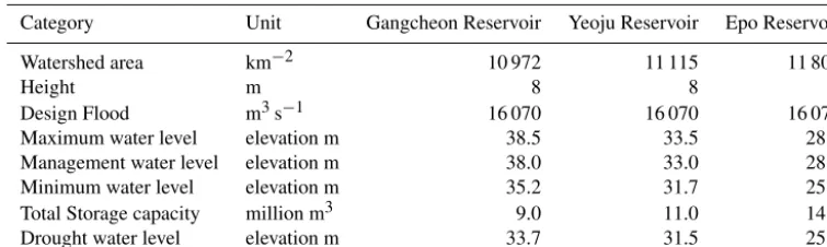
As shown in Table 3, 16 multi-purpose weirs are built na-tionwide. There are 3 weirs in operation in Han River Water-shed. The Gangcheon, Yeoju, and Ipo weirs have been built and are currently in operation in the Han River watershed, thus allowing to secure water and to prevent the lowering of the groundwater level.
3 The conjunctive operation of dam and weirs
mea-Table 3.Current status of weirs in the Han River Watershed.
Category Unit Gangcheon Reservoir Yeoju Reservoir Epo Reservoir
Watershed area km−2 10 972 11 115 11 803
Height m 8 8 6
Design Flood m3s−1 16 070 16 070 16 070
Maximum water level elevation m 38.5 33.5 28.5
Management water level elevation m 38.0 33.0 28.0
Minimum water level elevation m 35.2 31.7 25.3
Total Storage capacity million m3 9.0 11.0 14.0
Drought water level elevation m 33.7 31.5 25.0
sures considering the overall flood situation of a given basin, including weather and river conditions, as well as the storage capacity of the relevant dams and weirs. For example, the FCO directs the facility managers to use the storage volume of each facility down to the lowest operating water level, for flood control. During the drought season, facility managers operate according to the conjunctive plan of operation. Based on the site-specific Flowing Water Volume for River Mainte-nance (River Act Article 51), which can represent the state of these sites in terms of river discharge, the FCO instructs facility managers to take the necessary measures to prevent a potential situation of drought. In this sense, the FCO consid-ers all factors contributing to the water balance of the entire basin such as climate and river conditions, storage capaci-ties of dams and weirs, and the levels of usage of agricultural reservoirs. In addition, storage is also used to secure clean water through the improvement of the quality of river water. In order to establish good cooperation between the rel-evant organizations related to the utilization of water re-sources, and to set the basic criteria necessary for their con-junctive operation, the Regulation Council for the conjunc-tive operation of dams and weirs, comprising the central council and a local council for each watershed (Han River, Nakdong River, Keum River, Yeongsan River) discuss and establish agreements on a regular basis. Central council is held in February every year, each watershed’s council is held every December. The council consists of government orga-nization, local governments, facility managers and special-ists from private sector related with water management. The council works out conjunctive operation plan, decides ters concerning its change and assessment and other mat-ters needed for effective conjunctive operation and mediates opinions of stakeholders related with conjunctive operation. For example, Han River Regulation Council are consisted of three representatives from Ministry of Land, Infrastruc-ture and Transport, one representative from Ministry of Envi-ronment, five representatives from Local Governments, three representatives from each Dam operation Company and six specialists (Fig. 2).
The Minister of Land, Infrastructure and Transport can limit the usage by the users or control the permitted levels of
water, in case the streamflow is under any of the conditions below, affecting the downstream management:
1. Difficulty to ensure in-stream flow according to the standard limit;
2. Possibility of negatively affecting the public benefits if the permitted water levels are not controlled due a pro-longed drought;
3. If water users cannot use the water within the expiry date or if they have used less than the quota permitted by the Decree of the Ministry of Land, Infrastructure and Transport;
4. Difficulties using other allowed streamflow.
The adjustment of the permitted water, must be deliber-ated by the National River Management Commission. Be-fore adjusting the permitted water, a Regulation Council for streamflow can be formed and act according to the residents’ opinions, according to the presidential decree. The Regula-tion Council is under the relevant Flood Control Office, at the Ministry of Land, Infrastructure and Transport, and it is formed with less than 20 members including one chairman.
Chairperson (HRFCO)
Ministry
Ministry of Land, Infrastructure and
Transport
Han River Flood Control Office
Seoul Regional Construction Management Administration
Ministry of Environment
Local Government
Seoul
Incheon
Gyoungi
Gangwondo
Chungbuk
Facilities Manger
K-water
Korea Hydro&Nuclear Power corporation
Korea Rural Community corporation Specialist(6) Secretary : members(2)
Figure 2.Regulation Council for the conjunctive operation of dams/weirs Council(18): MOLIT(3), MOE(1), Local Government(5), Dam operation(3), Specialist(6).
4 Operation of flood handling dam/weir and the case of 2006
The water level of dams is limited during the flood season in order to ensure flood control. A restricted water level is maintained for 3 months from 21 June to 20 September. The total flood control capacity of the Han River watershed is
1461.1 million m3. According to multi-purpose dam control
regulation, article 14, when the dam level needs to be low-ered below the flood season restricted water level, and at-tending the flood situation up and downstream, it is possible to set a discharge whose amount and time are to be approved by the General Director of Flood Control Office, Ministry of Land, Infrastructure and Transport. The Design Flood Level defines a dam’s maximum level that can be observed during flood control. Normal high water level is the maximum wa-ter level that can be observed in the segment that is utilized for water supply. Restricted Water Level for the flood season is the level that has been set in order to ensure flood control during the flood season, and it is the maximum level to main-tain when there is no flood inflow. Regarding the dams for which there is no set Restricted Water Level, a normal high water level sets the reference. Minimum Storage Level is the lowest level at which the dam’s water can be used. The flood control capacity is the storage capacity between the dam’s Design Flood Level and Restricted Water Level for the flood season.
The procedure for discharge at multi-purpose and hy-dropower dams during the flood season is as follows: the dam manager requests approval for according to the discharge
Figure 3.Flood control by Chungju dam in 2006 case.
183.9
232.5 253.1 267.9
291.4 287.5 1,033.9
552.6
166.6 186.1
148.3
134.6 145.7
168.1 168.7
199.1
182.1 175.1 162.3
142.1 144.8 131.6 127.7
50.0 250.0 1250.0
Jan 2013
Feb Mar Apr May Jun July Aug Sep Oct Nov Dec Jan 2014
Feb Mar Apr May Jun July Aug Sep Oct Nov
A
ve
ra
ge
o
ut
fl
ow
(
㎥
s
)
(소양강+충주+횡성)기본계획량 (소양강+충주+횡성)방류량 (소양강+충주+횡성+화천)방류량
- Applying extreme drought (no precipitation) - 200 years drought (low flow) frequency
(Soyang+Chungju+Hoengseong) plan
Soyang+Chungju+Hoengseong outflow (Soyang+Chungju+Hoengseong+Hwacheon) outflow
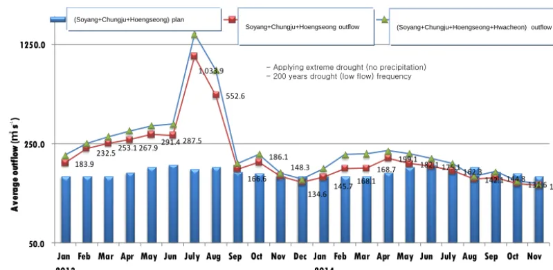
–1
Figure 4.Providing real water demands by considering drought status and conjunctive operation.
beginning and the end stages of flood control, as well as dur-ing the maximum discharge (complete closure) at the mov-able weir’s control floodgate. As aforementioned, the water level in the dam is controlled during the flood season in order to ensure flood control capacity.
Recently, a pre-release has not been executed because the water level of Soyang River, Chungju, Hwacheon, and Ho-engseong dams has been maintained below the restricted water level. Thus, we would like to present the case of 2006, which is remembered as the most urgent and diffi-cult dam operation performed during the flood season. The flood of July started with Ewiniar typhoon proceeding north-ward tonorth-wards the Korean peninsula. Ewiniar dissipated when it reached the land, but the vapors within developed a sea-sonal rain front causing considerable rain to fall in the Han river watershed on 12 July. For this reason, the entrance to Jamsugyo Bridge, over the Han River was prohibited. The re-lease began at the Chungju dam, on the Namhan River to en-sure the security of the dam and the downstream area (Hwirin Kim et al., 2015). Due to continuous a rain front and
local-ized heavy rain, at 02:15 LT (GMT+9) on 16 July, K-water
requested the discharge of Chungju dam to be increased from
08:00 LT from 3000 to 5000 m3s−1. Five hours later,
con-cerned with the integrity of the Chungju dam, a request was
made to increase the discharge to 10 000 m3s−1. However,
catastrophic effects in Yeoju and Seoul (Han River) areas were predicted in the case of the Chungju dam discharging at
10 000 m3s−1when it was below the restricted water level.
Considering the status downstream, the release had to be de-layed. At 13:00 LT, K-water received an approval request for a discharge at the Chungju dam. The decision was intensely discussed between upstream and downstream regions’ coun-terparts. The dam upstream area requested increasing its dis-charge amount to avoid increasing to water level at the dam. An inundation of 500 households was anticipated, with 1500
people in the need to evacuate urgently. In contrast, in the downstream area of the dam, 51 households had already been inundated, and 163 people had been evacuated. How-ever, 20 000 people were to be evacuated if the river level increased. For this reason, they requested decreasing the dis-charge amount. With the dam upstream area requesting an in-creased discharge, and the dam downstream area requesting a decreased discharge, Han River Flood Control Office, from the Ministry of Land, Infrastructure and Transport started re-vising the best possible discharge amount attending to the dam’s integrity. The safety at the Chungju dam was top prior-ity. Furthermore, they assessed the constantly changing state of flood in the dam upstream and downstream areas in order to avoid later inundations. Flood forecasting based on various scenarios was established and, accordingly, they reported to K-water on the best amount and period of discharge, follow-ing on discussions with decision makers (at 15:00 LT). For-tunately, the expected result was very accurate, and, at 144 m the maximum water level of Chungju dam did not lead to an emergency situation (08:00 LT), 1 m only from the Design Flood Level (145 m, see Fig. 3, Hwirin Kim et al., 2006).
The Jamsugyo Bridge was inundated during six days and emerged at around 04:10 LT on 21 July. The highest flood since the 1990’s flood was successfully handled. If there was more rainfall, if the flood forecasting was not accurate or the dam operation improper, 2006’s flood may have had catas-trophic consequences such as those of 1990.
5 Preventing water shortage with dam/weir management and the case of 2015
rele-vant offices took place. The first meeting of relerele-vant offices was attended by the Water Resources Development Divi-sion, Ministry of Land, Infrastructure and Transport, the Han River Flood Control Office, Ministry of Land, Infrastructure and Transport, the Ministry of Environment, the Ministry of Agriculture and Forestry, the Chief of forecasting con-trol division, the Han River Flood Concon-trol Office, the Min-istry of Land, Infrastructure and Transport, K-water, Korea Rural Community Corporation, and Korea Hydro & Nuclear Power Co., Ltd in 4 March 2015. In the meeting, they agreed to execute conjunctive operations at the hydropower dams in order to lengthen water supply for a longer period. Con-cerns were expressed over the decrease of agricultural wa-ter from Soyang River and Chungju dams due to rainfall
shortage. Keeping the minimum discharge (124 m3s−1) of
Paldang dam and considering Hwacheon dam’s electricity release, they decided to decrease the discharge amount of Soyang River and Chungju dams, and established a coop-erative structure to share data between Korea Hydro & Nu-clear Power Co., Ltd. and K-water for conjunctive operation (Fig. 4).
Secondly, the Regulation Council for streamflow of the Han River Watershed took place. It approached regulations and handling the water intake according drought stage. In-take limitations were approved over a range of levels, and natural intake control through the promotion of water sav-ings is being handled by K-water per agreed. Local gov-ernment showed interest and requested cooperation for joint countermeasures. The majority voted in favor of intake reg-ulations; and the conditional approval regarding the flexible intake limitation was to collect opinions from the Regulation Council. Intake limitation depending on the situation profile was determined and adopted.
6 Conclusions
Best efforts have been made in guaranteeing the facility man-ager’s rights when it does not concern water management, not disturbing the public benefits, and giving all citizens an
even usage benefit of water resources by decreasing damages caused by flood, water shortage, and the worsening of water quality, as well as promoting the downstream maintenance of functional usage through downstream facilities’ conjunctive operation such as heightened agricultural reservoirs, dams, and weirs. Recently, the Regulation Council for Streamflow and Regulation Council for Conjunctive Operation for Dams and Weirs held meetings to assess various drought alleviation measures including adjusting dam discharge level, building response guildelines and action plans, and imposing a quota on water intake. Emergency duty is also in operation to stand ready for different emergency scenarios.
The current dam storage rate in Korea is below average; therefore, the country needs to handle drought and flood at the same time. Conjunctive operation of dams and weirs is urgently needed now more than ever. In order to protect lives and property, the government needs to be alert at all times and must handle the situation wisely with the newest forecasting systems and based on the know-how of several years.
7 Data availability
The data that support the findings of this study are available from the corresponding author upon reasonable request.
References
Hwirin, K. and Jaehwa, N.: The July 2007 Flood Characteristics and Future Counterplan, Korean Society of Civil Engineering, 54, 128–136, 2006.