New Zealand Journal of Ecology(1994)18 (1):51-64 ©New Zealand Ecological Society National University, Canberra, ACT 0020, Australia.
DUNE SLACK VEGETATION IN SOUTHERN NEW ZEALAND
__________________________________________________________________________________________________________________________________ Summary:A range of slack vegetation in southern New Zealand was described by detailed sampling of four dune slacks, contrasting in topographic situation and in vegetation. Comparison is made with a slack previously sampled on Stewart Island. The five slacks differed markedly in the plant communities present. One slack, where there was considerable peat accumulation, was dominated by the megaherbPhormium tenaxand the restiadLeptocarpus similis. In another, the peat was deep and had apparently accumulated over a long period; the vegetation contained the trunked sedgeCarex sectaand was similar in species composition to carr vegetation described from the region. These two slacks were predominantly native in species composition, though the EuropeanErica lusitanicawas a component at the second. The other two slack sites were on substrate largely comprising sand; the vegetation was shorter, and included a mixture of native and exotic species. Many of the exotic species found in these sites have been recorded in European slacks.
Communities were defined by Cluster analysis. With rare exceptions, each plant community was specific to one or another of the five sites. Even the few community/site overlaps were in the vegetation of the surrounding dune areas, not of the slack itself. The communities within a site generally formed discrete zones, related to small differences in elevation.
The environment was characterised in terms of elevation, water table level, and soil salinity
(chloridity), organic content, pH, physical texture and fertility (assessed by bioassay). There were varying amounts of organic matter accumulation, but the mineral part of the substrate was almost pure sand throughout, except that at one site a stream had brought in silt. In three of the sites, the mineral base was below high tide level. The water table fluctuated through the year, with the same pattern as described for Northern Hemisphere slacks. Chloridity was low, but varied through the year. Some features of the yearly variation could be related to weather events.
It is concluded that slacks in the area show considerable variation in vegetation, much of which can be correlated with peat accumulation.
__________________________________________________________________________________________________________________________________ Key words:Chloridity; fen; New Zealand; salinity; sand dune; slack; water table.
Introduction
Slacks are damp or wet depressions between coastal dunes, where the ground water is often close to the sand surface, and is above it for part of the year (Tansley, 1939; Gitay and Agnew, 1989). They form where sand loss has been limited at some time by the level of the water table. The environment contrasts with that on the adjacent dunes, and fluctuates through the year, with standing water in winter, but possible drought stress in summer. In contrast to salt marshes, sea-water influence is low.
The vegetation and environment of slacks have been of interest to ecologists throughout the world, e.g., in Europe (van der Maarel and Westhoff, 1964), Britain (Crawford and Wishart, 1966), South Africa (McLachlan, Ascaray and du Toit, 1987) and North America (Tyndall and Levy, 1978). Slack vegetation
Sites
Aramoana
The dune/slack/saltmarsh area at Aramoana, Otago harbour (170°42.5' E, 45°47' S) lies behind an estuary bar (Partridge and Wilson, 1975). There is a series of parallel, low fossil sand dunes, of Holocene age, probably < 6000 years B.P. (C.A. Landis and P.D. McIntosh,pers. comm.). The slack surveyed lies between two such sand ridges, and is closed to seawater ingress at both ends. Depressions beyond the two ridges are open to the estuary, and contain salt marsh. The vegetation of the slack is dominated by the tall liliaceous (s.l.) herbPhormium tenax1.
The slack is mentioned by Johnson (1992).
Measley Beach
The slack, 60 km southwest of Dunedin (170°00' E, 46°15' S) occurs in a long depression between the fixed rear dune and the hillside, the latter apparently a very old dune, confirming the depression as a slack, be it an ancient one. The vegetation isc. 2 m tall, with the trunked sedgeCarex sectavisually predominating. Species composition is
predominantly native, except for the presence of Erica lusitanica, an exotic from Southwest Europe.
Toko Mouth
The small slack examined, 55 km southwest of Dunedin (170°03' E, 46°14' S), is entirely
surrounded by high dunes. The dunes are dominated by the exotic dune builderAmmophila arenaria, but in a few places the native dune builder
Desmoschoenus spiralisis still present. The vegetation of the slack comprises a low turf, with a close mixture of native and exotic species, between scattered clumps ofJuncus gregiflorus, Carex virgataandIsolepis nodosa(=Scirpoides nodosa). There is evidence of rabbit browsing.
Westwood
The slack, 12 km southwest of Dunedin city centre (170°22' E, 45°56.5' S) is a small and shallow depression towards the rear of a sand plain behind the main dune ridge. The dune vegetation is largely exotic, but natives are significant in the slack itself. Rabbit browsing is again in evidence.
1Nomenclature follows, in order of priority, Stace (1991), Webb, Sykes and Garnock-Jones (1988), Connor and Edgar (1987) and references therein for higher plants, Sainsbury (1955) for mosses and Hamlin (1972) for liverworts.
Mason Bay, Stewart Island
Described by Sykes and Wilson (1987), this site was included in the vegetation analyses to make the communities produced as general as possible from the available data.
Methods
Vegetation sampling
In each site a sample area was delimited, to cover the range of variation in the slack (or the complete slack when small), and to follow what we name the Sykes Principle: ‘Always sample into the next community’.
The vegetation physiognomy, and the scale of the community pattern, were quite different at the five sites. In order to perform effective sampling, it was necessary to use quadrat sizes appropriate to the vegetation. Therefore, a 0.2x0.2 m quadrat was used at Toko Mouth and Westwood (80 quadrats at each), and a circular quadrat of up to 1 m radius, sampling the closest seven species, at Aramoana and Measley Beach (60 quadrats at each). A 0.5x0.5 m quadrat had been used at Mason Bay. At each site, the quadrats were placed by restricted randomisation. Shoot presence of all macroscopic plant species was recorded.
In order to compare communities between sites, we analysed together all quadrats from all five sites sampled. This gave 428 quadrats in total. Cluster analysis was performed with the Jaccard measure of dissimilarity, and flexible sorting strategy (beta = - 0.25) (Clifford and Stephenson, 1975).
Soil and topography
After vegetation classification, the distribution of the communities was mapped onto each site. Four soil samples were then taken at random from each of the communities. (No samples were taken from the few communities not shewing a clear
topographic pattern, or limited in extent.) Soil characteristics determined were pH, organic matter (by loss on ignition at 500°C) and sand, clay and silt fractions in the inorganic fraction (by hydrometer). Soil fertility was determined by bioassay, mixing a soil sample with an equal volume of washed sand, placing in 9 cmx 9 cmx7 cm deep pots, and sowing 0.8 g ofLolium perenneseed per pot. The pots were sown on January 22 and shoot dry weight per pot
Compost No. 1 was included, and biomass results are expressed relative to this.
Elevation relative to the apparent high tide mark was measured at each quadrat. (This was intended to give some meaning to between-site comparisons, not as accurate calibration to tidal levels.) More detailed topography was measured along a transect through the sampled area to the sea. Within the slack, depth was recorded to the water table at vegetation-sampling time (within a few days for the four sites). The chloridity of the ground water was determined by silver chloride titration. Where there was peat, its depth was measured with a sampling probe.
Variation in water table and chloridity
At Aramoana and Westwood a series of perforated tubes was sunk into the substrate at intervals along a transect through the centre of the sampled area. The elevation of the water table was measured monthly from January 1991 to January/February 1992, and a water sample taken for chloridity determination as above.
Results
Vegetation classification: general
The vegetation grouping closely parallelled the sites sampled, all groups comprising
predominantly quadrats from one site. At our basic (arbitrary) level of six groups per site, the vegetation groups characteristic of Aramoana contained one quadrat from Toko Mouth and one from Westwood; the Measley Beach groups contained no quadrats from any other site; the Toko Mouth groups contained three Measley Beach quadrats and one Mason Bay (Stewart Island) quadrat; the Westwood groups included two Aramoana quadrats; the Mason Bay groups contained one Westwood quadrat. This represents only nine out of the 428 quadrats bearing
vegetation similar to that at another site.
At a more general level of classification, that of eight groups, quadrats from different sites were again distinct, with:
one Aramoana group,
one mixed Aramoana and Measley Beach group,
one Measley Beach group, one Toko Mouth group, two Westwood groups,
two Mason Bay (Stewart Island) groups.
Aramoana
Topography
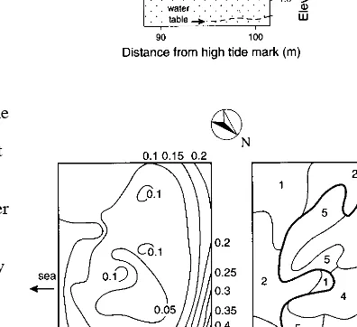
The slack sampled at Aramoana is surrounded by sand ridges. Levelling demonstrated these to be 0.25 - 0.5 m above the base of the slack, thus preventing the ingress of sea water and explaining its difference in vegetation from that in the neighbouring intra-ridge depressions, which are open to the sea and contain salt marsh. The topography within the slack is quite flat, though uneven on a small scale because of the growth form of theLeptocarpus similis(Fig. 1).
Water table
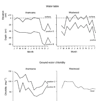
The water table at the time of vegetation sampling was almost horizontal, with some undulations that can be attributed to the slowness of lateral drainage through the peat, and slight indication of a lower table at the edges of the slack, under the two dune ridges (Fig. 1). Its depth varied through time (Fig. 2; in analysis of variance: F = 51.4, P < 0.0001) and between positions A-E (Figs. 1, 2; F = 149.0, P < 0.0001), but changes at different positions across the slack paralleled each other closely (Fig. 2). Water table depth was quite constant from January through to October, but then dropped. The decrease in November can be correlated with low rainfall in October and November that year (a total of 86.2 mm in Dunedin, 20 km away, compared with the long-term monthly norms of 131 mm). By the next January-February, water table depth had not recovered to its position at the same time a year earlier. The yearly-mean elevation of the water table relative to high-tide mark decreased from +5 cm above high tide level at Position D to high-tide level at Position E and -3 cm at Positions C, B and A. This confirms that drainage is away from the slack under the two ridges. At position A, the water table elevation was less variable than all other positions, probably reflecting the tidal influence there.
Chloridity
Overall, chloridity at Aramoana was somewhat higher than at other sites, an average of 164 mg l-1
through the main part of the slack at the time of vegetation sampling. Over the year, Position A, on the edge of the salt marsh, was clearly more saline than the others (F = 29.2, P < 0.000001), having a mean chloride value of 3 569 mg l-1, but with
Aramoana
Figure 1:The Aramoana slack: Profile of the site (top), profile of the area sampled for vegetation (middle), contour map (bottom left) and vegetation map (bottom right). Bold lines separate major groups of communities. 1 to 6 = Aramoana communities, W1 = Westwood community 1. The water table on the enlarged profile is at the time of vegetation sampling. A to E on the contour map are the positions of tubes for monthly water table sampling. Contours in metres.
__________________________________________________________________________________________________________________________________
Aramoana Measley Beach Toko Mouth Westwood
_____________________ ___________________ _____________________ _______________________
A A A A A A M M M M M M T T T T T T W W W W W W W
1 2 3 4 5 6 1 2 3 4 5 6 1 2 3 4 5 6 1 2 3 4 5 6a 6b
__________________________________________________________________________________________________________________________________
Blechnum penna-marina 1 3
Chiloscypus normalis 2 8 3 1 C
Gonocarpus aggregatus 1 4
Leptocarpus similis + 9 8 C
Lophlocloeasp. 2 4 5 3 4
Peltigerasp. + 1 2 + +
Racopilumsp. + 3
Blechnum minus 1 3 2 4 6 5 7 C C C
Coprosma propinqua + 2 C 9 1 4 6 2 + 4 +
Lepidosperma australe 3 4 C + 2 2 8 8
Ranunculus glabrifolius 4 4 2 + 2
*Anthoxanthum odoratum C 2 3 + + 5 1 1 2 +
*Cerastium fontanum 2 + 3 2 4 2 1
Hydrocotyle novae-zeelandiae + 4 + + 2 7 6 2 1 7 2
*Hypochaeris radicata 3 2 4 + 4 + 6 3
*Lupinus arboreus + 2 3
*Ranunculus repens 2 7 1 C
*Agrostis capillaris 2 2 2 + 3 5 + 8 8 6 2 1
Plagiochilasp. + 3 3 3 8 8 6 9 1
Phormium tenax 3 4 C C 9 C 2 7 9 8 2 + 6
*Trifolium repens + 8 6 8 6 5 6 3 3 + 3 7 1
*Poa pratensis C 1 2 2 + 8 + 2 6 5
*Juncus articulatus 4 + + + 2 6 2 + + C C
Hypnumsp. 2 2 1 + 5
Isolepis nodosa 1 6 4 8 4 + + 1 + 2
Carex virgata 2 + + + 2 + 1 4 1 4
Thuidiumsp. 1 2 2 9 9 C 1 C C + 2
*Holcus lanatus 8 8 6 + 1 3 7 + 9 9 C 7 3 9 C 7 C C 2 1
Astelia fragrans 3 4
Carex coriacea + 6 + 2 1
Carex secta 3 5 7 6 C
Coprosma lucida 4
Coriaria arborea 2
Eleocharis acuta 1 5 7
*Erica lusitanica + 5 C
Fuchsia excorticata 1
Hebe salicifolia C 7 +
Myrsine australis 1
Olearia avicenniifolia 3 1 2 3 + 8
Pittosporum tenuifolium 5 + 2
Pseudopanax colensoi 7
Pteridium esculentum 6 7 1 4
Weinmannia racemosa 1 8
Juncus gregiflorus 3 5 1 1 + 6 +
Marchantia berteroana 2 5 2 1 3
*Cirsium vulgare 5 1 2 +
Aneurasp. 2 4 1 +
Collemasp. 1 1 1
Epilobium brunnescens 3 1 2
*Festuca rubra 3 1 3 + +
Fossombroniasp. 6 9 1
Gnaphalium audax 2 +
Hydrocotyle heteromeria 1 + 6 1
Isolepis aucklandica 1 1 3 9 6
Isolepis cernuua + 2 1 4
*Juncus bufonius 2 6 1 4
Nertera setulosa + 3 3 6 2 2
Ranunculus acaulis + + 1 1
Ranunculus cheesemanii 5 2 1 +
Riccardiasp. 3 3 2 5 1
*Sagina procumbens 5 7 1 +
Tortulasp. 7 5 6 5 C 2
Trichocolea rigida 1 1 2 2 1
*Rumex acetosella 4 C C 3 2
Acaena novae-zelandiae + 4 2 7 1
*Agrostis stolonifera 1 8 8 4 7 C 8
*Carduussp. 5 + 2
*Dactylis glomerata + 1 1 +
*Galium aparine 5 + 1
Muehlenbeckia australis + C
Potentilla anserinoides + 7 8
Figure 2:Water table and ground water chloridity for 13-14 months in the Westwood and Aramoana slacks.
Position A from analyses, there were still significant difference between Positions B-E (F = 19.1, P < 0.000001), and variation between months (F = 9.7, P < 0.000001). Chloridity decreased until August-September and then rose until midsummer (Fig. 2). The low chloridity in winter would be expected from lower evaporation during winter, with input by seepage and salt spray occurring all year. There was no clear relation between water table height and chloridity.
Vegetation
Communities A1-A3 (Table 1), indicated among the Aramoana communities by the presence ofHolcus
lanatus, represent the sand ridge vegetation, occurring on the landward long dune ridge and also on the short dune ridge towards the estuary.
Measley Beach
Figure 3:The Measley Beach slack, arrangement as in Fig. 1. 1 to 6 = Measley Beach communities, T3 and T4 = Toko Mouth communities 3 and 4.
Community A3, with the cyperadLepidosperma australe, shrubCoprosma propinquaand megaherb Phormium tenaxalways present. The latter two species are typical of fens (Sykeset al., 1991), and indicate transition to the wetter communities. Indeed, bothHolcus lanatusfrom the drier communities andPhormium tenaxfrom the wetter ones are present.
Communities A4-A6 are in the slack proper. Leptocarpus similisandPhormium tenaxare almost constant. Vegetation height isc. 2 m. Community A4 occurs adjacent to both dune ridges. The soil has a high organic content. The community is species-poor, the best indicators being the liverwort Lophlocloeasp. and the cyperadIsolepis nodosa.
form is now well below this.
A stream, with waterc. 3 m deep, enters the area, but it is very slow-flowing, with no surface outlet, outflow being by seepage through the sand.
Levelling shews the steep bank on the landward edge (Fig. 3), which comprises the slope of a fossil (i.e., non-active) dune, and the shallower slope on the seaward edge where the slack ends in a fixed dune. The water table was very close to the surface across most of the slack, with standing water present at some points. It dropped slightly towards the fixed dune and markedly within it, indicating the direction of drainage below the dunes towards the sea. Mean chloridity at time of vegetation sampling was 35 mg l-1.
Vegetation
Communities M1-M2 at Measley Beach are the communities of the inland fossil dune bank. Community M1 has constantly the shrubHebe salicifoliaand frequently the brackenPteridium esculentum. It represents an early seral stage in succession to native forest, after disturbance. In M2, some parts are open scrub, related to M1, withHebe salicifolia, Pteridium esculentumand the small tree Pseudopanax colensoi. Other patches comprise low forest of the small treesCoprosma lucida,Fuchsia excorticata,Myrsine australisandPittosporum tenuifolium, with the megaherbAstelia fragrans below. The whole community is typical of secondary native forest.
Communities M1 and M2 are both seral to the climax native forest of the area. They might represent a salt-spray subclimax, but they probably reflect also some disturbance associated with the building of a road nearby.
The fixed dune bears two communities found more extensively at Toko Mouth. T3 occurs on the dunes at both Measley Beach and Toko Mouth (Figs. 3, 4); it is characterised best by the near-faithfulHydrocotyle heteromeria, but the more widespreadThuidiumsp. andHolcus lanatusare constant. T4 is characteristic of the outer slack at Toko Mouth and the slack edge at Measley Beach (Table 2), adjacent to the dunes;Nertera setulosais the most notable species. The soil on which these communities occur at Measley beach is somewhat higher in organic content and lower in sand content than where T4 occurs at Toko Mouth (Table 2).
Just below T3 and T4, on the seaward edge of the slack is an ecotonal community, M3. It contains species typical of the fixed dune, such asHolcus lanatus, but also slack species typical of M4-M6, such asBlechnum minus, Carex sectaand Phormium tenax.
Table 2:Soil characteristics of plant communities in four slacks in southern New Zealand. - = organic content too high for texture analysis to be performed. The bioassay index is based on J.I.P. compost No. 1 = 100.
_____________________________________________________________ Inorganic
Community pH Sand Clay Silt Organic Bioassay
(%) (%) (%) (%) index
_____________________________________________________________
Aramoana
A1 4.3 91.9 4.1 4.0 8.9 93
A2 4.2 91.4 5.5 3.1 41.5 83
A3 no samples
A4 4.3 - - - 53.2 94
A5 4.1 90.2 4.8 5.0 13.7 107
A6 5.2 - - - 63.7 82
Measley Beach
T3+T4 4.4 64.5 11.1 24.4 12.6 78
M1 5.1 77.4 2.7 19.9 6.4 90
M2 no samples
M3 4.5 38.0 21.4 40.6 6.5 83
M4 5.9 0.0 24.3 75.7 40.7 79
M6 5.9 0.0 35.6 64.4 39.6 82
M5 5.6 0.0 26.3 73.7 45.8 75
Toko Mouth
T1 5.2 89.3 4.5 6.2 7.3 80
T2 5.4 90.3 3.0 6.7 6.2 95
T5 4.9 89.1 3.5 7.4 7.6 91
T6 4.7 89.9 3.7 6.4 7.4 100
T3 no samples
T4 5.0 88.2 4.6 7.2 7.7 100
Westwood
W1 5.3 93.7 3.7 2.6 4.2 84
W2 no samples
W5 5.9 92.2 3.9 3.9 5.1 106
W3 5.7 93.1 3.7 3.2 3.2 91
W4 6.7 93.5 3.7 2.8 2.6 106
W6a 6.6 91.6 5.0 3.4 4.2 100
W6b 5.9 93.0 4.0 3.0 2.9 87
_____________________________________________________________
always as epiphytes on the base ofPhormium tenax leaves. The soil has higher pH, and the highest organic content. A notable difference from Communities A4 and A5 is the rarity ofIsolepis nodosa, common in the latter two.
Community W1, found otherwise on the dune slopes at Westwood, occurs on the estuary edge of the short dune ridge at Aramoana, with species such asHolcus lanatusandGalium aparine.
Measley Beach
Environment
Marchantia berteroanaandJuncus gregiflorus very common.Agrostis capillarisis notably infrequent. Fertility is lower than in other Toko Mouth communities (Table 2). Community T2 occurs on the steep NW slope, and again on the shallower SE slopes. It contains frequentAgrostis capillaris,Juncus bufoniusandRanunculus cheesemanii. On these lower slopes, organic content is even lower than in the other Toko Mouth communities, and pH the highest. Community T3 occurs as two quadrats on the inland dune slope; Hydrocotyle heteromeriais frequent. The composition and position of the community may relate to human use, since there is a vague track here.
Communities M4-M6 represent the slack proper, quite uniform in species composition, with high frequency ofBlechnum minusand the trunked sedge Carex secta, and mean vegetation heightc. 1.7 m.
Community M4 occurs on the deep peat adjacent to the bank. The stream is situated within this area.Coriaria arboreais common in one sub-community. M4 also occurs as a narrow band at the edge of the fixed dune at the seaward side of the slack. In both M5 and M6 the exotic shrubErica lusitanicais common, and also the native cyperad Lepidosperma australe.Community M5 occurs on the seaward side of M6, intermediate between it and M3;Phormium tenaxandEleocharis acutaare frequent, but in general the community is species-poor. Community M6 occurs in the middle of the slack. Shrubs of the normally arborescent species Weinmannia racemosaare common in this community. The community is again species-poor. None of the substrate factors measured (Table 2) distinguish between Communities M4-M6, but the geomorphology does, in that M4 occurs most consistently on the deepest peat, M5 occurs on shallower peat towards the dunes, and M6 between them.
The substrate of communities M4-M6 is peat, with a high water content. Cut off from the substrate, there is no sand content, but there is an appreciable content of silt and to a lesser extent clay (Table 2), presumably brought down from the hills in the stream.
Toko Mouth
Environment
This site is the nearest of the four to open sea (Fig. 4), with only one high dune ridge between it and the ocean. It is the closest to a typical slack in
geomorphological position, with high dunes almost all round it. The main slack plain is slightly below high tide level.
The water table was almost level, but at greater depth than at other sites. Mean chloridity at vegetation sampling time was 78 mg l-1. Organic
content was quite low in all communities, certainly lower than in most communities at Aramoana or Measley Beach. The mineral component was almost pure sand, with negligible silt and clay fractions.
Vegetation
Communities T1, T2 and T3 occur on the dunes surrounding the slack (Fig. 4). T1 occurs mainly to the south and east. In the areas of T1 to the south, Epilobium brunnescensis quite frequent, and
Figure 4:The Toko Mouth slack, arrangement as in Fig. 1. 1 to 6 = Toko Mouth communities,
Westwood
Topography
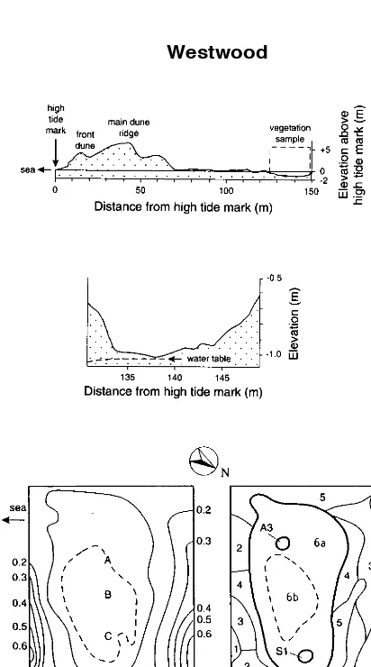
The slack itself is below high tide level (Fig. 5), 125-150 m inland. The Kaikorai estuary/lagoon is to the east, too far to exert any influence.
Soil organic content is consistently low. The mineral soil component is overwhelmingly sand, most of the apparent silt and clay probably being the unavoidable analysis artefacts of organic matter.
Water table
The water table at vegetation-sampling time shewed a very slight fall in elevation away from the centre of the slack (Fig. 5). Its depth varied with time
(F = 324.7, P < 0.000001) and position (F = 367.0, P < 0.000001). Standing water was present to a depth of 10 cm in the centre of the slack (Position B) intermittently during the winter (Fig. 2), but the water table, even in the bottom of the slack, retreated toc. 40 cm depth in summer. Depths of the water table at different positions followed each other closely (Fig. 2). The rise in water table from February to March can be related to the rainfall in February, 178 mm compared to the monthly norm of 61 mm. Similarly, the lower water table in November can be correlated with low rainfall the previous month (see above), though there was an unexplained increase in December. In absolute elevation (i.e., after compensating for differences in the elevation of the soil surface) water table at Position E was on average 4 cm above that at B.
Chloridity
Chloridity varied with time (F = 4.9,P= 0.00005), but was low overall (mean 77 mg l-1). The chloridity was not significantly different between positions (F = 0.57, ns), reflecting the distance from tidal influence. Chloridity rose in February, reflecting a storm on 1992 February 18-19, and resulting salt spray; it subsequently decreased.
Vegetation
Communities W1-W5 represent the surrounding sand dune and transitional communities.Holcus lanatusis almost constant through these communities.
Community W1 occurs on the raised ground to either side of the slack, inland and seaward.Carduussp. andGalium aparineare frequent, especially in the patch of the community at the inland side. This is the
only Westwood community whereLupinus arboreus
occurred.Agrostis stoloniferais absent, in contrast to
Westwood
Figure 5:The Westwood slack, arrangement as in Fig. 1. 1 to 6b = Westwood communities, A3 = Aramoana community 3, S1 = Mason bay (Stewart Island)
community 1. A to E on the contour map are the positions of tubes for monthly water table sampling.
Communities T4-T6 represent the slack proper. T4, with frequentNertera setulosa, occurs around T6 on the SE side. Community T5 occurs around T6 on slightly higher ground to the NW;Agrostis capillarisandHydrocotyle novae-zelandiaeare very common, in contrast to T4 and T6;Isolepis aucklandicais an indicator species. Community T6 occupies the lowest part of the slack. It comprises
two phases, withMarchantia berteroanaand
Juncus gregiflorusfrequent in some patches,
all other Westwood communities. Soil fertility is the lowest of the Westwood communities. Community W2 occurs also around the edge of the sampled area, but on slightly lower ground than W1. The megaherb Phormium tenaxis characteristic of W2. Organic content is slightly higher than in the other Westwood communities, but still lower than in any community in any of the other sites. In W3,Rumex acetosellais constant.Poa pratensisis most common here among the Westwood communities. The community is inter-mediate in position between Communities W1 and W4. In W4,Rumex acetosellais common too, but the community is species-poor, withCirsium vulgarethe nearest to an indicator species. The community occurs around, and adjacent to, Community W6, the slack proper. Also adjacent to W6 is W5, with Rumex acetosellaabsent, butHypochaeris radicata, Acaena novae-zelandiaeandRumex crispusmore common than elsewhere.
Community W6 is the slack proper.Holcus lanatusis rare, in contrast to communities W1-W5. Juncus articulatusis constant,Agrostis stolonifera andPotentilla anserinoidesfrequent. Although the community is quite uniform, because of its
considerable extent it can usefully be divided in two: W6a and W6b. Subcommunity W6a surrounds W6b, withTrifolium repensfrequent. W6b is in the lowest part of the slack;Ranunculus repensis constant, and Hypnum cupressiformcommon.
Discussion
Slack geomorphology
The sites differ in their geomorphology. Toko Mouth and Westwood are very close to the classical slack landform, of a depression bounded by sand ridges. At Aramoana, the site is indeed bounded on all sides by sand ridges, but they are low and sand deposition is not active; moreover, there is saltmarsh nearby. Drainage out of the area is downwards through the sand, conforming to the slack concept. The Measley Beach slack is between sand ridges, but the one inland of the sampled slack is apparently thousands of years old. A stream enters the area but does not leave, water percolating through the sand, again confirming the site as a slack rather than streambank.
All four sites are quite clearly, from their orientation and from the dunes around them, primary slacks, i.e., depressions between successively-formed sand ridges (Williset al., 1959), in contrast to the apparently secondary slack at Mason Bay (Stewart Island), formed in a blow-out (Sykes and Wilson, 1987).
The substrate is similar in all four slacks, a
moderately-fine siliceous sand. However, there are varying degrees of peat accumulation. The Mason Bay slack has low-organic soil, up to 5% (Sykes and Wilson, 1987). The composition of the mineral soil component in these slacks is probably even more predominantly sand than the analyses indicate, since it is technically difficult to exclude remnant organic matter from the fine fractions. A sand base is typical of slacks, expected from their origin (e.g., Tyndall and Levy, 1978).
The Measley Beach slack has considerable formation of peat, but this also is known in slacks elsewhere, e.g., 0.38 m depth in a slack described by Sims, Wickware and Cowell (1987). However, this does emphasise its status as an intermediate on a slack to fen gradient.
Water regime
Water table elevations are related to weather patterns, but not simply nor in the same way in all slacks. The notably high rainfall in 1991 February (close to the highest ever recorded for that month) is reflected clearly in the elevation of the water table at Westwood, but not at Aramoana. This can be attributed to surface outflow from the Aramoana site when standing water reachesc. 20 cm depth, because of the low dune sills.
Species of slacks are often tolerant of waterlogging (Schat, 1984; Seliskar, 1988), suggesting this may be a limiting factor in the slack environment. The strong relation between
community zonation and elevation that we found supports this (cf. Studer-Ehrensberger, Studer and Crawford, 1993; Noest, 1994). Our 13-month sampling (Fig. 2) demonstrated that intermittent winter waterlogging is a feature of the slacks of southern New Zealand, with water table fluctuations similar to those recorded in slacks in Europe (e.g., van der Laan, 1979; Gitay and Agnew, 1989).
Soil chemistry
The lowest yearly-mean chloridities at Aramoana (Position E: 72 mg l-1; D: 89 mg l-1) were similar to
the yearly mean of 77 at Westwood, and the sampling-time mean of 78 mg l-1at Toko Mouth.
This is far below the chloridity of sea water: the open-sea norm is 18 000 - 19 000 mg l-1, and we
measured 15 230 mg l-1for local shore seawater. To
This suggests there is still an impact of sea water at the slack sites, a conclusion strengthened by the seasonal variation in chloridity, and in one case the ability to tie this to a storm event. The lower chloridity at Measley Beach (35 mg l-1) can therefore
be seen as reflecting its distance from the sea, and perhaps the sheltering effect of the hill behind. Van der Merwe and McLachlan (1991) found an average of 1400 mg l-1in South African slacks.
Chloridity at Aramoana Positions C (201 mg l-1)
and B (162 mg l-1) was higher, suggesting seepage
from the saltmarsh beyond the low dune ridges. Dougherty, Mendelssohn and Monteferrante (1990) found increased growth after treatment of a Louisana slack with fertiliser, especially N and perhaps P. In contrast, the bioassay here shewed little nutrient growth limitation in comparison with fertile soil, and the relatively small difference in fertility within the sites.
Species
The majority of exotic species present in the slacks are also found in slacks in Europe:Agrostis capillaris,A. stolonifera,Bellis perennis,Cerastium fontanum,Cirsium vulgare,Crepis capillaris, Festuca rubra,Holcus lanatus,Hypochaeris radicata,Juncus articulatus,J. bufonius,Leontodon taraxacoides,Poa pratensis,Prunella vulgaris, Ranunculus repens,Rumex crispus,Sagina procumbensandTrifolium repens(Crawford and Wishart, 1966; Gitay and Agnew, 1989; van der Laan, 1979; Ranwell, 1960; van der Maarel and Westhoff, 1964; Williset al., 1959).Hypnum cupressiformeand possiblyPotentilla anserinoides are natives conspecific with the common European slack species. Most of these species are generalists, although the combination of them would be more restricted.
Plant community attributes
It was impossible to use the same sampling unit in all sites because of the varying spatial grain of the vegetation. However, the conclusion that different communities are found in different sites cannot be attributed to this, for even between pairs of sites with identical sampling scheme there was very little community overlap. Indeedallthe cases of
community overlap between sites were between sites with different quadrat sizes. We can therefore see the sampling schemes as a result of the vegetational differences, not the reverse.
The two taller-vegetation slacks are
predominantly native, except on the higher, drier, sandy areas. The two shorter slacks contain many
exotics. This indicates greater invasion resistance of the taller communities, though there may also be fewer exotics in the species pool that are adapted to wetter conditions. It is general in N.Z. and world-wide for dry areas to be those particularly invaded by exotics (Dansereau, 1964; Williams, 1980; Wardle, 1985; Jackson and Roy, 1989).
On many New Zealand dune systems, slacks seem to be absent (Johnson, 1992), e.g., at Cole Creek on the west coast of South Island (Sykes and Wilson, 1991), probably because of the free-draining sand, and the physiognomy of the dunes and beach.
Vegetation relations
The vegetation at Measley Beach is similar to part of the carr described by Sykeset al. (1991), especially in the physiognomic dominants such as Carex secta,Phormium tenaxandBlechnum species. There is especial similarity between communities M3-M6 at Measley Beach and Communities ‘4’ and ‘5’ in the carr (Sykeset al., 1991). Indeed the latter species are prominent in the photograph of carr community ‘5’ in Fig. 4 of Sykeset al. (1991). In Aramoana community A3, the shrubCoprosma propinquaand megaherb Phormium tenaxare always present. These species are also found in other damp communities of the region such as carr (Sykeset al., 1991). Here, community A3 is transitional between dune and slack. Another species typical of A3 is
Lepidosperma australe, found in both wet sites and in heathland (Johnson and Brook, 1989). Others have noted the similarity between slack vegetation and that of inland fens (Simset al., 1987).
There is quite remarkable distinction in vegetation between sites. There are only nine cases of quadrats being classified with those of other sites, 2.1%. Partridge and Wilson (1988) observed that even though many species are in common between saltmarshes of southern New Zealand, the species are assembled in different ways on different marshes. King, Wilson and Sykes (1991) similarly observed that in riverbank marshes, although many of the species are in common with marine marshes, they are rarely associated into the same
communities. This geographical variation is even more marked for slacks. All the cases of similarity between slack sites were in communities of drier areas, often the dune above the slack proper, emphasising the differentiation of the slack communities themselves. One reason for the variation may be that sites with different
and Westwood, sites with very different slack vegetation, were quite similar (Fig. 2). The four slacks are very different in soil organic content, the organic Aramoana and Measley Beach soils contrast-ing with the mineral substrate at Toko Mouth and Westwood. This may be largely a function of slack age. It results in marked vegetational differences.
The communities of the short slacks described here bear little relation to the list of slack species given by Cockayne (1928), though there are some obvious similarities with the taller-vegetation slacks: e.g.,Leptospermum scoparium,Phormium tenax, Coprosma propinqua. Part of this difference may be due to the age of the slack; that at Measley beach is clearly much older, and since the dunes at Aramoana are inactive the slack there is probably quite old too. However, it may be that the balance between slack vegetation types can be tipped by quite small changes in environment (cf. Studer-Ehrensbergeret al., 1993). This suggests the operation of a vegetation switch (Wilson and Agnew, 1992), perhaps with a positive-feedback mechanism between specific composition, vegetation height and peat formation.
Many previous slacks have been destroyed by ‘development’. In selecting our four sites to sample, we visited many others, and consulted botanists who had visited further sites. This gives us confidence, increased by the site descriptions in Johnson (1992), that our four sites both cover the range of slack vegetation in the south-east of South Island, and include some of the best preserved sites. Plant community descriptions provide a sound basis for assessment of natural values and hence conservation decisions. It is clear that conservation of the
Aramoana, Measley Beach and Toko Mouth slacks is a high priority.
Acknowledgements
SHR, HG and WMcGK acknowledge support from the Hellaby Indigenous Grasslands Research Trust. JBW thanks the Biology Department, Open University, for facilities whilst on study leave. We thank Mark Peters of the University Surveying Dept. for assistance with levelling at Aramoana. Tara Goodsell, of the Research School of Biological Sciences, ANU, prepared the figures.
References
Clifford, H.T.; Stephenson, W. 1975.An introduction to numerical classification. Academic Press,
New York, U.S.A. 229 pp.
Cockayne, L. 1928. The vegetation of New Zealand, 2nd edn. Engelmann Press, Leipzig, Germany. 456 pp.
Connor, H.E.; Edgar, E. 1987. Name changes in the indigenous New Zealand Flora, 1960-1986 and Nomina Nova IV, 1983-1986.New Zealand Journal of Botany 25:115-170.
Crawford, R.M.M.; Wishart, D. 1966. A multivariate analysis of the development of dune slack vegetation in relation to coastal accretion at Tentsmuir, Fife.Journal of Ecology 54: 729-743.
Dansereau, P. 1964. Six problems in New Zealand vegetation.Bulletin of the Torrey Botanical Club 91:114-140.
Dougherty, K.M.; Mendelssohn, I.A.; Monteferrante, F.J. 1990. Effect of nitrogen, phosphorus and potassium additions on plant biomass and soil nutrient content of a swale barrier strand community in Louisiana.Annals of Botany 66: 265-271.
Esler, A.E. 1969. Manawatu sand plain vegetation. Proceedings of the New Zealand Ecological Society 16:32-35.
Esler, A.E. 1970. Manawatu sand dune vegetation. Proceedings of the New Zealand Ecological Society 17:41-46.
Esler, A.E. 1974. Vegetation of the sand country bordering the Waitakere range, Auckland: the southern beaches.Proceedings of the New Zealand Ecological Society 21:72-77. Esler, A.E. 1978.Botany of the Manawatu district,
New Zealand. DSIR Information Series, No 127. Government Printer, Wellington, N.Z. 206 pp. Gitay, H.; Agnew, A.D.Q. 1989. Plant community
structure, connectance, niche limitation and species guilds within a dune slack grassland. Vegetatio 83:241-248.
Hamlin, B.G. 1972. Hepaticae of New Zealand. Records of the Dominion Museum 7 (19): 243-366.
Jackson, L.E.; Roy, J. 1989. Comparative ecology of annual grasses: native versus Californian habitats and populations.In: Huenneke, L.F.; Mooney, H. (Editors),Grassland structure and function: California annual grassland, pp. 81-91, Kluwer, Dordrecht, The Netherlands. 220 pp.
Johnson, P.N. 1992.The sand dune and beach vegetation inventory of New Zealand. II.South Island and Stewart Island.DSIR Land Resources, Christchurch, N.Z. 278 pp.
King, W.McG.; Wilson, J.B.; Sykes, M.T. 1991. A vegetation zonation from saltmarsh to riverbank in New Zealand.Journal of Vegetation Science 1:411-418.
McLachlan, A.; Ascaray, C.; du Toit, P. 1987. Sand movement, vegetation succession and biomass spectrum in a costal dune slack in Algoa Bay, South Africa.Journal of Arid Environments 12: 9-25.
Noest, V. 1994. A hydrology-vegetation interaction model for predicting the occurrence of plant species in dune slacks.Journal of
Environmental Management 40:119-128. Partridge, T.R.; Wilson, J.B. 1975. Plant
communities at Aramoana. In:The ecology of Aramoana, Otago Harbour, report 4. Dunedin Metropolitan Regional Planning Authority, Dunedin, New Zealand.
Partridge, T.R.; Wilson, J.B. 1988. Vegetation patterns in salt marshes of Otago, New Zealand. New Zealand Journal of Botany 26:497-510. Ranwell, D.S. 1960. Newborough Warren,
Anglesey. II. Plant associes and succession cycles of the sand dune and dune slack vegetation.Journal of Ecology 48: 117-141. Ranwell, D.S. 1972.Ecology of salt marshes and
sand dunes. Chapman and Hall, London, U.K. 258 pp.
Sainsbury, G.O.K. 1955. A handbook of the New Zealand mosses.Royal Society of New Zealand Bulletin 5:1-490.
Schat, H. 1984. A comparative ecophysiological study on the effects of waterlogging and submergence on dune slack plants: growth, survival and mineral nutrition in sand culture experiments.Oecologia 62:279-286. Seliskar, D.M. 1988. Waterlogging stress and
ethylene production in the dune slack plant, Scirpus americanus.Journal of Experimental Botany 39:1639-1648.
Sims, R.A.; Wickware, G.M.; Cowell, D.W. 1987. A study of coastal vegetation at a site on Hudson Bay near Winisk, Ontario.Canadian Field Naturalist 101:335-345.
Stace, C.A. 1991.New flora of the British Isles. Cambridge University Press, Cambridge, U.K. 1226 pp.
Studer-Ehrensberger, K.; Studer, C.; Crawford, R.M.M. 1993: Competition at community boundaries - mechanisms of vegetation structure in a dune-slack complex.Functional Ecology 7: 156-168.
Sykes, M.T.; Wilson, J.B. 1987. The vegetation of a New Zealand dune slack.Vegetatio 71:13-19. Sykes, M.T.; Wilson, J.B. 1991. Vegetation of a
coastal sand dune system in southern New Zealand.Journal of Vegetation Science 2: 531-538.
Sykes, M.T.; Wilson, J.B.; Lee, W.G.; Allen, R.B. 1991. A remnant New Zealand carr.Journal of Vegetation Science 2:209-216.
Tansley, A.G. 1939.The British Islands and their vegetation. Cambridge University Press, Cambridge, U.K. 930 pp.
Tyndall, R.W.; Levy, G.F. 1978. Plant distribution and succession within interdunal depressions on a Virginia barrier dune system.Journal of the Elisha Mitchell Scientific Society 94:1-15. van der Laan, D. 1979. Spatial and temporal
variation in the vegetation of dune slacks in relation to the ground water regime.Vegetatio 39:43-51.
van der Maarel, E.; Westhoff, V. 1964. The vegetation of the dunes near Oostvoorne (The Netherlands) with a vegetation map.Wentia 12: 1-61.
van der Merwe, D.; McLachlan, A. 1991. The interstitial environment of coastal dune slacks. Journal of Arid Environments 21:151-163. Wardle, P. 1985. Environmental influences on the
vegetation of New Zealand.New Zealand Journal of Botany 23:773-788.
Webb, C.J.; Sykes, W.R.; Garnock-Jones, P.J. 1988. Flora of New Zealand, Vol. IV. Botany Division, DSIR, Christchurch, N.Z. 1365 pp. Williams, P.A. 1980.Vittadinia trilobaandRumex
acetosellacommunities in the semi-arid regions of the South Island.New Zealand Journal of Ecology 3:13-22.
Willis, A.J.; Folkes, B.F.; Hope-Simpson, J.F.; Yemm, E.W. 1959. Braunton Burrows: the dune system and its vegetation. Part II.Journal of Ecology 47:249-288.