ISSN: 2347-7474
International Journal Advances in Social Science and Humanities
Available online at: www.ijassh.com
RESEARCH ARTICLE
Participatory Rural Appraisal (PRA): An Analysis of Field Experience in
Revanpalli Village of Telangana State, India
Ramaiah Bheenaveni*
Department of Sociology, Osmania University, Hyderabad (T.S.), India.
Abstract
The present articles aims to describe the PRA methods have frequently been used for extractive research. It merely a portrayal of spectrum of approaches, methods and tools used in the field vis-a-vis time, space and temporal relationships, however, it also focuses the involvement, representation and participation of stakeholders and post-graduate students studying their Masters in Sociology at Osmania University in exploring the learning, monitoring and evaluating opportunities in the fieldwork. Revanpalli village of Nalgonda District was chosen for fieldwork, the socio-economical, cultural, educational, health and livelihood patterns of the village have been analysed in detailed manner by using PRA maps like social map, resource map, ven diagram, timeline analysis and so on.The results reveal that village is backward in terms of socio-educational ethos despite of having plenty of water sources and viable agricultural production. Thus, it is observed culture and life style of the villagers is a significant force in driving them towards development.
Keywords: Participatory Rural Appraisal,Revanpalli Village.
Introduction
The term ‘Participatory Rural Appraisal (PRA)’ is being used to the describe approaches and methods growing to enable local people to share, enhance and analyze their knowledge of life and conditions, thereby, to plan, to actand reach development [1].PRA flows from and owes much to the traditions and methods of participatory research. As it is a methodology and approach to enhance the understanding of the government, NGOs, private institutions and various other institutions about the problems and issues which affect the people of the villages [2].
Participatory approaches in theory have developed over the years from extractive one-sided appraisals (Rapid Rural Appraisals (RRA)) to mutual two-sided approaches such as Participatory Rural Appraisal (PRA). However, the primary aim of PRA is to create a feeling of
ownership and responsibility among the rural poor for better results and social acceptance of different programs. Thus, this method of data collection helps both the people and stakeholders in-charge of the development in the villages [3].
interest should be put in by the young generations in making this method as a priority of their own people in conveying their opinions [5]. Participatory rural appraisal is an approach to incorporate the knowledge and opinions of rural people in the planning and management of development projects and programs. Robert Chambers, a fellow at the Institute of Development Study (UK) firstly used the term ‘Rapid Rural Appraisal (RRA)’ in 1983. Later, he shared the experience relating to RRA in International Conference that was held in Thailand in 1985. This lead to a rapid growth in the development of methods that involve rural people in examining their own problems, setting their own goals, monitoring their own achievements [6]. By the mid-90s, the term RRA had been replaced by a number of other terms including Participatory Rural Appraisal (PRA) and Participatory Learning and Action (PLA). Nevertheless, PRA offers the involvement of local people and outsiders from different sectors and disciplines. Outsiders facilitate local people in collection and analyzing the information, practicing critical self-awareness, taking responsibility and sharing their knowledge of life and conditions to plan and to act. The tools used in
PRA are secondary data reviews, participatory observation, semi-structured interviews, social and resource mapping, timeline and trend analyses, seasonal review, matrix ranking and scoring, tree diagram and so on.
Mascarenhas et al. [7] identified that PRA has three foundations or pillars as illustrated in the following diagram. The three pillars of PRA are mutually reinforcing. The process of PRA and its methods are strengthened when field staff share food, live together and learn (by exchanging information and experience) with the community. PRA methods may be used by facilitators to engage groups of the community in all stages of the project cycle: identification; analysis; prioritization; planning; monitoring and evaluation. Communities may not have much free time (particularly women) and may also be skeptical of development workers asking them questions about what they would like, due to unmet expectations in the past. Group activities are used as a ‘fun’ way to generate enthusiasm and commitment to the PRA process in the community. The facilitators try to ensure the following;
Figure 1: PRA three foundations or pillars
Behaviour & Attitudes
Methods Sharing
Facilitation not domination
Close > Open
Single > Group
Verbal > Visual
Meas. > Comp
Information Experience Food Training
Make discussions open rather that closed Involve groups as opposed to just single people Visual rather that verbal communication Compare rather than measure existing and planned development.
Objective of the Study
The objective of the study is to use the Participatory Rural Appraisal methods to explore the Ravanpalli village infrastructure, socio-economic conditions of its people and to know the various resources available at the Revanpalli village.It also intended touse and apply the PRA exercise oneself as a Master Student of Sociology, thereby to get a practical and applied sense of exposerand experience while practicing the different PRA tools and techniques in the fieldwork.
The Village –Revanpalli
Revanpalli is a village situated in Pochampally Mandal of Nalgonda District in Telangana State, India. It is located 67 KMstowards west from District head-quarters Nalgonda and 41 KMs from State capital Hyderabad. Revanpalli is surrounded by Choutuppal Mandal towards South, Bibinagar Mandal towards North, Ghatkesar Mandal towards West, Bhongir Mandal towards North. Bhongir, Hyderabad, Jangaon and Farooqnagar are the nearby towns to Revanpalli. This Place is in the border of the Nalgonda District and Rangareddi District, thus, Ghatkesar of Rangareddi Districtis west towards this place.
Bhongir is the Nearest Town to Revanpalli. Bhongir is 35 kmsaway from Revanpalli. Road connectivity is there from Bhongir to Revanpalli. There is no railway station near to Revanpalli. However, there are railway Stations nearby town i.e. Bhongir and Secunderabad Junction Railway Station is major railway station 39 KMsis away from this village.
According to Census – 2011, the total population of Revanpalli is 1,846, out of which, 939 are male while 907 are female and it consists of 405 houses. The total area of Revanpalli is 501 hectares.The nomenclature of Revanpalli is came out from
three words namely ‘Re:’, ‘1 (one number)’ and ‘Palle’ (small settlement)’. The English word ‘Re:’ means reference number usually mention in the list of official records, particularly, police records
while identifying troublesome
villages/settlements.Revanpalli stood first (1) in the list of police records as there was a severe resistance from the people to face the police and
Rajakars (private army of Nizam) during insurgency that persisted across the Hyderabad Princely State. Revan Palli was a hamlet of Pocham Palli village, later it was separated in 1990 but the village foundation was lied in 17th Century. However, it is inferred that Revan Palli villagers were stood first in anti-government activities according to police records, therefore, this Palli was listed as number one (1) so that Officials can easily identified this village as ‘Re-1’ among the rest of settlements, this led to ‘Re:1 Palli’or ‘Re: One Palli’ and eventually it become Revan Palli as a reactionary to Telugu vernacular dialect.
Work Plan and Methodology of PRA
The work plan of the activity to be conducted was initially made by the team before leaving to the field. There was an attempt to schedule the events with the aim of gaming maximum people’s participation. The sequence of activities in which the PRA tools were implemented is as follows:
Methods and Tools of PRA
The PRA methodology utilizes different tools to seek its goal of a participatory approach projected addressing any kind of issue. The following tools were used by the student researchers in the field exercise:
Social mapping Resource mapping Timeline
Seasonal mapping
Mapping Procedure
Table 1: The sequence of activities in which the PRA tools were implemented
S.No Activity Date Timing Venue
1. Meeting with the Village
Elders 27-04-2015 11.00 am to 1.00 pm
Gram Panchayat Office, Revanpalli village
2. Transect Walk 27-04-2015 4.00 pm to 6.30 pm Revanpalli village
3. Social Mapping 28-04-2015 11.00 am to 1.00 pm In front of Gram
Panchayat Office
4. Mapping and Analysis 29-04-2015 11.00 am to 4.00 pm Arts College,
Osmania University
5. Presentation 02-05-2015 11.30 am to 1.00 pm Arts College,
Osmania University
It was decided to conduct the mapping activity on Tuesday (27th April, 2015) morning at 11.00 am. People from a string of all shades and all ages witnessed and contributed for the preparation of maps. Most of the drawing was done by lime stone powder, margins were also lied drawn with it and then, the students colored the different places and landmarks with rangoli colors to lure the attention of village folk.
Findings and Discussions
Social mapping is a PRA method that involves the sketching/drawing of houses and other social facilities and infrastructure (i.e. temple, stores, rice mills, school, pharmacy, trails and roads, water pumps, irrigation and recreation facilities) in a village. These features have usually not been well specified in the village vision setting and village land-use maps. It helps to visualize and situate the location of households and other social facilities/infrastructure in a village. It serves as a baseline for planning, implementation, monitoring, and evaluation of village development activities. However, social mapping is the most popular method in PRA as it seeks to explore the spatial dimensions of people’s realities. The focus here is on the depiction of habitation patterns and the nature of housing and social infrastructure namely roads, drainage systems, schools, drinking water facilities etc. Social map is different from other regular maps in a significant ways. For one, it is made by local people and not by experts. For another it is not drawn to scale. Nevertheless, it depicts what the local people believe to be relevant and important to them.
Social Map of Revanpalli Village
Figure 2: Social Map of Revanpalli Village
field study, many of the villagers shared the caste differences persisted among the villagers and they clearly pointed out the Reddy community is still having its dominance and control over the weaker sections.
As far as the occupations of the villagers concerned, agriculture is the primary occupation in Revanpalli village owing to availability of irrigation water by village tanks constructed during Nizam period. River Musi is a perennial source to the villages and water flows in it throughout the year. Besides, a considerable number of villagers also perform their traditional caste occupations, for example Gouds, the toddy topper sale the toddy taken from palm trees, Gollakurumas engage in sheep and goat rearing, Padmashalis involve in weaving, Rajakas clean the cloths, Mangalis do hair cutting, Mudirajus hunt fishing andVishwakarmas involve in wood and iron works. However, most of the Dalits are manual labours and Muslim minorities are also akin to Dalits but they involve in either petty business or self-employment.In the quest of livelihood, most of the unemployed youth and labour commute to Hyderabad everyday.
TheRevanpalli village has only one school run by the State Government and only primary education is being offered by this school. The school is poor in condition and lacking minimum infrastructure, maintenance and having single teacher for five classes. As a result, the students forced seek admissions into other schools located in nearby villages in the name of goodeducation. Most surprisingly, 20 students are the total strength of the school and Telugu is the medium of instruction. Thus, it is deduced that owing to offering education in Telugu medium, lacking of threshold number of teachers and insufficient class rooms forced the villagers to seek alternative schools despite of huge fees demanded by private school managements. It is also observed that the dropout rate among the girls is also considerable high in the village.
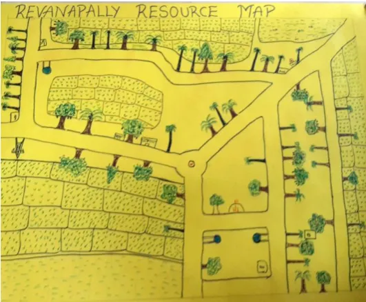
Resource mapping can be used as an effective ice breaking exercise as well as a tool to investigate the knowledge of the people about their own locality, resources and
spatial distribution. However, Resource Map is a tool that helps to learn about a community on its resource base. The primary concern is not to develop an accurate map but to get useful information about local perceptions of resources. The participants should develop the content of the map according to what is important to them.The aspects that includes in Resource Map are 1) Identifying valuable resources, 2) Ensure that everyone has access to the resources they need, 3) Avoid duplication of services and resources, 4) Enhance services, 5) Identify flexible funding strategies, 6) Use data to make informed decisions and (7) Cultivate new partnerships and relationships.
Resource Map: Revanpalli Village
Figure 3: Resource Map: Revanpalli Village
The village has abundant water for agriculture even the ground water levels are also good because of a huge lake construction on the Musi River flow. This water is usually used for agriculture but it is severely contaminated by industrial wastage and the overwhelming presence of fluoride. The villagers regularly buy drinking water in 20 liter cans or small bottles. A NGO is also working to inculcate awareness on health risks due to fluorosis and runs a water purifier center to supply the drinking water to villagers.
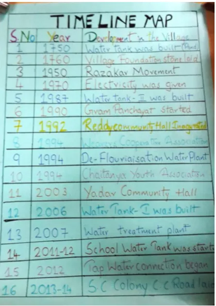
of past events, how the community perceived details on local events, how the community perceived them and the eventual impact of these events on the local area and the community.
Timeline Analysis of Revanpalli
Figure 4: Timeline Analysis of Revanpalli
In 1750, the lake, major water source to the village was build, this led to start permanent settlement by laying down the foundation stone for village in 1760.Electrification was completed in 1970 while Gram Panchayat was set up during 1990. In 1992, Reddy community hall was inaugurated, thereafter, associations for Weavers came into existence in 1994. Chaitanya youth association and fluorosis treatment plant were also constructed in the same year. Later, in 2003, Gollakuruma (Yadav) community hall was built on their own. Two water tanks were built in 2004 and 2005 respectively. During 2011-12, water tank in school premises was built. For the first time, the village had given water connections to each and every house in 2012. A road in SC colony was laid under the MNREGA scheme during 2013-14. However, there is a sequel of development that appeared in the village but it is not that significant when itis comparedto the
outside development.
Seasonality of Revanpalli Village
Figure 5: Seasonality of Revanpalli Village
The seasonality mapping which depictsthe work, migration, disease, income, expenditure, export and import of rice etc. It is found that people having leisure time during summers and sale of toddy (Palm Juice)will rise during this season. The villagers cultivate mostly rice and the seeds were sown during rainy season and summer. Health complications, seasonal fevers and flues are more prevalent during rainy season. Cold and skin disease are more during winter. However, summer is also noteworthy for sun stoke. Rainy season offers everyday work to all the labours to perform agricultural works. MGNREGS is more popular during summer in this village. Most of the festivals for local ditties and marriage ceremonies were performed during summer as they have more leisure time and it also convenient in terms of environment and climatic conditions.
Major Findings and Conclusions
The study is the compilation of all the observation, information obtained and overall experiences of the PRA exercise conducted in Revanpalli village for two days period. Further, it dwells into deeper to describe each tool with regard to the information obtained from the field through PRA methods and tools. Eventually, it shows the results and discussion with regard to overall PRA activity, with respect to the participation.
security records. It was a hamlet of Bhudhan Pochampally upto 1990, later it was politically separated. In fact, a lake that lured several groups to construct a new village where presently Revanpalli is located. Caste structure has its own significance in ekistics of village and its settlement, moreover, it consists of different section of people. The contagion of Fluoride is huge in this area and one can find number of fluorosis victims in Revanpalli. Surprisingly, this village has abundant water for irrigation but it lacks behind in socio-economic and educational aspects. There is no public health center and not even a single medical store in the village, therefore, they should walk to neighbouring villages for medical care. Transport facility in the village is also nominal and private auto-rickshaws are prime modes of transportation. Most of the people complained about the lack of concrete roads,sewage and drainage facilitieswhich are hardly found out in this village.
Village has a government school having only 20 students at present andit is painful to see that a village which is hardly 50 kms from a State capital lagging behind in education. Girl child are more among the school dropouts. Malnutrition is
appeared among adolescent girls, young women and lactic mothers. Another important issue which was observed is that the senior citizens were also being ignored and they are dire need of help from government and civil society as well. Because of social stigma, elderly has not been considered as serious problem but it is.
In terms of developmental activities, most of the activities have taken place without taking the opinion of the villagers into consideration, however, it is not adequate comparatively look at present needs of the village. The efforts and interventions of Non-Governmental Organizations and local political leaders are laudable, establishment of water purification plant and construction of community association buildings are noteworthy from their part. Government also connected neighbouring villages by laying
pacckaroads, further, it has kept efforts in construction of two water tanks, laying causeway on lake and constructing school building and Gram Panchayat Office. Eventually, it is observed that people are not satisfied whatever the development contributed by government and having a greater hope on newly formed Telangana State government for future development.
References
1. McCracken, Jennifer A, Jules N, Pretty, Gordon R, Conway (1988) An Introduction to Rapid Rural Appraisal for Agricultural Development’. London: International Institute for Environment and Development.
2. Bie SW (1998) Participatory Learning, Planning and Action toward LEISA. LEISA in Perspective: 15 Years, ILEIA. 14(2-3):27-31.
3. Freudenberger KS (n.d.) Rapid Rural Appraisal and Participatory Rural Appraisal: A Manual for Catholic Relief Services Field Workers and
Partners. Retrieved from
website: http://www.crsprogramquality.org/publica tions/2011/1/17/rapid-rural-appraisal-and-participat ory-rural-appraisal.html
4. Nick Emmel (2008) ‘Participatory Mapping: An Innovative Sociological Method’, ESRC National Centre for Research Methods, available at
http://eprints.ncrm.ac.uk/540/2/2008-07-toolkit-parti cipatory-map.pdf retrieved on 10/11/2015.
5. Scrimshaw NS, Gleason GR (1992) RAP, Rapid Assessment Procedures: Qualitative Methodologies for Planning and Evaluation of Health related Programmes. International Nutrition Foundation for developing countries.
6. Cavestro L (2003) PRA-Participatory Rural
Appraisal Concepts Methodologies and Techniques. Padua: University of Padua.
7. Mascarenhas J, Kumar PP (1991) Participatory Mapping and Modelling Users’. RRA Notes. 12(9-20).