A NEW DESIGN OF ATIS ARCHITECTURE FOR JIANGSU
PROVINCE, CHINA
Junping Xie
School of Automotive and Traffic Engineering, Jiangsu University,301 Xuefu Road, Zhenjiang, Jiangsu,
China
Yongfeng Ma
School of Transportation, Southeast University, 2 Si Pai Lou, Nanjing, Jiangsu,
China
Li Yuan
College of Civil and Transportation Engineering, Hohai University, 1 Xikang Road,
Nanjing, Jiangsu, China
Yan Liu
Department of English Language and Literature, Zhenjiang Watercraft College, 130 Taohuawu Road,
Zhenjiang, Jiangsu, China
ABSTRACT
Because of the outstanding performances and features, smart-phones have been developed over the past decade in China. More and more persons take smart-phones along using various applications to process many affairs instead of personal computers. With the sensor technology and multi-media display technology integrated in the smart-phones, the traffic information can be collected and distributed more efficiently. Therefore, the smart-phones play a more and more important role in advanced traveler information system (ATIS) nowadays. Although the smart-phones have changed the people's lives importantly, this potential resource has not been explicitly evaluated for ATIS applications. In this paper, the new ATIS architectures for Jiangsu Province were illustrated with the consideration on the broad usage of smart-phones based on Chinese national Intelligent Transportation System (ITS) architecture and Jiangsu provincial ITS architecture.
General Terms
Intelligent Transportation System
Keywords
ATIS; architecture; smart-phone; ITS
1.
INTRODUCTION
deploy because of limit for new infrastructures, complexity and diversity of systems and the problem of non-interaction
between novel and existing systems[1]. Consequently, the ITS architecture plays a role in facility related to structural and
functional plans and characteristic of interaction between two or more systems[2]. Thus, the efficiency of ITS systems depends on ITS architecture. The U.S. Department of Transport (U.S. DOT) published national ITS architecture first in the world to provide a common framework for planning, defining, and integrating ITS. The architecture keeps improved and reaches the latest version 7.1. Based on the national ITS architecture, McTrans Software Center at the University of Florida has developed a software application Turbo Architecture which supports development of regional and project ITS architectures using the national ITS architecture as a starting point. The software is updated to version 7.1 according to
national architecture[3]. One the other hand, there is a short history of researching ITS in China. The National Center of
ITS Engineering and Technology (ITSC), which plays an important role in Chinese ITS researches, developed Chinese
national ITS architecture in 2003, and a computer-aided ITS architecture development tool called ITSA-CASS[4].
However, the version 2 for the Chinese national architecture has not been published so far. Aided by the Chinese national ITS architecture, some regional ITS architectures have been developed gradually, such as Jiangsu provincial ITS architecture[5].
With the recent development in sensing and communication technology, advanced traveler information systems (ATIS) become the most convenient and economic subsystem in ITS. ATIS contain technological framework that: (1) collects traffic variables in the large traffic networks and with the high temporal frequency; (2) processes the collected data and reveal the meaningful information from it; (3) disseminates the instructive real-time information to the travelers in the form of either colored network maps or suggested trip characteristics such as departure time, mode of transportation and
assigned path[6]. The travelers can save their traveling time using applications installed in smart-phones, which embedded
GPS or other sensors. In that way ATIS systems reduce the total delay, improve the user’s comfort and satisfaction,
decrease the pollutions and noises and enhance the overall productivity within a city[7].
More and more people can not be separated from smart-phones, which are usually seen as the most convenient way to deliver real-time information to the users. With the various desktop applications and numerous smart sensors such as GPS, accelerometers, inertial measurements, manometers, microphones and even cameras, smart-phones play an important role in colleting traffic information. Although smart-phones benefit ATIS systems significantly, this potential is not explicitly considered for ATIS architecture in China.
In this paper, a basic ATIS architecture was designed for Jiangsu Province of China, which had fully considered the impact of smart-phones.
2.
OBJECTS OF ATIS ARCHITECTURE
The objectives of the ATIS architecture for Jiangsu Province are listed as follows.
The architecture should be adapted to the existing Chinese national ITS architecture and the Jiangsu Provincial ITS architecture.
The architecture can guide ATIS constructions with more efficiency and safety.
The architecture should consider the potential of smart-phones fully.
3.
USER SERVICES OF ARCHITECTURE
A survey was conducted to collect the travel information that the travelers needed. The purpose of this survey is to prepare for the user services. The survey results determine the information that the system should provide for the travelers of pre-trip and en-route. The results of the survey can benefit the determination of the user services.
The user services are divided into 4 bundles, 19 services and 67 sub-services respectively. The user service bundles and user services are listed in Table 1, while the sub-services are left out for the reason of space.
Table 1. User services for ATIS architecture
User Service Bundle User Service
Traffic management
Real-time traffic data detection
Vehicle detection with location based service (LBS) Traffic violation punishment
Traffic control device management Traffic incidents management
Weather detection Security control
Road construction and maintenance management
Traffic information service
Pre-trip information service En-route information service Individual information service
Smart-phone information service
Static navigation with smart-phone apps Dynamic navigation with smart-phone apps
Peripheral life service information
ATIS data management
Data access and storage Dada processing Data exchange and share Data application support
Data security
4.
ARCHITECTURE FOR ATIS
The purpose of the ATIS architecture is to guide the system construction on the macro-level in Jiangsu Province. The architecture usually includes logic architecture and physical architecture.
4.1
Logic architecture
Manage Data
Provide
Traffic
Information
Service
Manage Traffic
Traff ic R eleva nt D ata Traffic Management CenterTraffic Mana gemen
t Support D ata Tr
affic M anag
em ent A
pp lie
d D ata Tra
ffic M anag
em en
t Syn th
etic al D
ata Information Service Provider Tra ffic D ata Academic Institute Tra ffic Dat a System Operator Data Processing Command Relevant Organization Traffic Data System Operator System Status Information
System Operator
System Maintenance Command
Map-updating Provider Map-updating Data Weather Department Weather Data Traf fic D
ata
Traf fic D
ata Req uire men t Pers onal Info rmat ion Pers onal Info rmat ion Stor age Com man d Pers onal Info rmat ion Req uire men t Media Traffic Management Information Emergency Management Department Emergency Aid Requirement Emergency Management Department Emergency Aid Coordination Traffic Infrastructure Management Department Road
way C
onstr
uctio
n
Man
agem
ent In
forma tion Public Security Department Security Control Information Traffic Infrastructure Management Department Roadway Construction Reruirement Public Security Department Security Control Demand Traffic Management Center Traffic Management Command Traffic Management Center Traffic Management Center Input Data
Law Enforcement
Department
Traffic V iolation
Punishme nt Data
Law Enforcement
Department
Traff
ic Vi
olatio
n
Punis
hmen
t Req
uirem ent Electronic Payment Card Management Center Individual Information Payment Confirmation Clearing house Stipendiary Information
and Service Fees Data
Map-updating Provider Map Data Requirement Map-updating Provider Map Data Driver Driver Needed Information Other Transportation Operator Transportation Operators Information Driver Driver Needed Information Requirement Traffic Information Service Provide Opera
tion D
ata
Traffic Information
Service Provide
Traffic Releva nt Information Traffic Information Service Provide Traffic Relevant Information Requirement Travel Roadway Transportation Operator Roadway Service information Requirement Travel Information Weather Department Wea ther Data
Roadway Transportation
Operator
Roadw ay Service inform ation R e a l T ra ff ic D a ta D e te c ti o n R e q u ir e m e n t T ra ff ic M a n a g e m e n t D a ta R e q u ir e m e n t R e a l T ra ff ic D a ta T ra ff ic M a n a g e m e n t D a ta Mobile Operator Veh icle Det ectio n with LBS
Provide
Smart-phone Information
Static/Dynamic navigation Information for Smart-phonePeripheral Life Service Information for Smart-phone Peripheral Life Service Information Requirement
Static/Dynamic navigation Information Requirement
Sm ar t-p ho ne A pp S up po
rt D ata Smart-phone User Smart-phone App Provider Smart-phone Service Information Smart-phone App Service Information
Fig 1: Top level logic data flow diagram of ATIS
4.2
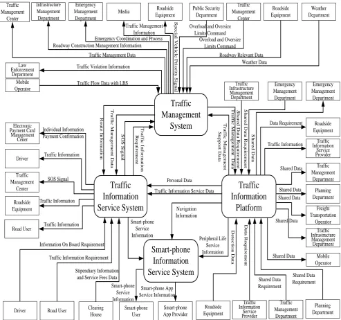
Physical architecture
Electronic Payment Card Management Cener
Traffic
Information
Service System
Traffic
Management
System
Traffic
Information
Platform
Traffic Management Center Roadside Equipment Road UserDriver Road User Clearing House Traffic Management Department Planning Department Emergency Management Department Traffic Infrastructure Management Department Traffic Information Service Provider Emergency Management Department Roadside Equipment Roadside Equipment Traffic Information Service Provider Traffic Management Department Planning Department Traffic Infrastructure Management Department Public Security Department Traffic Management Center Roadside Equipment Weather Department Roadside Equipment Media Emergency Management Department Traffic Management Center Law Enforcement Department Mobile Operator S p e c ia l V e h ic le P ri o ri ty S ig n a l
Overload and Oversize Limits Command
Overload and Oversize Limits Command
Roadway Relevant Data Weather Data
Personal Data
Traffic Information Service Data
T ra ff ic I n fo rm a ti o n R e q u ir e m e n t S O S S ig n a l T ra ff ic M a n a g e m e n t D a ta R o u te I n fo rm a ti o n T ra ff ic M a n a g e m e n t S u p p o rt D a ta T ra ff ic M a n a g e m e n t D a ta S h a re d D a ta R e q u ir e m e n t S h a re d D a ta R e q u ir e m e n t S h a re d D a ta Data Requirement Traffic Information Shared Data Shared Data Freight Transportation Operator Shared Data Shared Data D e te c ti o n D a ta D a ta R e q u ir e m e n t Shared Data Requirement Shared Data Requirement Stipendiary Information
and Service Fees Data Traffic Information Requirement Information On Board Requirement Driver Traffic Information
SOS Signal Traffic Information Traffic Information Individual Information Payment Confirmation Traffic Management Information Emergency Coordination and Process
Traffic Management Data
Traffic Violation Information
Traffic Flow Data with LBS
Smart-phone
Information
Service System
Infrastructure Management DepartmentRoadway Construction Management Information
Navigation Information Peripheral Life Service Information Smart-phone User Smart-phone App Provider Smart-phone Service Information Smart-phone App Service Information Mobile Operator Shared Data Smart-phone Service Information
Fig 2: Top level logic data flow diagram of ATIS
5.
CONCLUSIONS
A new design of ATIS architecture for Jiangsu province in China was proposed with the consideration of the great impact of smart-phones. The main parts of the architecture, user service, top level logic data flow diagram and top level physical flow diagram were illustrated. This experience can be shared by the other designers to construct the architectures of ITS or its subsystems in China.
6.
ACKNOWLEDGMENTS
7.
REFERENCES
[1] Arrayangkool A. and Unakul A. (2009, October). A flexible Intelligent Transportation System architecture model
with object oriented methodology and UML. Paper presented at the 9th International Symposium on Communications and Information Technology. .
[2] Meier R., Harrington A. and Cahill V. (2005, September). A framework for integrating existing and novel intelligent
transportation systems. Paper presented at the Proceedings of Intelligent Transportation Systems, 2005 IEEE.
[3] United State Department of Transport (US DOT). National ITS Architecture Version 7.1. Retrieved September 15,
2015, from http://www.its.dot.gov/arch/index.htm.
[4] The National Center of ITS Engineering and Technology (ITSC). Introductions of Tenth Five-Year Projects.
Retrieved June 10, 2015, from http://www.itsc.com.cn/ViewNews.asp?ID=7533.
[5] National Center of ITS Engineering and Technology (ITSC) (2003). Jiangsu Provincial ITS Architecture and
Planning (Technical Report). Jiangsu Province, China.
[6] Ansar R. et al. (2014, October). Evaluation of smart-phone performance for real-time traffic prediction. Paper
presented at the 2014 IEEE 17th International Conference on Intelligent Transportation Systems (ITSC), Qingdao, China.
[7] Toledo T. and Beinhaker R. (2006). Evaluation of the potential benefits of advanced traveler information systems.